Dougherty (island) on:
[Wikipedia]
[Google]
[Amazon]

 Dougherty is the name of a

 Dougherty is the name of a
 phantom island
A phantom island is a purported island which was included on maps for a period of time, but was later found not to exist. They usually originate from the reports of early sailors exploring new regions, and are commonly the result of navigati ...
that was believed to be located in the extreme south of the Pacific Ocean
The Pacific Ocean is the largest and deepest of Earth's five oceanic divisions. It extends from the Arctic Ocean in the north to the Southern Ocean (or, depending on definition, to Antarctica) in the south, and is bounded by the continen ...
, roughly halfway between Cape Horn
Cape Horn ( es, Cabo de Hornos, ) is the southernmost headland of the Tierra del Fuego archipelago of southern Chile, and is located on the small Hornos Island. Although not the most southerly point of South America (which are the Diego Ramírez ...
and New Zealand
New Zealand ( mi, Aotearoa ) is an island country in the southwestern Pacific Ocean. It consists of two main landmasses—the North Island () and the South Island ()—and over 700 smaller islands. It is the sixth-largest island count ...
. It is named for Captain Dougherty of the ''James Stewart'', an English whaler, who in 1841 reported discovering it at . He described it as 5–6 miles long with a high bluff to the northeast and covered in snow. Dougherty's discovery was confirmed by Captain Keates of the ''Louise'' in 1860, giving its coordinates as , and by Captain Stannard of the ''Cingalese'' in 1886, giving the location as .
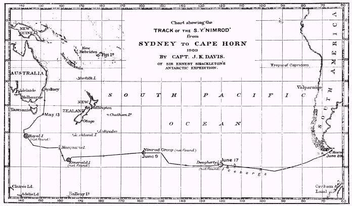
However, thorough exploration of the area in the late 19th and early 20th centuries established that the island does not exist. Captain Davis of the ''Nimrod
Nimrod (; ; arc, ܢܡܪܘܕ; ar, نُمْرُود, Numrūd) is a biblical figure mentioned in the Book of Genesis and Books of Chronicles. The son of Cush and therefore a great-grandson of Noah, Nimrod was described as a king in the land of ...
'' suggested that the most likely explanation was that Dougherty, Keates, and Stannard had all been deceived by fog banks or icebergs (none, after all, claimed to have actually landed on the island): "I am inclined to think Dougherty Island has melted."
The island continued to appear on maps as late as 1934.
See also
*Royal Company's Islands
The Royal Company's Islands are a group of phantom islands reported by some early explorers to lie southwest of Tasmania. They were first heard of before 1840, but the original report cannot be traced. Many old charts show them at or .
The isl ...
* Emerald Island (phantom)
The Emerald Island is a phantom island reported to lie between Australia and Antarctica and south of Macquarie Island. It was first sighted by the British sealing ship ''Emerald'', captained by William Elliot, in December 1821,Headland, Robert ...
* Nimrod Islands
The Nimrod Islands were a group of islands first reported in 1828 by Captain Eilbeck of the ship ''Nimrod'' while sailing from Port Jackson around Cape Horn. Their reported location was east of Emerald Island and west of Dougherty Island, at app ...
* Sandy Island, New Caledonia
Sandy Island (sometimes labelled in French , and in Spanish ) is a non-existent island that was charted for over a century as being located near the French territory of New Caledonia between the Chesterfield Islands and Nereus Reef in the ...
, a phantom island that remained on many maps until the early 21st century
References
*Hamilton-Paterson, James. ''The Great deep: the sea and its thresholds''. New York: Holt, 1993. *Ramsay, Raymond H. ''No Longer on the Map: discovering places that never were''. New York: Viking Press, 1972. {{ISBN, 0-670-51433-0 Phantom subantarctic islands