Dehra Compass on:
[Wikipedia]
[Google]
[Amazon]
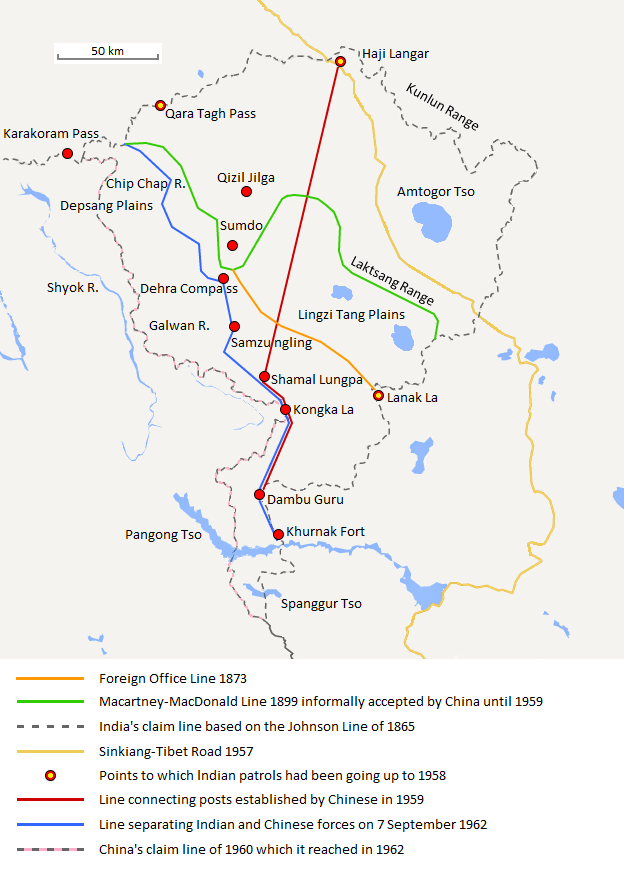
Dehra Compass or Dehra Kompas () is the location of a historical caravan campsite in Aksai Chin. It is under Chinese control and claimed by India. Historically, the camp was used by caravans journeying between the
 Kompas La or Dehra La () is the pass through a nearby
Indian subcontinent
The Indian subcontinent is a list of the physiographic regions of the world, physiographical region in United Nations geoscheme for Asia#Southern Asia, Southern Asia. It is situated on the Indian Plate, projecting southwards into the Indian O ...
and Tarim Basin
The Tarim Basin is an endorheic basin in Northwest China occupying an area of about and one of the largest basins in Northwest China.Chen, Yaning, et al. "Regional climate change and its effects on river runoff in the Tarim Basin, China." Hydr ...
. It was traversed by European explorers during the 1800s. At one point, there were stone shelters constructed at this location to facilitate camping.
Etymology
'Dehra' is derived from thePunjabi
Punjabi, or Panjabi, most often refers to:
* Something of, from, or related to Punjab, a region in India and Pakistan
* Punjabi language
* Punjabi people
* Punjabi dialects and languages
Punjabi may also refer to:
* Punjabi (horse), a British Th ...
and Seraiki language word 'dera', meaning camp, while 'Compass' comes from the name of a survey officer, Kompas Walla.
Sino-Indian border dispute
In theevents leading to the Sino-Indian War
A long series of events triggered the Sino-Indian War in 1962. According to John W. Garver, Chinese perceptions about the Indian designs for Tibet, and the failure to demarcate a common border between China and India (including the Indian Forward ...
, Indian patrols used Kompas La and Dehra Compass to monitor the area. Chinese troops gained control of this area after May 1961.
Kompas La
 Kompas La or Dehra La () is the pass through a nearby
 mountain spur
A spur is a lateral ridge or tongue of land descending from a hill, mountain or main crest of a ridge. It can also be defined as another hill or mountain range which projects in a lateral direction from a main hill or mountain range.
Examples of ...
. Historically the pass was to the south reached an elevation of . Present day, the vehicle accessible gravel road routed to the east, while still one of the highest in the world, only reaches elevation of , serving the Chinese border outpost of Heweitan
Heweitan () is the location of a Chinese border outpost in the region of Aksai Chin that is controlled by China (as part of Hotan County, Hotan Prefecture, Xinjiang) but disputed by India. According to the Chinese Ministry of National Defense, it ...
to the west.
See also
*List of locations in Aksai Chin
This is a list of basins, camping grounds, lakes, mountains, mountain passes, outposts, plains, rivers, ruins, settlements, streams, valleys, villages, and other geographical features located in (or partially included in) the sparsely populated Ak ...
Notes
References
{{Mountain passes of China Mountain passes of China Mountain passes of Xinjiang Areas occupied by China through the Sino-Indian War Aksai Chin