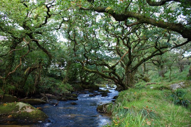
De Lank River on:
[Wikipedia]
[Google]
[Amazon]


 The De Lank River ( kw, Dowr Dinlonk, meaning ''ravine fort river'') is a small river in north
Joint Nature Conservation Committee: River Camel SAC. Retrieved April 2010


 The De Lank River ( kw, Dowr Dinlonk, meaning ''ravine fort river'') is a small river in north
 Cornwall
Cornwall (; kw, Kernow ) is a historic county and ceremonial county in South West England. It is recognised as one of the Celtic nations, and is the homeland of the Cornish people. Cornwall is bordered to the north and west by the Atlantic ...
, England. It is a tributary of the River Camel
The River Camel ( kw, Dowr Kammel, meaning ''crooked river'') is a river in Cornwall, England. It rises on the edge of Bodmin Moor and with its tributaries its catchment area covers much of North Cornwall. The river flows into the eastern Cel ...
and is approximately nine miles (14.5 km) long from its source on Bodmin Moor
Bodmin Moor ( kw, Goon Brenn) is a granite moorland in north-eastern Cornwall, England. It is in size, and dates from the Carboniferous period of geological history. It includes Brown Willy, the highest point in Cornwall, and Rough Tor, a s ...
to its confluence with the Camel two miles (3 km) south of St Breward
St Breward ( kw, S. Bruwerd) is a civil parish and village in Cornwall, England, United Kingdom. It is on the western side of Bodmin Moor, about 6 miles (10 km) north of Bodmin. At the 2011 census the parish population including Cooksland ...
.
The De Lank River springs from Rough Tor Marsh between the two highest peaks on Bodmin Moor, Rough Tor
Rough Tor (), or Roughtor, is a tor on Bodmin Moor, Cornwall, United Kingdom. The site is composed of the tor summit and logan stone, a neolithic tor enclosure, a large number of Bronze Age hut circles, and some contemporary monuments.
Topon ...
and Brown Willy
Brown Willy (possibly meaning "hill of swallows" or meaning "highest hill") is a hill in Cornwall, England, United Kingdom. The summit, at above sea level, is the highest point of Bodmin Moor and of Cornwall as a whole. It is about northwest ...
. Initially, its course is south between the peaks before turning southwest, past the southern foot of Garrow Tor
Garrow Tor is a bare, tor-crowned hill, high, located on Garrow Downs in the northwest of Bodmin Moor in the county of Cornwall, England, UK.Ordnance Survey 1:25,000 ''Explorer'' map series, No. 109
At the summit of Garrow Tor are granite rock ...
, heading for the Camel. The De Lank's course is within the civil parish
In England, a civil parish is a type of administrative parish used for local government. It is a territorial designation which is the lowest tier of local government below districts and counties, or their combined form, the unitary authority ...
of St Breward.
The river flows through an isolated area with few riverside settlements. Its upper reaches cross a bare moorland plateau and its lower reaches are characterised by ancient deciduous woodland. At Lank
Lank may refer to:
* Lank (surname)
* Lank, Cornwall, a hamlet in Cornwall, United Kingdom
* Lank Rigg, fell in the English Lake District
See also
* Lanc (disambiguation) Lanc may refer to:
__NOTOC__ Organizations
* National-Christian Defense L ...
, near the confluence with the River Camel, the river flows through De Lank Quarries
De Lank Quarries () is an active quarry and a 54-acre geological Site of Special Scientific Interest in St Breward parish, north Cornwall, England, UK. The quarry, which received its SSSI notification in 1994, takes its name from the nearby De ...
(the site of a Geological SSSI).
The De Lank River is an important wildlife habitat noted for diverse and abundant flora and fauna. Together with the River Camel, the De Lank is an important habitat for the otter
Otters are carnivorous mammals in the subfamily Lutrinae. The 13 extant otter species are all semiaquatic, aquatic, or marine, with diets based on fish and invertebrates. Lutrinae is a branch of the Mustelidae family, which also includes wea ...
which is present along the whole length of the river. The De Lank is included in the Camel Special Area of Conservation
A Special Area of Conservation (SAC) is defined in the European Union's Habitats Directive (92/43/EEC), also known as the ''Directive on the Conservation of Natural Habitats and of Wild Fauna and Flora''. They are to protect the 220 habitats and ap ...
(SAC) and River Camel SSSI
A Site of Special Scientific Interest (SSSI) in Great Britain or an Area of Special Scientific Interest (ASSI) in the Isle of Man and Northern Ireland is a conservation designation denoting a protected area in the United Kingdom and Isle of ...
.Joint Nature Conservation Committee: River Camel SAC. Retrieved April 2010
Location
* Source coordinates * Confluence coordinatesReferences
{{authority control Rivers of Cornwall 1DeLank