Caestert on:
[Wikipedia]
[Google]
[Amazon]
Mount Saint Peter (
 In the part of Mount Saint Peter that is in the Flemish municipality of Riemst, archaeological evidence of an Iron Age
Image:Interieur, overzicht mergelgrot en rechts een muurtekening - Maastricht - 20534289 - RCE.jpg, Late Medieval graffiti in a quarry
Image:Joris van der Haagen - Gezicht over de Maas op Slavante bij Maastricht.JPG, Painting by
 At Mount Saint Peter the rivers Geer and Meuse have cut into the limestone plateau known in the east as the Herve plateau and in the west as Hesbaye. The succeeding geologic layers include loess,
 Mount Saint Peter is a Natura 2000 protection area. Because of its limestone soil, the hill is exceptional in its botanical variety. It is the northern limit for a number of species of orchids due to its favorable microclimate. Some of the orchids found there include: ''
Image:Ophrys apifera flower3.jpg, Orchid ''


Image:Hoeve Lichtenberg.jpg, Castle ruins Lichtenberg
Image:Vise-Hoeve Caestert (3).JPG, Remains of Caestert
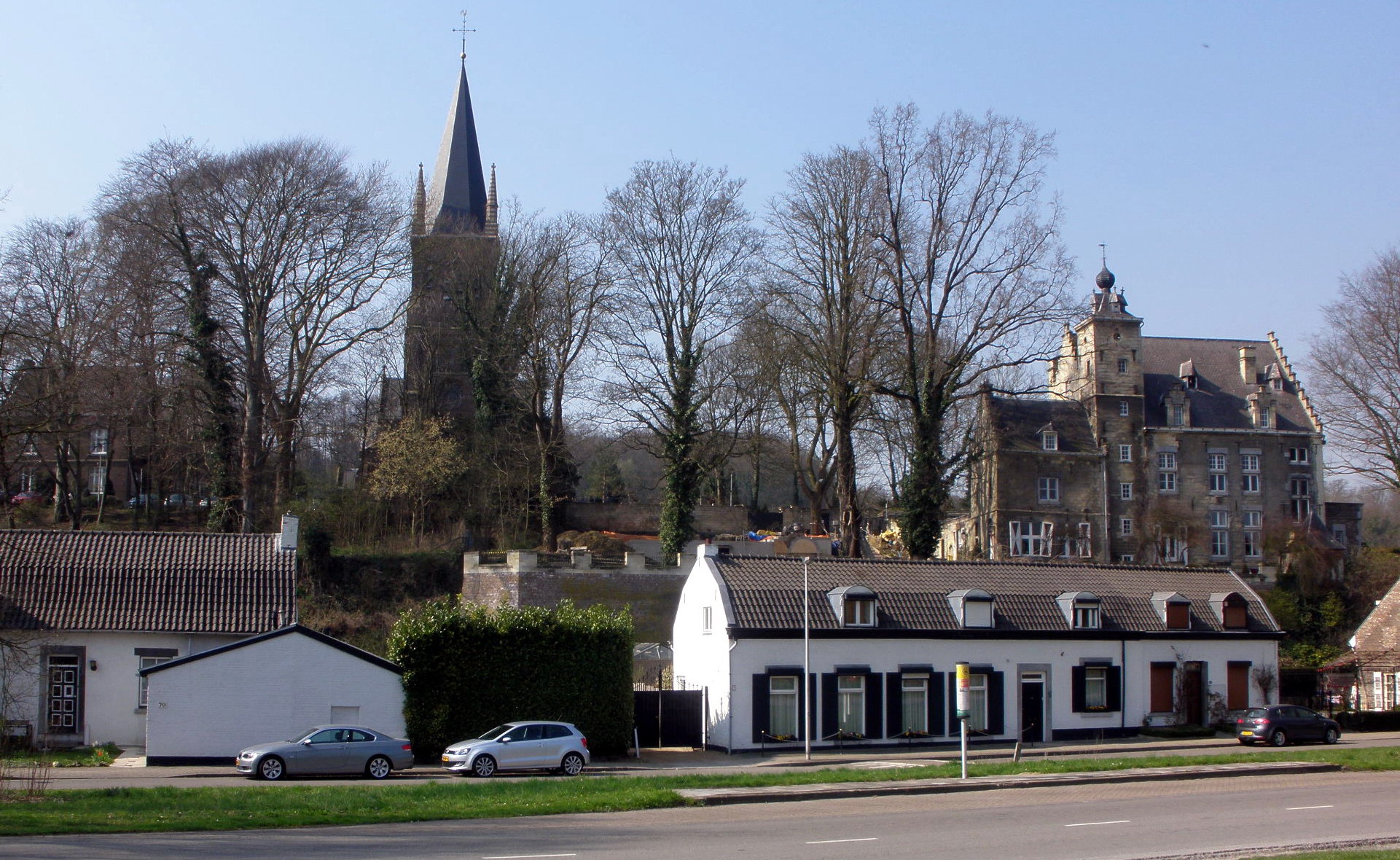
Image:Maastricht - rijksmonument 27963 - Huis de Torentjes - Lage Kanaaldijk 63 20100515.jpg, House De Torentjes
Image:20130504 Maastricht Sint-Pietersberg Hoeve Zonneberg 01.JPG, Farmstead Zonneberg
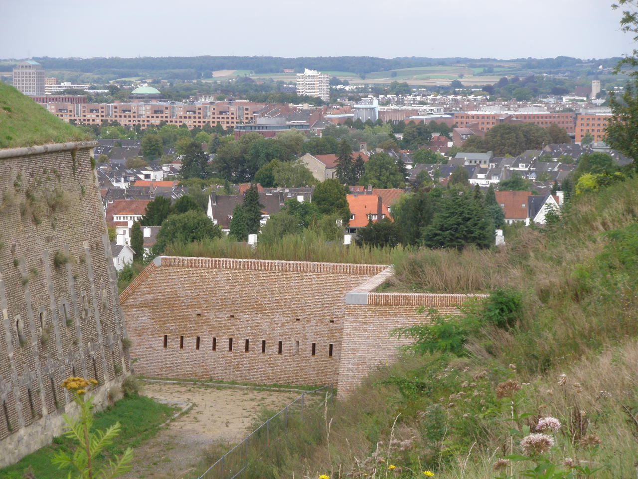
Image:Maastricht 2008 Fortress Sint Pieter 02.jpg, Fortress Sint-Pieter
Image:20130504 Maastricht Slavante 04 Sint-Antoniuskapel.JPG, Saint Anthony's Chapel
Image:Maastricht - rijksmonument 506684 - Slavante 1 20100724.jpg, Casino Slavante
Image:Ebenemael 002.jpg, Fortress Eben-Emael
Tourist information on website maastrichtunderground.nl
(partly in English)
Montagne Saint-Pierre
site describing the region
Tourist information on website ''Regionaal Landschap Haspengouw en Voeren''
'Sint-Pietersberg' on website ''Natuurmonumenten''
Information over quarries Mount Saint Peter on website Kevin Amendt
{{in lang, nl Plateaus of Europe Mountains and hills of the Netherlands Mountains and hills of Flanders Mountains and hills of Liège Province Landforms of Limburg (Belgium) Hills of South Limburg (Netherlands) Geography of Maastricht Visé
French
French (french: français(e), link=no) may refer to:
* Something of, from, or related to France
** French language, which originated in France, and its various dialects and accents
** French people, a nation and ethnic group identified with Franc ...
: ''Montagne Saint-Pierre''; Dutch: ''Sint-Pietersberg''), also referred to as Caestert Plateau, is the northern part of a plateau running north to south between the valleys of the river Geer
Geer (; wa, Djer) is a municipality of Wallonia located in the province of Liège, Belgium.
On January 1, 2006, Geer had a total population of 2,854. The total area is 23.62 km² which gives a population density of 121 inhabitants per k ...
to the west, and the Meuse to the east. The plateau runs from Maastricht in the Netherlands, through Riemst
Riemst (; li, Riems) is a small town and a municipality in the Belgian province of Limburg. Riemst is in the Flemish speaking area of Belgium.
On January 1, 2018 Riemst had a total population of 16,665. The total area is 57.88 km² which ...
in Belgian Limburg
Limburg ( nl, Limburg, ; li, Limburg or ''Wes-Limburg'' ; french: Limbourg, ) is a province in Belgium. It is the easternmost of the five Dutch-speaking provinces that together form the Region of Flanders, one of the three main political and c ...
almost to the city of Liège in Belgium, thus defining the topography of this border area between Flanders, Wallonia and the Netherlands. The name of the hill, as well as the nearby village and church of Sint Pieter
Sint Pieter (Saint Peter) is a neighbourhood in the city of Maastricht, in the Dutch province of Limburg. It is located on the western bank of the river Meuse, in the south of the city, and borders Belgium (both Flanders and Wallonia). It is ...
and the fortress of Sint Pieter, refers to Saint Peter
) (Simeon, Simon)
, birth_date =
, birth_place = Bethsaida, Gaulanitis, Syria, Roman Empire
, death_date = Between AD 64–68
, death_place = probably Vatican Hill, Rome, Italia, Roman Empire
, parents = John (or Jonah; Jona)
, occupation ...
, one of the Twelve Apostles.
Principal characteristics
The plateau, of which Mount Saint Peter is part, is bounded on the east by the Meuse river (Dutch: ''Maas'') and on the west by the Geer (''Jeker''). Since the 1930s, theAlbert Canal
The Albert Canal (, ) is a canal located in northeastern Belgium, which was named for King Albert I of Belgium. The Albert Canal connects Antwerp with Liège, and also the Meuse river with the Scheldt river. It also connects with the Dessel ...
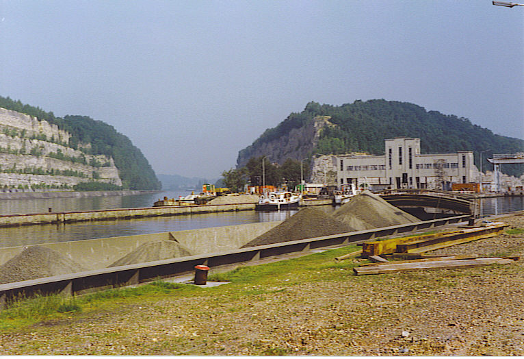
divides the hill in two sections. Near the small Liège Province village of Lanaye (Dutch: ''Ternaaien''), the canal cuts through the ridge over a length of and deep. The Lanaye locks at the eastern end of the cut permit boats to pass from the upper Meuse and the Albert Canal to the lower Meuse and Rhine basin. To the east of these locks the Meuse has altered its course, creating backwaters and old channels.
Mount Saint Peter's limestone composition, its deposits of flint nodules and its geographic position make it a remarkable place. The locale has been mined for flint since Neolithic times. The network of mining tunnels extended by the 19th century but was severely shortened in the 20th century by surface mining. These days, Mount Saint Peter is considered an important nature reserve, as well as an area for recreation and tourism.
History
 In the part of Mount Saint Peter that is in the Flemish municipality of Riemst, archaeological evidence of an Iron Age
 fortress
A fortification is a military construction or building designed for the defense of territories in warfare, and is also used to establish rule in a region during peacetime. The term is derived from Latin ''fortis'' ("strong") and ''facere'' ...
has been found. The fortress is one of the strongest contenders for being identified as the fortress Atuatuca
Atuatuca (or Aduatuca) is the name of two ancient fortified settlements located in the eastern part of modern Belgium, between the Scheldt and Rhine rivers. The oldest one, ''Atuatuca Eboronum'', attested during the Gallic Wars (58–50 BC), was t ...
of the Eburones
The Eburones ( Greek: ) were a Gallic- Germanic tribe dwelling in the northeast of Gaul, in what is now the southern Netherlands, eastern Belgium and the German Rhineland, in the period immediately preceding the Roman conquest of the region. T ...
, which played an important role in Julius Caesar's commentaries on his wars in Gaul. Dendrochronological
Dendrochronology (or tree-ring dating) is the scientific method of dating tree rings (also called growth rings) to the exact year they were formed. As well as dating them, this can give data for dendroclimatology, the study of climate and atmo ...
evidence was once thought to count against this proposal, but more recent review of the evidence has reinvigorated the idea.
During the Middle Ages several castles were built on the hill, of which various ruins remain. The hill was favoured by attackers during the various sieges of Maastricht, most notably by Louis XIV of France
, house = Bourbon
, father = Louis XIII
, mother = Anne of Austria
, birth_date =
, birth_place = Château de Saint-Germain-en-Laye, Saint-Germain-en-Laye, France
, death_date =
, death_place = Palace of Ve ...
in the Siege of Maastricht (1673)
The siege of Maastricht took place from 15 to 30 June 1673 during the Franco-Dutch War of 1672 to 1678, when a French army captured the Dutch fortress of Maastricht. The city occupied a key strategic position on the Meuse river and its capt ...
. As a result of this, the fortress Sint-Pieter was built on the northern edge.
Around 1765 the skull of a ''Mosasaurus
''Mosasaurus'' (; "lizard of the Meuse River") is the type genus (defining example) of the mosasaurs, an extinct group of aquatic squamate reptiles. It lived from about 82 to 66 million years ago during the Campanian and Maastrichtian stages o ...
'' was discovered here in a limestone quarry, one of the first recognised reptile fossils, which was later acquired by the Teylers Museum in Haarlem. A more famous ''Mosasaurus'' fossil was found between 1770 and 1774 but was confiscated by the French in 1794 and is now in the Muséum national d'Histoire naturelle in Paris. Later dinosaur remains were discovered here as well, belonging to ''Betasuchus
''Betasuchus'' is a genus of theropod dinosaur which lived during the Late Cretaceous Period. ''Betasuchus'' is, besides '' Orthomerus'', the only dinosaur genus named from remains found in the Netherlands and the only non-avian theropod found ...
'' and ''Orthomerus
''Orthomerus'' (meaning "straight femur") is a genus of dubious hadrosaurid dinosaur from the Late Cretaceous of the Netherlands. It is today an obscure genus, but in the past was conflated with the much better known ''Telmatosaurus''.
Discovery ...
'', as well as turtles and fossils of smaller creatures of the sea.
From 1930 through 1939 the Albert Canal was constructed, cutting through parts of Mount Saint Peter. The first ships went through in 1940. The hill's strategic location made it the site of Fort Eben-Emael
Fort Eben-Emael (french: Fort d'Ében-Émael, ) is an inactive Belgian fortress located between Liège and Maastricht, on the Belgian-Dutch border, near the Albert Canal, outside the village of Ében-Émael. It was designed to defend Belgi ...
(1931–35), a major artillery defence point in the Belgian defences against any invading forces coming from Nazi Germany. At the opening of the war, the entire installation was taken quickly by a relatively small number of German paratroopers.
Joris van der Haagen
''Surroundings of Arnhem'' Fine Arts of Carcassonne
Joris Abrahamsz. van der Haagen (c. 1615 – The Hague, 23 May 1669 (buried)) was a Dutch Golden Age painter specialized in landscapes.
Biography
It is unclear where Joris van der Haag ...
(17th century)
Image:St Pieter Maastricht 1799.jpg, Limestone quarries in 1799
Image:MosasaurDiscovery.jpg, Discovery of the Mosasaurus
''Mosasaurus'' (; "lizard of the Meuse River") is the type genus (defining example) of the mosasaurs, an extinct group of aquatic squamate reptiles. It lived from about 82 to 66 million years ago during the Campanian and Maastrichtian stages o ...
Geology and mining activities
 At Mount Saint Peter the rivers Geer and Meuse have cut into the limestone plateau known in the east as the Herve plateau and in the west as Hesbaye. The succeeding geologic layers include loess,
 gravel
Gravel is a loose aggregation of rock fragments. Gravel occurs naturally throughout the world as a result of sedimentary and erosive geologic processes; it is also produced in large quantities commercially as crushed stone.
Gravel is classifi ...
, quartz sand and chalk
Chalk is a soft, white, porous, sedimentary carbonate rock. It is a form of limestone composed of the mineral calcite and originally formed deep under the sea by the compression of microscopic plankton that had settled to the sea floor. Chalk ...
y limestone of the Maastricht Formation
The Maastricht Formation (Dutch: ''Formatie van Maastricht''; abbreviation: MMa), named after the city of Maastricht in the Netherlands, is a geological formation in the Netherlands and Belgium whose strata date back to the Late Cretaceous, within ...
with inclusions of flint. The chalk deposits contain numerous fossils of sea urchins, clam
Clam is a common name for several kinds of bivalve molluscs. The word is often applied only to those that are edible and live as infauna, spending most of their lives halfway buried in the sand of the seafloor or riverbeds. Clams have two she ...
s and belemnites Belemnites may refer to:
*Belemnitida
Belemnitida (or the belemnite) is an extinct order of squid-like cephalopods that existed from the Late Triassic to Late Cretaceous. Unlike squid, belemnites had an internal skeleton that made up the cone. ...
.
Humans have used the site since the lower Paleolithic period. The area around Spiennes is known for its flint mines. Limestone has been quarried in the area for building stone and fertilizer for many centuries. Several of Maastricht's medieval churches were built from local stone, incorrectly referred to as ''mergel'' (marl
Marl is an earthy material rich in carbonate minerals, clays, and silt. When hardened into rock, this becomes marlstone. It is formed in marine or freshwater environments, often through the activities of algae.
Marl makes up the lower part o ...
). The quarrying of limestone has created a vast network of subterranean corridors, also incorrectly referred to as ''grotten'' (cave
A cave or cavern is a natural void in the ground, specifically a space large enough for a human to enter. Caves often form by the weathering of rock and often extend deep underground. The word ''cave'' can refer to smaller openings such as se ...
s). Although vast sections of these "caves" have now disappeared through surface mining, other sections are well-preserved. Guided tours of these limestone quarries, some with ancient inscriptions, drawings and other works of art, constitute one of Maastricht's main tourist attractions.
In modern times limestone from Mount Saint Peter continues to be quarried in surface mines, mainly for portland cement production. Abandoned quarries in the Belgian part of the hill are used to dispose of ashes from municipal waste incinerators. A large quarry
A quarry is a type of open-pit mining, open-pit mine in which dimension stone, rock (geology), rock, construction aggregate, riprap, sand, gravel, or slate is excavated from the ground. The operation of quarries is regulated in some juri ...
and cement factory operated by ENCI exists since 1921 in the Dutch part of the hill. The quarrying of limestone in a protected nature area was controversial for many years but for economic reasons ENCI was able to extract most of the mount's limestone, creating a vast area of connected quarries. In 2010 it was decided that by 2018 the quarry will close down. Various plans for redevelopment of both the quarry and the factory site have been presented in recent years. Parts of the quarry that were abandoned years ago have been taken over by nature once again.
Ecology
 Mount Saint Peter is a Natura 2000 protection area. Because of its limestone soil, the hill is exceptional in its botanical variety. It is the northern limit for a number of species of orchids due to its favorable microclimate. Some of the orchids found there include: ''
Aceras anthropophorum
''Orchis anthropophora'' (formerly ''Aceras anthropophorum''), the man orchid, is a European species of orchid whose flowers resemble a human figure. The head is formed by the petals and sepals, and the suspended torso and limbs by the lobes o ...
'', ''Ophrys apifera
''Ophrys apifera'', known in Europe as the bee orchid, is a perennial herbaceous plant of the family Orchidaceae. It serves as an example of sexually deceptive pollination and floral mimicry, as well as of a highly selective and highly evolved ...
'', ''Ophrys insectifera
''Ophrys insectifera'', the fly orchid, is a species of orchid and the type species of the genus ''Ophrys''. It is remarkable as an example of the use of sexually deceptive pollination and floral mimicry, as well as a highly selective and highly ...
'', '' Orchis militaris'', '' Orchis purpurea'' and ''Platanthera bifolia
''Platanthera bifolia'', commonly known as the lesser butterfly-orchid, is a species of orchid in the genus ''Platanthera'', having certain relations with the genus '' Orchis'', where it was previously included and also with the genus '' Habena ...
''. An abandoned part of the ENCI quarry has become in recent years the breeding ground of the Eurasian eagle-owl
The Eurasian eagle-owl (''Bubo bubo'') is a species of eagle-owl that resides in much of Eurasia. It is also called the Uhu and it is occasionally abbreviated to just the eagle-owl in Europe. It is one of the largest species of owl, and female ...
, locally known as ''oehoe'' (pronounced: uhu). Mount Saint Peter supports the richest environment for bats in Benelux
The Benelux Union ( nl, Benelux Unie; french: Union Benelux; lb, Benelux-Unioun), also known as simply Benelux, is a politico-economic union and formal international intergovernmental cooperation of three neighboring states in western Europe: ...
, as well as the richest environment for orchid
Orchids are plants that belong to the family Orchidaceae (), a diverse and widespread group of flowering plants with blooms that are often colourful and fragrant.
Along with the Asteraceae, they are one of the two largest families of flowering ...
s in Benelux.
The Dutch part of the plateau is largely owned by the Dutch society for preservation of nature monuments ''Natuurmonumenten
Vereniging tot Behoud van Natuurmonumenten in Nederland ( en, Society for Preservation of Nature Monuments in the Netherlands), also known as Vereniging Natuurmonumenten, is a Dutch nature conservation organization founded in 1905 by Jacobus Piet ...
''. A sheep herd is used to keep vegetation open in certain areas.
Ophrys apifera
''Ophrys apifera'', known in Europe as the bee orchid, is a perennial herbaceous plant of the family Orchidaceae. It serves as an example of sexually deceptive pollination and floral mimicry, as well as of a highly selective and highly evolved ...
''
Image:Uhu-muc.jpg, Eurasian eagle-owl
Image:SintPietersbergSchaapskudde005.jpg, Sheep flock on the mount
Image:20130504 Maastricht Sint-Pietersberg 09 Road sign.JPG, Sign Natuurmonumenten
Listed buildings


Castles and farmsteads
On the western part of the mount remains of the motte-and-bailey castle ''De Tombe'' can be detected in the landscape. On the northeastern section, now overlooking the ENCI quarry as well as the river Meuse, is the farmstead ''Lichtenberg'', largely dating from the 18th century but which includes an 11th-century keep. Further south, in the Walloon municipality ofVisé
Visé (; nl, Wezet, ; wa, Vizé) is a city and municipality of Wallonia, located on the river Meuse in the province of Liège, Belgium.
The municipality consists of the following districts: Argenteau, Cheratte, Lanaye, Lixhe, Richelle, ...
, is another ruined castle overlooking the Meuse, ''Caestert'', of which only some of the farm buildings remain. Well-preserved is the 16th-century house ''De Torentjes'' ("The little towers"), at the bottom of the hill in the village of Sint Pieter
Sint Pieter (Saint Peter) is a neighbourhood in the city of Maastricht, in the Dutch province of Limburg. It is located on the western bank of the river Meuse, in the south of the city, and borders Belgium (both Flanders and Wallonia). It is ...
.
Other buildings
The imposing fortress Sint-Pieter on the northern edge of the hill overlooking the city of Maastricht was built in 1702 as part of the defense works of the heavily fortified city of Maastricht. The fortress was recently restored to reflect its original state. The old village ofSint Pieter
Sint Pieter (Saint Peter) is a neighbourhood in the city of Maastricht, in the Dutch province of Limburg. It is located on the western bank of the river Meuse, in the south of the city, and borders Belgium (both Flanders and Wallonia). It is ...
was part of the Prince-Bishopric of Liège until 1794. The medieval church was replaced in the 19th century by the present Gothic Revival building by architect Jules Kayser. South of the village remnants of the 17th-century Franciscan
, image = FrancescoCoA PioM.svg
, image_size = 200px
, caption = A cross, Christ's arm and Saint Francis's arm, a universal symbol of the Franciscans
, abbreviation = OFM
, predecessor =
, ...
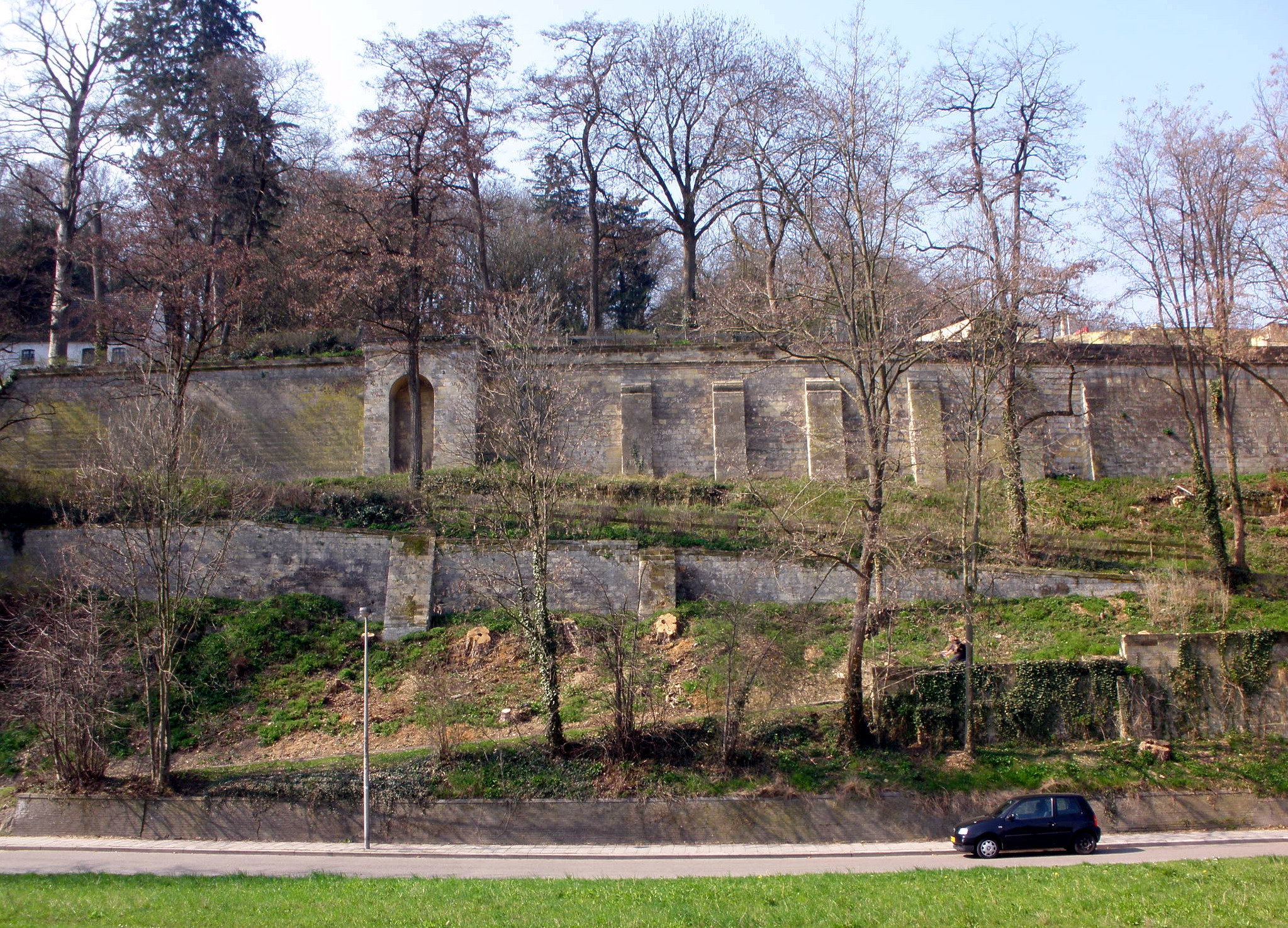
Slavante Monastery can be seen, including a small baroque chapel dedicated to Saint Anthony. Nearby, an elegant pavilion, 'Casino' Slavante, was built in 1846 by a Maastricht military gentlemen's club. A sinister reminder of World War II is the fortress Eben-Emael, constructed in 1931–35 to protect the Belgian border near the Albert Canal.
References
External links
Tourist information on website maastrichtunderground.nl
(partly in English)
Montagne Saint-Pierre
site describing the region
Tourist information on website ''Regionaal Landschap Haspengouw en Voeren''
'Sint-Pietersberg' on website ''Natuurmonumenten''
Information over quarries Mount Saint Peter on website Kevin Amendt
{{in lang, nl Plateaus of Europe Mountains and hills of the Netherlands Mountains and hills of Flanders Mountains and hills of Liège Province Landforms of Limburg (Belgium) Hills of South Limburg (Netherlands) Geography of Maastricht Visé