Columbia Plateau Aquifer System on:
[Wikipedia]
[Google]
[Amazon]
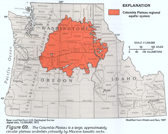
The Columbia Plateau Aquifer system is a series of layered aquifers across ~44,000 mi2 of Washington, Oregon, and Idaho. The aquifer system is on the 
Columbia Plateau
The Columbia Plateau is a geologic and geographic region that lies across parts of the U.S. states of Washington, Oregon, and Idaho. It is a wide flood basalt plateau between the Cascade Range and the Rocky Mountains, cut through by the Columbia ...
, contained within the Cascades, Rocky Mountains, Okanogan Highlands, and the Blue Mountains.Burns, Erick R., Daniel T. Snyder, Jonathan V. Haynes, and Michael S. Waibel. "Groundwater Status and Trends for the Columbia Plateau Regional Aquifer System, Washington, Oregon, and Idaho" U.S. Geological Survey Scientific Investigations Report 2012–5261, 2012. Web. These aquifers are bounded on the bottom by a layer of Miocene basaltic rock that can be up to 15,000 ft thick.Whitehead, R.L. "GROUND WATER ATLAS of the UNITED STATES
Idaho, Oregon, Washington." U.S. Geological Survey HA 730-H, 1994. Web. The primary aquifers in the system are shallow, and unconfined.

Water quality
The primary source of water quality concerns was from agricultural outputs, especially in the southwestern area of the system where land use is predominantly agricultural. As of aUSGS
The United States Geological Survey (USGS), formerly simply known as the Geological Survey, is a scientific agency of the United States government. The scientists of the USGS study the landscape of the United States, its natural resources, a ...
study on water quality in 2010, one major concern was that nitrates present in the water were exceeding the 10 mg/L standard for drinking water in 17% of the sampled wells. An additional concern was that pesticides like atrazine were often present in the water, but so far they have been detected at concentrations meeting human health standards.Frans, Lonna M., Michael G. Rupert, Charles D. Hunt, and Kenneth D. Skinner. "Groundwater Quality in the Columbia Plateau, Snake River Plain, and Oahu Basaltic-Rock and Basin-Fill Aquifers in the Northwestern United States and Hawaii, 1992-2010." U.S. Geological Survey Scientific Investigations Report 2012–5123, 2012. Web.
Water quantity
The primary use of groundwater is for crop irrigation. Areas of the plateau with high surface irrigation have less concern overgroundwater depletion
Overdrafting is the process of extracting groundwater beyond the equilibrium yield of an aquifer. Groundwater is one of the largest sources of fresh water and is found underground. Groundwater depletion is comparable to a bank account in which mor ...
due to reinfiltration of excess water into the aquifer system. Areas where groundwater depletion is a concern are in the Umatilla area, and the Palouse slope. In the Umatilla area, total decline since the 1970s is from 300 ft to 100 ft of water height. Overall, between 1968-2009, mean groundwater decline across the aquifer system was at 1.0 ft/year.
Notes
{{reflist Aquifers in the United States Northwestern United States