Carlton Vale on:
[Wikipedia]
[Google]
[Amazon]
 Carlton Vale is a street that runs through Kilburn and Maida Vale in London. Some of its route forms the boundary between the
 Carlton Vale is a street that runs through Kilburn and Maida Vale in London. Some of its route forms the boundary between the
 City of Westminster
The City of Westminster is a City status in the United Kingdom, city and London boroughs, borough in Inner London. It is the site of the United Kingdom's Houses of Parliament and much of the British government. It occupies a large area of cent ...
to the south and the London Borough of Brent
The London Borough of Brent () is a London boroughs, London borough in north-west London. It borders the boroughs of London Borough of Harrow, Harrow to the north-west, London Borough of Barnet, Barnet to the north-east, London Borough of Camden ...
to the north. To the west the street continues as Kilburn Lane
Kilburn Lane is a street in Northwest London which runs through North Kensington, London, North Kensington, London and Kilburn, London, Kilburn, London. Its route marks the boundary between the City of Westminster and the London Borough of Brent ...
through Queen's Park, while to the east it becomes Carlton Hill running into St. John's Wood
St John's Wood is a district in the City of Westminster, London, lying 2.5 miles (4 km) northwest of Charing Cross. Traditionally the northern part of the ancient parish and Metropolitan Borough of Marylebone, it extends east to west from ...
. Carlton Vale crosses or meets several roads including Kilburn Park Road, Cambridge Road and Randolph Avenue
Randolph Avenue is a street in Maida Vale in London. Located in the City of Westminster, it is a long avenue running from north to south. The southern end is located in Little Venice near to the Paddington branch of the Grand Union Canal. The st ...
.
Carlton was a popular name in the Regency era and beyond, suggesting an "ambience of elegance". The street was developed in the mid- nineteenth century and was originally known as Carlton Road. Most of the original buildings were Victorian
Victorian or Victorians may refer to:
19th century
* Victorian era, British history during Queen Victoria's 19th-century reign
** Victorian architecture
** Victorian house
** Victorian decorative arts
** Victorian fashion
** Victorian literature ...
, although few survive today. The Anglo-Catholic St. Augustine's Church was built just north of Carlton Vale to serve the growing population of the area. To the south of the street is Paddington Recreation Ground.
The street suffered heavily from German bombing during the Second World War, and was rebuilt in the postwar era with modernist buildings. Particularly notable is the South Kilburn
South Kilburn is a large housing estate in Kilburn, in the London Borough of Brent. Typical of brutalist 60's designs of public housing in the United Kingdom it is characterised by high-density housing in low-rise flats and 11 concrete tower blo ...
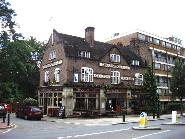
estate. The Carlton Tavern
The Carlton Tavern is a pub in Kilburn, London that was demolished in 2015 by Tel Aviv-based developer CLTX, which had failed to obtain the necessary planning permission. The council subsequently ordered the pub to be rebuilt brick by brick. It r ...
pub was built in the 1920s by the Charrington Brewery
Charrington Brewery was founded in Bethnal Green, London, in the early 18th century by Robert Westfield. In 1766, John Charrington joined the company, which then traded as Westfield, Moss & Charrington from the Anchor Brewery in Stepney. It merge ...
. Demolished in 2015 shortly before it was about to be listed, it was rebuilt in its original form and reopened in 2021.
References
Bibliography
* Bebbington, Gillian. ''London Street Names''. Batsford, 1972. * Cockburn, J. S., King, H. P. F. & McDonnell, K. G. T. & ''A History of the County of Middlesex''. Institute of Historical Research, 1989. * Cherry, Bridget & Pevsner, Nikolaus. ''London 3: North West''. Yale University Press, 2002. Streets in the City of Westminster Streets in the London Borough of Brent Kilburn, London Maida Vale {{London-road-stub