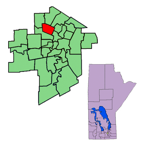
Burrows (Manitoba Riding) on:
[Wikipedia]
[Google]
[Amazon]
Burrows is a provincial electoral division in the Canadian province of

Manitoba
, image_map = Manitoba in Canada 2.svg
, map_alt = Map showing Manitoba's location in the centre of Southern Canada
, Label_map = yes
, coordinates =
, capital = Winn ...
. It was created by redistribution in 1957 from part of Winnipeg North
Winnipeg North (french: Winnipeg-Nord) is a federal electoral district in Canada that has been represented in the House of Commons of Canada since 1917. It covers the northern portion of Winnipeg, Manitoba.
Geography
The riding includes the ne ...
, and formally came into existence in the provincial election of 1958. The riding is located in the northern part of Winnipeg
Winnipeg () is the capital and largest city of the province of Manitoba in Canada. It is centred on the confluence of the Red and Assiniboine rivers, near the longitudinal centre of North America. , Winnipeg had a city population of 749, ...
.
Burrows is named after Theodore Arthur Burrows
Theodore Arthur Burrows (August 15, 1857 – January 18, 1929) was a politician and office-holder in Manitoba, Canada. He served as the tenth Lieutenant Governor of the province from October 6, 1926 until his death.
Burrows was born in ...
, who served as Lieutenant-Governor
A lieutenant governor, lieutenant-governor, or vice governor is a high officer of state, whose precise role and rank vary by jurisdiction. Often a lieutenant governor is the deputy, or lieutenant, to or ranked under a governor — a " second-in-com ...
of Manitoba from 1926 to 1929. It is bordered to the east by St. Johns and Point Douglas
Point Douglas is a provincial electoral district in Winnipeg, Manitoba, Canada. It is named for a part of the city that is surrounded by a bend in the Red River. The riding covers the neighbourhoods of William Whyte, Dufferin Industrial, Nort ...
, to the south by Wellington
Wellington ( mi, Te Whanganui-a-Tara or ) is the capital city of New Zealand. It is located at the south-western tip of the North Island, between Cook Strait and the Remutaka Range. Wellington is the second-largest city in New Zealand by metr ...
, to the north by Kildonan and The Maples, and to the west by Tyndall Park. The riding's boundaries were significantly redrawn in 1999, taking in a considerable amount of territory which was previously a part of the now-defunct Inkster.
The riding's population in 1996 was 18,718. In 1999, the average family income was $35,575, one of the lowest rates in the province. Thirty-nine per cent of the riding's residents are listed as low-income, with an unemployment rate of 13%. One household in four has only one parent. Nineteen per cent of the riding's residents are over sixty-five years of age.
The total immigrant population in Burrows is 21%, with almost one in three residents speaking a first language other than English or French. The Aboriginal population is 15%.
Manufacturing accounts for 22% of Burrows' industry, with a further 15% in the service sector.
The CCF and its successor the NDP
NDP may stand for:
Computing
* Neighbor Discovery Protocol, an Internet protocol
* Nortel Discovery Protocol, a layer two Internet protocol, also called SONMP
* Nondeterministic programming, a type of computer language
Government
* National ...
have won Burrows on all but three occasions since the riding was created, with the Liberals winning the other three elections.
List of provincial representatives
Electoral results
Previous boundaries

References
{{Coord, 49.93, N, 97.17, W, display=title Manitoba provincial electoral districts Politics of Winnipeg