Birdforth on:
[Wikipedia]
[Google]
[Amazon]
Birdforth is a village and
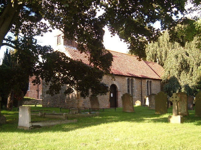
 St Mary's Church, Birdforth is a
civil parish
In England, a civil parish is a type of administrative parish used for local government. It is a territorial designation which is the lowest tier of local government below districts and counties, or their combined form, the unitary authority ...
in the Hambleton district of North Yorkshire
North Yorkshire is the largest ceremonial counties of England, ceremonial county (lieutenancy area) in England, covering an area of . Around 40% of the county is covered by National parks of the United Kingdom, national parks, including most of ...
, England. According to the 2001 census it had a population of 13. The population remained less than 100 at the 2011 Census. Details are included in the civil parish of Long Marston, North Yorkshire
Long Marston is a village and civil parish in the Harrogate district of North Yorkshire, England. Historically part of the West Riding of Yorkshire, it is situated on the B1224 road from Wetherby to York, west of York. The civil parish inc ...
. The village is on the A19 road
The A19 is a major road in England running approximately parallel to and east of the A1 road. Although the two roads meet at the northern end of the A19, the two roads originally met at the southern end of the A19 in Doncaster, but the old ...
, about six miles south of Thirsk
Thirsk is a market town and civil parish in the Hambleton district of North Yorkshire, England known for its racecourse; quirky yarnbomber displays, and depiction as local author James Herriot's fictional Darrowby.
History
Archeological fin ...
.
History
Birdforth was also the name of one of thewapentakes
A hundred is an administrative division that is geographically part of a larger region. It was formerly used in England, Wales, some parts of the United States, Denmark, Southern Schleswig, Sweden, Finland, Norway, the Bishopric of Ösel–Wiek ...
, or subdivisions, of the North Riding of Yorkshire
The North Riding of Yorkshire is a subdivision of Yorkshire, England, alongside York, the East Riding and West Riding. The riding's highest point is at Mickle Fell with 2,585 ft (788 metres).
From the Restoration it was used as ...
, which covered the area around the village. A school was built in 1875, but closed in 1961.
Governance
The village lies within the Thirsk and Malton UK Parliament constituency. It is also within theEasingwold
Easingwold is a market town, electoral ward and civil parish in the Hambleton District in North Yorkshire, England. Historically, part of the North Riding of Yorkshire, it had a population of 4,233 at the 2001 census, increasing to 4,627 at t ...
electoral division of North Yorkshire County Council and the Helperby
Helperby is a village and former civil parish, now in the parish of Brafferton and Helperby, in the Hambleton District of North Yorkshire, England, about five miles west of Easingwold. Over the years it has joined onto Brafferton, North Yorksh ...
ward of Hambleton District Council.
Geography
The nearest settlements to the village areHutton Sessay
Hutton Sessay is a village and civil parish in the Hambleton district of North Yorkshire, England. In 2013 the population of the civil parish was estimated at 100. In recent censuses the population of Hutton Sessay has been included with Sess ...
to the north-west; Carlton Husthwaite
Carlton Husthwaite is a village and civil parish in the Hambleton district of North Yorkshire, England, about seven miles south-east of Thirsk. According to the 2001 census it had a population of 167, increasing to 180 at the 2011 Census.
Hi ...
to the north-east and Thormanby
Thormanby is a village and civil parish in Hambleton District of North Yorkshire, England. It lies on the A19 approximately halfway between Easingwold and Thirsk and about south east of the county town of Northallerton.
History
Thormanby ...
to the south. Birdforth Beck, which flows at the south end of the village, is part of the tributary system of the River Swale
The River Swale in Yorkshire, England, is a major tributary of the River Ure, which becomes the River Ouse, that empties into the North Sea via the Humber Estuary. The river gives its name to Swaledale, the valley through which it flows.
Th ...
.
The 1881 UK Census recorded the population as 42.
Religion
 St Mary's Church, Birdforth is a
 grade II listed
In the United Kingdom, a listed building or listed structure is one that has been placed on one of the four statutory lists maintained by Historic England in England, Historic Environment Scotland in Scotland, in Wales, and the Northern Irel ...
Norman church; it was partly rebuilt in 1585, but is no longer in use.
References
Villages in North Yorkshire Civil parishes in North Yorkshire {{Hambleton-geo-stub