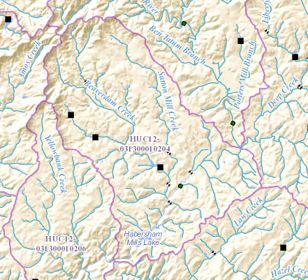
Beaverdam Creek (Soque River) on:
[Wikipedia]
[Google]
[Amazon]
Beaverdam Creek is a stream in

 Beaverdam Creek rises in northwestern
Soque River Watershed Association
{{Authority control Rivers of Georgia (U.S. state) Rivers of Habersham County, Georgia
Georgia
Georgia most commonly refers to:
* Georgia (country), a country in the Caucasus region of Eurasia
* Georgia (U.S. state), a state in the Southeast United States
Georgia may also refer to:
Places
Historical states and entities
* Related to the ...
, and is a tributary of the Soque River
The Soque River (Cherokee: ᏐᏈ) (Soquee River per 1972 Board on Geographic Names decision) and its watershed are located entirely within the county boundaries of Habersham County in northeast Georgia. The Soque is a tributary of the Chattahoo ...
. The creek is approximately long. file geodatabase (GDB) at ftp://rockyftp.cr.usgs.gov/vdelivery/Datasets/Staged/Hydro/FileGDB101/
Course
Habersham County
Habersham County is a County (United States), county located in the Northeast Georgia, northeastern part of the U.S. state of Georgia (U.S. state), Georgia. As of the 2010 United States Census, 2010 census, the population was 43,041. The county s ...
, Georgia
Georgia most commonly refers to:
* Georgia (country), a country in the Caucasus region of Eurasia
* Georgia (U.S. state), a state in the Southeast United States
Georgia may also refer to:
Places
Historical states and entities
* Related to the ...
, northwest of Clarkesville and south of the Shoal Creek/Upper Soque River sub-watershed, and runs largely in a southeasterly direction for approximately , picking up the waters of several small, unnamed branches. Less than east of the intersection of State Route 17 and State Route 115, Beaverdam Creek is joined by Sutton Mill Creek, which originates not far from the source of Beaverdam Creek. The creek then crosses State Route 17/115, and flows into the Soque River
The Soque River (Cherokee: ᏐᏈ) (Soquee River per 1972 Board on Geographic Names decision) and its watershed are located entirely within the county boundaries of Habersham County in northeast Georgia. The Soque is a tributary of the Chattahoo ...
just west of Clarkesville, and just north of Habersham Mills Lake.
Sub-watershed details
The creek watershed and associated waters is designated by theUnited States Geological Survey
The United States Geological Survey (USGS), formerly simply known as the Geological Survey, is a scientific agency of the United States government. The scientists of the USGS study the landscape of the United States, its natural resources, ...
as sub- watershed HUC 031300010204, is named the Middle Soque River sub-watershed, and drains an area of approximately northwest of Clarkesville, as well as northwest of the Soque River.
See also
* Water Resource Region *South Atlantic-Gulf Water Resource Region
South is one of the cardinal directions or compass points. The direction is the opposite of north and is perpendicular to both east and west.
Etymology
The word ''south'' comes from Old English ''sūþ'', from earlier Proto-Germanic ''*sunþaz ...
*Apalachicola basin
The ACF River Basin is the drainage basin, or watershed, of the Apalachicola River, Chattahoochee River, and Flint River, in the Southeastern United States.
This area is alternatively known as simply the Apalachicola Basin and is listed by t ...
References
External links
Soque River Watershed Association
{{Authority control Rivers of Georgia (U.S. state) Rivers of Habersham County, Georgia