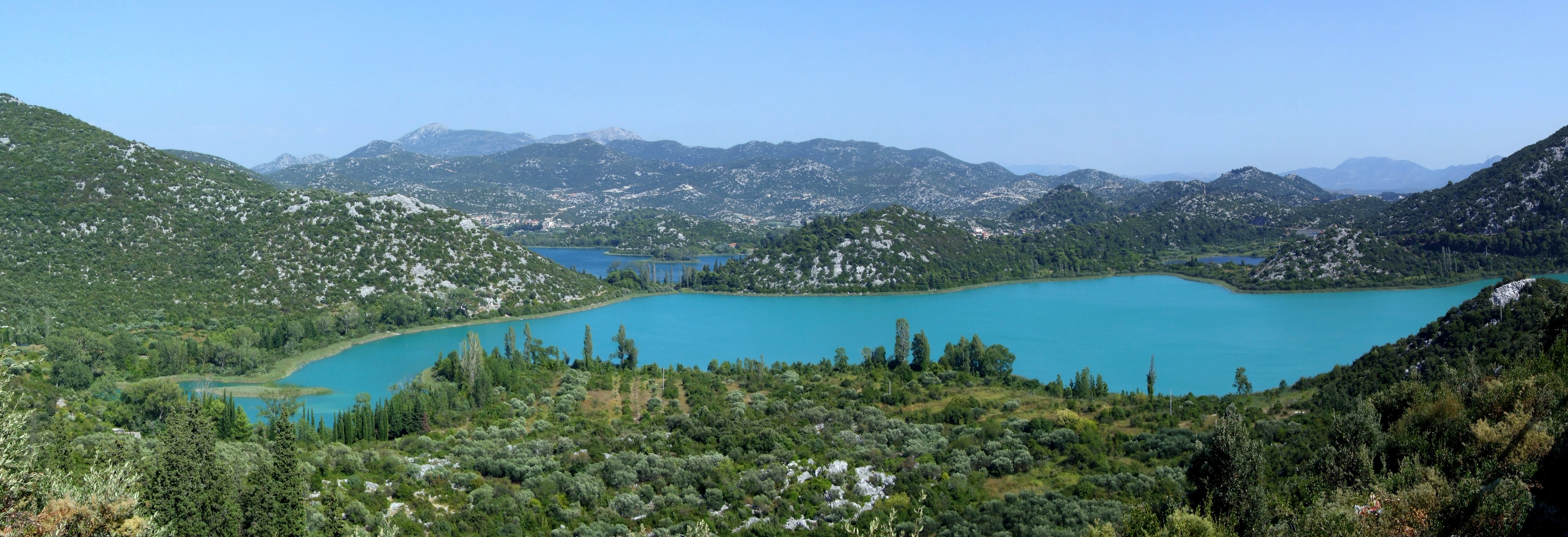
Baćina Lakes on:
[Wikipedia]
[Google]
[Amazon]
 The Baćina lakes ( hr, Baćinska jezera) are located in
www.bacina.com
{{DEFAULTSORT:Bacina Lakes Lake groups of Croatia Landforms of Dubrovnik-Neretva County LBaćina
 The Baćina lakes ( hr, Baćinska jezera) are located in
 Dalmatia
Dalmatia (; hr, Dalmacija ; it, Dalmazia; see #Name, names in other languages) is one of the four historical region, historical regions of Croatia, alongside Croatia proper, Slavonia, and Istria. Dalmatia is a narrow belt of the east shore of ...
, Croatia
, image_flag = Flag of Croatia.svg
, image_coat = Coat of arms of Croatia.svg
, anthem = "Lijepa naša domovino"("Our Beautiful Homeland")
, image_map =
, map_caption =
, capit ...
. The lakes are named after the inland town of Baćina close to the port city of Ploče. The lakes are part of a picturesque landscape and surrounded by mountains. They are situated between Makarska
Makarska (; it, Macarsca, ; german: Macharscha) is a town on the Adriatic coastline of Croatia, about southeast of Split (city), Split and northwest of Dubrovnik, in the Split-Dalmatia County.
Makarska is a prominent regional tourist center, ...
and Dubrovnik
Dubrovnik (), historically known as Ragusa (; see notes on naming), is a city on the Adriatic Sea in the region of Dalmatia, in the southeastern semi-exclave of Croatia. It is one of the most prominent tourist destinations in the Mediterran ...
. It is a crypto-depression lake, with its bottom below the surface of the sea.
Description
Despite its proximity to the sea and the permeable nature of the karst area, they are fresh water lakes. The seven lakes cover an area of 138hectares
The hectare (; SI symbol: ha) is a non-SI metric unit of area equal to a square with 100-metre sides (1 hm2), or 10,000 m2, and is primarily used in the measurement of land. There are 100 hectares in one square kilometre. An acre is ab ...
and they are named Oćuša, Crniševo, Podgora, Sladinac, Vrbnik, Šipak and Plitko. Six of these lakes are linked. The only isolated lake is Vrbnik.The largest lake is Oćuša and the deepest is the Crniševo (34 m). The lakes are connected with the sea and at times the water can be brackish
Brackish water, sometimes termed brack water, is water occurring in a natural environment that has more salinity than freshwater, but not as much as seawater. It may result from mixing seawater (salt water) and fresh water together, as in estuari ...
, also the surface of the lakes lies 80 cm above sea level. Salty water is found at the bottom of the deepest lake Crnisevo.
Lake Vrgorac ( hr, Vrgorsko jezero) located to the north of the Baćina lakes drains into the Adriatic Sea
The Adriatic Sea () is a body of water separating the Italian Peninsula from the Balkan Peninsula. The Adriatic is the northernmost arm of the Mediterranean Sea, extending from the Strait of Otranto (where it connects to the Ionian Sea) to t ...
through them.
At the turn of the century the Austro-Hungarian
Austria-Hungary, often referred to as the Austro-Hungarian Empire,, the Dual Monarchy, or Austria, was a constitutional monarchy and great power in Central Europe between 1867 and 1918. It was formed with the Austro-Hungarian Compromise of ...
government built a tunnel to the sea. This led to the lowering of the lake level which has brought about biological changes. The tunnel currently runs underneath the Adriatic Highway.
In recent times the lake has become a well-known hunting ground for grey mullet Grey mullet can mean any of several fish in the family ''Mugilidae'' (the mullets) and having a greyish hue:
* Flathead grey mullet, ''Mugil cephalus''
* Thicklip grey mullet, ''Chelon labrosus''
* Boxlip grey mullet, ''Oedalechilus labeo''
* Leapi ...
(Mugil saliens).
See also
*References
External links
www.bacina.com
{{DEFAULTSORT:Bacina Lakes Lake groups of Croatia Landforms of Dubrovnik-Neretva County LBaćina