Baihata Railway Station on:
[Wikipedia]
[Google]
[Amazon]
Baihata Chariali (Pron: baɪˈhɑ:tə ˈʧɑ:rɪˌɑ:lɪ) is an out growth urban centre of Guwahati City in

Kamrup Rural district
Kamrup Rural district, or simply Kamrup district (Pron: ˈkæmˌrəp or ˈkæmˌru:p), is an administrative district in the state of Assam in India formed by dividing the old Kamrup district into two in the year 2003; other being Kamrup Metrop ...
of Assam
Assam (; ) is a state in northeastern India, south of the eastern Himalayas along the Brahmaputra and Barak River valleys. Assam covers an area of . The state is bordered by Bhutan and Arunachal Pradesh to the north; Nagaland and Manipur ...
, India; situated at norther site of the river Brahmaputra
The Brahmaputra is a trans-boundary river which flows through Tibet, northeast India, and Bangladesh. It is also known as the Yarlung Tsangpo in Tibetan, the Siang/Dihang River in Arunachali, Luit in Assamese, and Jamuna River in Bangla. It ...
. The place is called Chariali as it is a major road junction where National Highway 27 interconnect with National Highway 15.
Etymology
The 'Chariali' was suffixed to its name later due be a junction of four roads at its town square, including National highway 27 andNational Highway 15
Route 15, or Highway 15, can refer to:
For roads named A15, see A15 roads.
International
* Asian Highway 15
* European route E15
* European route E015
Australia New South Wales
* Hunter Expressway
* New England Highway and other local Newcas ...
.
Education
Delhi Public School, Kamrup is situated here. The 'Pub Kamrup college' is a well known college of entire district which is located here in Goreswar road. State government recently constructed a polytechnic college named Kamrup Polytechnic. There are a few private colleges for 10+2 studies. Some of them are Gateway Academy Junior College, Ramanujan Academy and Jenith Academy.Place of interest
Madan Kamdev
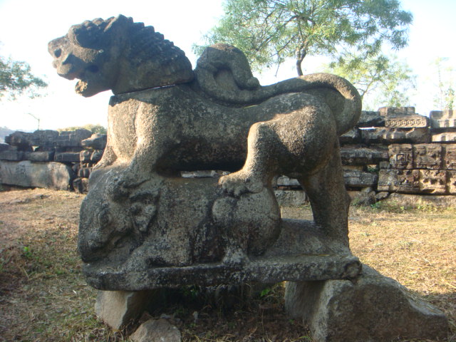
Madan Kamdev (Pron: ˈmʌdən/məˈdɑ:n kæmˈdeɪv/ˈkʌmˌdeɪv) is an archaeological site in Baihata Chariali, Kamrup, Assam. The place dates back to the 9th and 10th century A.D. The excavation and ruins is dated back to the Pala dynasty of ...
archeological site built by Pala dynasty
The Pāla Empire (r. 750-1161 CE) was an imperial power during the post-classical period in the Indian subcontinent, which originated in the region of Bengal. It is named after its ruling dynasty, whose rulers bore names ending with the suffi ...
of Kamrup Kingdom
Kamarupa (; also called Pragjyotisha or Pragjyotisha-Kamarupa), an early state during the Classical period on the Indian subcontinent, was (along with Davaka) the first historical kingdom of Assam.
Though Kamarupa prevailed from 350 to 11 ...
is located here.
The noteworthy Gopeshwar temple of village Deuduar
Deuduar is a mid-sized village located in the district of Kamrup in the state of Assam in India. It has a population of about 3500 persons living in around 300 households. It is situated almost 30 km away Guwahati. The 31 natioanal highway ...
situated near the town. Radha Kuchi
Radha Kuchi is a village near the town of Baihata, Kamrup district, Assam, India.
Location
Radha Kuchi is about 1 kilometer away from the Indian town of Baihata. Nanara, Aagdola and Nagaon are the neighboring villages of Radha Kuchi. It b ...
is situated in the north of Baihata.
Transport
Baihata Chariali is situated at National Highway 27 and is well connected with nearby towns like Rangia,Nalbari
Nalbari (Pron: nɔ:lˈbɑ:rɪ) is a town and a municipal board in Nalbari district in the Indian States and territories of India, state of Assam. Nalbari town is also the headquarters of Nalbari district, Nalbari District. The town is one of ma ...
and Guwahati
Guwahati (, ; formerly rendered Gauhati, ) is the biggest city of the Indian state of Assam and also the largest metropolis in northeastern India. Dispur, the capital of Assam, is in the circuit city region located within Guwahati and is the ...
with road and Railways. The National Highway 15 is connecting Baihata Chariali to the Eastern Assam via Tezpur. It is about half hour away from Guwahati. The Baihata Railway Station is at a distance of only 3 km from the town Center.
See also
* Kamalpur *Bijoynagar
Bijoynagar is a town in the Kamrup district. It is on the south bank of the river Brahmaputra.
Transport
Bijoynagar is located on National Highway 17 and is well together with Guwahati and other nearby towns with both government and private c ...
References
{{reflist Cities and towns in Kamrup district