Bagnan on:
[Wikipedia]
[Google]
[Amazon]
Mama Saha Bagnan is a

Bagnan
{Howrah District Cities and towns in Howrah district
census town
In India and some other countries, a census town is designated as a town that satisfies certain characteristics.
India
In India, a census town is one which is not statutorily notified and administered as a town, but nevertheless whose population ...
in Bagnan I
Bagnan I is a community development block (CD Block) that forms an administrative division in Uluberia subdivision of Howrah district in the Indian state of West Bengal.
Geography
Location
Kalyanpur, a constituent panchayat of Bagnan I block, i ...
CD Block of Uluberia subdivision
Uluberia subdivision is a subdivision of the Howrah district in the state of West Bengal, India. It consists of Uluberia municipality and nine community development (CD) blocks, including 90 gram panchayats and six census towns. The six census ...
in Howrah district
Howrah district (, ) is a district of the West Bengal state in eastern India. Howrah district is one of the highly urbanized area of West Bengal. The urbanised sectors gradually increase the slum populations. Howrah is the third smallest distric ...
in the state of West Bengal
West Bengal (, Bengali: ''Poshchim Bongo'', , abbr. WB) is a state in the eastern portion of India. It is situated along the Bay of Bengal, along with a population of over 91 million inhabitants within an area of . West Bengal is the fourt ...
, India.
Geography
Bagnan is located at . It has an average elevation of 6 metres (19 feet). It is situated between two rivers, the Damodar and the Rupnarayan.Demographics
As per2011 Census of India
The 2011 Census of India or the 15th Indian Census was conducted in two phases, house listing and population enumeration. The House listing phase began on 1 April 2010 and involved the collection of information about all buildings. Information ...
Bagnan had a total population of 10,996 of which 5,536 (50%) were males and 5,460 (50%) were females. Population below 6 years was 1,226. The total number of literates in Bagnan was 8,388 (85.85% of the population over 6 years).
India census
A census is the procedure of systematically acquiring, recording and calculating information about the members of a given population. This term is used mostly in connection with national population and housing censuses; other common censuses incl ...
, Bagnan had a population of 8,779. Males constitute 51% of the population and females 49%. Bagnan has an average literacy rate of 68%, higher than the national average of 59.5%; with 55% of the males and 45% of females literate. 12% of the population is under 6 years of age.
Education

High schools
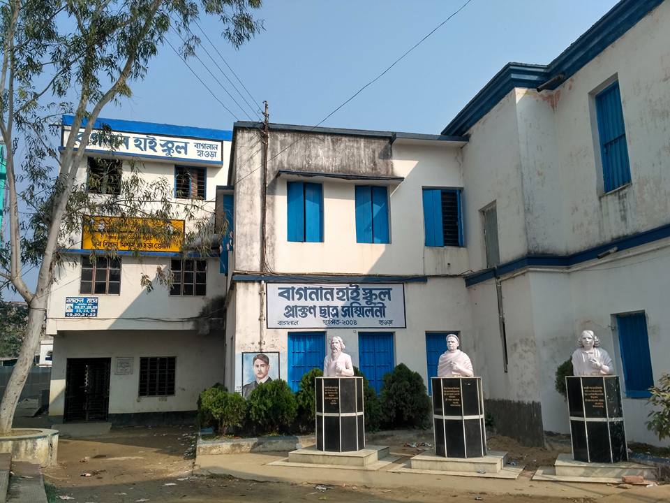
*Bagnan High School
Bagnan High School, known informally as BHS or Bagnan Boys' High School, is a school in Bagnan in the Howrah District of West Bengal. The school is located near the local railway and police stations, and the registry office. This school is the fi ...
; established in 1854
* St. Xavier's Public School
* Bagnan Adarsha Balika Vidyalaya; girls school, established in 1964
* Santoshpur Gauranga Vidyapith, established in 1957.
* Mugkalyan High School; in Mugkalyan, established 1866.
* Benapur Chandanapara High School(H.S)
* Bantul Mahakali High School; established at 1916.
* Chandravag Srikrishna Girl's High School
* Bagnan Girls' High School
* Tenpur Nabasan Anantaram High School
* Nabasan High School
* Khalore Gopimohan Shikshayataan
* Kalyanpur High School (H.S.)
*Bangalpur U. C High SCHOOL (H. S.)
*B.N.S. High School
*Bangalpur Jyotirmoyee Girls' High School
*Deulgram Mankur Bakshi High school
Pre-Primary/KG School
* Bagnan Primary School (Govt), O.T road, near Telephone exchange * Khalore Kali bari Primary School(Govt), Beside Khalore Maa Kali temple. * St. Thomas school(Pvt), near registry office, Bagnan * Notobor memorial Kindergarten School (Pvt.), Chandrapur * Children's academy(Pvt), near Block Agri office * Swami Vivekananda School(Pvt), Khalore * Path Bhawan(Pvt), near Khalore Maa Kali Temple. * Little Millennium Pre primary(Pvt) - Near Bagnan-II BD Office, Kolapara Kamarshal. * Chandanapara Children's Academy(Pvt)Colleges/Universities
There is no University located in Bagnan but there is a College. *Bagnan College
Bagnan College is an undergraduate liberal arts college in Bagnan, West Bengal, India. It is situated in Howrah district, and is affiliated with the University of Calcutta.
Departments Science
*Chemistry
*Physics
*Mathematics
*Botany
*Zoolog ...
is affiliated to University of Calcutta. The college was founded in July 1958 with only arts faculty. In 1966 the faculty of commerce and in 1974 the faculty of science faculty was added. The college is accredited by the NAAC with B-grade since 2005.
Culture
Khalore Kali Bari Mandir in Bagnan, Howrah is one of the famous Hindu Temples in Khalore, Bagnan, Howrah, where people from all over Howrah come to worship the Goddess KALIDeulti
Deulti is located on the banks of the river Rupnarayan. This place is a tourist destination. Its distance from Kolkata is 50 kilometers. The immortal storyteller Sarat Chandra Chattopadhyay's house is there. This is also the reason for the attraction.The railway station
One of the key features of Bagnan is its railway station. It is by far one of the busiest railway station inSouth Eastern Railway Zone
The South Eastern Railway (abbreviated SER) is one of the 19 railway zones in India and Part of Eastern Railways. It is headquartered at Garden Reach, Kolkata, West Bengal, India. It comprises Adra railway division, Chakradharpur railway divis ...
within West Bengal
West Bengal (, Bengali: ''Poshchim Bongo'', , abbr. WB) is a state in the eastern portion of India. It is situated along the Bay of Bengal, along with a population of over 91 million inhabitants within an area of . West Bengal is the fourt ...
due to its connectivity to other major places
Station code : BZN
No. of Platforms : 5 (North to south)
References
Web site that provide information abouBagnan
{Howrah District Cities and towns in Howrah district