Arizona Sun Corridor on:
[Wikipedia]
[Google]
[Amazon]
The Arizona Sun Corridor, shortened Sun Corridor, is a

 The Arizona Sun Corridor lies in the
megaregion
A megalopolis () or a supercity, also called a megaregion, is a group of metropolitan areas which are perceived as a continuous urban area through common systems of transport, economy, resources, ecology, and so on. They are integrated enoug ...
, or megapolitan area, in the southern area of the U.S. state of Arizona
Arizona ( ; nv, Hoozdo Hahoodzo ; ood, Alĭ ṣonak ) is a state in the Southwestern United States. It is the 6th largest and the 14th most populous of the 50 states. Its capital and largest city is Phoenix. Arizona is part of the Fou ...
. The Sun Corridor is comparable to Indiana
Indiana () is a U.S. state in the Midwestern United States. It is the 38th-largest by area and the 17th-most populous of the 50 States. Its capital and largest city is Indianapolis. Indiana was admitted to the United States as the 19th ...
in both size and population. It is one of the fastest growing conurbation
A conurbation is a region comprising a number of metropolises, cities, large towns, and other urban areas which through population growth and physical expansion, have merged to form one continuous urban or industrially developed area. In most cas ...
s in the country and is speculated to double its population by 2040. The largest metropolitan areas are the Phoenix metropolitan area
The Phoenix Metropolitan Area – also the Valley of the Sun, the Salt River Valley, or Metro Phoenix (known by most locals simply as “the Valley”) – is the largest metropolitan area in the Southwestern United States, centered on the city ...
– Valley of the Sun, and the Tucson metropolitan area – The Old Pueblo. The regions' populace is nestled in the valley of a desert environment. Similar to Southern California
Southern California (commonly shortened to SoCal) is a geographic and cultural region that generally comprises the southern portion of the U.S. state of California. It includes the Los Angeles metropolitan area, the second most populous urban ...
, the urban area extends into Mexico, reaching the communities of Nogales and Agua Prieta
Agua Prieta (English: ''Dark Water'', Opata: ''Bachicuy'') is a town in Agua Prieta Municipality in the northeastern corner of the Mexican state of Sonora. It stands on the Mexico–U.S. border, adjacent to the town of Douglas, Arizona. The mu ...
.
Its population is composed of five metropolitan areas: Phoenix, Tucson
, "(at the) base of the black ill
, nicknames = "The Old Pueblo", "Optics Valley", "America's biggest small town"
, image_map =
, mapsize = 260px
, map_caption = Interactive map ...
, Prescott, Sierra Vista-Douglas and Nogales. Of these, two are metropolitan areas with over 1,000,000 residents: the Phoenix metropolitan area
The Phoenix Metropolitan Area – also the Valley of the Sun, the Salt River Valley, or Metro Phoenix (known by most locals simply as “the Valley”) – is the largest metropolitan area in the Southwestern United States, centered on the city ...
with 4.85 million residents and the Tucson
, "(at the) base of the black ill
, nicknames = "The Old Pueblo", "Optics Valley", "America's biggest small town"
, image_map =
, mapsize = 260px
, map_caption = Interactive map ...
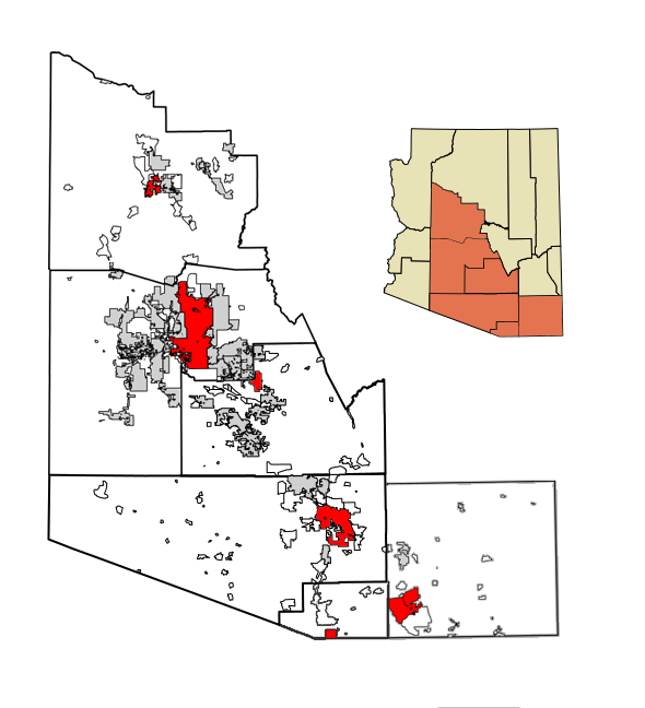
metropolitan area with over 1 million residents. The Arizona Sun Corridor is made up of all of Maricopa, Pinal and Pima counties, along with parts of Yavapai, Santa Cruz and Cochise counties. It is home to over 86 percent of Arizona's population.
Most of the Arizona Sun Corridor is in the Sonoran Desert
The Sonoran Desert ( es, Desierto de Sonora) is a desert in North America and ecoregion that covers the northwestern Mexican states of Sonora, Baja California, and Baja California Sur, as well as part of the southwestern United States (in Ariz ...
. To the south of the region is the border between the United States and Mexico, and to the north and east is the Arizona transition zone
The Arizona transition zone is a diagonal northwest-by-southeast region across central Arizona. The region is a transition from the higher-elevation Colorado Plateau in Northeast Arizona and the Basin and Range region of lower-elevation desert ...
and the Mountains of Arizona
Arizona is a landlocked state situated in the southwestern region of the United States of America. It has a vast and diverse geography famous for its deep canyons, high- and low-elevation deserts, numerous natural rock formations, and volcanic ...
. The Southern California Megaregion is to the west and is the nearest other Megaregion to the Arizona Sun Corridor.
Extent

 The Arizona Sun Corridor lies in the
 American Southwest
The Southwestern United States, also known as the American Southwest or simply the Southwest, is a geographic and cultural region of the United States that generally includes Arizona, New Mexico, and adjacent portions of California, Colorado ...
, about halfway between the Southern California
Southern California (commonly shortened to SoCal) is a geographic and cultural region that generally comprises the southern portion of the U.S. state of California. It includes the Los Angeles metropolitan area, the second most populous urban ...
and Front Range
The Front Range is a mountain range of the Southern Rocky Mountains of North America located in the central portion of the U.S. State of Colorado, and southeastern portion of the U.S. State of Wyoming. It is the first mountain range encountered ...
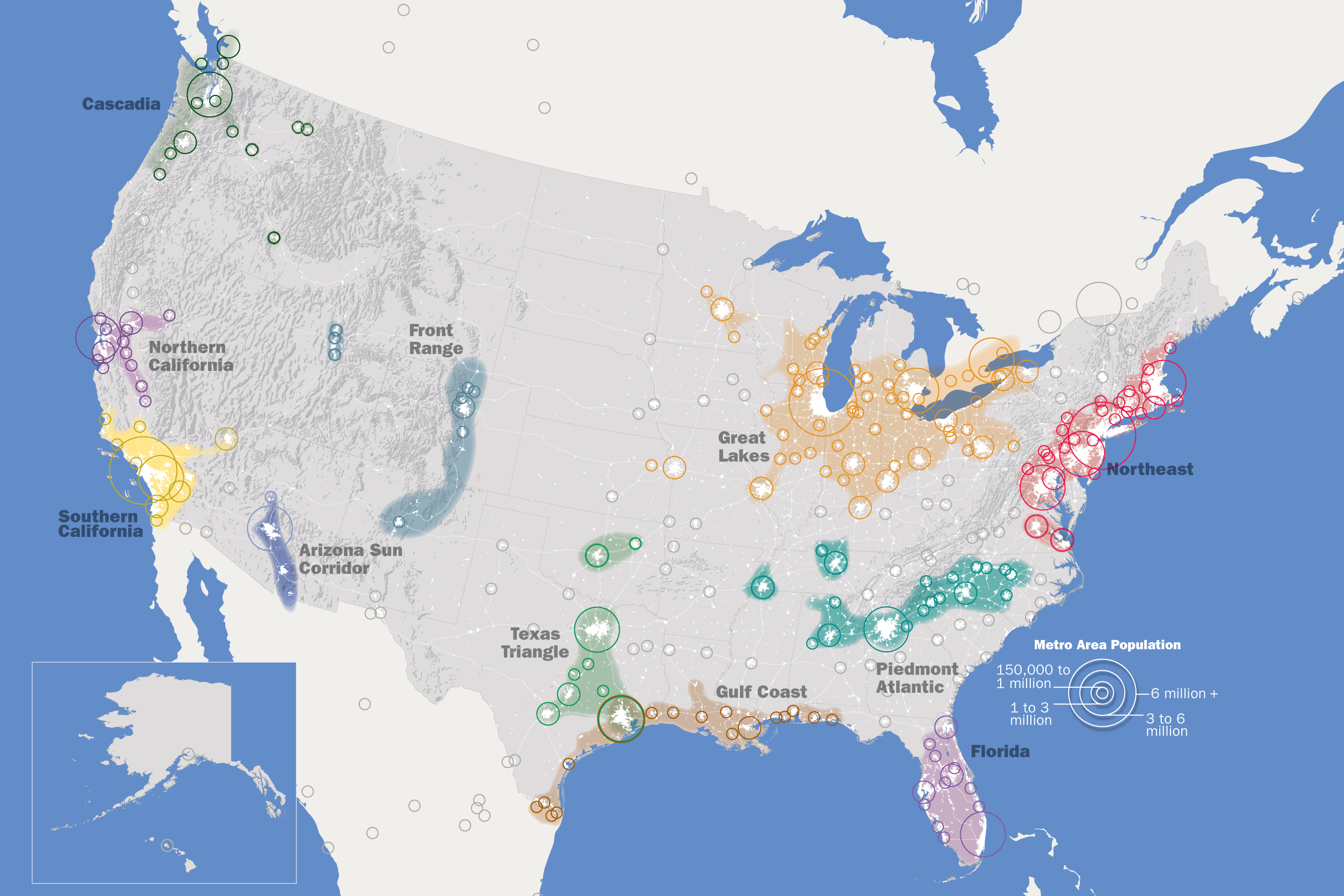
Megaregions. It is shown on the map in deep blue.
Below is a table listing all communities of the Arizona Sun Corridor with a population of at least 10,000 residents.
Transportation
Road
Intercity in the region is provided by the I-8,I-10
Interstate 10 (I-10) is the southernmost cross-country highway in the American Interstate Highway System. I-10 is the fourth-longest Interstate in the United States at , following I-90, I-80, and I-40. This freeway is part of the originally p ...
, I-17, and I-19 freeways, as well as US 60
U.S. Route 60 is a major east–west United States highway, traveling from southwestern Arizona to the Atlantic Ocean coast in Virginia.
The highway's eastern terminus is in Virginia Beach, Virginia, where it is known as Pacific Avenue, in the ...
, SR 87, SR 90, and SR 77, among other surface highways.
Phoenix area arterials are set up in a grid pattern, which helps simplify transportation within the region. Tucson's streets have a similar system.
Rail
Amtrak
The National Railroad Passenger Corporation, doing business as Amtrak () , is the national passenger railroad company of the United States. It operates inter-city rail service in 46 of the 48 contiguous U.S. States and nine cities in Canada. ...
's Sunset Limited
The ''Sunset Limited'' is an Amtrak passenger train that for most of its history has operated between New Orleans and Los Angeles, over the nation's second transcontinental route. However, up until Hurricane Katrina in 2005, it operated betw ...
operates three times a week, connecting Maricopa, Arizona
Maricopa is a city in the Gila River Valley in Pinal County, Arizona, United States. With 62,720 residents as of 2021, Maricopa is the largest incorporated municipality in Pinal County
History
Maricopa has had three locations over the years: ...
and Tucson. There is no other intercity rail in the region; however a high-speed rail corridor is also being studied between Phoenix and Tucson.
Intracity rail systems include the Valley Metro Rail
Valley Metro Rail (styled as METRO) is a light rail line serving the cities of Phoenix, Tempe, and Mesa in Arizona, USA. The network, which is part of the Valley Metro public transit system, began operations on December 27, 2008. In , the sy ...
, which operates within the Phoenix metropolitan area, connecting Uptown and Downtown Phoenix with Tempe and Mesa, and Tucson's Sun Link streetcar system, which links Downtown Tucson and the Mercado district to the University of Arizona
The University of Arizona (Arizona, U of A, UArizona, or UA) is a Public university, public Land-grant university, land-grant research university in Tucson, Arizona. Founded in 1885 by the 13th Arizona Territorial Legislature, it was the first ...
.
Air
Phoenix Sky Harbor International Airport
Phoenix Sky Harbor International Airport is a civil–military public airport east of downtown Phoenix, in Maricopa County, Arizona, United States. It is Arizona's largest and busiest airport, and among the largest commercial airports in t ...
and Tucson International Airport
Tucson International Airport is a civil-military airport owned by the City of Tucson
south of downtown Tucson, in Pima County, Arizona, United States. It is the second busiest airport in Arizona, after Phoenix Sky Harbor International Airp ...
provide air transportation to the region, from both within the country and from a few foreign countries, among other smaller airports, which focus on regional air traffic from nearby. Recently, Phoenix-Mesa Gateway Airport, previously being a military base, has also become an option for low-cost carriers to fly into the Phoenix area as well.
US Airways
US Airways (formerly USAir) was a major United States airline that operated from 1937 until its merger with American Airlines in 2015. It was originally founded in Pittsburgh as a mail delivery airline called All American Aviation, which soon ...
, now owned by Fort Worth company American Airlines
American Airlines is a major US-based airline headquartered in Fort Worth, Texas, within the Dallas–Fort Worth metroplex. It is the largest airline in the world when measured by fleet size, scheduled passengers carried, and revenue passeng ...
, was once headquartered and based in Tempe after a reverse-merger from America West Airlines
America West Airlines was a major American airline, founded in 1981, with service commencing in 1983, and having reached US$1 billion in annual revenue in 1989, headquartered in Tempe, Arizona. At the time of its acquisition of US Airways, Amer ...
in 2005, headquarters of which is in the Phoenix Valley. However, American Airlines maintains a strong presence in the state due to the history with US Airways.
References
{{Arizona Geography of Arizona Regions of Arizona Megapolitan areas of the United States