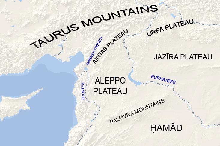
Aintab plateau on:
[Wikipedia]
[Google]
[Amazon]
 Aintab plateau or Gaziantep plateau ( ar, هضبة عنتاب
 Aintab plateau or Gaziantep plateau ( ar, هضبة عنتاب
 Levantine Levantine may refer to:
* Anything pertaining to the Levant, the region centered around modern Syria, Lebanon, Israel, Palestine, and Jordan, including any person from the Levant
** Syria (region), corresponding to the modern countries of the Lev ...
pronunciation: ) is a low, gently undulating plateau that forms the westernmost part of the Southeastern Anatolia Region in Turkey. It forms the northwestern end of the Arabian Plate where it meets the Anatolian Plate
The Anatolian Plate is a continental tectonic plate comprising most of the Anatolia (Asia Minor) peninsula (and the country of Turkey).
To the east, the East Anatolian Fault, a left lateral transform fault, forms a boundary with the Arabian Pla ...
at the East Anatolian Fault. The plateau lies in the Turkish provinces of Gaziantep, Kilis
Kilis is a city in south-central Turkey, near the Syria–Turkey border, border with Syria, and the administrative centre of Kilis Province.
History
Although there aren't any definite information related to its foundation, today's Kilis mainl ...
, and Adıyaman. In Classical Antiquity, this was the region of Commagene. Gaziantep (Aintab) is located nearly in the south-center of the plateau.
Borders and description
The average elevation of the Aintab plateau is 400–600 m in the south and 600–700 m in the northern Adıyaman Province. The plateau forms the northernmost part of the Syria geographic region. Aintab plateau is a continuation ofAleppo plateau
The Aleppo plateau ( ar, هضبة حلب ) is a low, gently undulating plateau of northern Syria. It lies at the northern end of the junction between the Arabian Plate and the African Plate at the Dead Sea Rift. The plateau lies mostly in the Ale ...
; Aleppo plateau slopes upward gently in a southeast-northwest direction and then it rises forming the Aintab plateau approximately midway between Aleppo
)), is an adjective which means "white-colored mixed with black".
, motto =
, image_map =
, mapsize =
, map_caption =
, image_map1 =
...
and Gaziantep. Mount Kurd, Mount Simeon
Mount Simeon or Mount Simon ( ar, جبل سمعان Jabal Simʻān ), also called Mount Laylūn ( ar, جبل ليلون, is a highland region in Aleppo Governorate in northern Syria. The mountain is located in the Mount Simeon and Aʻzāz distric ...
, and Mount ʻAqīl are extensions of Aintab plateau into Aleppo plateau.
Aintab plateau is bounded from the east by the valley of River Euphrates
The Euphrates () is the longest and one of the most historically important rivers of Western Asia. Tigris–Euphrates river system, Together with the Tigris, it is one of the two defining rivers of Mesopotamia ( ''the land between the rivers'') ...
and the Manbij plain
Manbij plain ( ar, سهل منبج ) is a vast plain on the eastern Aleppo plateau in northern Syria and southeastern Turkey. The plain runs along the western bank of river Euphrates for approximately 140 km from Nizip to Maskanah, with an a ...
, and from the north by the Taurus Mountains. The Maraş Triple Junction forms the western boundary—a valley that runs from Maraş to Antakya separating between the Nur Mountains and Sof (Qarṭal) Mountains. The river ʼAswad (Kara-su) runs in the southern half of the valley.
Aintab plateau slopes up in south-north and southeast-northwest direction. The eastern part of the plateau is occupied by the vast plains of Tall Bashar (Oğuzeli), Yavuzeli, and Araban in Gaziantep Province. The western part holds the Sof mountain (1,496 m) and Karadağ mountain (1,081 m).
The Alleben and Sajur rivers rise from Sof Mountain and flow southeast to the Euphrates across the plain of Tall Bashar. The Nizip Stream rises from Nizip and joins the Euphrates near the city. The Merzimen (Bozatlı) river rises from Sof Mountain and flows through the southern part of Yavuzeli plain and joins the Euphrates. The Kara-su runs through the Araban Plain and also joins the Euphrates. River Afrin
The Afrin River ( ar, نهر عفرين ''Nahr ʻIfrīn''; ( ku, Çemê Efrînê; northern Syrian vernacular: ''Nahər ʻAfrīn''; tr, Afrin Çayı) is a tributary of the Orontes River in Turkey and Syria. It rises in the Kartal Mountains in ...
rises from the Sof Mountain and flows south in the west of the plateau. River Quweiq used to rise from the southern Aintab plateau.
In the northern Adıyaman Province, the southern terrain along the Euphrates consists of highlands separated by rivers flowing down from the foothills of the steep Taurus Mountains into the Euphrates. These rivers include the Kahta, Göksu, Sofras, and Ziyaret rivers. The plains in this portion of the plateau make only 10% of the total area. They are usually situated along the rivers and lie in average between 600–700 m above sea level. The most important plains are the Adıyaman and Kahta plains. The foothills of the Taurus Mountains dominate the northern portion of Adıyaman Province. These are known as the Malatya mountains, and they increase towards the north. The highest peaks of the Malatya mountains are the Akdag (2552 m), Dibek (2549 m), Tucak (2533 m), Gorduk (2206 m), Nemrut (2150 m), Borik (2110 m), Bozdag (1200 m), and Karadag (1115 m).
Forests are scarce on the Aintab plateau. The main trees are pine and oak.
{{DEFAULTSORT:Aintab Plateau
Plateaus of Turkey
Southeastern Anatolia Region
Landforms of Gaziantep Province
Landforms of Kilis Province
Landforms of Adıyaman Province
Physiographic provinces