Aniya Oromo on:
[Wikipedia]
[Google]
[Amazon]
Aniya is a village and a

gram panchayat
Gram Panchayat () is a basic village-governing institute in Indian villages. It is a democratic structure at the grass-roots level in India. It is a political institute, acting as cabinet of the village. The Gram Sabha work as the general bod ...
in Chanditala I
Chanditala I is a community development block that forms an administrative division in Srirampore subdivision of Hooghly district in the Indian state of West Bengal.
Overview
The Chanditala I CD Block is part of the Hooghly-Damodar Plain, one ...
community development block of Srirampore subdivision
Srirampore subdivision is an administrative subdivision of the Hooghly district in the state of West Bengal, India.
Overview
Srirampore subdivision is the most urbanised, and the one with the highest density of population, of all the subdivisio ...
in Hooghly district
Hooghly district () is one of the districts of the Indian state of West Bengal. It can alternatively be spelt ''Hoogli'' or ''Hugli''. The district is named after the Hooghly River.
The headquarters of the district are at Hooghly-Chinsura (''C ...
in the India
India, officially the Republic of India (Hindi: ), is a country in South Asia. It is the seventh-largest country by area, the second-most populous country, and the most populous democracy in the world. Bounded by the Indian Ocean on the so ...
n state
State may refer to:
Arts, entertainment, and media Literature
* ''State Magazine'', a monthly magazine published by the U.S. Department of State
* ''The State'' (newspaper), a daily newspaper in Columbia, South Carolina, United States
* ''Our S ...
of West Bengal
West Bengal (, Bengali: ''Poshchim Bongo'', , abbr. WB) is a state in the eastern portion of India. It is situated along the Bay of Bengal, along with a population of over 91 million inhabitants within an area of . West Bengal is the fourt ...
.
Geography
Aniya is located at .Gram panchayat
Villages in Ainyagram panchayat
Gram Panchayat () is a basic village-governing institute in Indian villages. It is a democratic structure at the grass-roots level in India. It is a political institute, acting as cabinet of the village. The Gram Sabha work as the general bod ...
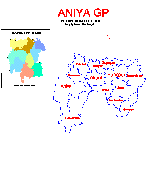
are: Akuni, Aniya, Bandpur, Banipur, Bara Choughara, Dudhkanra, Ganeshpur, Goplapur, Jiara, Kalyanbati, Mukundapur, Sadpur
Sadpur is a census town in the Habra I CD block in the Barasat Sadar subdivision in the North 24 Parganas district in the Indian state of West Bengal.
Geography
Location
Sadpur is located at .
Sadpur, Maslandapur, Nokpul and Betpuli for ...
and Shyamsundarpur.

Demographics
As per2011 Census of India
The 2011 Census of India or the 15th Indian Census was conducted in two phases, house listing and population enumeration. The House listing phase began on 1 April 2010 and involved the collection of information about all buildings. Information ...
Aniya had a total population of 3,281 of which 1,588 (48%) were males and 1693 (52%) were females. Population below 6 years was 322. The total number of literates in Aniya was 2,477 (83.71% of the population over 6 years).
Healthcare
Akuni Ichhapasar Rural Hospital at Aniya functions with 30 beds.Transport
Bargachia railway station andBaruipara railway station
Baruipara railway station is a railway station in Baruipara, a small town on the Howrah–Bardhaman chord line and is located in Hooghly district in the Indian state of West Bengal. The station is from Howrah on the Howrah–Bardhaman chord lin ...
are the nearest railway stations.
References
Villages in Chanditala I CD Block {{Hooghly-geo-stub