Alice Shoal on:
[Wikipedia]
[Google]
[Amazon]

 Alice Shoal (
Joint Regime Treaty between Colombia and Jamaica
/ref>

 Alice Shoal (
Spanish
Spanish might refer to:
* Items from or related to Spain:
**Spaniards are a nation and ethnic group indigenous to Spain
**Spanish language, spoken in Spain and many Latin American countries
**Spanish cuisine
Other places
* Spanish, Ontario, Can ...
: ''Banco Alicia'' or ''Bajo Alicia'') is a wholly submerged reef
A reef is a ridge or shoal of rock, coral or similar relatively stable material, lying beneath the surface of a natural body of water. Many reefs result from natural, abiotic processes— deposition of sand, wave erosion planing down rock o ...
, located in the western Caribbean Sea
The Caribbean Sea ( es, Mar Caribe; french: Mer des Caraïbes; ht, Lanmè Karayib; jam, Kiaribiyan Sii; nl, Caraïbische Zee; pap, Laman Karibe) is a sea of the Atlantic Ocean in the tropics of the Western Hemisphere. It is bounded by Mexico ...
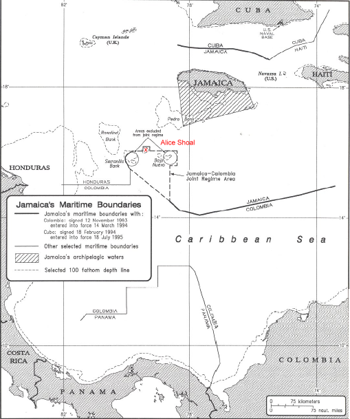
, about southwest of Jamaica
Jamaica (; ) is an island country situated in the Caribbean Sea. Spanning in area, it is the third-largest island of the Greater Antilles and the Caribbean (after Cuba and Hispaniola). Jamaica lies about south of Cuba, and west of His ...
. The mainland of Colombia lies away to the southeast.
Alice Shoal is situated 31 km northeast of East Cay of Serranilla Bank
Serranilla Bank ( es, Isla Serranilla, Banco Serranilla and ''Placer de la Serranilla'') is a partially submerged reef, with small uninhabited islets, in the western Caribbean Sea. It is situated about northeast of Punta Gorda, Nicaragua, and ...
, and 48 km west of Bajo Nuevo Bank
Bajo Nuevo Bank, also known as the Petrel Islands ( es, Bajo Nuevo, Islas Petrel), is a small, uninhabited reef with some small grass-covered islets, located in the western Caribbean Sea at , with a lighthouse on Low Cay at . The closest neighb ...
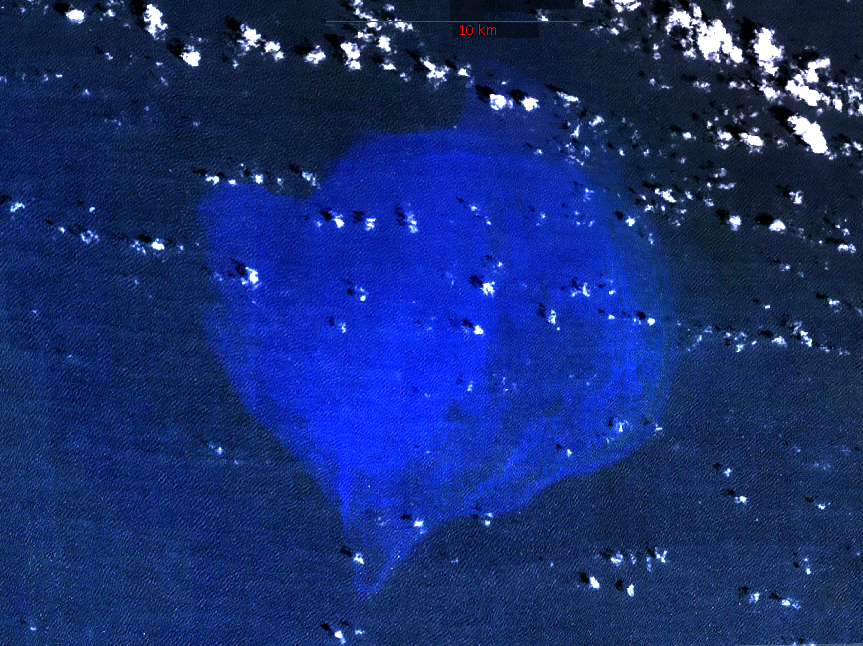
. The bank is about 16 km in diameter as defined by the 200 m isobath
Bathymetry (; ) is the study of underwater depth of ocean floors (''seabed topography''), lake floors, or river floors. In other words, bathymetry is the underwater equivalent to hypsometry or topography. The first recorded evidence of water de ...
, which corresponds to an area of more than 200 km2. There are no islets, cay
A cay ( ), also spelled caye or key, is a small, low-elevation, sandy island on the surface of a coral reef. Cays occur in tropical environments throughout the Pacific, Atlantic, and Indian Oceans, including in the Caribbean and on the Great ...
s or above-water rocks. The bank has a minimum depth of , with coral
Corals are marine invertebrates within the class Anthozoa of the phylum Cnidaria. They typically form compact colonies of many identical individual polyps. Coral species include the important reef builders that inhabit tropical oceans and ...
bottom, at its eastern edge. Depths over the greater part of the bank are less than . The bottom is fine white sand. Rip current
A rip current, often simply called a rip (or misleadingly a ''rip tide''), is a specific kind of water current that can occur near beaches with breaking waves. A rip is a strong, localized, and narrow current of water which moves directly away ...
s mark the edges of the bank.
The reef falls within the ''Joint Regime Area'' of Colombia and Jamaica, a maritime delimitation zone which allows for co-operative control and exploitation of resources between the two states./ref>
References
External links
* — satellite images. Geography of Colombia Undersea banks of the Caribbean Sea Geography of the Archipelago of San Andrés, Providencia and Santa Catalina {{Colombia-geo-stub