|
Windward And Leeward
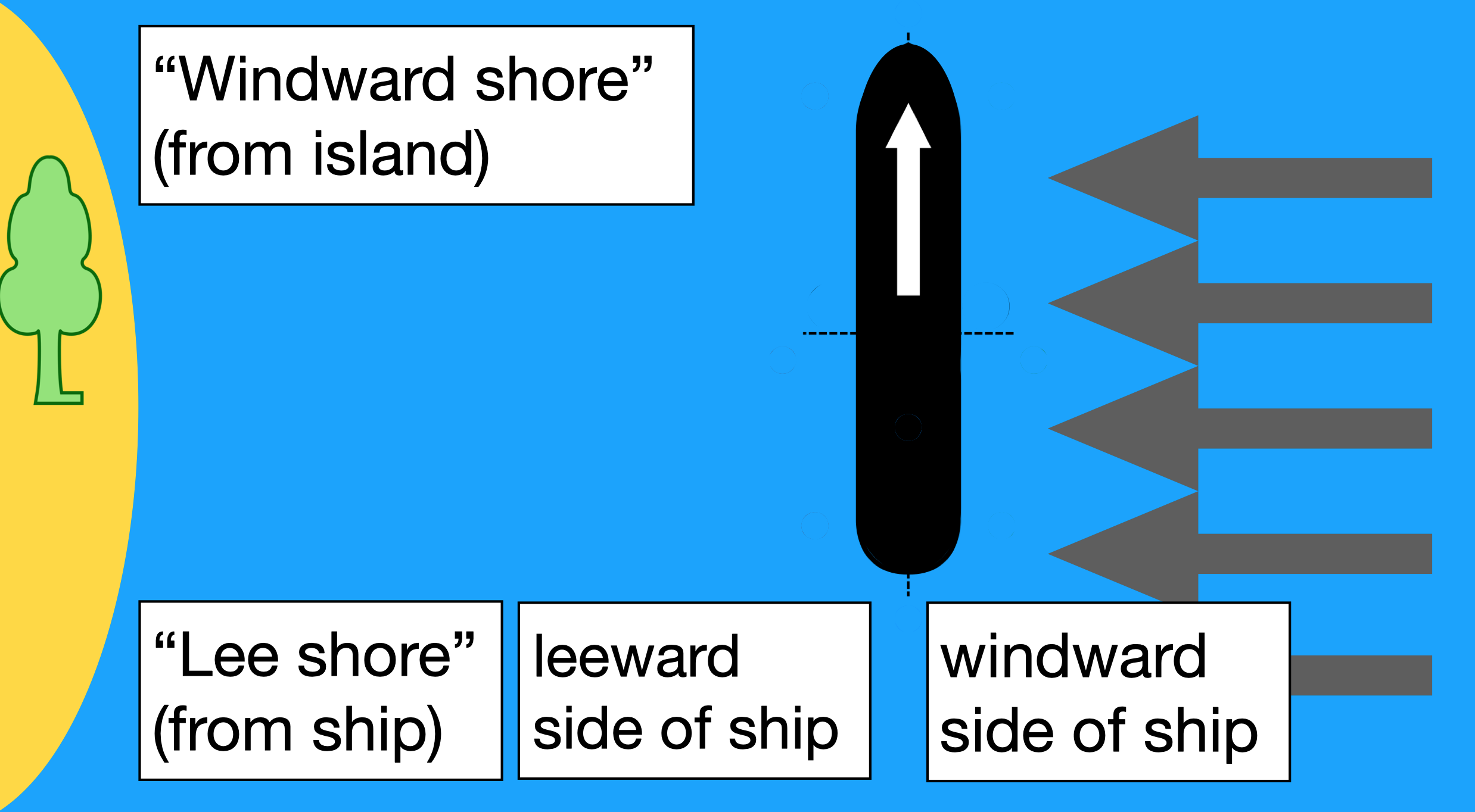
Windward () and leeward () are terms used to describe the direction of the wind. Windward is ''upwind'' from the point of reference, i.e. towards the direction from which the wind is coming; leeward is ''downwind'' from the point of reference, i.e. along the direction towards which the wind is going. The side of a ship that is towards the leeward is its "lee side". If the vessel is heeling under the pressure of crosswind, the lee side will be the "lower side". During the Age of Sail, the term ''weather'' was used as a synonym for ''windward'' in some contexts, as in the '' weather gage''. Because it captures rain, the windward side of a mountain tends to be wet compared to the leeward it blocks. Origin The term "lee" comes from the middle-low German word // meaning "where the sea is not exposed to the wind" or "mild". The terms Luv and Lee (engl. Windward and Leeward) have been in use since the 17th century. Usage Windward and leeward directions (and the points ... [...More Info...] [...Related Items...] OR: [Wikipedia] [Google] [Baidu] |
Archipelago
An archipelago ( ), sometimes called an island group or island chain, is a chain, cluster, or collection of islands, or sometimes a sea containing a small number of scattered islands. Examples of archipelagos include: the Indonesian Archipelago, the Aleutian Islands, the Lakshadweep Islands, the Galápagos Islands, the Japanese archipelago, the Philippine Archipelago, the Maldives, the Balearic Islands, the Åland Islands, The Bahamas, the Aegean Islands, the Hawaiian Islands, the Canary Islands, Malta, the Azores, the Canadian Arctic Archipelago, the British Isles, the islands of the Archipelago Sea, and Shetland. Archipelagos are sometimes defined by political boundaries. For example, while they are geopolitically divided, the San Juan Islands and Gulf Islands geologically form part of a larger Gulf Archipelago. Etymology The word ''archipelago'' is derived from the Ancient Greek ἄρχι-(''arkhi-'', "chief") and πέλαγος (''pélagos'', "sea") thr ... [...More Info...] [...Related Items...] OR: [Wikipedia] [Google] [Baidu] |
Leeward Islands
french: Îles-Sous-le-Vent , image_name = , image_caption = ''Political'' Leeward Islands. Clockwise: Antigua and Barbuda, Guadeloupe, Saint kitts and Nevis. , image_alt = , locator_map = , location = Caribbean Sea North Atlantic Ocean , coordinates = , area_km2 = , total_islands = 30+ , major_islands = Antigua and BarbudaGuadeloupeMontserrat Saint Kitts and NevisSaint Martin Virgin Islands , highest_mount = La Grande Soufrière, Guadeloupe , elevation_m = 1,467 , country = Antigua and Barbuda , country_largest_city = Saint John's, Antigua, St. John's , country1 = Guadeloupe , country1_largest_city = Les Abymes , country2 = Saint Kitts and Nevis , country2_largest_city = Basseterre , country3 = Sint Maarten , country3_largest_city = Philipsburg, Sint Maarten, Philipsburg , density_km2 = , population = +700,000 , ethnic_groups = The Leeward Islands () are a group of islands situated where the northeastern Caribbean Sea meets the western Atlantic Ocean. Starting with th ... [...More Info...] [...Related Items...] OR: [Wikipedia] [Google] [Baidu] |
Windward Islands
french: Îles du Vent , image_name = , image_caption = ''Political'' Windward Islands. Clockwise: Dominica, Martinique, Saint Lucia, Saint Vincent and the Grenadines, and Grenada. , image_alt = , locator_map = , location = Caribbean Sea North Atlantic Ocean , coordinates = , area_km2 = 3232.5 , total_islands = 90+ , major_islands = Carriacou Dominica GrenadaMartinique Petite MartiniqueSaint Lucia Saint Vincent , highest_mount = Morne Diablotins, Dominica , elevation_m = 1,447 , country = Dominica , country_largest_city = Roseau , country1 = Grenada , country1_largest_city = St. George's , country2 = Martinique , country2_largest_city = Fort-de-France , country3 = Saint Lucia , country3_largest_city = Castries , country4 = Saint Vincent and the Grenadines , country4_largest_city = Kingstown , density_km2 = 227 , population = 854,000 , ethnic_groups = The Windward Islands are the southern, generally larger islands of the Lesser Antilles. Part of the West Indies, ... [...More Info...] [...Related Items...] OR: [Wikipedia] [Google] [Baidu] |
Northwestern Hawaiian Islands
The Northwestern Hawaiian Islands or Leeward Hawaiian Islands are a series of islands and atolls in the Hawaiian island chain located northwest (in some cases, far to the northwest) of the islands of Kauai and Niihau. Politically, they are all part of Honolulu County in the U.S. state of Hawaii, except Midway Atoll, which is a territory distinct from the State of Hawaii, and grouped as one of the United States Minor Outlying Islands. The United States Census Bureau defines this area, except Midway, as Census Tract 114.98 of Honolulu County. Its total land area is . All the islands except Nihoa are north of the Tropic of Cancer, making them the only islands in Hawaii that lie outside the tropics. The Northwestern or Leeward Hawaiian Islands include: *Nihoa (Moku Manu) at * Necker (Mokumanamana) at *French Frigate Shoals (Kānemilohai) at *Gardner Pinnacles (Pūhāhonu) at * Maro Reef (Nalukākala) at * Laysan (Kauō) at * Lisianski (Papaāpoho) at * Pearl and Hermes Ato ... [...More Info...] [...Related Items...] OR: [Wikipedia] [Google] [Baidu] |
List Of Nautical Terms
This glossary of nautical terms is an alphabetical listing of terms and expressions connected with ships, shipping, seamanship and navigation on water (mostly though not necessarily on the sea). Some remain current, while many date from the 17th to 19th centuries. The word nautical derives from the Latin ''nauticus'', from Greek ''nautikos'', from ''nautēs'': "sailor", from ''naus'': "ship". Further information on nautical terminology may also be found at Nautical metaphors in English, and additional military terms are listed in the Multiservice tactical brevity code article. Terms used in other fields associated with bodies of water can be found at Glossary of fishery terms, Glossary of underwater diving terminology, Glossary of rowing terms, and Glossary of meteorology. This glossary is split into two articles: * terms starting with the letters A to L are at Glossary of nautical terms (A-L) * terms starting with the letters M to Z are at Glossary of nautical terms (M-Z). __ ... [...More Info...] [...Related Items...] OR: [Wikipedia] [Google] [Baidu] |
Lee Shore
A lee shore, sometimes also called a leeward ( shore, or more commonly ), is a nautical term to describe a stretch of shoreline that is to the lee side of a vessel—meaning the wind is blowing towards land. Its opposite, the shore on the windward side of the vessel, is called the weather or windward shore ( or, more commonly, ). Due to the dangers of being driven aground on a lee shore it is essential seamanship to treat one with caution. Use of the terms "windward", "leeward", and "lee" Usage of the terms to describe shores in relation to an arbitrary point of view, including on land, can lead to ambiguity. The windward shore of an island is a lee shore from the perspective of a vessel travelling offshore. Although the terms are often confused, "the lee shore" is different from "a leeward shore" based on the reference point from which the shore is viewed. Notice the different articles "the" and "a" — "the" windward or leeward shore versus "a" lee shore. The shore that is ... [...More Info...] [...Related Items...] OR: [Wikipedia] [Google] [Baidu] |
Foehn Wind
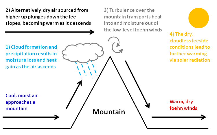
A Foehn or Föhn (, , ), is a type of dry, relatively warm, downslope wind that occurs in the lee (downwind side) of a mountain range. It is a rain shadow wind that results from the subsequent adiabatic warming of air that has dropped most of its moisture on windward slopes (see orographic lift). As a consequence of the different adiabatic lapse rates of moist and dry air, the air on the leeward slopes becomes warmer than equivalent elevations on the windward slopes. Foehn winds can raise temperatures by as much as 14 °C (25 °F) in just a matter of hours. Switzerland, southern Germany and Austria have a warmer climate due to the Foehn, as moist winds off the Mediterranean Sea blow over the Alps. Etymology The name ''Foehn'' (german: Föhn, ) arose in the Alpine region. Originating from Latin ''(ventus) favonius'', a mild west wind of which Favonius was the Roman personification and probably transmitted by rm, favuogn or just ''fuogn'', the term was adopted a ... [...More Info...] [...Related Items...] OR: [Wikipedia] [Google] [Baidu] |
Source (river Or Stream)
The headwaters of a river or stream is the farthest place in that river or stream from its estuary or downstream confluence with another river, as measured along the course of the river. It is also known as a river's source. Definition The United States Geological Survey (USGS) states that a river's "length may be considered to be the distance from the mouth to the most distant headwater source (irrespective of stream name), or from the mouth to the headwaters of the stream commonly known as the source stream". As an example of the second definition above, the USGS at times considers the Missouri River as a tributary of the Mississippi River. But it also follows the first definition above (along with virtually all other geographic authorities and publications) in using the combined Missouri—lower Mississippi length figure in lists of lengths of rivers around the world. Most rivers have numerous tributaries and change names often; it is customary to regard the longest ... [...More Info...] [...Related Items...] OR: [Wikipedia] [Google] [Baidu] |
Cape Verde Islands
, national_anthem = () , official_languages = Portuguese , national_languages = Cape Verdean Creole , capital = Praia , coordinates = , largest_city = capital , demonym = Cape Verdean or Cabo Verdean , ethnic_groups_year = 2017 , government_type = Unitary semi-presidential republic , leader_title1 = President , leader_name1 = José Maria Neves , leader_title2 = Prime Minister , leader_name2 = Ulisses Correia e Silva , legislature = National Assembly , area_rank = 166th , area_km2 = 4033 , area_sq_mi = 1,557 , percent_water = negligible , population_census = 561,901 , population_census_rank = 172nd , population_census_year = 2021 , population_density_km2 = 123.7 , population_density_sq_mi = 325.0 , population_density_rank = 89th , GDP_PPP ... [...More Info...] [...Related Items...] OR: [Wikipedia] [Google] [Baidu] |
Sotavento Islands
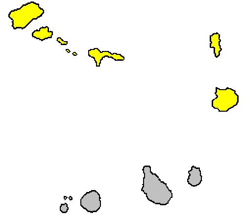
The Sotavento Islands ( Portuguese: ''Ilhas de Sotavento'', literally, the ''Leeward Islands'') is the southern island group of the Cape Verde archipelago.Valor simbólico do centro histórico da Praia Lourenço Conceição Gomes, Universidade Portucalense, 2008, p. 58-59 There are four main islands. The western three islands, Brava, Fogo and , are rocky and ... [...More Info...] [...Related Items...] OR: [Wikipedia] [Google] [Baidu] |
Barlavento Islands
The Barlavento Islands ( Portuguese: ''Ilhas de Barlavento'', literally, the ''Windward Islands'') is the northern group of the Cape Verde archipelago.Valor simbólico do centro histórico da Praia Lourenço Conceição Gomes, Universidade Portucalense, 2008, p. 58-59 It presents as two sub-groups: *in the west: Santo Antão, São Vicente, São Nicolau, Santa Luzia and i ... [...More Info...] [...Related Items...] OR: [Wikipedia] [Google] [Baidu] |


.png)


