|
Tornado Debris Signature
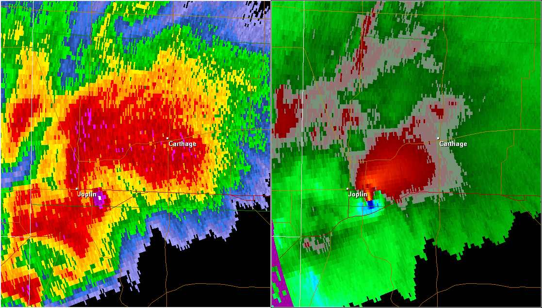
A tornadic debris signature (TDS), often colloquially referred to as a debris ball, is an area of high reflectivity on weather radar caused by debris lofting into the air, usually associated with a tornado. A TDS may also be indicated by dual-polarization Pulse-Doppler radar, radar products, designated as a polarimetric tornado debris signature (PTDS). Polarimetric radar can discern meteorological and nonmeteorological hydrometeors and the co-location of a PTDS with the enhanced reflectivity of a debris ball are used by meteorologists as confirmation that a tornado is occurring. Background Debris balls can be a result of Human impact on the environment, anthropogenic or biomass debris and are more likely to occur if a tornado crosses a "target-rich" environment such as a forest or populated area. A TDS is most likely to be observed when a tornado is closer to a radar site and the farther away from the radar that a TDS is observed the more likely that the tornado is stronger. As a r ... [...More Info...] [...Related Items...] OR: [Wikipedia] [Google] [Baidu] |
Radar Image Of The 2011 Joplin Tornado May 22, 2011 2248Z
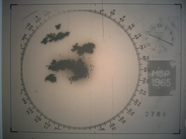
Radar is a detection system that uses radio waves to determine the distance (''ranging''), angle, and radial velocity of objects relative to the site. It can be used to detect aircraft, Marine radar, ships, spacecraft, guided missiles, motor vehicles, Weather radar, weather formations, and terrain-following radar, terrain. A radar system consists of a transmitter producing electromagnetic waves in the radio spectrum, radio or microwaves domain, a transmitting antenna (radio), antenna, a receiving antenna (often the same antenna is used for transmitting and receiving) and a radio receiver, receiver and Data processing system, processor to determine properties of the objects. Radio waves (pulsed or continuous) from the transmitter reflect off the objects and return to the receiver, giving information about the objects' locations and speeds. Radar was developed secretly for military use by several countries in the period before and during World War II. A key development was the ca ... [...More Info...] [...Related Items...] OR: [Wikipedia] [Google] [Baidu] |
Enhanced Fujita Scale
The Enhanced Fujita scale (abbreviated as EF-Scale) rates tornado intensity based on the severity of the damage they cause. It is used in some countries, including the United States, Canada, China, and Mongolia. The Enhanced Fujita scale replaced the decommissioned Fujita scale that was introduced in 1971 by Ted Fujita. Operational use began in the United States on February 1, 2007, followed by Canada on April 1, 2013. It has also been proposed for use in France. The scale has the same basic design as the original Fujita scale—six intensity categories from zero to five, representing increasing degrees of damage. It was revised to reflect better examinations of tornado damage surveys, in order to align wind speeds more closely with associated storm damage. Better standardizing and elucidating what was previously subjective and ambiguous, it also adds more types of structures and vegetation, expands degrees of damage, and better accounts for variables such as differences in con ... [...More Info...] [...Related Items...] OR: [Wikipedia] [Google] [Baidu] |
Radar Meteorology
Weather radar, also called weather surveillance radar (WSR) and Doppler weather radar, is a type of radar used to locate precipitation, calculate its motion, and estimate its type (rain, snow, hail etc.). Modern weather radars are mostly pulse-Doppler radars, capable of detecting the motion of rain droplets in addition to the intensity of the precipitation. Both types of data can be analyzed to determine the structure of storms and their potential to cause severe weather. During World War II, radar operators discovered that weather was causing echoes on their screen, masking potential enemy targets. Techniques were developed to filter them, but scientists began to study the phenomenon. Soon after the war, surplus radars were used to detect precipitation. Since then, weather radar has evolved on its own and is now used by national weather services, research departments in universities, and in television stations' weather departments. Raw images are routinely used and specialize ... [...More Info...] [...Related Items...] OR: [Wikipedia] [Google] [Baidu] |
Warning Decision Training Branch
The Warning Decision Training Division (WDTD), known as the Warning Decision Training Branch until April 1, 2015, is one of three training organizations in the NWS Training Division which also includes the Forecast Decision Training Branch and the NWS Training Center. WDTD develops and delivers training on the integrated elements of the warning process within a National Oceanic and Atmospheric Administration (NOAA)/National Weather Service (NWS) forecast office. WDTD instructors develop and deliver a variety of in-residence, teletraining, and on-line asynchronous training content. History NEXRAD Training Unit With the nationwide implementation of the NEXRAD program, NWS management formed a training group designed to create and teach a course dedicated to the understanding and application of the WSR-88D radar. In the summer of 1989, this training group, called the Operations Training Facility (OTF) was staffed with six meteorologist instructors and a secretary (referred to as the ... [...More Info...] [...Related Items...] OR: [Wikipedia] [Google] [Baidu] |
Mesocyclone
A mesocyclone is a meso-gamma mesoscale (or storm scale) region of rotation (vortex), typically around in diameter, most often noticed on radar within thunderstorms. In the northern hemisphere it is usually located in the right rear flank (back edge with respect to direction of movement) of a supercell, or often on the eastern, or leading, flank of a high-precipitation variety of supercell. The area overlaid by a mesocyclone’s circulation may be several miles (km) wide, but substantially larger than any tornado that may develop within it, and it is within mesocyclones that intense tornadoes form. Description Mesocyclones are medium-scale vortices of rising and converging air that circulate around a vertical axis. They are most often associated with a local region of low-pressure. Their rotation is (usually) in the same direction as low pressure systems in a given hemisphere: counter-clockwise in the northern, and clockwise in the southern hemisphere, with the only occasio ... [...More Info...] [...Related Items...] OR: [Wikipedia] [Google] [Baidu] |
Convective Storm Detection
Convective storm detection is the meteorological observation, and short-term prediction, of deep moist convection (DMC). DMC describes atmospheric conditions producing single or clusters of large vertical extension clouds ranging from cumulus congestus to cumulonimbus, the latter producing thunderstorms associated with lightning and thunder. Those two types of clouds can produce severe weather at the surface and aloft. The ability to discern the presence of deep moist convection in a storm significantly improves meteorologists' capacity to predict and monitor associated phenomena such as tornadoes, large hail, strong winds, and heavy rain leading to flash flooding. It relies on direct eyewitness observations, for example from storm spotters; and on remote sensing, especially weather radar. Some in situ measurements are used for direct detection as well, notably, wind speed reports from surface observation stations. It is part of the ''integrated warning system'', consisting of p ... [...More Info...] [...Related Items...] OR: [Wikipedia] [Google] [Baidu] |
Tornado Vortex Signature
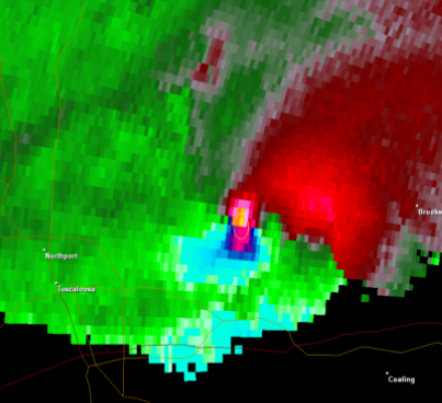
A tornadic vortex signature, abbreviated TVS, is a Pulse-Doppler radar weather radar detected rotation algorithm that indicates the likely presence of a strong mesocyclone that is in some stage of tornadogenesis. It may give meteorologists the ability to pinpoint and track the location of tornadic rotation within a larger storm, but it is not an important feature in the National Weather Service's warning operations. The tornadic vortex signature was first identified by Donald W. Burgess, Leslie R. Lemon, and Rodger A. Brown in the 1970s using experimental Doppler radar at the National Severe Storms Laboratory (NSSL) in Norman, Oklahoma. The National Weather Service (NWS) now uses an updated algorithm developed by NSSL, the ''tornado detection algorithm'' (TDA) based on data from its WSR-88D system of radars. NSSL also developed the ''mesocyclone detection algorithm'' (MDA). Display The conditions causing a TVS are often visible on the Doppler weather radar storm relative velocity ... [...More Info...] [...Related Items...] OR: [Wikipedia] [Google] [Baidu] |
Weather Radar
Weather radar, also called weather surveillance radar (WSR) and Doppler weather radar, is a type of radar used to locate precipitation, calculate its motion, and estimate its type (rain, snow, hail etc.). Modern weather radars are mostly pulse-Doppler radars, capable of detecting the motion of rain droplets in addition to the intensity of the precipitation. Both types of data can be analyzed to determine the structure of storms and their potential to cause severe weather. During World War II, radar operators discovered that weather was causing echoes on their screen, masking potential enemy targets. Techniques were developed to filter them, but scientists began to study the phenomenon. Soon after the war, surplus radars were used to detect precipitation. Since then, weather radar has evolved on its own and is now used by national weather services, research departments in universities, and in television stations' weather departments. Raw images are routinely used and speciali ... [...More Info...] [...Related Items...] OR: [Wikipedia] [Google] [Baidu] |
DBZ (meteorology)
dBZ stands for '' decibel relative to Z''. It is a logarithmic dimensionless technical unit used in radar, mostly in weather radar, to compare the equivalent reflectivity factor (Z) of a remote object (in mm6 per m3) to the return of a droplet of rain with a diameter of 1 mm (1 mm6 per m3). It is proportional to the number of drops per unit volume and the sixth power of drops' diameter and is thus used to estimate the rain or snow intensity. With other variables analyzed from the radar returns it helps to determine the type of precipitation. Both the radar reflectivity factor and its logarithmic version are commonly referred to as ''reflectivity'' when the context is clear. In short, the higher the dBZ value, the more likely it is for severe weather to occur in the form of precipitation. Values above 20 dBZ usually indicate falling precipitation. Principle The radar reflectivity factor (Z) of precipitation is dependent on the number (N0) and size (D) of reflec ... [...More Info...] [...Related Items...] OR: [Wikipedia] [Google] [Baidu] |
2011 Super Outbreak
The 2011 Super Outbreak was the largest, costliest, and one of the deadliest tornado outbreaks ever recorded, taking place in the Southern, Midwestern, and Northeastern United States from April 25–28, 2011, leaving catastrophic destruction in its wake. Over 175 tornadoes struck Alabama, Mississippi, and Tennessee, which were the most severely damaged states. Other destructive tornadoes occurred in Arkansas, Georgia, Kentucky, Louisiana, New York, and Virginia, with storms also affecting other states in the Southern and Eastern United States. In total, 360 tornadoes were confirmed by NOAA's National Weather Service (NWS) and Government of Canada's Environment Canada in 21 states from Texas to New York to southern Canada. Widespread and destructive tornadoes occurred on each day of the outbreak. April 27 was the most active day, with a record 216 tornadoes touching down that day from midnight to midnight CDT (05:00 – 05:00 UTC). Four of the tornadoes were rated EF5, which i ... [...More Info...] [...Related Items...] OR: [Wikipedia] [Google] [Baidu] |
Wind
Wind is the natural movement of air or other gases relative to a planet's surface. Winds occur on a range of scales, from thunderstorm flows lasting tens of minutes, to local breezes generated by heating of land surfaces and lasting a few hours, to global winds resulting from the difference in absorption of solar energy between the climate zones on Earth. The two main causes of large-scale atmospheric circulation are the differential heating between the equator and the poles, and the rotation of the planet (Coriolis effect). Within the tropics and subtropics, thermal low circulations over terrain and high plateaus can drive monsoon circulations. In coastal areas the sea breeze/land breeze cycle can define local winds; in areas that have variable terrain, mountain and valley breezes can prevail. Winds are commonly classified by their spatial scale, their speed and direction, the forces that cause them, the regions in which they occur, and their effect. Winds have various asp ... [...More Info...] [...Related Items...] OR: [Wikipedia] [Google] [Baidu] |
Reflectivity
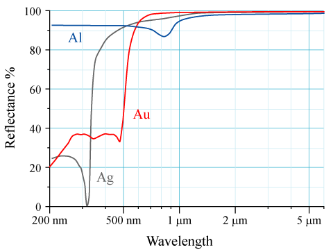
The reflectance of the surface of a material is its effectiveness in reflecting radiant energy. It is the fraction of incident electromagnetic power that is reflected at the boundary. Reflectance is a component of the response of the electronic structure of the material to the electromagnetic field of light, and is in general a function of the frequency, or wavelength, of the light, its polarization, and the angle of incidence. The dependence of reflectance on the wavelength is called a ''reflectance spectrum'' or ''spectral reflectance curve''. Mathematical definitions Hemispherical reflectance The ''hemispherical reflectance'' of a surface, denoted , is defined as R = \frac, where is the radiant flux ''reflected'' by that surface and is the radiant flux ''received'' by that surface. Spectral hemispherical reflectance The ''spectral hemispherical reflectance in frequency'' and ''spectral hemispherical reflectance in wavelength'' of a surface, denoted and respectively, are ... [...More Info...] [...Related Items...] OR: [Wikipedia] [Google] [Baidu] |


