|
Ocean Currents
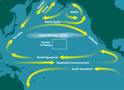
An ocean current is a continuous, directed movement of sea water generated by a number of forces acting upon the water, including wind, the Coriolis effect, breaking waves, cabbeling, and temperature and salinity differences. Depth contours, shoreline configurations, and interactions with other currents influence a current's direction and strength. Ocean currents are primarily horizontal water movements. An ocean current flows for great distances and together they create the global conveyor belt, which plays a dominant role in determining the climate of many of Earth’s regions. More specifically, ocean currents influence the temperature of the regions through which they travel. For example, warm currents traveling along more temperate coasts increase the temperature of the area by warming the sea breezes that blow over them. Perhaps the most striking example is the Gulf Stream, which makes northwest Europe much more temperate for its high latitude compared to other areas ... [...More Info...] [...Related Items...] OR: [Wikipedia] [Google] [Baidu] |
Temperate
In geography, the temperate climates of Earth occur in the middle latitudes (23.5° to 66.5° N/S of Equator), which span between the tropics and the polar regions of Earth. These zones generally have wider temperature ranges throughout the year and more distinct seasonal changes compared to tropical climates, where such variations are often small and usually only have precipitation changes. In temperate climates, not only do latitudinal positions influence temperature changes, but sea currents, prevailing wind direction, continentality (how large a landmass is) and altitude also shape temperate climates. The Köppen climate classification defines a climate as "temperate" C, when the mean temperature is above but below in the coldest month to account for the persistency of frost. However, other climate classifications set the minimum at . Zones and climates The north temperate zone extends from the Tropic of Cancer (approximately 23.5° north latitude) to the Arctic ... [...More Info...] [...Related Items...] OR: [Wikipedia] [Google] [Baidu] |
Upwelling
Upwelling is an oceanographic phenomenon that involves wind-driven motion of dense, cooler, and usually nutrient-rich water from deep water towards the ocean surface. It replaces the warmer and usually nutrient-depleted surface water. The nutrient-rich upwelled water stimulates the growth and reproduction of primary producers such as phytoplankton. The biomass of phytoplankton and the presence of cool water in those regions allow upwelling zones to be identified by cool sea surface temperatures (SST) and high concentrations of chlorophyll-a. The increased availability of nutrients in upwelling regions results in high levels of primary production and thus fishery production. Approximately 25% of the total global marine fish catches come from five upwellings, which occupy only 5% of the total ocean area.Jennings, S., Kaiser, M.J., Reynolds, J.D. (2001) "Marine Fisheries Ecology." Oxford: Blackwell Science Ltd. Upwellings that are driven by coastal currents or diverging ope ... [...More Info...] [...Related Items...] OR: [Wikipedia] [Google] [Baidu] |
Thermohaline Circulation
Thermohaline circulation (THC) is a part of the large-scale ocean circulation that is driven by global density gradients created by surface heat and freshwater fluxes. The adjective ''thermohaline'' derives from '' thermo-'' referring to temperature and ' referring to salt content, factors which together determine the density of sea water. Wind-driven surface currents (such as the Gulf Stream) travel polewards from the equatorial Atlantic Ocean, cooling en route, and eventually sinking at high latitudes (forming North Atlantic Deep Water). This dense water then flows into the ocean basins. While the bulk of it upwells in the Southern Ocean, the oldest waters (with a transit time of about 1000 years) upwell in the North Pacific. Extensive mixing therefore takes place between the ocean basins, reducing differences between them and making the Earth's oceans a global system. The water in these circuits transport both energy (in the form of heat) and mass (dissolved solids an ... [...More Info...] [...Related Items...] OR: [Wikipedia] [Google] [Baidu] |
Density
Density (volumetric mass density or specific mass) is the substance's mass per unit of volume. The symbol most often used for density is ''ρ'' (the lower case Greek letter rho), although the Latin letter ''D'' can also be used. Mathematically, density is defined as mass divided by volume: : \rho = \frac where ''ρ'' is the density, ''m'' is the mass, and ''V'' is the volume. In some cases (for instance, in the United States oil and gas industry), density is loosely defined as its weight per unit volume, although this is scientifically inaccurate – this quantity is more specifically called specific weight. For a pure substance the density has the same numerical value as its mass concentration. Different materials usually have different densities, and density may be relevant to buoyancy, purity and packaging. Osmium and iridium are the densest known elements at standard conditions for temperature and pressure. To simplify comparisons of density across different syst ... [...More Info...] [...Related Items...] OR: [Wikipedia] [Google] [Baidu] |
Western Boundary Current
Boundary currents are ocean currents with dynamics determined by the presence of a coastline, and fall into two distinct categories: western boundary currents and eastern boundary currents. Eastern boundary currents Eastern boundary currents are relatively shallow, broad and slow-flowing. They are found on the eastern side of oceanic basins (adjacent to the western coasts of continents). Subtropical eastern boundary currents flow equatorward, transporting cold water from higher latitudes to lower latitudes; examples include the Benguela Current, the Canary Current, the Humboldt (Peru) Current, and the California Current. Coastal upwelling often brings nutrient-rich water into eastern boundary current regions, making them productive areas of the ocean. Western boundary currents Western boundary currents may themselves be divided into sub-tropical or low-latitude western boundary currents. Sub-tropical western boundary currents are warm, deep, narrow, and fast-flowing current ... [...More Info...] [...Related Items...] OR: [Wikipedia] [Google] [Baidu] |
Season
A season is a division of the year based on changes in weather, ecology, and the number of daylight hours in a given region. On Earth, seasons are the result of the axial parallelism of Earth's tilted orbit around the Sun. In temperate and polar regions, the seasons are marked by changes in the intensity of sunlight that reaches the Earth's surface, variations of which may cause animals to undergo hibernation or to migrate, and plants to be dormant. Various cultures define the number and nature of seasons based on regional variations, and as such there are a number of both modern and historical cultures whose number of seasons varies. The Northern Hemisphere experiences most direct sunlight during May, June, and July, as the hemisphere faces the Sun. The same is true of the Southern Hemisphere in November, December, and January. It is Earth's axial tilt that causes the Sun to be higher in the sky during the summer months, which increases the solar flux. However, due to ... [...More Info...] [...Related Items...] OR: [Wikipedia] [Google] [Baidu] |
National Oceanic And Atmospheric Administration
The National Oceanic and Atmospheric Administration (abbreviated as NOAA ) is an United States scientific and regulatory agency within the United States Department of Commerce that forecasts weather, monitors oceanic and atmospheric conditions, charts the seas, conducts deep sea exploration, and manages fishing and protection of marine mammals and endangered species in the U.S. exclusive economic zone. Purpose and function NOAA's specific roles include: * ''Supplying Environmental Information Products''. NOAA supplies to its customers and partners information pertaining to the state of the oceans and the atmosphere, such as weather warnings and forecasts via the National Weather Service. NOAA's information services extend as well to climate, ecosystems, and commerce. * ''Providing Environmental Stewardship Services''. NOAA is a steward of U.S. coastal and marine environments. In coordination with federal, state, local, tribal and international authorities, NOAA manages the ... [...More Info...] [...Related Items...] OR: [Wikipedia] [Google] [Baidu] |
Northern Hemisphere
The Northern Hemisphere is the half of Earth that is north of the Equator. For other planets in the Solar System, north is defined as being in the same celestial hemisphere relative to the invariable plane of the solar system as Earth's North Pole. Owing to Earth's axial tilt of 23.439281°, winter Winter is the coldest season of the year in Polar regions of Earth, polar and temperate climates. It occurs after autumn and before spring (season), spring. The tilt of Axial tilt#Earth, Earth's axis causes seasons; winter occurs when a Hemi ... in the Northern Hemisphere lasts from the December solstice (typically December 21 UTC) to the March equinox (typically March 20 UTC), while summer lasts from the June solstice through to the September equinox (typically on 23 September UTC). The dates vary each year due to the difference between the calendar year and the Year#Astronomical years, astronomical year. Within the Northern Hemisphere, oceanic currents can change the ... [...More Info...] [...Related Items...] OR: [Wikipedia] [Google] [Baidu] |
Ekman Spiral
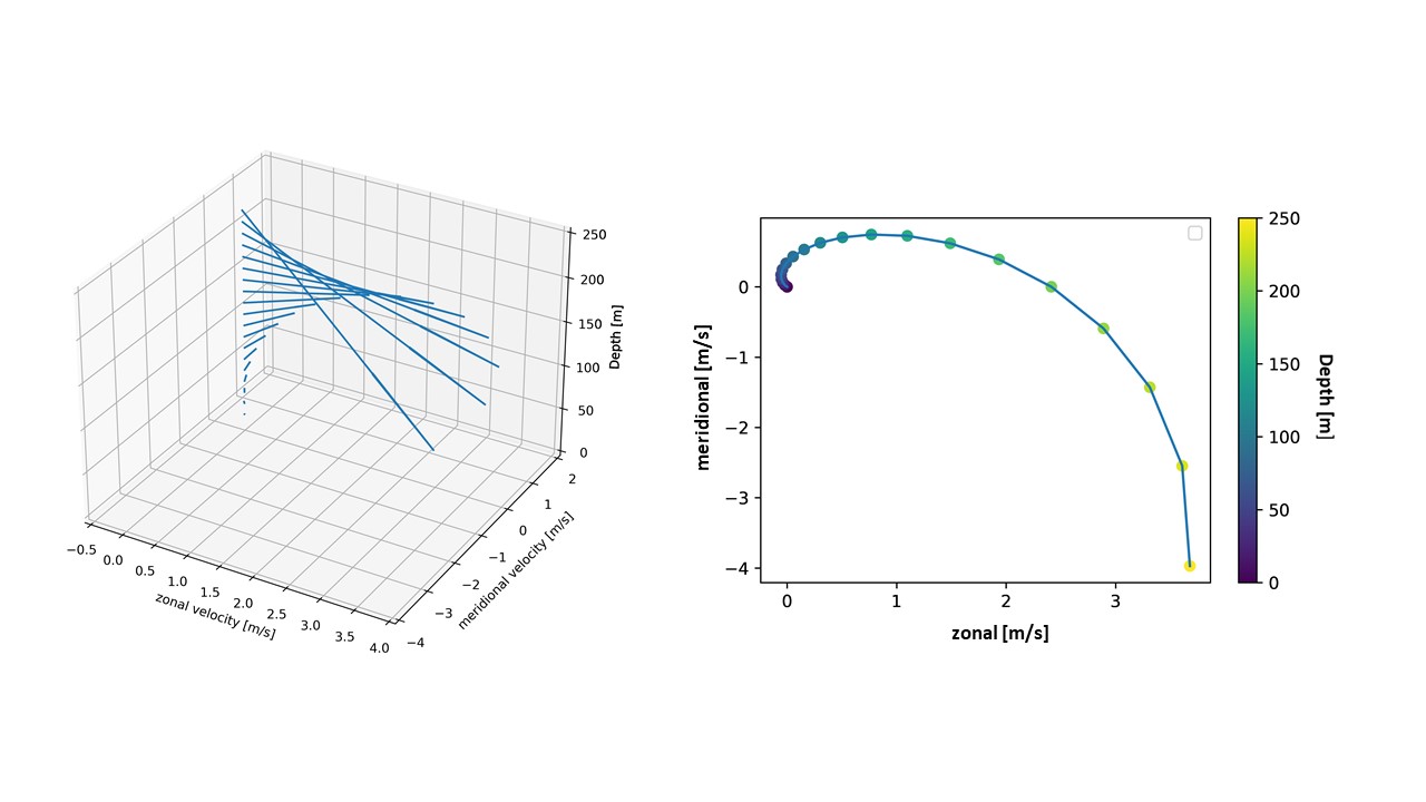
The oceanic, wind driven Ekman spiral is the result of a force balance created by a shear stress force, Coriolis force and the water drag. This force balance gives a resulting current of the water different from the winds. In the ocean, there are two places where the Ekman spiral can be observed. At the surface of the ocean, the shear stress force corresponds with the wind stress force. At the bottom of the ocean, the shear stress force is created by friction with the ocean floor. This phenomenon was first observed at the surface by the Norwegian oceanographer Fridtjof Nansen during his Fram expedition. He noticed that icebergs did not drift in the same direction as the wind. His student, the Swedish oceanographer Vagn Walfrid Ekman, was the first person to physically explain this process. Bottom Ekman Spiral In order to derive the properties of an Ekman spiral a look is taken at a uniform, horizontal geostrophic interior flow in a homogeneous fluid. This flow will by denot ... [...More Info...] [...Related Items...] OR: [Wikipedia] [Google] [Baidu] |
Sverdrup
In oceanography, the sverdrup (symbol: Sv) is a non- SI metric unit of volumetric flow rate, with equal to . It is equivalent to the SI derived unit cubic hectometer per second (symbol: hm3/s or hm3⋅s−1): 1 Sv is equal to 1 hm3/s. It is used almost exclusively in oceanography to measure the volumetric rate of transport of ocean currents. It is named after Harald Sverdrup. One sverdrup is about five times what is carried by the world’s largest river, the Amazon. In the context of ocean currents, a volume of one million cubic meters may be imagined as a "slice" of ocean with dimensions × × (width × length × thickness). At this scale, these units can be more easily compared in terms of width of the current (several km), depth (hundreds of meters), and current speed (as meters per second). Thus, a hypothetical current wide, 500 m (0.5 km) deep, and moving at 2 m/s would be transporting of water. The sverdrup is distinct from the SI sievert unit ... [...More Info...] [...Related Items...] OR: [Wikipedia] [Google] [Baidu] |


