|
Municipalities Of Chiapas
Chiapas is a state in Southwest Mexico. According to the 2020 Mexican Census, it has the eighth largest population of all states with inhabitants and the 10th largest by land area spanning . Chiapas is officially divided into 124 municipalities, although the establishment of municipal authorities in Belisario Domínguez was suspended in 2015 pending the resolution of a territorial dispute between Chiapas and the neighbouring state of Oaxaca. In 2021, the Mexican Supreme Court resolved this dispute in Oaxaca's favour, and annulled the 2011 decree that had created Belisario Domínguez. Municipalities in Chiapas are administratively autonomous of the state according to the 115th article of the 1917 Constitution of Mexico. Every three years, citizens elect a municipal president (Spanish: ''presidente municipal'') by a plurality voting system who heads a concurrently elected municipal council (''ayuntamiento'') responsible for providing all the public services for their constit ... [...More Info...] [...Related Items...] OR: [Wikipedia] [Google] [Baidu] |
Chiapas In Mexico (location Map Scheme)
Chiapas (; Tzotzil language, Tzotzil and Tzeltal language, Tzeltal: ''Chyapas'' ), officially the Free and Sovereign State of Chiapas ( es, Estado Libre y Soberano de Chiapas), is one of the states that make up the Political divisions of Mexico, 32 federal entities of Mexico. It comprises Municipalities of Chiapas, 124 municipalities and its capital and largest city is Tuxtla Gutiérrez. Other important population centers in Chiapas include Ocosingo, Tapachula, San Cristóbal de las Casas, Comitán, and Arriaga, Chiapas, Arriaga. Chiapas is the southernmost state in Mexico, and it borders the states of Oaxaca to the west, Veracruz to the northwest, and Tabasco to the north, and the Petén Department, Petén, Quiché Department, Quiché, Huehuetenango Department, Huehuetenango, and San Marcos Department, San Marcos departments of Guatemala to the east and southeast. Chiapas has a significant coastline on the Pacific Ocean to the southwest. In general, Chiapas has a humid, tropical ... [...More Info...] [...Related Items...] OR: [Wikipedia] [Google] [Baidu] |
Ocosingo
Ocosingo is a city and its surrounding municipality (''municipio'') of the same name in the Mexican state of Chiapas. Overview The northeastern boundary of the municipality is the Usumacinta River, along a portion where the river forms the international border with Guatemala. As of 2010, the municipality had a total population of 198,877, up from 170,280 as of 2005. As of 2010, the city of Ocosingo had a population of 41,878, up from 35,065 as of 2005. Other than the city of Ocosingo, the municipality had 1,387 localities, the largest of which (with 2010 populations in parentheses) were: Nueva Palestina (10,588), Frontera Corozal (5,184), Tenango (4,436), Abasolo (2,884), classified as urban, and Damasco (2,380), Taniperla (2,106), San Quintín (1,732), Cristóbal Colón (1,623), Santo Domingo (1,584), Cintalapa (1,571), Perla de Acapulco (1,527), Santa Elena (1,508), El Censo (1,500), El Sibal (1,472), Nuevo Francisco León (1,420), El Zapotal (1,385), Las Taza ... [...More Info...] [...Related Items...] OR: [Wikipedia] [Google] [Baidu] |
Aldama, Chiapas
Aldama Municipality is one of the 122 municipalities of Chiapas, in southern Mexico. The municipal seat is Aldama, Chiapas. Demographics As of 2010, the municipality had a total population of 5,072, up from 3,635 as of 2005. As of 2010, the town of Aldama had a population of 1,273. Localities Other than the town of Aldama, the municipality had 20 localities, none of which had a population over 1,000. References Municipalities of Chiapas {{Chiapas-geo-stub ... [...More Info...] [...Related Items...] OR: [Wikipedia] [Google] [Baidu] |
Aldama Municipality, Chiapas
Aldama Municipality is one of the 122 municipalities of Chiapas, in southern Mexico. The municipal seat is Aldama, Chiapas. Demographics As of 2010, the municipality had a total population of 5,072, up from 3,635 as of 2005. As of 2010, the town of Aldama had a population of 1,273. Localities Other than the town of Aldama, the municipality had 20 localities, none of which had a population over 1,000. References Municipalities of Chiapas {{Chiapas-geo-stub ... [...More Info...] [...Related Items...] OR: [Wikipedia] [Google] [Baidu] |
Acapetahua
Acapetahua is a town and one of the 122 Municipalities of Chiapas, in southern Mexico. As of 2010, the municipality had a total population of 27,580, up from 14,189 in 2005. As of 2010, the town of Acapetahua had a population of 6,194. Other than the town of Acapetahua, the municipality had 272 localities, the largest of which (with 2010 populations in parentheses) were: Soconusco (2,502), classified as urban, and Consuelo Ulapa (1,937), El Arenal (1,157), and Jiquilpan (Estación Bonanza) (1,119), classified as rural. History The precise date that the town was founded is unknown. However, it existed well before the Spanish conquered the continent. In 1524, Pedro de Alvarado conquered the region known as Soconusco, In 1526 the region formed part of the Spanish colonization and in 1529 was annexed to México. In 1774 it was formed as part of the town of Escuintla Escuintla () is an industrial city in Guatemala, its land extension is 4384 km², and it is nationally known fo ... [...More Info...] [...Related Items...] OR: [Wikipedia] [Google] [Baidu] |
Acala, Chiapas
Acala is the municipal seat of Acala Municipality, in Chiapas, southern Mexico. As of 2010, the city of Acala had a population of 13,889, up from 12,686 as of 2005. References {{Reflist Populated places in Chiapas ... [...More Info...] [...Related Items...] OR: [Wikipedia] [Google] [Baidu] |
Acala Municipality
Acala is a municipality in the Mexican state of Chiapas, in southern Mexico. The municipal seat is Acala or Achala ( sa, अचल, "The Immovable", ), also known as (, "Immovable Lord") or (, "Noble Immovable Lord"), is a wrathful deity and ''dharmapala'' (protector of the Dharma) prominent in Vajrayana Buddhism and East Asian Buddhism., Jp. re .... As of 2010, the municipality had a total population of 28,947, up from 24,800 as of 2005. Geography As of 2010, the city of Acala had a population of 13,889, up from 12,686 as of 2005. Other than the city of Acala, the municipality had 258 localities, the largest of which (with 2010 populations in parentheses) were: 20 de Noviembre (4,636), classified as urban, and Nuevo Vicente Guerrero (El Chichonal) (2,088) and Unión Buenavista (1,847), classified as rural. It covers an area of 295.6 km². Climate References {{Authority control Municipalities of Chiapas ... [...More Info...] [...Related Items...] OR: [Wikipedia] [Google] [Baidu] |
Acacoyagua
Acacoyagua Municipality one of the 122 municipalities of Chiapas, which in turn is one of the states of Mexico. As of 2010, the municipality had a total population of 16,814, up from 14,189 as of 2005. History The area is notable for being the place where the first organized Japanese immigrants settled in Mexico. In 1897, thirty five initial colonists led by Enomoto Takeaki arrived to work on coffee farms, making Mexico the first Latin American country to receive Japanese immigrants. Although the coffee endeavor failed, the colonists began farming vegetables and flowers. Over the following 30 years, six more "waves" of migrants followed. As most of the migrants were men, marriage with local women and conversion to Roman Catholicism was common. Nikkei have become Municipal President, the first being Juvencio Nishizama Cruz in 1954 and the latest being José Martín Nomura Hernandez in 2005. The main garden in town has Japanese influences and there is a monument commemorating the ... [...More Info...] [...Related Items...] OR: [Wikipedia] [Google] [Baidu] |
Acacoyagua Municipality
Acacoyagua Municipality one of the 122 municipalities of Chiapas, which in turn is one of the states of Mexico. As of 2010, the municipality had a total population of 16,814, up from 14,189 as of 2005. History The area is notable for being the place where the first organized Japanese immigrants settled in Mexico. In 1897, thirty five initial colonists led by Enomoto Takeaki arrived to work on coffee farms, making Mexico the first Latin American country to receive Japanese immigrants. Although the coffee endeavor failed, the colonists began farming vegetables and flowers. Over the following 30 years, six more "waves" of migrants followed. As most of the migrants were men, marriage with local women and conversion to Roman Catholicism was common. Nikkei have become Municipal President, the first being Juvencio Nishizama Cruz in 1954 and the latest being José Martín Nomura Hernandez in 2005. The main garden in town has Japanese influences and there is a monument commemorating ... [...More Info...] [...Related Items...] OR: [Wikipedia] [Google] [Baidu] |
INEGI
The National Institute of Statistics and Geography (INEGI by its name in es, Instituto Nacional de Estadística, Geografía e Informática) is an autonomous agency of the Mexican Government dedicated to coordinate the National System of Statistical and Geographical Information of the country. It was created on January 25, 1983, by presidential decree of Miguel de la Madrid. It is the institution responsible for conducting the Censo General de Población y Vivienda every ten years; as well as the economic census every five years and the agricultural, livestock and forestry census of the country. The job of gathering statistical information of the Institute includes the monthly gross domestic product, consumer trust surveys and proportion of commercial samples; employment and occupation statistics, domestic and couple violence; as well as many other jobs that are the basis of studies and projections to other governmental institutions. The Institute headquarters are in Aguasca ... [...More Info...] [...Related Items...] OR: [Wikipedia] [Google] [Baidu] |
Comitán
Comitán (; formally: Comitán de Domínguez, for Belisario Domínguez ''Enciclopedia de los Municipios de México'') is the fourth-largest city in the of . It is the seat of government of the municipality of the same name. It is located in the east-central part of Chiapas, near the border with at . The mu ... [...More Info...] [...Related Items...] OR: [Wikipedia] [Google] [Baidu] |
San Cristóbal De Las Casas
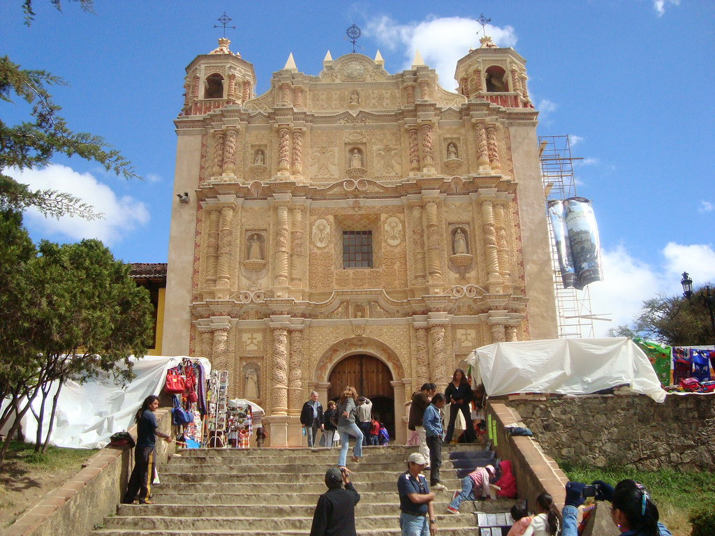
San Cristóbal de las Casas (), also known by its native Tzotzil name, Jovel (), is a town and municipality located in the Central Highlands region of the Mexican state of Chiapas. It was the capital of the state until 1892, and is still considered the cultural capital of Chiapas. The municipality is mostly made up of mountainous terrain, but the city sits in a small valley surrounded by hills. The city’s center maintains its Spanish colonial layout and much of its architecture, with red tile roofs, cobblestone streets and wrought iron balconies often with flowers. Most of the city’s economy is based on commerce, services and tourism. Tourism is based on the city’s history, culture and indigenous population, although the tourism itself has affected the city, giving it foreign elements. Major landmarks of the city include the Cathedral, the Santo Domingo church with its large open air crafts market and the Casa Na Bolom museum. The municipality has suffered severe defor ... [...More Info...] [...Related Items...] OR: [Wikipedia] [Google] [Baidu] |


