|
Loxodrome
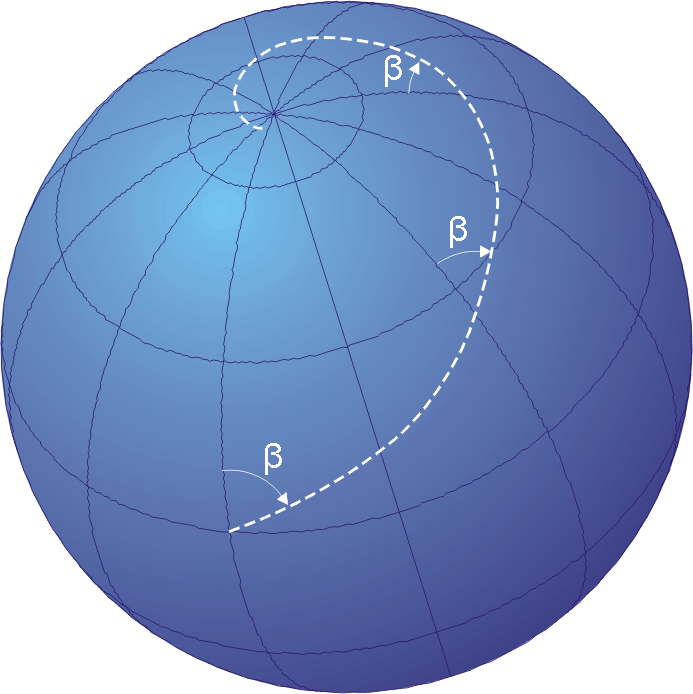
In navigation, a rhumb line, rhumb (), or loxodrome is an arc crossing all meridians of longitude at the same angle, that is, a path with constant bearing as measured relative to true north. Introduction The effect of following a rhumb line course on the surface of a globe was first discussed by the Portuguese mathematician Pedro Nunes in 1537, in his ''Treatise in Defense of the Marine Chart'', with further mathematical development by Thomas Harriot in the 1590s. A rhumb line can be contrasted with a great circle, which is the path of shortest distance between two points on the surface of a sphere. On a great circle, the bearing to the destination point does not remain constant. If one were to drive a car along a great circle one would hold the steering wheel fixed, but to follow a rhumb line one would have to turn the wheel, turning it more sharply as the poles are approached. In other words, a great circle is locally "straight" with zero geodesic curvature, whereas a ... [...More Info...] [...Related Items...] OR: [Wikipedia] [Google] [Baidu] |
Stereographic Projection
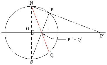
In mathematics, a stereographic projection is a perspective projection of the sphere, through a specific point on the sphere (the ''pole'' or ''center of projection''), onto a plane (the ''projection plane'') perpendicular to the diameter through the point. It is a smooth, bijective function from the entire sphere except the center of projection to the entire plane. It maps circles on the sphere to circles or lines on the plane, and is conformal, meaning that it preserves angles at which curves meet and thus locally approximately preserves shapes. It is neither isometric (distance preserving) nor equiareal (area preserving). The stereographic projection gives a way to represent a sphere by a plane. The metric induced by the inverse stereographic projection from the plane to the sphere defines a geodesic distance between points in the plane equal to the spherical distance between the spherical points they represent. A two-dimensional coordinate system on the stere ... [...More Info...] [...Related Items...] OR: [Wikipedia] [Google] [Baidu] |
Mercator Projection
The Mercator projection () is a cylindrical map projection presented by Flemish geographer and cartographer Gerardus Mercator in 1569. It became the standard map projection for navigation because it is unique in representing north as up and south as down everywhere while preserving local directions and shapes. The map is thereby conformal. As a side effect, the Mercator projection inflates the size of objects away from the equator. This inflation is very small near the equator but accelerates with increasing latitude to become infinite at the poles. As a result, landmasses such as Greenland, Antarctica and Russia appear far larger than they actually are relative to landmasses near the equator, such as Central Africa. History There is some controversy over the origins of the Mercator. German polymath Erhard Etzlaub engraved miniature "compass maps" (about 10×8 cm) of Europe and parts of Africa that spanned latitudes 0°–67° to allow adjustment of his portable pock ... [...More Info...] [...Related Items...] OR: [Wikipedia] [Google] [Baidu] |
Pedro Nunes
Pedro Nunes (; Latin: ''Petrus Nonius''; 1502 – 11 August 1578) was a Portuguese mathematician, cosmographer, and professor, from a New Christian (of Jewish origin) family. Considered one of the greatest mathematicians of his time, Nunes is best known for his contributions to the nautical sciences (navigation and cartography), which he approached, for the first time, in a mathematical way. He was the first to propose the idea of a loxodrome, and was the inventor of several measuring devices, including the nonius (from which Vernier scale was derived), named after his Latin surname. Life Little is known about Nunes' early education, life or family background, only that he was born in Alcácer do Sal, his origins are Jewish and that his grandchildren spent a few years behind bars after they were accused by the Portuguese Inquisition of professing and secretly practicing Judaism. He studied at the University of Salamanca, maybe from 1521 until 1522, and at the Unive ... [...More Info...] [...Related Items...] OR: [Wikipedia] [Google] [Baidu] |
Windrose Line
A rhumbline network, more properly called, a windrose network, or sometimes also called harbour-finding chart, compass chart, or rhumb chart, is a navigational aid drawn on early portolan charts dating from the medieval to early modern period. This network is like a web (see picture) forming a grid on the map. Before accurate surveying there was no method for measuring longitude at sea so maps possessed many distortions especially in the east west direction. There was also distortion due to the curvature of the Earth's surface. The multitude of compass roses with straight lines extending outwards across the map derived from how the maps were then made by compiling empirical observations from navigators who attempted to follow a constant bearing at sea. To calculate a course to follow from a ship's position to a point of desired destination, one would identify the windrose thought to be closest to the ship's position. Then, using a parallel rule, the "line of course" taken f ... [...More Info...] [...Related Items...] OR: [Wikipedia] [Google] [Baidu] |
Sphere
A sphere () is a Geometry, geometrical object that is a solid geometry, three-dimensional analogue to a two-dimensional circle. A sphere is the Locus (mathematics), set of points that are all at the same distance from a given point in three-dimensional space.. That given point is the centre (geometry), centre of the sphere, and is the sphere's radius. The earliest known mentions of spheres appear in the work of the Greek mathematics, ancient Greek mathematicians. The sphere is a fundamental object in many fields of mathematics. Spheres and nearly-spherical shapes also appear in nature and industry. Bubble (physics), Bubbles such as soap bubbles take a spherical shape in equilibrium. spherical Earth, The Earth is often approximated as a sphere in geography, and the celestial sphere is an important concept in astronomy. Manufactured items including pressure vessels and most curved mirrors and lenses are based on spheres. Spheres rolling, roll smoothly in any direction, so mos ... [...More Info...] [...Related Items...] OR: [Wikipedia] [Google] [Baidu] |
Navigation
Navigation is a field of study that focuses on the process of monitoring and controlling the movement of a craft or vehicle from one place to another.Bowditch, 2003:799. The field of navigation includes four general categories: land navigation, marine navigation, aeronautic navigation, and space navigation. It is also the term of art used for the specialized knowledge used by navigators to perform navigation tasks. All navigational techniques involve locating the navigator's position compared to known locations or patterns. Navigation, in a broader sense, can refer to any skill or study that involves the determination of position and direction. In this sense, navigation includes orienteering and pedestrian navigation. History In the European medieval period, navigation was considered part of the set of '' seven mechanical arts'', none of which were used for long voyages across open ocean. Polynesian navigation is probably the earliest form of open-ocean navigation; it was ... [...More Info...] [...Related Items...] OR: [Wikipedia] [Google] [Baidu] |
Portolan
Portolan charts are nautical charts, first made in the 13th century in the Mediterranean basin and later expanded to include other regions. The word ''portolan'' comes from the Italian ''portulano'', meaning "related to ports or harbors", and which since at least the 17th century designates "a collection of sailing directions". Definition The term “portolan chart” was coined in the 1890s because at the time it was assumed that these maps were related to portolani, medieval or early modern books of sailing directions. Other names that have been proposed include rhumb line charts, compass charts or loxodromic charts whereas modern French scholars prefer to call them nautical charts to avoid any relationship with portolani. Several definitions of portolan chart coexist in the literature. A narrow definition includes only medieval or, at the latest, early modern sea charts (i.e. maps that primarily cover maritime rather than inland regions) that include a network of rhumb ... [...More Info...] [...Related Items...] OR: [Wikipedia] [Google] [Baidu] |
Spanish Language
Spanish ( or , Castilian) is a Romance languages, Romance language of the Indo-European language family that evolved from colloquial Latin spoken on the Iberian peninsula. Today, it is a world language, global language with more than 500 million native speakers, mainly in the Americas and Spain. Spanish is the official language of List of countries where Spanish is an official language, 20 countries. It is the world's list of languages by number of native speakers, second-most spoken native language after Mandarin Chinese; the world's list of languages by total number of speakers, fourth-most spoken language overall after English language, English, Mandarin Chinese, and Hindustani language, Hindustani (Hindi-Urdu); and the world's most widely spoken Romance languages, Romance language. The largest population of native speakers is in Mexico. Spanish is part of the Iberian Romance languages, Ibero-Romance group of languages, which evolved from several dialects of Vulgar Latin in I ... [...More Info...] [...Related Items...] OR: [Wikipedia] [Google] [Baidu] |
Portuguese Language
Portuguese ( or, in full, ) is a western Romance language of the Indo-European language family, originating in the Iberian Peninsula of Europe. It is an official language of Portugal, Brazil, Cape Verde, Angola, Mozambique, Guinea-Bissau and São Tomé and Príncipe, while having co-official language status in East Timor, Equatorial Guinea, and Macau. A Portuguese-speaking person or nation is referred to as "Lusophone" (). As the result of expansion during colonial times, a cultural presence of Portuguese speakers is also found around the world. Portuguese is part of the Ibero-Romance group that evolved from several dialects of Vulgar Latin in the medieval Kingdom of Galicia and the County of Portugal, and has kept some Celtic phonology in its lexicon. With approximately 250 million native speakers and 24 million L2 (second language) speakers, Portuguese has approximately 274 million total speakers. It is usually listed as the sixth-most spoken language, the third-mos ... [...More Info...] [...Related Items...] OR: [Wikipedia] [Google] [Baidu] |
Rhombus
In plane Euclidean geometry, a rhombus (plural rhombi or rhombuses) is a quadrilateral whose four sides all have the same length. Another name is equilateral quadrilateral, since equilateral means that all of its sides are equal in length. The rhombus is often called a "diamond", after the diamonds suit in playing cards which resembles the projection of an octahedral diamond, or a lozenge, though the former sometimes refers specifically to a rhombus with a 60° angle (which some authors call a calisson after the French sweet – also see Polyiamond), and the latter sometimes refers specifically to a rhombus with a 45° angle. Every rhombus is simple (non-self-intersecting), and is a special case of a parallelogram and a kite. A rhombus with right angles is a square. Etymology The word "rhombus" comes from grc, ῥόμβος, rhombos, meaning something that spins, which derives from the verb , romanized: , meaning "to turn round and round." The word was used both by ... [...More Info...] [...Related Items...] OR: [Wikipedia] [Google] [Baidu] |


