|
List Of Maritime Features In The Spratly Islands
This page features a series of lists of maritime features in the Spratly Islands. Features by area Of the hundreds of maritime features in the Spratly Islands, relatively few have land permanently above sea-level that is larger than protruding rocks. There are only 13 islands and cays with a natural area above sea-level larger than one hectare. With the exception of Swallow Reef, prior to 2014 there had been no large-scale land reclamation beyond building breakwaters and piers, and extending runways. This changed dramatically in 2014 with the PRC embarking on large-scale reclamations of the lagoons of Johnson South Reef (~10ha) and Fiery Cross Reef (~230ha), and other reclamations of then unknown extent at the Gaven Reefs and Cuarteron Reef. Reports of the extent of land reclaimed on Swallow Reef vary. The PRC land reclamations have continued on a total of seven sites. In 2015, Subi Reef, Hughes Reef and Mischief Reef were added. Refer to the table below for the most recently ... [...More Info...] [...Related Items...] OR: [Wikipedia] [Google] [Baidu] |
Northeast Cay
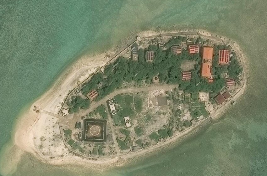
Northeast Cay, also known as Parola Island ( fil, Pulo ng Parola, lit=Island of heLighthouse; Mandarin ; vi, Đảo Song Tử Đông), with a land area of , is the fifth largest of the naturally occurring Spratly Islands and the third largest of the Philippine-occupied islands. It is part of the North Danger Reef and is located to the northwest of Dangerous Ground. It is north of Vietnamese-occupied Southwest Cay ( tl, Pugad), and they are visible from each other. It is located northwest of Philippine-occupied Thitu Island (Pag-asa), and is administered by the Philippines as part of Kalayaan, Palawan. The island is also claimed by the People's Republic of China, the Republic of China (Taiwan) and Vietnam. Environment Some of the cay's outcrops are visible on its western side. It has high salinity groundwater and vegetation is limited to beach type of plants. The corals around the island were mostly destroyed by dynamite and cyanide fishing methods. It is covered with grass ... [...More Info...] [...Related Items...] OR: [Wikipedia] [Google] [Baidu] |
Flat Island (Spratly)
Flat Island, also known as Patag Island ( fil, Pulo ng Patag; Mandarin ; vi, Đảo Bình Nguyên), is the second smallest of the natural Spratly Islands. It has an area of , and is about north of Philippine-occupied Nanshan Island, both of which are located on the expansive but otherwise submerged Flat Island Bank in the NE of Dangerous Ground. It is the sixth largest of the Philippine-occupied Spratly islands and is administered by the Philippines as part of Kalayaan, Palawan. The island is also claimed by the People's Republic of China, the Republic of China (Taiwan), and Vietnam. Environment The island is a low, flat, sandy cay, , and is subject to erosion. It changes its shape seasonally. The sand build up depends largely on the direction of prevailing winds and waves; it has taken an elongated shape for some years, the shape of a crescent moon for a few years, and the shape of a letter "S". Like Lankiam Cay, it is barren of any vegetation. No underground water source has ... [...More Info...] [...Related Items...] OR: [Wikipedia] [Google] [Baidu] |
Central London Reef
Central London Reef ( tl, Bahura ng Gitnang Quezon); Trường Sa Đông Island ( vi, Đảo Trường Sa Đông); Mandarin , is a reef on the central part of the London Reefs of the Spratly Islands in the South China Sea. The reef has been occupied by Vietnam since 1978. It is also claimed by China (PRC), the Philippines, Vietnam, and Taiwan (ROC) Taiwan, officially the Republic of China (ROC), is a country in East Asia, at the junction of the East and South China Seas in the northwestern Pacific Ocean, with the People's Republic of China (PRC) to the northwest, Japan to the northeas .... See also * Spratly Islands dispute References External linksMaritime Transparency Initiative Island Tracker {{island-stub Islands of the Spratly Islands London Reefs ... [...More Info...] [...Related Items...] OR: [Wikipedia] [Google] [Baidu] |
Business Insider
''Insider'', previously named ''Business Insider'' (''BI''), is an American financial and business news website founded in 2007. Since 2015, a majority stake in ''Business Insider''s parent company Insider Inc. has been owned by the German publishing house Axel Springer. It operates several international editions, including one in the United Kingdom. ''Insider'' publishes original reporting and aggregates material from other outlets. , it maintained a liberal policy on the use of anonymous sources. It has also published native advertising and granted sponsors editorial control of its content. The outlet has been nominated for several awards, but is criticized for using factually incorrect clickbait headlines to attract viewership. In 2015, Axel Springer SE acquired 88 percent of the stake in Insider Inc. for $343 million (€306 million), implying a total valuation of $442 million. In February 2021, the brand was renamed simply ''Insider''. History ''Busi ... [...More Info...] [...Related Items...] OR: [Wikipedia] [Google] [Baidu] |
London Reefs
The London Reefs are located between and ( and ) in the Spratly Islands of the South China Sea. The four major features within the area (Central London Reef, Cuarteron Reef, East London Reef, and West London Reef West London Reef ( tl, Bahura ng Kanlurang Quezon); West Reef ( vi, Đá Tây); Mandarin , is a reef on the western part of the London Reefs of the Spratly Islands in the South China Sea. The reef has been occupied by Vietnam since 1987. It is ...), are known by many names:- Version dated 19 August 2011 is available at: References Reefs of the Spratly Islands {{SEAsia-geo-stub ... [...More Info...] [...Related Items...] OR: [Wikipedia] [Google] [Baidu] |
West London Reef
West London Reef ( tl, Bahura ng Kanlurang Quezon); West Reef ( vi, Đá Tây); Mandarin , is a reef on the western part of the London Reefs of the Spratly Islands in the South China Sea. The reef has been occupied by Vietnam since 1987. It is also claimed by China (PRC), the Philippines, Vietnam, and Taiwan (ROC) Taiwan, officially the Republic of China (ROC), is a country in East Asia, at the junction of the East and South China Seas in the northwestern Pacific Ocean, with the People's Republic of China (PRC) to the northwest, Japan to the northeas .... See also * Spratly Islands dispute References External linksMaritime Transparency Initiative Island Tracker {{island-stub Reefs of the Spratly Islands Reefs of Vietnam London Reefs ... [...More Info...] [...Related Items...] OR: [Wikipedia] [Google] [Baidu] |
Grierson Reef
Grierson Reef ( tl, Pulo ng Julian Felipe); Sinh Ton Dong Island ( vi, Đảo Sinh Tồn Đông); Mandarin , is a cay on the eastern part of the Union Banks of the Spratly Islands in the South China Sea. The island has been occupied by Vietnam since 1978. It is also claimed by China (PRC), the Philippines, Vietnam, and Taiwan (ROC) Taiwan, officially the Republic of China (ROC), is a country in East Asia, at the junction of the East and South China Seas in the northwestern Pacific Ocean, with the People's Republic of China (PRC) to the northwest, Japan to the northeas .... See also * Spratly Islands dispute References External linksAsia Maritime Transparency Initiative Island Tracker {{island-stub Islands of the Spratly Islands Islands of Vietnam Union Banks ... [...More Info...] [...Related Items...] OR: [Wikipedia] [Google] [Baidu] |
Amboyna Cay
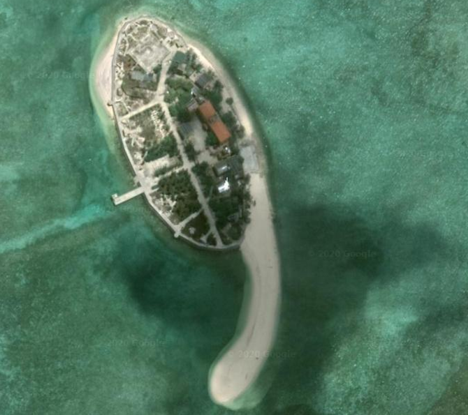
Amboyna Cay, also known as vi, Đảo An Bang; ms, Pulau Amboyna Kecil; Datu Kalantiaw Island ( tl, Pulo ng Datu Kalantiaw, lit=Island of Datu Kalantiaw); Mandarin , and other names, is an island of the Spratly Islands group in the South China Sea located just outside (SW) of the southwest of Dangerous Ground. It is SW of Barque Canada Reef, south of the London Reefs, and NW of Swallow Reef Swallow Reef, also known as ms, Pulau Layang-Layang, lit=; vi, Đá Hoa Lau; Mandarin ; Celerio Reef ( tl, Bahura ng Celerio, lit=), is an oceanic atoll of the Spratly Islands administered by Malaysia, which is situated approximately northwest .... With an area of , it is the List of Spratly Islands by area, thirteenth largest naturally occurring Spratly island and the sixth largest amongst those occupied by Vietnam. The island has two parts: the eastern part consists of sand and coral, and the west part is covered with guano. It has a fringing reef. An obelisk, about high, stands on ... [...More Info...] [...Related Items...] OR: [Wikipedia] [Google] [Baidu] |
Namyit Island
Namyit Island, also known as vi, Đảo Nam Yết; Binago Island ( tl, Pulo ng Binago, lit=Island of Changed); Mandarin , is the third-largest island on Tizard Bank in the northwest of the Spratly Islands in South China Sea. With an area of , it is the twelfth-largest naturally-occurring Spratly island, and the fifth-largest among the Vietnamese-administered islands. The island is also claimed by China (PRC), the Philippines, and Taiwan (ROC). History in the 20th century Although two South Vietnamese warships (the HQ-04 ''Tuy Dong'' and HQ-05 ''Tay Ket'') stopped at Namyit Island in 1962, South Vietnamese troops did not set up a permanent garrison on the islet until August 1973. On 6 September 1973, the Republic of Vietnam's Ministry of the Interior signed Decree No. 420-BNV/HCĐP/26 merging some Spratly islands, including Namyit, into Phuoc Hai Commune, Dat Do District, Phuoc Tuy Province. South Vietnam continued to administer the entity until 27 April 1975 when their troops ... [...More Info...] [...Related Items...] OR: [Wikipedia] [Google] [Baidu] |
Loaita Island
Loaita Island also known as Kota Island ( fil, Pulo ng Kota; Mandarin , and vi, Đảo Loại Ta), with an area of -- is the tenth largest of the naturally-occurring Spratly Islands, and the fifth largest of the Philippine-occupied islands. It is located just to the west of the northern part of Dangerous Ground, and is southeast of Philippine-occupied Thitu Island ''(Pag-asa)'' and north-northeast of Taiwan-occupied Itu Aba Island. The island is administered by the Philippines as part of Kalayaan, Palawan. The island is also claimed by the People's Republic of China, the Republic of China (Taiwan) and Vietnam. Environment The island fringes the Loaita Bank, shoals and reefs. Its calcarenite outcrop is visible along its western side at low tide. The present shape of the island indicates sand buildup along its eastern side. The anchor-shaped side will eventually connect with the northern portion as the sand buildup continues, thereby creating another mini-lagoon in the proce ... [...More Info...] [...Related Items...] OR: [Wikipedia] [Google] [Baidu] |
Sand Cay
A cay ( ), also spelled caye or key, is a small, low-elevation, sandy island on the surface of a coral reef. Cays occur in tropical environments throughout the Pacific, Atlantic, and Indian Oceans, including in the Caribbean and on the Great Barrier Reef and Belize Barrier Reef. Etymology The 1492 indigenous people of the Bahamas were called " Lucayan", an Anglicization of the Spanish ''Lucayos'', derived in turn from the Taíno ''Lukku-Cairi'' (which the people used for themselves), meaning "people of the islands". The Taíno word for "island", ''cairi'', became ''cayo'' in Spanish and "cay" in English (spelled "key" in American English, "caye" in Belizean English). Formation and composition A cay forms when ocean currents transport loose sediment across the surface of a reef to where the current slows or converges with another current, releasing its sediment load. Gradually, layers of deposited sediment build up on the reef surface – a '' depositional node''. Such nod ... [...More Info...] [...Related Items...] OR: [Wikipedia] [Google] [Baidu] |


