|
Intersection Daylighting
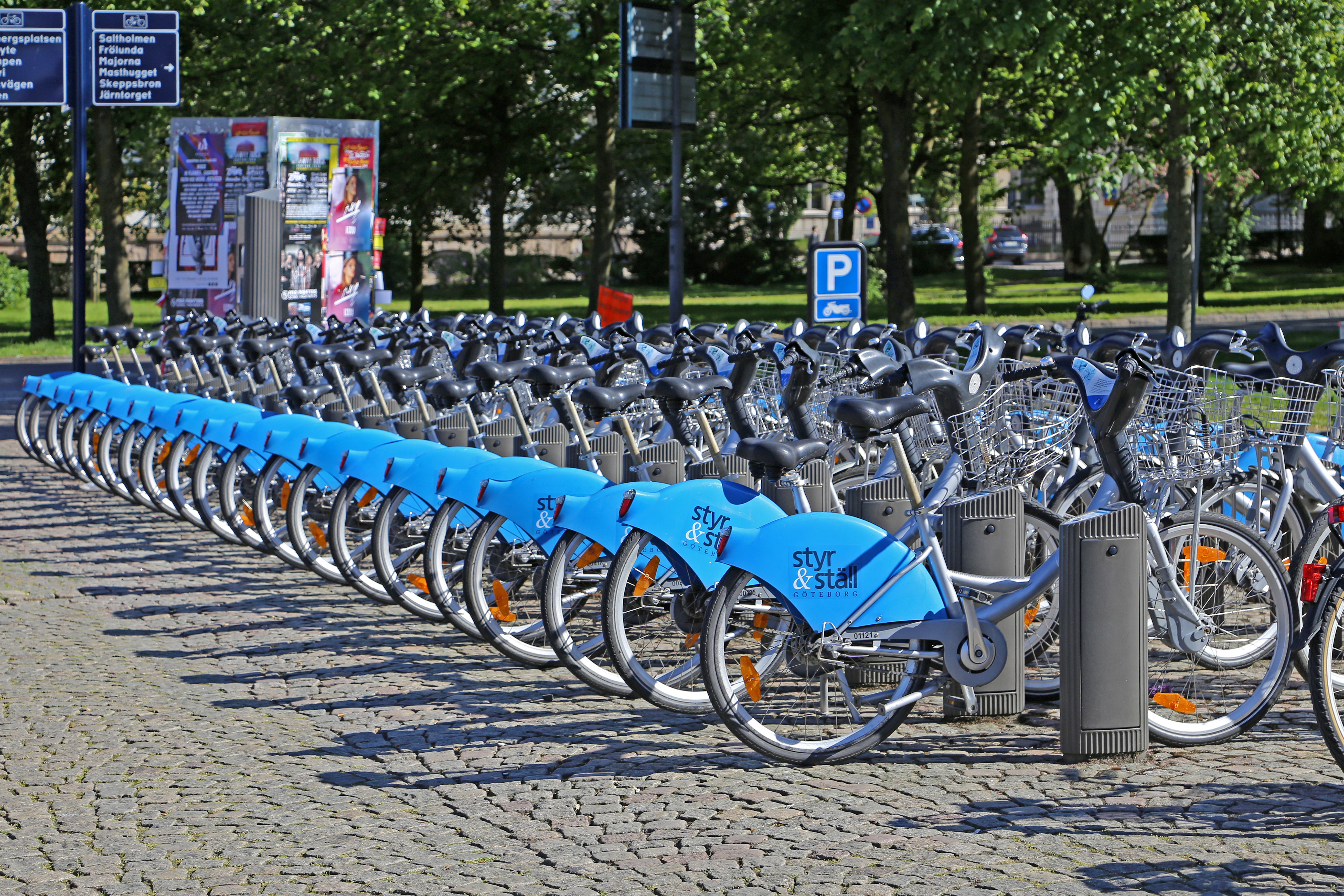
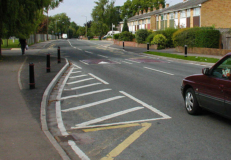
Intersection daylighting, or simply daylighting, is an Transportation planning, urban design strategy to enhance road safety, safety at intersections by improving visibility. About 40-60% of pedestrian and cyclist injuries occur at intersections. Daylighting reduces collisions by removing obstructions that prevent drivers from seeing other cars, pedestrians, bicyclists, and other road users. The National Association of City Transportation Officials recommends daylighting by preventing cars from parking within of an intersection. If parking is merely disallowed by law or signage, drivers may not always comply, so it is best to replace parking with curb extensions or other physical infrastructure that do not impede visibility, like planters, granite blocks, or bike share stations. Many jurisdictions, such as New York State (excluding New York City) and Pennsylvania disallow parking near all intersections. In such cases, further daylighting typically involves safety improvements ... [...More Info...] [...Related Items...] OR: [Wikipedia] [Google] [Baidu] |
Transportation Planning
Transportation planning is the process of defining future policies, goals, investments, and spatial planning designs to prepare for future needs to move people and goods to destinations. As practiced today, it is a collaborative process that incorporates the input of many stakeholders including various government agencies, the public and private businesses. Transportation planners apply a multi-modal and/or comprehensive approach to analyzing the wide range of alternatives and impacts on the transportation system to influence beneficial outcomes. Transportation planning is also commonly referred to as transport planning internationally, and is involved with the evaluation, assessment, design, and siting of transport facilities (generally streets, highways, bike lanes, and public transport lines). Models and sustainability Transportation planning, or transport planning, has historically followed the rational planning model of defining goals and objectives, identifying ... [...More Info...] [...Related Items...] OR: [Wikipedia] [Google] [Baidu] |
Road Safety
Road traffic safety refers to the methods and measures, such as traffic calming, to prevent road users from being killed or seriously injured. Typical road users include pedestrians, cyclists, Driving, motorists, passengers of vehicles, and passengers of on-road public transport, mainly buses and trams. Best practices in modern road safety strategy: As sustainable solutions for classes of road safety have not been identified, particularly low-traffic rural and remote roads, a hierarchy of control should be applied, similar to classifications used to improve occupational safety and health. At the highest level is sustainable prevention of serious injury and death crashes, with sustainable requiring all key result areas to be considered. At the second level is real-time risk reduction, which involves providing users at severe risk with a specific warning to enable them to take mitigating action. The third level is about reducing the crash risk which involves applying the road ... [...More Info...] [...Related Items...] OR: [Wikipedia] [Google] [Baidu] |
National Association Of City Transportation Officials
The National Association of City Transportation Officials (NACTO) is a coalition of the Departments of Transportation in North American cities. Founded in 1996, NACTO has participated in a number of research initiatives dealing with surface transportation in urban areas. Past campaigns have focused on bicycling, bus rapid transit, light rail, bike share, and freight. Its design guides have gained the endorsement of numerous cities, states, and other organizations, in addition to gaining FHWA acceptance for use in conjunction with other mandated guidance and resources. NACTO is headquartered in New York City. Designing Cities Conference Since 2012, NACTO has held an annual Designing Cities Conference, convening hundreds of transportation leaders and practitioners from across North America to discuss key trends in urban street design and transportation policy. Conference sites *2012: New York City *2013: Phoenix *2014: San Francisco *2015: Austin *2016: Seattle *2017: Chic ... [...More Info...] [...Related Items...] OR: [Wikipedia] [Google] [Baidu] |
Curb Extension
A curb extension (or also neckdown, kerb extension, bulb-out, bump-out, kerb build-out, nib, elephant ear, curb bulge, curb bulb, or blister) is a traffic calming measure which widens the sidewalk for a short distance. This reduces the crossing distance and allows pedestrians and drivers to see each other when parked vehicles would otherwise block visibility. The practice of banning car parking near intersections (with or without a curb extension) is referred to as daylighting the intersection. A curb extension is formed by an angled narrowing of the roadway and a widening of the sidewalk. This is often accompanied by an area of enhanced restrictions (such as a "no stopping" or "no parking" zone) and the appropriate visual reinforcement. This is achieved using painted road markings (e.g. lines, coloured areas, or chevrons), barriers, bollards, or the addition of pavement or street furniture (e.g. planters, street lights, or benches). Curb extensions are often used in c ... [...More Info...] [...Related Items...] OR: [Wikipedia] [Google] [Baidu] |
Bike Share
A bicycle-sharing system, bike share program, public bicycle scheme, or public bike share (PBS) scheme, is a shared transport service where bicycles are available for shared use by individuals at low cost. The programmes themselves include both docking and dockless systems, where docking systems allow users to rent a bike from a dock, i.e., a technology-enabled bicycle rack and return at another node or dock within the system – and dockless systems, which offer a node-free system relying on smart technology. In either format, systems may incorporate smartphone web mapping to locate available bikes and docks. In July 2020, Google Maps began including bike share systems in its route recommendations. With its antecedents in grassroots mid-1960s efforts; by 2022, approximately 3,000 cities worldwide offer bike-sharing systems, e.g., Dubai, New York, Paris, Mexico City, Montreal and Barcelona. History The first bike sharing projects were initiated by various sources, such as ... [...More Info...] [...Related Items...] OR: [Wikipedia] [Google] [Baidu] |
Traffic Calming
Traffic calming uses physical design and other measures to improve safety for motorists, car drivers, pedestrians and bicycle-friendly, cyclists. It has become a tool to combat speeding and other unsafe behaviours of drivers. It aims to encourage safer, more responsible driving and potentially reduce traffic flow. Urban planners and Traffic engineering (transportation), traffic engineers have many strategies for traffic calming, including road diet, narrowed roads and speed humps. Such measures are common in Australia and Europe (especially Northern Europe), but less so in North America. Traffic calming is a calque (literal translation) of the German word – the term's first published use in English was in 1985 by Carmen Hass-Klau. History In its early development in the UK in the 1930s, traffic calming was based on the idea that residential areas should be protected from through-traffic. Subsequently, it became valued for its ability to improve pedestrian safety and redu ... [...More Info...] [...Related Items...] OR: [Wikipedia] [Google] [Baidu] |
Curb Extension
A curb extension (or also neckdown, kerb extension, bulb-out, bump-out, kerb build-out, nib, elephant ear, curb bulge, curb bulb, or blister) is a traffic calming measure which widens the sidewalk for a short distance. This reduces the crossing distance and allows pedestrians and drivers to see each other when parked vehicles would otherwise block visibility. The practice of banning car parking near intersections (with or without a curb extension) is referred to as daylighting the intersection. A curb extension is formed by an angled narrowing of the roadway and a widening of the sidewalk. This is often accompanied by an area of enhanced restrictions (such as a "no stopping" or "no parking" zone) and the appropriate visual reinforcement. This is achieved using painted road markings (e.g. lines, coloured areas, or chevrons), barriers, bollards, or the addition of pavement or street furniture (e.g. planters, street lights, or benches). Curb extensions are often used in c ... [...More Info...] [...Related Items...] OR: [Wikipedia] [Google] [Baidu] |
Complete Streets
Complete streets is a transportation policy and design approach that requires streets to be planned, designed, operated and maintained to enable safe, convenient and comfortable travel and access for users of all ages and abilities regardless of their mode of transportation. Complete Streets allow for safe travel by those walking, cycling, driving automobiles, riding public transportation, or delivering goods. The term is often used by transportation advocates, urban planners, traffic and highway engineers, public health practitioners, and community members in the United States and Canada. Complete Streets are promoted as offering improved safety, health, economic, and environmental outcomes. Complete Streets emphasize the importance of safe access for all users, not just automobiles. Related concepts include living streets, Woonerf, and home zones. History After World War II, many communities in the United States were designed to facilitate easy and fast access to destinat ... [...More Info...] [...Related Items...] OR: [Wikipedia] [Google] [Baidu] |
Urban Design
Urban design is an approach to the design of buildings and the spaces between them that focuses on specific design processes and outcomes based on geographical location. In addition to designing and shaping the physical features of towns, city, cities, and regional spaces, urban design considers 'bigger picture' issues of economic, social and environmental value and social design. The scope of a project can range from a local street or public space to an entire city and surrounding areas. Urban designers connect the fields of architecture, landscape architecture and urban planning to better organize local and community environments' dependent upon geographical location. Some important focuses of urban design on this page include its historical impact, paradigm shifts, its interdisciplinary nature, and issues related to urban design. Theory Urban design deals with the larger scale of groups of buildings, infrastructure, streets, and public spaces, entire neighbourhoods and distr ... [...More Info...] [...Related Items...] OR: [Wikipedia] [Google] [Baidu] |


