|
Forest Of Tronçais
The Forest of Tronçais (french: Forêt de Tronçais, ) is a national forest comprising in the Allier department of central France. It is managed by the National Forests Office (ONF). Its oaks, planted by Louis XIV's minister Jean-Baptiste Colbert to supply the French Navy, constitute one of the principal stands of oaks in Europe. Within the forest boundaries are the communes of Braize, Cérilly, Isle-et-Bardais, Le Brethon, Meaulne-Vitray, Saint-Bonnet-Tronçais, Urçay and Valigny. It is mainly made up of sessile oak. It also contains of ponds and is deemed by many as the most beautiful oakwood in Europe.ONF (juillet 2011La sylviculture du chêne à Tronçais La sylviculture du chêne à Tronçais (document distribué à l'occasion d'une visite lors de l'assemblée générale de la Société des amis de la forêt de Tronçais Geography The Forest of Tronçais is located in the (INF) of Boischaut et Champagne Berrichonne. The forest constitutes the most part of the ... [...More Info...] [...Related Items...] OR: [Wikipedia] [Google] [Baidu] |
Allier
Allier ( , , ; oc, Alèir) is a department in the Auvergne-Rhône-Alpes region that borders Cher to the west, Nièvre to the north, Saône-et-Loire and Loire to the east, Puy-de-Dôme to the south, and Creuse to the south-west. Named after the river Allier, it had a population of 335,975 in 2019.Populations légales 2019: 03 Allier INSEE Moulins is the prefecture; Montluçon and are the [...More Info...] [...Related Items...] OR: [Wikipedia] [Google] [Baidu] |
Meaulne-Vitray
Meaulne-Vitray () is a commune in the department of Allier, central France. The municipality was established on 1 January 2017 by merger of the former communes of Meaulne (the seat) and Vitray. History In an effort to guarantee the maintenances of public services in the face of the reduction in state donanations, the , the communes of Meaulne and Vitray — which did not have a church, cemetery, and no longer a school, in addition to relying on infrastructure from Meaulne — fused to become the commune nouvelle of Meaulne-Vitray. Politics and administration Administrative and electoral attachments Meaulne-Vitray is situated in the Montluçon arrondissement in the department of Allier. Within the department, the commune is attached to the Canton of Bourbon-l'Archambault. For legislative elections to the National Assembly, Meaulne-Vitray is part of Allier's 2nd legislative constituency. Intercommunality Since its inception the commune has been a part of the communauté ... [...More Info...] [...Related Items...] OR: [Wikipedia] [Google] [Baidu] |
Triassic
The Triassic ( ) is a geologic period and system which spans 50.6 million years from the end of the Permian Period 251.902 million years ago ( Mya), to the beginning of the Jurassic Period 201.36 Mya. The Triassic is the first and shortest period of the Mesozoic Era. Both the start and end of the period are marked by major extinction events. The Triassic Period is subdivided into three epochs: Early Triassic, Middle Triassic and Late Triassic. The Triassic began in the wake of the Permian–Triassic extinction event, which left the Earth's biosphere impoverished; it was well into the middle of the Triassic before life recovered its former diversity. Three categories of organisms can be distinguished in the Triassic record: survivors from the extinction event, new groups that flourished briefly, and other new groups that went on to dominate the Mesozoic Era. Reptiles, especially archosaurs, were the chief terrestrial vertebrates during this time. A specialized subgroup of archo ... [...More Info...] [...Related Items...] OR: [Wikipedia] [Google] [Baidu] |
Quaternary
The Quaternary ( ) is the current and most recent of the three periods of the Cenozoic Era in the geologic time scale of the International Commission on Stratigraphy (ICS). It follows the Neogene Period and spans from 2.58 million years ago to the present. The Quaternary Period is divided into two epochs: the Pleistocene (2.58 million years ago to 11.7 thousand years ago) and the Holocene (11.7 thousand years ago to today, although a third epoch, the Anthropocene, has been proposed but is not yet officially recognised by the ICS). The Quaternary Period is typically defined by the cyclic growth and decay of continental ice sheets related to the Milankovitch cycles and the associated climate and environmental changes that they caused. Research history In 1759 Giovanni Arduino proposed that the geological strata of northern Italy could be divided into four successive formations or "orders" ( it, quattro ordini). The term "quaternary" was introduced by Jules Desnoye ... [...More Info...] [...Related Items...] OR: [Wikipedia] [Google] [Baidu] |
Geologic Time Scale
The geologic time scale, or geological time scale, (GTS) is a representation of time based on the rock record of Earth. It is a system of chronological dating that uses chronostratigraphy (the process of relating strata to time) and geochronology (scientific branch of geology that aims to determine the age of rocks). It is used primarily by Earth scientists (including geologists, paleontologists, geophysicists, geochemists, and paleoclimatologists) to describe the timing and relationships of events in geologic history. The time scale has been developed through the study of rock layers and the observation of their relationships and identifying features such as lithologies, paleomagnetic properties, and fossils. The definition of standardized international units of geologic time is the responsibility of the International Commission on Stratigraphy (ICS), a constituent body of the International Union of Geological Sciences (IUGS), whose primary objective is to precisely define ... [...More Info...] [...Related Items...] OR: [Wikipedia] [Google] [Baidu] |
Paris Basin
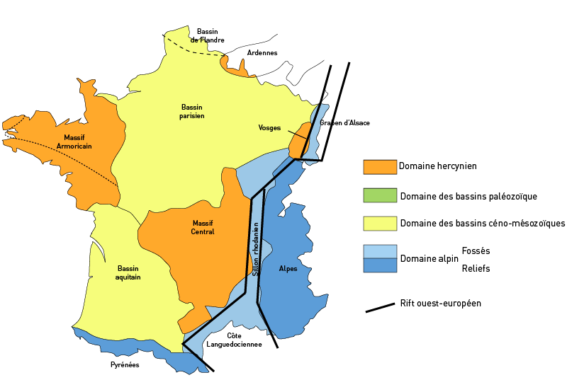
The Paris Basin is one of the major geological regions of France. It developed since the Triassic over remnant uplands of the Variscan orogeny (Hercynian orogeny). The sedimentary basin, no longer a single drainage basin, is a large sag in the craton, bordered by the Armorican Massif to the west, the Ardennes-Brabant axis to the north, the Massif des Vosges to the east, and the Massif Central to the south.Duval, B.C., 1992, Villeperdue Field, In Giant Oil and Gas Fields of the Decade, 1978-1988, AAPG Memoir 54, Halbouty, M.T., editor, Tulsa: American Association of Petroleum Geologists, Extent The region usually regarded as the Paris Basin is rather smaller than the area formed by the geological structure. The former occupies the centre of the northern half of the country, excluding Eastern France. The latter extends from the hills just south of Calais to Poitiers and from Caen to the brink of the middle Rhine Valley, east of Saarbrücken. Geography The landscape is one of ... [...More Info...] [...Related Items...] OR: [Wikipedia] [Google] [Baidu] |
Vitray
Vitray () is a former commune in the Allier department in Auvergne-Rhône-Alpes in central France. On 1 January 2017, it was merged into the new commune Meaulne-Vitray. 19 July 2016 Population See also *Communes of the Allier department
The following is a list of the 317 communes of the Allier department of France.
Intercommunalities
The communes cooperate in the following intercommunalities (as of 2020):
[...More Info...] [...Related Items...] OR: [Wikipedia] [Google] [Baidu] |
Meaulne
Meaulne () is a former commune in the Allier department in central France. On 1 January 2017, it was merged into the new commune Meaulne-Vitray. 19 July 2016 Population See also *Communes of the Allier department
The following is a list of the 317 communes of the Allier department of France.
Intercommunalities
The communes cooperate in the following intercommunalities (as of 2020):
[...More Info...] [...Related Items...] OR: [Wikipedia] [Google] [Baidu] |
Bourbonnais
Bourbonnais () was a historic province in the centre of France that corresponds to the modern ''département'' of Allier, along with part of the ''département'' of Cher. Its capital was Moulins. History The title of the ruler of Bourbonnais between 913 and 1327, was Sire de Bourbon (Seigneur de Bourbon). The first lord of Bourbonnais known by name was Adhémar (or ). Aymon's father was Aymar (894-953), sire of Souvigny, his only son with Ermengarde. Aymar lived during the reign of Charles the Simple who, in 913, gave him fiefs on the river Allier in which would become Bourbonnais. He acquired the castle of Bourbon (today Bourbon-l'Archambault). Almost all early lords took the name d'Archambaud, after the palace, but later the family became known as the "House of Bourbon". The first House of Bourbon ended in 1196, with the death of Archambault VII, who had only one heir, Mathilde of Bourbon. She married Guy II of Dampierre, who added Montluçon to the possessions of the lor ... [...More Info...] [...Related Items...] OR: [Wikipedia] [Google] [Baidu] |
Massif Central
The (; oc, Massís Central, ; literally ''"Central Massif"'') is a highland region in south-central France, consisting of mountains and plateaus. It covers about 15% of mainland France. Subject to volcanism that has subsided in the last 10,000 years, these central mountains are separated from the Alps by a deep north–south cleft created by the Rhône river and known in French as the ' (literally "Rhône furrow"). The region was a barrier to transport within France until the opening of the A75 motorway, which not only made north–south travel easier, but also opened access to the massif itself. Geography and geology The is an old massif, formed during the Variscan orogeny, consisting mostly of granitic and metamorphic rocks. It was powerfully raised and made to look geologically younger in the eastern section by the uplift of the Alps during the Paleogene period and in the southern section by the uplift of the Pyrenees. The massif thus presents a strongly asymmet ... [...More Info...] [...Related Items...] OR: [Wikipedia] [Google] [Baidu] |
Highland
Highlands or uplands are areas of high elevation such as a mountainous region, elevated mountainous plateau or high hills. Generally speaking, upland (or uplands) refers to ranges of hills, typically from up to while highland (or highlands) is usually reserved for ranges of low mountains. However, the two terms are sometimes interchangeable. Highlands internationally Probably the best-known area officially or unofficially referred to as ''highlands'' in the Anglosphere is the Scottish Highlands in northern Scotland, the mountainous region north and west of the Highland Boundary Fault. The Highland council area is a local government area in the Scottish Highlands and Britain's largest local government area. Other highland or upland areas reaching 400-500 m or higher in the United Kingdom include the Southern Uplands in Scotland, the Pennines, North York Moors, Dartmoor and Exmoor in England, and the Cambrian Mountains in Wales. Many countries and regions also have areas referre ... [...More Info...] [...Related Items...] OR: [Wikipedia] [Google] [Baidu] |
Forêt DeTronçais Près Du Chêne Carré
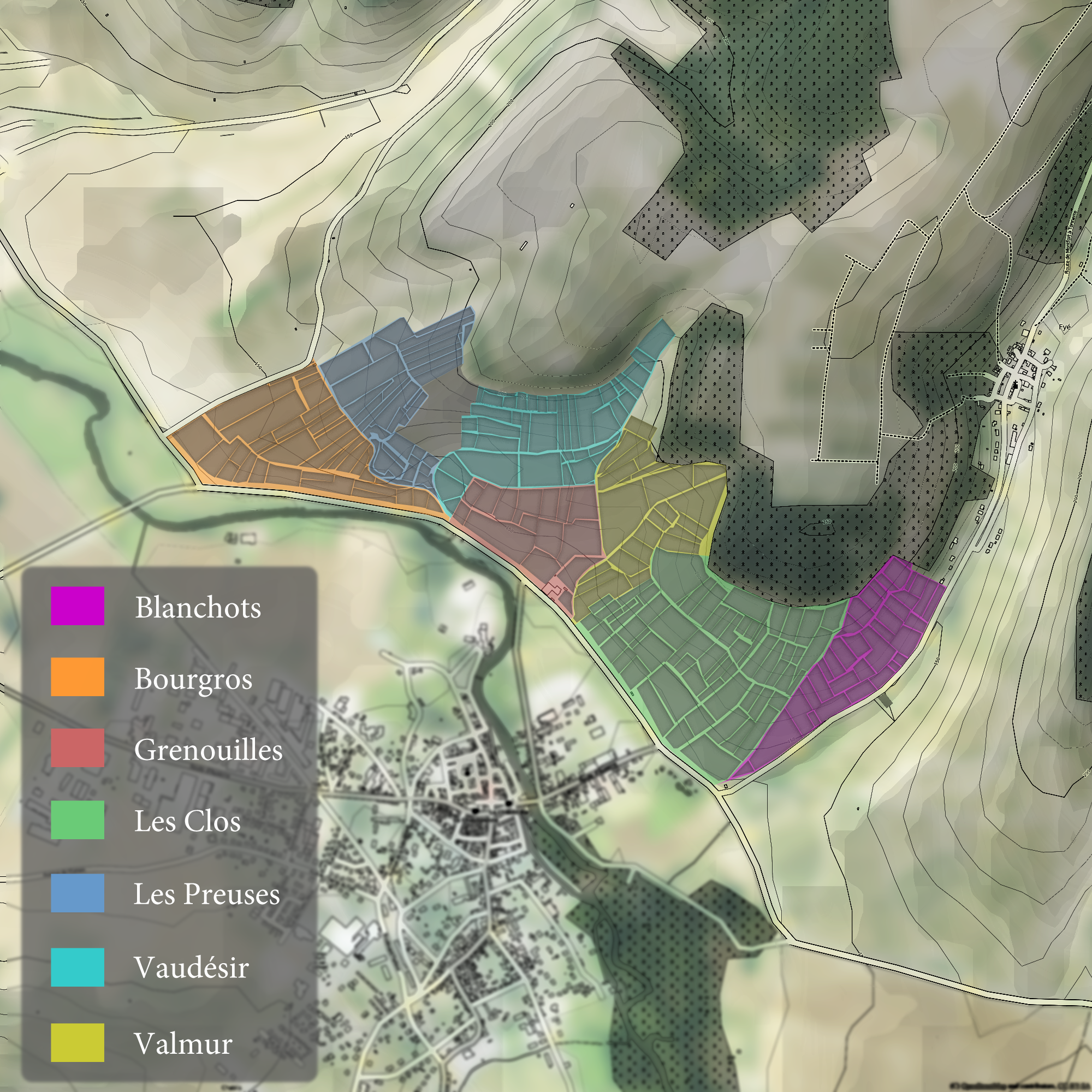
The Chablis region of Burgundy is classified according to four tiers of ''Appellation d'origine contrôlée'' (AOC) designation. The top two are the crus of Chablis and include the 7 Grand cru vineyards followed by the lower Premier crus. Wines made entirely from fruit from these vineyards are entitled to list their wines as ''cru classé'' Chablis on the wine label. Below these tiers are the lower designations of basic Chablis AOC and Petit Chablis. Soil quality and hill slope play a major role in delineating the differences. Many of the Premier Crus, and all the Grand Crus vineyards, are planted along valley of the Serein river as it flows into the Yonne with the best sites located on a southwest facing slope that receives the maximum amount of sun exposure. All of Chablis' Grand Cru vineyards and many of their better Premier Cru vineyards are planted on primarily Kimmeridgean soil (a composition of limestone, clay and tiny fossilized oyster shells) which is believed to impart m ... [...More Info...] [...Related Items...] OR: [Wikipedia] [Google] [Baidu] |


