|
Echo Overhang
The Lemon technique is a method used by meteorologists using weather radar to determine the relative strength of thunderstorm cells in a vertically wind shear, sheared environment. It is named for Leslie R. Lemon, the co-creator of the current conceptual model of a supercell. The Lemon technique is largely a continuation of work by Keith A. Browning, who first identified and named the supercell.; The method focuses on updrafts and uses weather radar to measure quantities such as height (''echo tops''), reflectivity (such as morphology and gradient), and location to show features and trends described by Lemon. These features include: * ''Updraft tilt'' - The tilted updraft (vertical orientation) of the main updraft is an indication of the strength of the updraft, with nearly vertical tilts indicating stronger updrafts. * ''Echo overhang'' - In intense thunderstorms, an area of very strong reflectivity atop the weak echo region and on the low-level inflow inside side of the storm. ... [...More Info...] [...Related Items...] OR: [Wikipedia] [Google] [Baidu] |
Thunderstorm
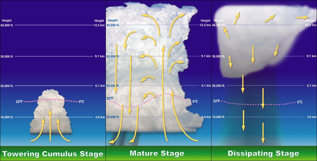
A thunderstorm, also known as an electrical storm or a lightning storm, is a storm characterized by the presence of lightning and its acoustics, acoustic effect on the Earth's atmosphere, known as thunder. Relatively weak thunderstorms are sometimes called thundershowers. Thunderstorms occur in cumulonimbus clouds. They are usually accompanied by strong winds and often produce Heavy rain (meteorology), heavy rain and sometimes Thundersnow, snow, Ice pellets, sleet, or hail, but some thunderstorms can produce little or Dry thunderstorm, no precipitation at all. Thunderstorms may thunderstorm training, line up in a series or become a rainband, known as a squall line. Strong or #Severe thunderstorms, severe thunderstorms include some of the most dangerous weather phenomena, including large hail, strong winds, and tornadoes. Some of the most persistent severe thunderstorms, known as supercells, rotate as do cyclones. While most thunderstorms move with the mean wind flow thr ... [...More Info...] [...Related Items...] OR: [Wikipedia] [Google] [Baidu] |
Tilted Updraft
A tilted updraft (also known as a tilted storm) is a thunderstorm which is not vertically erect. This happens as a result of unidirectional wind shear, or a change in wind speed with height. In such an environment, the top of the updraft is pushed further downstream than the lower parts as a result of stronger winds pushing the top, as it is higher in the atmosphere An atmosphere () is a layer of gases that envelop an astronomical object, held in place by the gravity of the object. A planet retains an atmosphere when the gravity is great and the temperature of the atmosphere is low. A stellar atmosph .... Storms that occur in environments with wind shear are more likely to be severe. References Severe weather and convection {{climate-stub fr:Technique de Lemon#Technique ... [...More Info...] [...Related Items...] OR: [Wikipedia] [Google] [Baidu] |
University Of Illinois
The University of Illinois Urbana-Champaign (UIUC, U of I, Illinois, or University of Illinois) is a public university, public land-grant university, land-grant research university in the Champaign–Urbana metropolitan area, Illinois, United States. Established in 1867, it is the founding campus and Flagship#Colleges and universities in the United States, flagship institution of the University of Illinois System. With over 59,000 students, the University of Illinois is one of the List of United States public university campuses by enrollment, largest public universities by enrollment in the United States. The university contains 16 schools and colleges and offers more than 150 undergraduate and over 100 graduate programs of study. The university holds 651 buildings on and its annual operating budget in 2016 was over $2 billion. The University of Illinois Urbana-Champaign also operates Research Park at the University of Illinois Urbana-Champaign, a research park home to innova ... [...More Info...] [...Related Items...] OR: [Wikipedia] [Google] [Baidu] |
Convective Storm Detection
Convective storm detection is the meteorological observation, and short-term prediction, of deep moist convection (DMC). DMC describes atmospheric conditions producing single or clusters of large vertical extension clouds ranging from cumulus congestus to cumulonimbus, the latter producing thunderstorms associated with lightning and thunder. Those two types of clouds can produce severe weather at the surface and aloft. The ability to discern the presence of deep moist convection in a storm significantly improves meteorologists' capacity to predict and monitor associated phenomena such as tornadoes, large hail, strong winds, and heavy rain leading to flash flooding. It relies on direct eyewitness observations, for example from storm spotters; and on remote sensing, especially weather radar. Some in situ measurements are used for direct detection as well, notably, wind speed reports from surface observation stations. It is part of the ''integrated warning system'', consisting of ... [...More Info...] [...Related Items...] OR: [Wikipedia] [Google] [Baidu] |
Descending Reflectivity Core
A descending reflectivity core (DRC), sometimes referred to as a blob, is a meteorological phenomenon observed in supercell thunderstorms, characterized by a localized, small-scale area of enhanced radar reflectivity that descends from the echo overhang into the lower levels of the storm. Typically found on the right rear flank of supercells, DRCs are significant for their potential role in the development or intensification of low-level rotation within these storms. The descent of DRCs has been associated with the formation and evolution of hook echoes, a key radar signature of supercells, suggesting a complex interplay between these cores and storm dynamics. First identified and studied through mobile Doppler radar observations, DRCs offer a higher resolution perspective than traditional operational radars, enabling a detailed examination of their structure and behavior. However, these observations often lack a broader, larger-scale view, limiting insights into the origin ... [...More Info...] [...Related Items...] OR: [Wikipedia] [Google] [Baidu] |
Doppler Effect
The Doppler effect (also Doppler shift) is the change in the frequency of a wave in relation to an observer who is moving relative to the source of the wave. The ''Doppler effect'' is named after the physicist Christian Doppler, who described the phenomenon in 1842. A common example of Doppler shift is the change of pitch heard when a vehicle sounding a horn approaches and recedes from an observer. Compared to the emitted frequency, the received frequency is higher during the approach, identical at the instant of passing by, and lower during the recession. When the source of the sound wave is moving towards the observer, each successive cycle of the wave is emitted from a position closer to the observer than the previous cycle. Hence, from the observer's perspective, the time between cycles is reduced, meaning the frequency is increased. Conversely, if the source of the sound wave is moving away from the observer, each cycle of the wave is emitted from a position farther from ... [...More Info...] [...Related Items...] OR: [Wikipedia] [Google] [Baidu] |
Mesocyclone
A mesocyclone is a meso-gamma mesoscale (or storm scale) region of rotation ( vortex), typically around in diameter, most often noticed on radar within thunderstorms. In the Northern Hemisphere, it is usually located in the right rear flank (back edge with respect to direction of movement) of a supercell, or often on the eastern, or leading, flank of a high-precipitation variety of supercell. The area overlaid by a mesocyclone’s circulation may be several miles (km) wide, but substantially larger than any tornado that may develop within it, and it is within mesocyclones that intense tornadoes form. Description Mesocyclones are medium-scale vortices of rising and converging air that circulate around a vertical axis. They are most often associated with a local region of low-pressure. Their rotation is (usually) in the same direction as low pressure systems in a given hemisphere: counter-clockwise in the northern, and clockwise in the southern hemisphere, with the only o ... [...More Info...] [...Related Items...] OR: [Wikipedia] [Google] [Baidu] |
Bounded Weak Echo Region
The bounded weak echo region, also known as a BWER or a vault, is a Weather radar, radar signature within a thunderstorm characterized by a local minimum in radar reflectivity at low levels which extends upward into, and is surrounded by higher reflectivities aloft, forming a kind of dome of weak echoes. This feature is associated with a strong updraft and is almost always found in the inflow region of a thunderstorm: it cannot be seen visually. The BWER has been noted on radar imagery of severe thunderstorms since 1973 and has a lightning detection system equivalent known as a ''lightning hole''.Martin J. Murphy and Nicholas W. S. DemetriadesAn Analysis of Lightning Holes in a DFW Supercell Storm Using Total Lightning and Radar Information.Retrieved on 2008-01-08. Description and attributes The BWER is a nearly vertical channel of weak radar echo, surrounded on the sides and top by significantly stronger echoes. The BWER, sometimes called a vault, is related to the strong updra ... [...More Info...] [...Related Items...] OR: [Wikipedia] [Google] [Baidu] |
BWER On Radar Data
The bounded weak echo region, also known as a BWER or a vault, is a radar signature within a thunderstorm characterized by a local minimum in radar reflectivity at low levels which extends upward into, and is surrounded by higher reflectivities aloft, forming a kind of dome of weak echoes. This feature is associated with a strong updraft and is almost always found in the inflow region of a thunderstorm: it cannot be seen visually. The BWER has been noted on radar imagery of severe thunderstorms since 1973 and has a lightning detection system equivalent known as a ''lightning hole''.Martin J. Murphy and Nicholas W. S. DemetriadesAn Analysis of Lightning Holes in a DFW Supercell Storm Using Total Lightning and Radar Information.Retrieved on 2008-01-08. Description and attributes The BWER is a nearly vertical channel of weak radar echo, surrounded on the sides and top by significantly stronger echoes. The BWER, sometimes called a vault, is related to the strong updraft in a severe ... [...More Info...] [...Related Items...] OR: [Wikipedia] [Google] [Baidu] |
Wind Shear
Wind shear (; also written windshear), sometimes referred to as wind gradient, is a difference in wind speed and/or direction over a relatively short distance in the atmosphere. Atmospheric wind shear is normally described as either vertical or horizontal wind shear. Vertical wind shear is a change in wind speed or direction with a change in altitude. Horizontal wind shear is a change in wind speed with a change in lateral position for a given altitude. Wind shear is a microscale meteorological phenomenon occurring over a very small distance, but it can be associated with mesoscale or synoptic scale weather features such as squall lines and cold fronts. It is commonly observed near microbursts and downbursts caused by thunderstorms, fronts, areas of locally higher low-level winds referred to as low-level jets, near mountains, radiation inversions that occur due to clear skies and calm winds, buildings, wind turbines, and sailboats. Wind shear has significant effects on ... [...More Info...] [...Related Items...] OR: [Wikipedia] [Google] [Baidu] |
National Severe Storms Forecast Center
The Storm Prediction Center (SPC) is a US government agency that is part of the National Centers for Environmental Prediction (NCEP), operating under the control of the National Weather Service (NWS), which in turn is part of the National Oceanic and Atmospheric Administration (NOAA) of the United States Department of Commerce (DoC). Headquartered at the National Weather Center in Norman, Oklahoma, the Storm Prediction Center is tasked with forecasting the risk of severe thunderstorms and tornadoes in the contiguous United States. It issues convective outlooks, mesoscale discussions, and watches as a part of this process. Convective outlooks are issued for the following eight days (issued separately for Day 1, Day 2, Day 3, and Days 4–8), and detail the risk of severe thunderstorms and tornadoes during the given forecast period, although tornado, hail and wind details are only available for Days 1 and 2. Day 3 uses a probabilistic scale from a Marginal to Moder ... [...More Info...] [...Related Items...] OR: [Wikipedia] [Google] [Baidu] |
Weather Radar
A weather radar, also called weather surveillance radar (WSR) and Doppler weather radar, is a type of radar used to locate precipitation (meteorology), precipitation, calculate its motion, and estimate its type (rain, snow, hail etc.). Modern weather radars are mostly pulse-Doppler radars, capable of detecting the motion of rain droplets in addition to the intensity of the precipitation. Both types of data can be analyzed to determine the structure of storms and their potential to cause severe weather. During Radar in World War II, World War II, radar operators discovered that weather was causing echoes on their screens, masking potential enemy targets. Techniques were developed to filter them, but scientists began to study the phenomenon. Soon after the war, military surplus, surplus radars were used to detect precipitation. Since then, weather radar has evolved and is used by national weather services, research departments in universities, and in television stations' weather d ... [...More Info...] [...Related Items...] OR: [Wikipedia] [Google] [Baidu] |


