|
Division Of Canberra
The Division of Canberra is an Australian electoral division in the Australian Capital Territory. It is named for the city of Canberra, Australia's national capital, and includes all of central Canberra, Kowen, Majura, as well as part of Weston Creek, Woden Valley, Molonglo Valley, Belconnen, and Jerrabomberra. It is currently held by Alicia Payne of the Labor Party. Geography Since 1984, federal electoral division boundaries in Australia have been determined at redistributions by a redistribution committee appointed by the Australian Electoral Commission. Redistributions occur for the boundaries of divisions in a particular state or territory, and they occur every seven years, or sooner if a state or territory's representation entitlement changes or when divisions of a state or territory are malapportioned. As of 2018, the division of Canberra includes Canberra Central, the Woden Valley suburbs of Curtin, Chifley, Garran and Hughes, the Belconnen suburbs of Aranda, B ... [...More Info...] [...Related Items...] OR: [Wikipedia] [Google] [Baidu] |
Australian Capital Territory
The Australian Capital Territory (commonly abbreviated as ACT), known as the Federal Capital Territory (FCT) until 1938, is a landlocked federal territory of Australia containing the national capital Canberra and some surrounding townships. It is located in southeastern Australian mainland as an enclave completely within the state of New South Wales. Founded after Federation as the seat of government for the new nation, the territory hosts the headquarters of all important institutions of the Australian Government. On 1 January 1901, federation of the colonies of Australia was achieved. Section 125 of the new Australian Constitution provided that land, situated in New South Wales and at least from Sydney, would be ceded to the new federal government. Following discussion and exploration of various areas within New South Wales, the ''Seat of Government Act 1908'' was passed in 1908 which specified a capital in the Yass-Canberra region. The territory was transferred to the ... [...More Info...] [...Related Items...] OR: [Wikipedia] [Google] [Baidu] |
Chifley, Australian Capital Territory
Chifley (postcode: 2606) is a suburb of Canberra, Australia, in the district of Woden Valley. The suburb's area is . It was named after Joseph Benedict Chifley, Prime Minister of Australia from July 1945 to December 1949. The streets of Chifley are named for scientists and educationalists. It is next to the suburbs of Pearce, Lyons and Phillip. Behind it stands Mount Taylor, which is a nature park. It is bordered by Hindmarsh Drive and Melrose Drive. A local shopping centre and Chifley Neighbourhood Oval are located in the suburb. History Chifley was established on 12 May 1966, which was around the same time when the Woden Valley was also established, thus making it one of the original settlement spots in the southern part of Canberra. The ''Districts Ordinance 1966 No. 5'' (Cth) became, after the enactment of the ''Australian Capital Territory (Self-Government) Act'' 1988, the ''Districts Act'' 1966. This Act was subsequently repealed by the ACT Government and the district is ... [...More Info...] [...Related Items...] OR: [Wikipedia] [Google] [Baidu] |
Oaks Estate, Australian Capital Territory
Oaks Estate is a township situated immediately on the northern side of the Australian Capital Territory border abutting the township of Queanbeyan in south-eastern New South Wales, Australia. The estate covers an area of approximately 40 hectares and is bound by the Molonglo River to the north, the Queanbeyan River to the east, 'The Oaks' to the west, and the Queanbeyan-Cooma railway to the south. Oaks Estate is located 12 kilometres from the centre of Canberra. The village is also noteworthy as the nucleus of Queanbeyan's industrial development during the second half of the 19th century. Oaks Estate takes its name from 'The Oaks', which was part of Duntroon, Robert Campbell's farming estate.Monaro Consultants & Burnham Planning (2001), ''Oaks Estate Planning Study'', ACT Government This makes Oaks Estate one of only a few place names in the ACT with significant connections to early colonial times. History Colonial Timothy Beard, a pardoned convict and former innkeeper from ... [...More Info...] [...Related Items...] OR: [Wikipedia] [Google] [Baidu] |
Beard, Australian Capital Territory
Beard is a suburb of Canberra in the District of Jerrabomberra, Australian Capital Territory, named after ex-convict Timothy Beard, the first recorded European settler in the vicinity of modern-day Queanbeyan. History From the time of European settlement until 1942, Beard was primarily pastoral land. In 1942, a contract was awarded to construct a Commonwealth owned abattoir in the area. Work was significantly delayed following a fire that gutted the construction site in June 1943. Sold to private investors in 1969, the Canberra abattoirs operated from 1944 until 1997. A planning study was conducted by the ACT Government in 2004 for a proposed residential development to be known as "Griffin Green", however subsequent studies focused on industrial uses of the land in order to address a shortage of small industrial lots across both the Canberra and Queanbeyan markets. The suburb began as Fyshwick East Industrial Estate in 2009, with developer CIC Australia releasing the first lot ... [...More Info...] [...Related Items...] OR: [Wikipedia] [Google] [Baidu] |
Jerrabomberra (district)
The Jerrabomberra District is a district of Canberra. It is situated to the southeast of South Canberra, south of the Molonglo River, east of Woden Valley and north east of Tuggeranong and west of the New South Wales border. It includes the suburbs of Beard, Hume, Oaks Estate and Symonston and the military communications and logistics facility . At the , it had a total population of 1,240, comprising 559 in Symonston, 430 in Hume (including the Alexander Maconochie Centre) and 251 in Oaks Estate and Beard At the , 13 also lived in ''Harman''. It is named after Jerrabomberra Creek, which runs through it, ''Jerrabomberra'' is derived from the Aboriginal word, meaning "afraid of lightning". Jerrabomberra includes the "urban village" of Oaks Estate, which was formerly part of Queanbeyan, broadacre uses in Symonston (including the headquarters of Geoscience Australia and the Therapeutic Goods Administration), light industry in Hume and Symonston, HMAS ''Harman'' and rural areas. It ... [...More Info...] [...Related Items...] OR: [Wikipedia] [Google] [Baidu] |
Weetangera, Australian Capital Territory
Weetangera () is a suburb in the Belconnen district of Canberra, located within the Australian Capital Territory, Australia. The suburb covers an area of approximately . Located approximately north-west of the city, Weetangera is bounded by Springvale Drive to the south and west, Coulter Drive to the east and Belconnen Way to the north. The Pinnacle Nature Reserve, a Canberra Nature Park is adjacent to the south of the suburb, across Springvale Drive. Etymology Weetangera is named after the original name of the property "Spring Vale", which in turn had been given a name of Aboriginal origin. In 1934, Australian journalist Frederic Slater claimed that the name "Wittanjirra" was an Aboriginal word meaning "to suck, to drink greedily", referring to a spring near the Weetangera Public School. However, Slater does not provide evidence to support this claim. History Aboriginal settlement of the Australian Capital Territory dates back over 20,000 years. Grinding grooves located on ... [...More Info...] [...Related Items...] OR: [Wikipedia] [Google] [Baidu] |
Lawson, Australian Capital Territory
Lawson (postcode: 2617) is a suburb in the Belconnen district of Canberra, located within the Australian Capital Territory, Australia. The suburb is surrounded by Baldwin Drive, Gundaroo Drive and Ginninderra Drive. It lies next to the suburbs of McKellar, Giralang, Kaleen, Bruce and Belconnen. Two intersections were built in 2012 that lead into the suburb's grasslands, prepared for future development on the suburb, one leading off Ginninderra Drive, and another off Baldwin Drive. However, neither intersection continued on further than a few metres. Development was delayed by about two years by Commonwealth environmental clearance processes due to the presence of golden sun moth and native grassland. Construction of roads have commenced and the first residential land was sold on 3 December 2013. The suburb derives its name from Henry Lawson, short story writer and poet. The streets in Lawson are named after aspects of Australia appearing in his writing. A bicycle path runs alo ... [...More Info...] [...Related Items...] OR: [Wikipedia] [Google] [Baidu] |
Kaleen
Kaleen ( or ) is a suburb in the Belconnen district of Canberra, located within the Australian Capital Territory, Australia. The suburb's name means ‘water’ in the language of the Wiradjuri Aboriginal tribe of the central west region of New South Wales. Kaleen was gazetted as a suburb on 15 January 1974. The streets are named after Australian rivers. The suburb is next to Lyneham, Giralang, Lawson and Bruce. It is bordered by Baldwin Drive and Ginninderra Drive. It has several ovals; Kaleen North oval, Kaleen Enclosed oval, Kaleen District Playing Fields and Kaleen South oval, which play host to a number of sports, including soccer, cricket, and rugby. Unusually for a suburb, there are two small shopping centres in Kaleen, both bordering the main street of Maribyrnong Avenue. There is also a larger shopping centre near Kaleen's border with Giralang on Georgina Crescent. The 2XX transmitting station is also located in Kaleen, near the Barton Highway. On the east side of ... [...More Info...] [...Related Items...] OR: [Wikipedia] [Google] [Baidu] |
Hawker, Australian Capital Territory
Hawker () (Postcodes in Australia, postcode: 2614) is a suburb of the Belconnen district of Canberra, located within the Australian Capital Territory, Australia. The suburb of Hawker is named after Charles Hawker (1894–1938), Member of the Australian House of Representatives, House of Representatives from 1929 to 1938 and Federal minister in 1932. Streets in the suburb are named according to the theme of Northern Territory pastoral stations. Features and location The centrepiece of the suburb is a Suburbs of Canberra#Group centres, group centre where there are many small businesses and shops like take aways, a newsagent, a hotel, KFC and Olive at Hawker – Mediterranean Restaurant. The area supports three schools: Hawker Primary School, Belconnen High School and Hawker College (a College#Australia, specialist senior secondary school). Combined, these schools cover students from preschool to Year 12. Hawker is a popular location for sport, and includes the multi-purpose H ... [...More Info...] [...Related Items...] OR: [Wikipedia] [Google] [Baidu] |
Giralang, Australian Capital Territory
Giralang () is a suburb of the Belconnen district of Canberra, located within the Australian Capital Territory, Australia. The suburb is named after the word in the language of the Wiradhuri Aboriginal tribe of the Central West of New South Wales, meaning ''star''. The suburb name was gazetted on 15 January 1974. Streets in Giralang are named after Aboriginal words for stars, astronomers and constellations seen from the southern hemisphere. In the suburb is the Giralang District Playing fields and adjacent Giralang Primary School. The suburb is bordered by Baldwin Drive, William Slim Drive and the Barton Highway. Educational facilities Giralang Primary School was under threat to close in 2006. After completion of the school closure process it was decided that Giralang Primary School will remain open. In 2011, a Jewish mikvah opened in Giralang. An early childhood education and care facility for Jewish children opened in 2013 in the refurbished former Giralang Preschool bui ... [...More Info...] [...Related Items...] OR: [Wikipedia] [Google] [Baidu] |
Cook, Australian Capital Territory
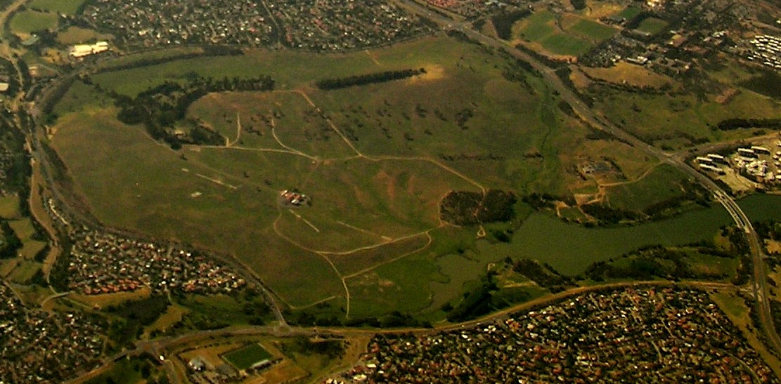
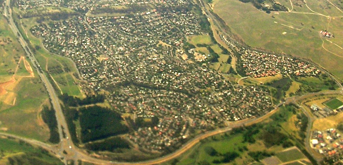
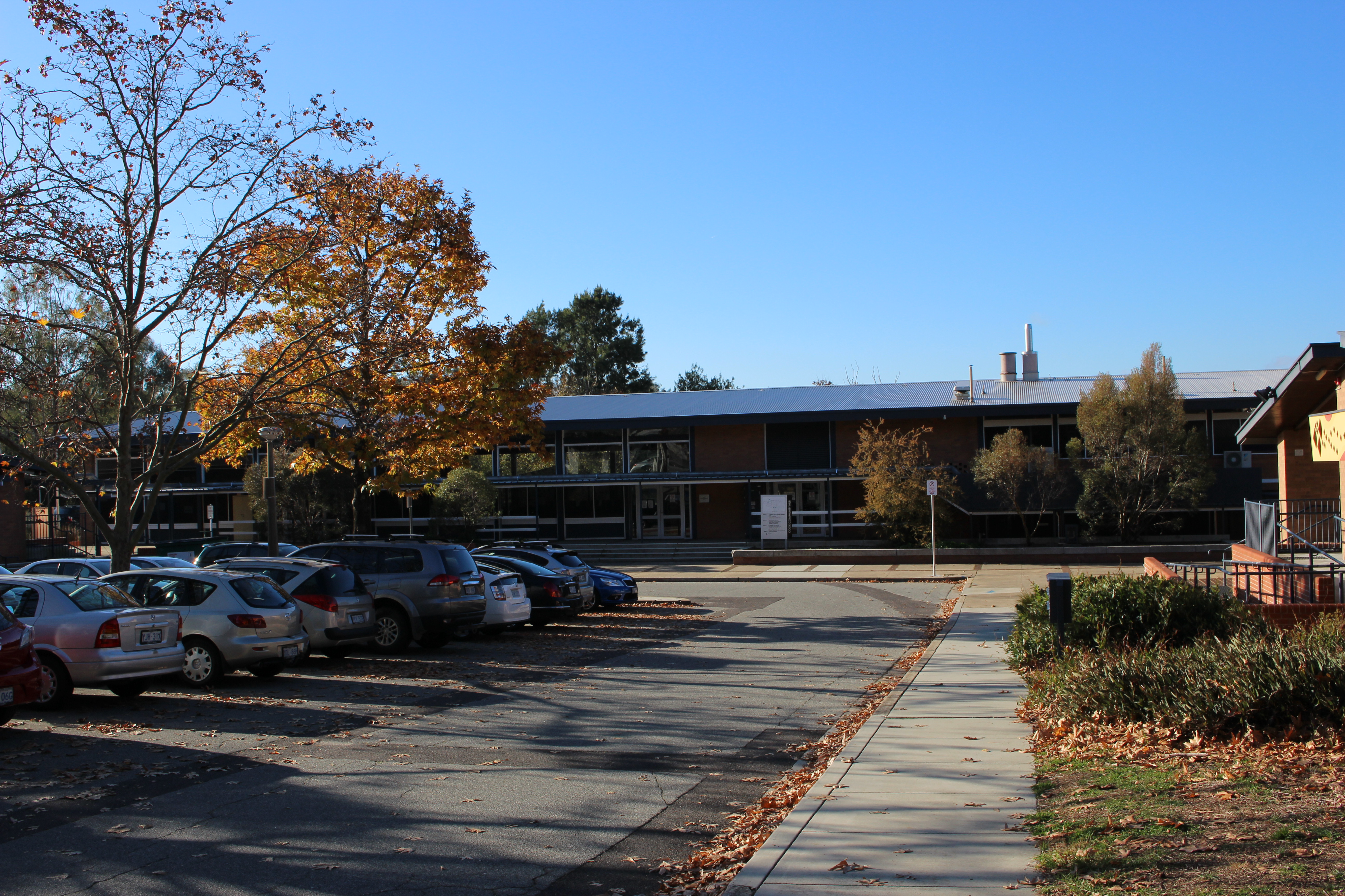
Cook ( postcode: 2614) is a suburb of the Belconnen district of Canberra, located within the Australian Capital Territory, Australia. At the , Cook had a population of 2,965 people. The suburb of Cook is named after Captain James Cook and the sixth Prime Minister of Australia Sir Joseph Cook. The streets in Cook are named after notable women from Australian history. Suburb amenities *Cook has a small shopping centre including the ''Cook Grocer'' independent supermarket, ''Little Oink'' coffee shop, ''To All My Friends'' bar, ''Jina's Hair Salon'' for men, ''Prestige Oysters'' fish monger and a public toilet. *Cook Community Hub, in place of the Cook Primary School which was a government run school for children in years K-6 until closed at the end of 2007 as part of a rationalisation of primary education across the ACT with most students moving to neighbouring schools in Aranda, Macquarie and Weetangera. *Cook Preschool *Cook school park Political representation For the ... [...More Info...] [...Related Items...] OR: [Wikipedia] [Google] [Baidu] |
Bruce, Australian Capital Territory
Bruce is a suburb of the Belconnen district of Canberra, that is located within the Australian Capital Territory, Australia. The suburb was gazetted on 6 June 1968 and named for The Viscount Bruce of Melbourne (1883–1967), the eighth Prime Minister of Australia and the first Chancellor of the Australian National University. Demographics At the , Bruce had a population of 7,520 people, an increase from 6,390 in 2011 and 3,012 in 2001. 58.1% of people were born in Australia. The next most common countries of birth were China (6.2%), India (4.9%), Nepal (3.5%), England (2.1%) and Vietnam (1.6%). 62.7% of people spoke only English at home. Other languages spoken at home included Mandarin (6.7%), Nepali (3.5%), Cantonese (2.0%) and Vietnamese (1.8%). The most common responses for religion were No Religion (44.1%) and Catholic (15.3%). 20.7% of dwellings were separate houses, 45.8% were semi-detached, row or terrace houses or townhouses and 33.4% of were units or apartments. Places ... [...More Info...] [...Related Items...] OR: [Wikipedia] [Google] [Baidu] |


