|
Chartplotter
A Chartplotter is a device used in marine navigation that integrates GPS data with an electronic navigational chart (ENC). The chartplotter displays the ENC along with the position, heading and speed of the ship, and may display additional information from radar, automatic information systems (AIS) or other sensors. As appropriate to particular marine applications, chartplotters may also display data from other sensors, such as echolocators or sonar. Technology Electronic chartplotters are by nature CPU (and GPU) intensive applications. Chartplotters need to retrieve the Navigation Signal (Galileo, GPS, GLONASS, WAAS etc.) and overlay that on a map. Map updates on dedicated hardware typically have screen refresh rates from 5 Hz to 30 Hz. Some navigation software can run on standard computers (and mobile phones, etc.) but most higher end systems are dedicated hardware. Especially when the chartplotter generates three-dimensional displays, as used for fishing, conside ... [...More Info...] [...Related Items...] OR: [Wikipedia] [Google] [Baidu] |
BVI 2009-273 (3692273152) , including a list of topics named B.VI, etc.
{{DEFAULTSORT:Bvi ...
BVI may refer to: * British Virgin Islands * Beaver County Airport, an airport near Beaver, PA with FAA LID code BVI * Birdsville Airport, IATA airport code "BVI" * Buena Vista International, a former division of The Walt Disney Company * Euronext stock market code for Bureau Veritas * Body volume index, a term used in anthropometry * Blind and/or visually impaired * Blade-vortex interaction See also * B6 (other) B6 often refers to: * Vitamin B6 B6 may also refer to: Transportation Automobiles * A generation of Audi A4, manufactured from 2001 to 2005 * A fully armoured version of the Bentley Arnage Series Two RL * A member of the Mazda B engine series ... [...More Info...] [...Related Items...] OR: [Wikipedia] [Google] [Baidu] |
Sonar
Sonar (sound navigation and ranging or sonic navigation and ranging) is a technique that uses sound propagation (usually underwater, as in submarine navigation) to navigation, navigate, measure distances (ranging), communicate with or detect objects on or under the surface of the water, such as other vessels. "Sonar" can refer to one of two types of technology: ''passive'' sonar means listening for the sound made by vessels; ''active'' sonar means emitting pulses of sounds and listening for echoes. Sonar may be used as a means of acoustic location and of measurement of the echo characteristics of "targets" in the water. Acoustic location in air was used before the introduction of radar. Sonar may also be used for robot navigation, and SODAR (an upward-looking in-air sonar) is used for atmospheric investigations. The term ''sonar'' is also used for the equipment used to generate and receive the sound. The acoustic frequencies used in sonar systems vary from very low (infrasonic ... [...More Info...] [...Related Items...] OR: [Wikipedia] [Google] [Baidu] |
WGS-84
The World Geodetic System (WGS) is a standard used in cartography, geodesy, and satellite navigation including GPS. The current version, WGS 84, defines an Earth-centered, Earth-fixed coordinate system and a geodetic datum, and also describes the associated Earth Gravitational Model (EGM) and World Magnetic Model (WMM). The standard is published and maintained by the United States National Geospatial-Intelligence Agency. Definition The coordinate origin of WGS 84 is meant to be located at the Earth's center of mass; the uncertainty is believed to be less than . The WGS 84 meridian of zero longitude is the IERS Reference Meridian,European Organisation for the Safety of Air Navigation and IfEN: WGS 84 Implementation Manual, p. 13. 1998 5.3 arc seconds or east of the Greenwich meridian at the latitude of the Royal Observatory. (This is related to the fact that the local gravity field at Greenwich doesn't point exactly through the Earth's center of mass, bu ... [...More Info...] [...Related Items...] OR: [Wikipedia] [Google] [Baidu] |
NAD-27
The North American Datum (NAD) is the horizontal datum now used to define the geodetic network in North America. A datum is a formal description of the shape of the Earth along with an "anchor" point for the coordinate system. In surveying, cartography, and land-use planning, two North American Datums are in use for making lateral or "horizontal" measurements: the North American Datum of 1927 (NAD 27) and the North American Datum of 1983 (NAD 83). Both are geodetic reference systems based on slightly different assumptions and measurements. Vertical measurements, based on distances above or below Mean High Water (MHW), are calculated using the North American Vertical Datum of 1988 (NAVD 88). NAD 83, along with NAVD 88, is set to be replaced with a new GPS- and gravimetric geoid model-based geometric reference frame and geopotential datum in 2022. First North American Datum of 1901 In 1901 the United States Coast and Geodetic Survey adopted a national horizontal da ... [...More Info...] [...Related Items...] OR: [Wikipedia] [Google] [Baidu] |
Electronic Chart Display And Information System
An Electronic Chart Display and Information System (ECDIS) is a geographic information system used for nautical navigation that complies with International Maritime Organization (IMO) regulations as an alternative to paper nautical charts. IMO refers to similar systems not meeting the regulations as Electronic Chart Systems (ECSs). An ECDIS system displays the information from Electronic Navigational Charts (ENC) and integrates position information from position, heading and speed through water reference systems and optionally other navigational sensors. Other sensors which could interface with an ECDIS are radar, Navtex, Automatic Identification Systems (AIS), and depth sounders. In recent years concerns from the industry have been raised as to the system's security especially with regards to cyber attacks and GPS spoofinattacks Application ECDIS provides continuous position and navigational safety information. The system generates audible and/or visual alarms when the ves ... [...More Info...] [...Related Items...] OR: [Wikipedia] [Google] [Baidu] |
International Maritime Organization
The International Maritime Organization (IMO, French: ''Organisation maritime internationale'') is a specialised agency of the United Nations responsible for regulating shipping. The IMO was established following agreement at a UN conference held in Geneva in 1948 and the IMO came into existence ten years later, meeting for the first time in 1959. Headquartered in London, United Kingdom, IMO currently has 175 Member States and three Associate Members. The IMO's primary purpose is to develop and maintain a comprehensive regulatory framework for shipping and its remit today includes maritime safety, environmental concerns, legal matters, technical co-operation, maritime security and the efficiency of shipping. IMO is governed by an assembly of members which meets every two years. Its finance and organization is administered by a council of 40 members elected from the assembly. The work of IMO is conducted through five committees and these are supported by technical subcommitte ... [...More Info...] [...Related Items...] OR: [Wikipedia] [Google] [Baidu] |
EPIRB
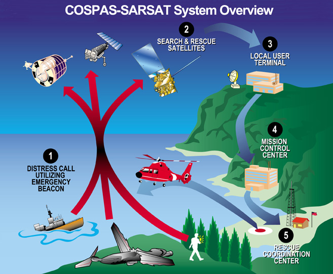
An Emergency Position-Indicating Radio Beacon (EPIRB) is a type of emergency locator beacon for commercial and recreational boats, a portable, battery-powered radio transmitter used in emergencies to locate boaters in distress and in need of immediate rescue. In the event of an emergency, such as a ship sinking or medical emergency onboard, the transmitter is activated and begins transmitting a continuous 406 MHz distress radio signal, which is used by search-and-rescue teams to quickly locate the emergency and render aid. The signal is detected by satellites operated by an international consortium of rescue services, COSPAS-SARSAT, which can detect emergency beacons anywhere on Earth transmitting on the distress frequency of 406 MHz. The satellites calculate the position or utilize the GPS coordinates of the beacon and quickly passes the information to the appropriate local first responder organization, which performs the search and rescue. As Search and Rescue approach the ... [...More Info...] [...Related Items...] OR: [Wikipedia] [Google] [Baidu] |
Wide Area Augmentation System
The Wide Area Augmentation System (WAAS) is an air navigation aid developed by the Federal Aviation Administration to augment the Global Positioning System (GPS), with the goal of improving its accuracy, integrity, and availability. Essentially, WAAS is intended to enable aircraft to rely on GPS for all phases of flight, including precision approaches to any airport within its coverage area.Federal Aviation Administration (FAAFAQ for WAAS/ref> It may be further enhanced with the Local Area Augmentation System (LAAS) also known by the preferred ICAO term Ground-Based Augmentation System (GBAS) in critical areas. WAAS uses a network of ground-based reference stations, in North America and Hawaii, to measure small variations in the GPS satellites' signals in the western hemisphere. Measurements from the reference stations are routed to master stations, which queue the received Deviation Correction (DC) and send the correction messages to geostationary WAAS satellites in a timely ... [...More Info...] [...Related Items...] OR: [Wikipedia] [Google] [Baidu] |
Navigation
Navigation is a field of study that focuses on the process of monitoring and controlling the movement of a craft or vehicle from one place to another.Bowditch, 2003:799. The field of navigation includes four general categories: land navigation, marine navigation, aeronautic navigation, and space navigation. It is also the term of art used for the specialized knowledge used by navigators to perform navigation tasks. All navigational techniques involve locating the navigator's position compared to known locations or patterns. Navigation, in a broader sense, can refer to any skill or study that involves the determination of position and direction. In this sense, navigation includes orienteering and pedestrian navigation. History In the European medieval period, navigation was considered part of the set of '' seven mechanical arts'', none of which were used for long voyages across open ocean. Polynesian navigation is probably the earliest form of open-ocean navigation; it was ... [...More Info...] [...Related Items...] OR: [Wikipedia] [Google] [Baidu] |
GLONASS
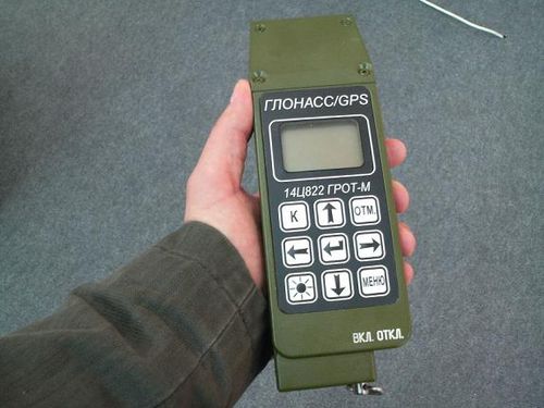
GLONASS (russian: ГЛОНАСС, label=none, ; rus, links=no, Глобальная навигационная спутниковая система, r=Global'naya Navigatsionnaya Sputnikovaya Sistema, t=Global Navigation Satellite System) is a Russian satellite navigation system operating as part of a radionavigation-satellite service. It provides an alternative to Global Positioning System (GPS) and is the second navigational system in operation with global coverage and of comparable precision. Satellite navigation devices supporting both GPS and GLONASS have more satellites available, meaning positions can be fixed more quickly and accurately, especially in built-up areas where buildings may obscure the view to some satellites. GLONASS supplementation of GPS systems also improves positioning in high latitudes (north or south). Development of GLONASS began in the Soviet Union in 1976. Beginning on 12 October 1982, numerous rocket launches added satellites to the system, unti ... [...More Info...] [...Related Items...] OR: [Wikipedia] [Google] [Baidu] |
.jpg)


