|
Zelyony Gorod
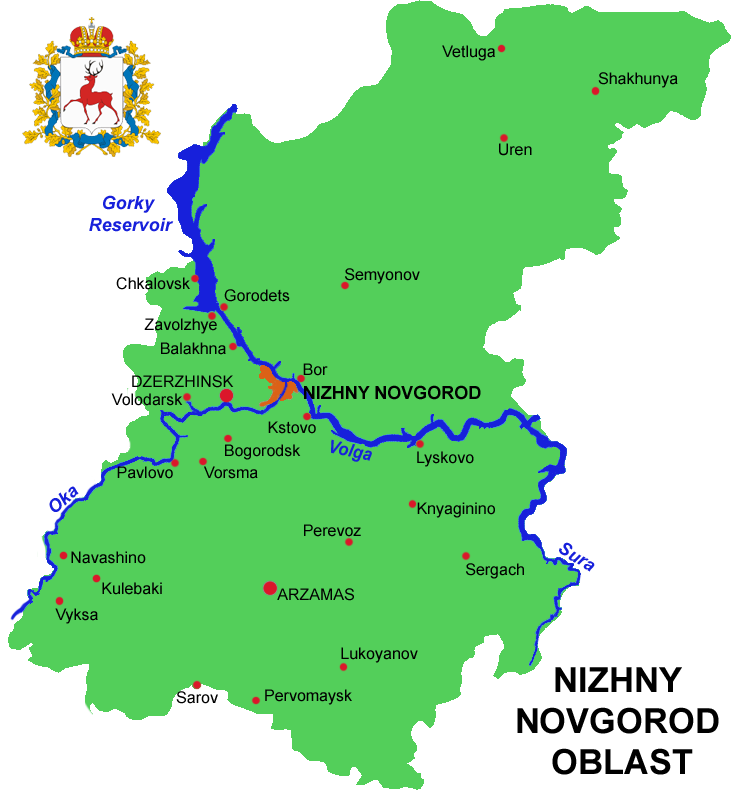
Zelyony Gorod (russian: Зелёный Го́род, lit. ''green city'') is an urban locality (a resort settlement under the administrative jurisdiction of the city of oblast significance of Nizhny Novgorod) in Nizhny Novgorod Oblast, Russia, located in a forested area to the southeast of Nizhny Novgorod and surrounded by the territory of Kstovsky District. Population: The forested area around the settlement is a surviving part of a much larger forest area that existed here centuries ago. Geographically, it is located Nizhny Novgorod and Kstovo, and is bounded roughly by Highway M-7 and Pavlovo- Royka- Zeletsino railway from the north and the Kudma River The Kudma (russian: Кудьма, ''Kud'ma'') is a river in Nizhny Novgorod Oblast of Russia, a right tributary of the Volga. It is long, and has a drainage basin of . [...More Info...] [...Related Items...] OR: [Wikipedia] [Google] [Baidu] |
Nizhny Novgorod Oblast
Nizhny Novgorod Oblast (russian: link=no, Нижегородская область, ''Nizhegorodskaya oblast''), is a federal subjects of Russia, federal subject of Russia (an oblast). Its administrative center is the types of inhabited localities in Russia, city of Nizhny Novgorod. It has a population of 3,310,597 as of the Russian Census (2010), 2010 Census. From 1932 to 1990 it was known as Gorky Oblast. The oblast is crossed by the Volga River. Apart from Nizhny Novgorod's metropolitan area (including Dzerzhinsk, Russia, Dzerzhinsk, Bor, Nizhny Novgorod Oblast, Bor and Kstovo) the biggest city is Arzamas. Near the town of Sarov there is the Serafimo-Diveyevsky Monastery, one of the largest convents in Russia, established by Seraphim of Sarov, Saint Seraphim of Sarov. The Makaryev Monastery opposite of the town of Lyskovo, Nizhny Novgorod Oblast, Lyskovo used to be the location of the largest fair in Eastern Europe. Other historic towns include Gorodets, Nizhny Novgorod Oblast ... [...More Info...] [...Related Items...] OR: [Wikipedia] [Google] [Baidu] |
Types Of Inhabited Localities In Russia
The classification system of inhabited localities in Russia and some other post-Soviet states has certain peculiarities compared with those in other countries. Classes During the Soviet time, each of the republics of the Soviet Union, including the Russian SFSR, had its own legislative documents dealing with classification of inhabited localities. After the dissolution of the Soviet Union, the task of developing and maintaining such classification in Russia was delegated to the federal subjects.Articles 71 and 72 of the Constitution of Russia do not name issues of the administrative and territorial structure among the tasks handled on the federal level or jointly with the governments of the federal subjects. As such, all federal subjects pass their own laws establishing the system of the administrative-territorial divisions on their territories. While currently there are certain peculiarities to classifications used in many federal subjects, they are all still largely ba ... [...More Info...] [...Related Items...] OR: [Wikipedia] [Google] [Baidu] |
Urban-type Settlement
Urban-type settlementrussian: посёлок городско́го ти́па, translit=posyolok gorodskogo tipa, abbreviated: russian: п.г.т., translit=p.g.t.; ua, селище міського типу, translit=selyshche mis'koho typu, abbreviated: uk, с.м.т., translit=s.m.t.; be, пасёлак гарадскога тыпу, translit=pasiolak haradskoha typu; pl, osiedle typu miejskiego; bg, селище от градски тип, translit=selishte ot gradski tip; ro, așezare de tip orășenesc. is an official designation for a semi-urban settlement (previously called a "town A town is a human settlement. Towns are generally larger than villages and smaller than cities, though the criteria to distinguish between them vary considerably in different parts of the world. Origin and use The word "town" shares an ori ..."), used in several Eastern European countries. The term was historically used in Bulgaria, Poland, and the Soviet Union, and remains in use ... [...More Info...] [...Related Items...] OR: [Wikipedia] [Google] [Baidu] |
City Of Federal Subject Significance
City of federal subject significance is an administrative division of a federal subject of Russia which is equal in status to a district but is organized around a large city; occasionally with surrounding rural territories. Description According to the 1993 Constitution of Russia, the administrative-territorial structure of the federal subjects is not identified as the responsibility of the federal government or as the joint responsibility of the federal government and the federal subjects."Энциклопедический словарь конституционного права". Статья "Административно-территориальное устройство". Сост. А. А. Избранов. — Мн.: Изд. В.М. Суров, 2001. This state of the matters is traditionally interpreted by the governments of the federal subjects as a sign that the matters of the administrative-territorial divisions are the sole responsibility of the fede ... [...More Info...] [...Related Items...] OR: [Wikipedia] [Google] [Baidu] |
Nizhny Novgorod
Nizhny Novgorod ( ; rus, links=no, Нижний Новгород, a=Ru-Nizhny Novgorod.ogg, p=ˈnʲiʐnʲɪj ˈnovɡərət ), colloquially shortened to Nizhny, from the 13th to the 17th century Novgorod of the Lower Land, formerly known as Gorky (, ; 1932–1990), is the administrative centre of Nizhny Novgorod Oblast and the Volga Federal District. The city is located at the confluence of the Oka and the Volga rivers in Central Russia, with a population of over 1.2 million residents, up to roughly 1.7 million residents in the urban agglomeration. Nizhny Novgorod is the sixth-largest city in Russia, the second-most populous city on the Volga, as well as the Volga Federal District. It is an important economic, transportation, scientific, educational and cultural center in Russia and the vast Volga-Vyatka economic region, and is the main center of river tourism in Russia. In the historic part of the city there are many universities, theaters, museums and churches. The city w ... [...More Info...] [...Related Items...] OR: [Wikipedia] [Google] [Baidu] |
Russia
Russia (, , ), or the Russian Federation, is a List of transcontinental countries, transcontinental country spanning Eastern Europe and North Asia, Northern Asia. It is the List of countries and dependencies by area, largest country in the world, with its internationally recognised territory covering , and encompassing one-eighth of Earth's inhabitable landmass. Russia extends across Time in Russia, eleven time zones and shares Borders of Russia, land boundaries with fourteen countries, more than List of countries and territories by land borders, any other country but China. It is the List of countries and dependencies by population, world's ninth-most populous country and List of European countries by population, Europe's most populous country, with a population of 146 million people. The country's capital and List of cities and towns in Russia by population, largest city is Moscow, the List of European cities by population within city limits, largest city entirely within E ... [...More Info...] [...Related Items...] OR: [Wikipedia] [Google] [Baidu] |
Kstovsky District
Kstovsky District (russian: Ксто́вский райо́н) is an administrative district (raion), one of the forty in Nizhny Novgorod Oblast, Russia.Order #3-od Municipally, it is incorporated as Kstovsky Municipal District.Resolution #670 It is located in the center of the oblast. The area of the district is . Its administrative center is the town of Kstovo. Population: 112,823 ( 2010 Census); The population of Kstovo accounts for 59.1% of the district's total population. Geography Kstovsky District is located along the southern shore of the Volga River. The westernmost part of the district is adjacent to the city of Nizhny Novgorod. It is gradually becoming more suburban, its housing developments and shopping centers closely linked to the life of the city. The east of the district is more rural, with potato, root crops, and grain fields and cattle pastures alternating with forests and dacha areas. History The district was established in 1929 and given its present name in 19 ... [...More Info...] [...Related Items...] OR: [Wikipedia] [Google] [Baidu] |
Kstovo
Kstovo (russian: Ксто́во) is a town and the administrative center of Kstovsky District in Nizhny Novgorod Oblast, Russia, located on the right bank of the Volga River, southeast of Nizhny Novgorod, the administrative center of the oblast. Population: Etymology The place name is said to have originated from the Mordvin ''ksty'', meaning "strawberry". History The village of Kstovo was mentioned as early as the 14th century. With the construction of Novogorkovsky Oil Refinery, which started operations on August 18, 1958,) a new settlement was built a few kilometers to the northwest of the old village of Kstovo, on the high ground between the Volga and the Kudma Rivers. Since then, the western part of the town centered on the original village of Kstovo, and, still quite rural in character, has been commonly referred to as the Old Kstovo (''Staroye Kstovo''), while the newer eastern part, built in the 1950s and still expanding, is known as the New Kstovo (''Novoye Ks ... [...More Info...] [...Related Items...] OR: [Wikipedia] [Google] [Baidu] |
M7 Motorway (Russia)
The Russian Route M7 (also known as the ''Volga Highway'') is a major trunk road running from Moscow through Vladimir and Nizhny Novgorod to Kazan in Tatarstan and Ufa in Bashkortostan. It generally follows the route of the historic Vladimirka road and, to a large extent, forms part of the European route E22. The section from Yelabuga to Ufa is also part of European route E017. Major junctions Route : 0 km — Moscow Ring Road : 35 km — Elektrostal and Noginsk : 65 km — Malaya Dubna near Orekhovo-Zuyevo : ''Vladimir Oblast'' : 81 km — Pokrov : 130 km — Lakinsk : 158 km — Yuryevets : 162 km — Vladimir : 225 km — a branch to Kovrov : 273 km — Vyazniki : 313 km — Gorokhovets : ''Nizhny Novgorod Oblast'' : 397 km — crossing the Oka River in Nizhny Novgorod (over the Myza Bridge) : 430 km — Kstovo : 463 km — Rabotki : 491 km — Lyskovo : 544 km — Vorotynets : '' Chuvash Republic'' : 634 km — crossing the Vyatka Highway in Cheboksary : 679 km � ... [...More Info...] [...Related Items...] OR: [Wikipedia] [Google] [Baidu] |
Pavlovo, Nizhny Novgorod Oblast
Pavlovo (russian: Павлово) is the name of several inhabited localities in Russia. Arkhangelsk Oblast As of 2010, one rural locality in Arkhangelsk Oblast bears this name: * Pavlovo, Arkhangelsk Oblast, a village under the administrative jurisdiction of the town of oblast significance of Novodvinsk Ivanovo Oblast As of 2010, one rural locality in Ivanovo Oblast bears this name: * Pavlovo, Ivanovo Oblast, a village in Yuryevetsky District Kaliningrad Oblast As of 2010, one rural locality in Kaliningrad Oblast bears this name: * Pavlovo, Kaliningrad Oblast, a settlement in Novostroyevsky Rural Okrug of Ozyorsky District Kaluga Oblast As of 2010, three rural localities in Kaluga Oblast bear this name: * Pavlovo, Borovsky District, Kaluga Oblast, a village in Borovsky District * Pavlovo, Kozelsky District, Kaluga Oblast, a village in Kozelsky District * Pavlovo, Mosalsky District, Kaluga Oblast, a village in Mosalsky District Kirov Oblast As of 2010, two rural localities i ... [...More Info...] [...Related Items...] OR: [Wikipedia] [Google] [Baidu] |


