|
Yorba Linda Fault .
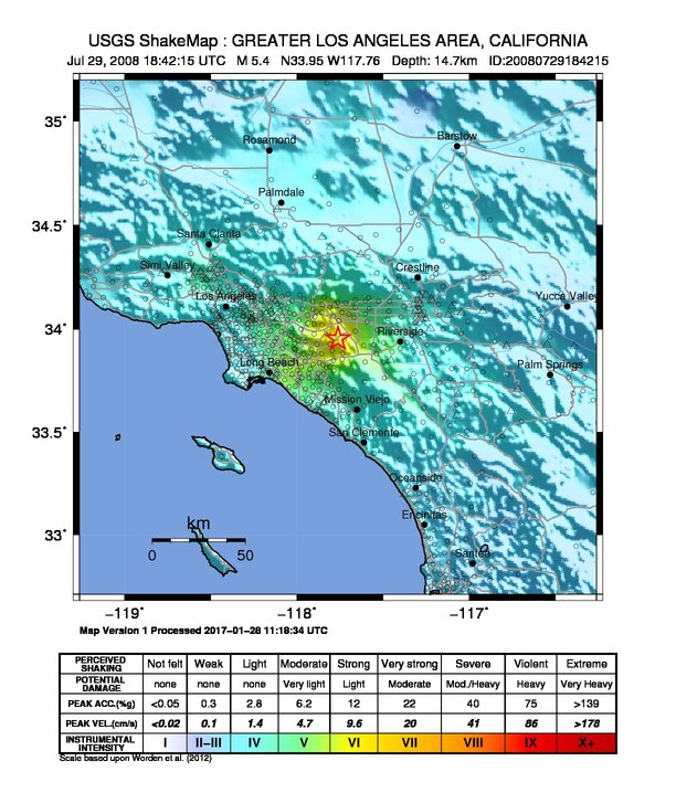
The fault was discovered in the late 1990s and is known to have caused the 5.5 2008 Chino Hills earthquake. The fault is believed to produce a 6.0 earthquake at most.
Seismic faults of California
Geology of Orange County, California
Chino Hills (California)
Chino Hills, California
Yorba Linda, California
{{OrangeCountyCA-geo-stub ...
The Yorba Linda Fault or Yorba Linda Trend is a fault system that extends from northeast Yorba Linda, California to the southeastern portion of the Chino Hills and Chino Hills (city), in San Bernardino County, California San Bernardino County (), officially the County of San Bernardino, is a County (United States), county located in the Southern California, southern portion of the U.S. state of California, and is located within the Inland Empire area. As of the ... [...More Info...] [...Related Items...] OR: [Wikipedia] [Google] [Baidu] |
Yorba Linda, California
Yorba Linda is a suburban city in northeastern Orange County, California, United States, approximately southeast of Downtown Los Angeles. It is part of the Los Angeles metropolitan area, and had a population of 68,336 at the 2020 census. Yorba Linda is known for its connection to Richard Nixon, the 37th president of the United States. His birthplace is a National Historic Landmark, and his presidential library and museum are also located in the city. Etymology The name Yorba Linda is made up of two parts: Yorba, after Don Bernardo Yorba, a Californio ranchero who historically owned the area, and Linda, Spanish for beautiful. The name was created 1908 by the Janss Investment Company. History Pre-colonization The area is the home of the Tongva, Luiseño, and Juaneño tribal nations, who were there "as early as 4,000 years ago." The Tongva defined their world as Tovaangar, a nation which "extended from Palos Verdes to San Bernardino, from Saddleback Mountain to the San Fe ... [...More Info...] [...Related Items...] OR: [Wikipedia] [Google] [Baidu] |
Chino Hills
The Chino Hills are a mountain range on the border of Orange, Los Angeles, and San Bernardino counties, California, with a small portion in Riverside County. The Chino Hills State Park preserves open space and habitat in them. Geography The Chino Hills are separated from the Santa Ana Mountains to the south by the Santa Ana River (Santa Ana Canyon). On the northwest, Brea Canyon separates the Chino Hills from the Puente Hills.''Santa Ana, California,'' 30x60 Minute Topographic Quadrangle, USGS, 1983 To the north of the Puente Hills and San Jose Creek lie the San Jose Hills. The only paved road crossing the Chino Hills is Carbon Canyon Road (State Route 142). Flora The Chino Hills are in the California chaparral and woodlands ecoregion of the California Floristic Province. The California native plants here are in the chaparral and oak woodland plant communities, with remnant stands of native grasses of California. Chino Hills earthquake On July 29, 2008, a magnitude 5. ... [...More Info...] [...Related Items...] OR: [Wikipedia] [Google] [Baidu] |
Chino Hills, California
Chino Hills (''Chino'', Spanish for "Curly") is a city located in the southwestern corner of San Bernardino County, California, United States. The city borders Los Angeles County on its northwest side, Orange County to its south and southwest, and Riverside County to its southeast. History Indigenous Prior to the colonization of the area by the Spanish Empire in the late 18th century, the Tongva village of Wapijanga was the major point of influence in what would become referred to as Chino Hills. The village was an important point of connection between the Tongva and Serrano. Spanish and Mexican eras After the Spanish founded Mission San Gabriel in 1771, the Chino Hills region was used extensively for grazing by mission cattle. During the Mexican Republic era, the hills were used as spillover grazing from such surrounding Mexican ranchos as Santa Ana del Chino and Rancho La Sierra (Yorba). Early American era After Mexico ceded California to the United States it was, and ... [...More Info...] [...Related Items...] OR: [Wikipedia] [Google] [Baidu] |
San Bernardino County, California
San Bernardino County (), officially the County of San Bernardino, is a County (United States), county located in the Southern California, southern portion of the U.S. state of California, and is located within the Inland Empire area. As of the 2020 United States Census, 2020 U.S. Census, the population was 2,181,654, making it the fifth-most populous county in California and the List of the most populous counties in the United States, 14th-most populous in the United States. The county seat is San Bernardino, California, San Bernardino. While included within the Greater Los Angeles area, San Bernardino County is included in the Riverside, California, Riverside–San Bernardino, California, San Bernardino–Ontario, California, Ontario metropolitan statistical area, as well as the Los Angeles–Long Beach, California, Long Beach Greater Los Angeles Area, combined statistical area. With an area of , San Bernardino County is the List of the largest counties in the United States by ... [...More Info...] [...Related Items...] OR: [Wikipedia] [Google] [Baidu] |
2008 Chino Hills Earthquake
The 2008 Chino Hills earthquake occurred at 11:42:15 am PDT (18:42:15 UTC) on July 29 in Southern California. The epicenter of the magnitude 5.4 earthquake was in Chino Hills, c. east-southeast of downtown Los Angeles. Though there were no deaths, eight people were injured, and it caused considerable damage in numerous structures throughout the area and caused some amusement park facilities to shut down their rides. The earthquake led to increased discussion regarding the possibility of a stronger earthquake in the future. Earthquake The Chino Hills earthquake was caused by oblique-slip faulting, with components of both thrust and sinistral strike-slip displacement. Preliminary reports cited the Whittier fault as the active cause, but the quake was later determined to have been generated by the " Yorba Linda trend," as identified by Caltech seismologist Egill Hauksson. Its epicenter was within of Chino Hills and its hypocenter was c. deep. Initial estimations of t ... [...More Info...] [...Related Items...] OR: [Wikipedia] [Google] [Baidu] |
Earthquake
An earthquake (also known as a quake, tremor or temblor) is the shaking of the surface of the Earth resulting from a sudden release of energy in the Earth's lithosphere that creates seismic waves. Earthquakes can range in intensity, from those that are so weak that they cannot be felt, to those violent enough to propel objects and people into the air, damage critical infrastructure, and wreak destruction across entire cities. The seismic activity of an area is the frequency, type, and size of earthquakes experienced over a particular time period. The seismicity at a particular location in the Earth is the average rate of seismic energy release per unit volume. The word ''tremor'' is also used for Episodic tremor and slip, non-earthquake seismic rumbling. At the Earth's surface, earthquakes manifest themselves by shaking and displacing or disrupting the ground. When the epicenter of a large earthquake is located offshore, the seabed may be displaced sufficiently to cause ... [...More Info...] [...Related Items...] OR: [Wikipedia] [Google] [Baidu] |
Seismic Faults Of California
Seismology (; from Ancient Greek σεισμός (''seismós'') meaning "earthquake" and -λογία (''-logía'') meaning "study of") is the scientific study of earthquakes and the propagation of elastic waves through the Earth or through other planet-like bodies. It also includes studies of earthquake environmental effects such as tsunamis as well as diverse seismic sources such as volcanic, tectonic, glacial, fluvial, oceanic, atmospheric, and artificial processes such as explosions. A related field that uses geology to infer information regarding past earthquakes is paleoseismology. A recording of Earth motion as a function of time is called a seismogram. A seismologist is a scientist who does research in seismology. History Scholarly interest in earthquakes can be traced back to antiquity. Early speculations on the natural causes of earthquakes were included in the writings of Thales of Miletus (c. 585 BCE), Anaximenes of Miletus (c. 550 BCE), Aristotle (c. 340 BCE), and Zhan ... [...More Info...] [...Related Items...] OR: [Wikipedia] [Google] [Baidu] |
Geology Of Orange County, California
Geology () is a branch of natural science concerned with Earth and other astronomical objects, the features or rocks of which it is composed, and the processes by which they change over time. Modern geology significantly overlaps all other Earth sciences, including hydrology, and so is treated as one major aspect of integrated Earth system science and planetary science. Geology describes the structure of the Earth on and beneath its surface, and the processes that have shaped that structure. It also provides tools to determine the relative and absolute ages of rocks found in a given location, and also to describe the histories of those rocks. By combining these tools, geologists are able to chronicle the geological history of the Earth as a whole, and also to demonstrate the age of the Earth. Geology provides the primary evidence for plate tectonics, the evolutionary history of life, and the Earth's past climates. Geologists broadly study the properties and processes of ... [...More Info...] [...Related Items...] OR: [Wikipedia] [Google] [Baidu] |
Chino Hills (California)
The Chino Hills are a mountain range on the border of Orange, Los Angeles, and San Bernardino counties, California, with a small portion in Riverside County. The Chino Hills State Park preserves open space and habitat in them. Geography The Chino Hills are separated from the Santa Ana Mountains to the south by the Santa Ana River (Santa Ana Canyon). On the northwest, Brea Canyon separates the Chino Hills from the Puente Hills.''Santa Ana, California,'' 30x60 Minute Topographic Quadrangle, USGS, 1983 To the north of the Puente Hills and San Jose Creek lie the San Jose Hills. The only paved road crossing the Chino Hills is Carbon Canyon Road (State Route 142). Flora The Chino Hills are in the California chaparral and woodlands ecoregion of the California Floristic Province. The California native plants here are in the chaparral and oak woodland plant communities, with remnant stands of native grasses of California. Chino Hills earthquake On July 29, 2008, a magnitude 5.4 ear ... [...More Info...] [...Related Items...] OR: [Wikipedia] [Google] [Baidu] |


.jpg)


