|
Yellowcraigs
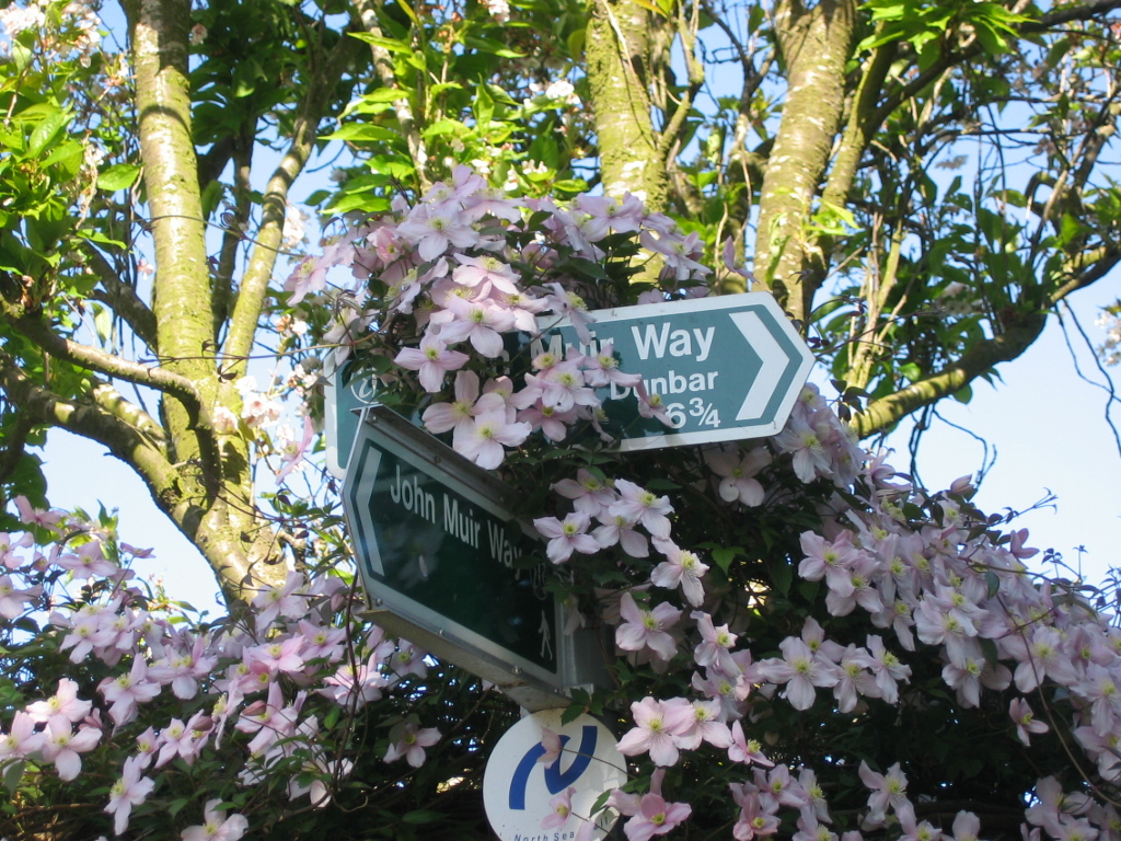
Yellowcraig, also known as Broad Sands Beach, is a coastal area of forest, beach and grassland in East Lothian, south-east Scotland. Yellowcraig is partly within the Firth of Forth Site of Special Scientific Interest (SSSI). It is bordered to the north by the Firth of Forth, to the south by the village of Dirleton and Dirleton Castle, to the east by the North Berwick West Links golf course, and to the west by the Archerfield Estate and Links golf courses. Access to Yellowcraig is by the A198 coastal route through Dirleton. A visitor car park lies south of the beach. The area includes information displays, a barbecue area and a Treasure Island themed adventure play park. WCs and showers are located at the car park. There is also a wheelchair accessible path and ramp giving a view over the beach. Yellowcraig is on the John Muir Way, a long distance footpath between Fisherrow, Musselburgh and Dunglass, named in honour of the conservationist John Muir, who was born in Dunba ... [...More Info...] [...Related Items...] OR: [Wikipedia] [Google] [Baidu] |
Fidra
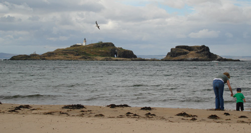
Fidra (archaically Fidrey or Fetheray) is a currently uninhabited island in the Firth of Forth, northwest of North Berwick, on the east coast of Scotland. The island is an RSPB Scotland nature reserve. Geography Like the other islands near North Berwick, Fidra is the result of volcanic activity around 335 million years ago. Fidra consists of three sections; a hill at one end with the lighthouse on it; a low-lying section in the middle, effectively an isthmus; and a rocky stack at the other end. History The island's name is believed to be Old Norse in origin, referring to the large number of bird feathers found there. Like the nearby Bass Rock, it has a substantial seabird population, and is now an RSPB reserve. The village of Gullane lies to the south-west, and the nature reserve of Yellowcraig and village of Dirleton, to which parish Fidra belongs,Martine, John (1890) ''Fourteen Parishes of the County of Haddington'', Edinburgh, p.50-51 are to the south. Remotely operated ... [...More Info...] [...Related Items...] OR: [Wikipedia] [Google] [Baidu] |
Fidra As Seen From Yellowcraigs Beach
Fidra (archaically Fidrey or Fetheray) is a currently uninhabited island in the Firth of Forth, northwest of North Berwick, on the east coast of Scotland. The island is an RSPB Scotland nature reserve. Geography Like the other islands near North Berwick, Fidra is the result of volcanic activity around 335 million years ago. Fidra consists of three sections; a hill at one end with the lighthouse on it; a low-lying section in the middle, effectively an isthmus; and a rocky stack at the other end. History The island's name is believed to be Old Norse in origin, referring to the large number of bird feathers found there. Like the nearby Bass Rock, it has a substantial seabird population, and is now an RSPB reserve. The village of Gullane lies to the south-west, and the nature reserve of Yellowcraig and village of Dirleton, to which parish Fidra belongs,Martine, John (1890) ''Fourteen Parishes of the County of Haddington'', Edinburgh, p.50-51 are to the south. Remotely operated ... [...More Info...] [...Related Items...] OR: [Wikipedia] [Google] [Baidu] |
North Berwick West Links
One of two golf courses within North Berwick, the West Links is by far the more renowned. It regularly holds various championships and is used as a qualifying venue when The Open Championship is held at Muirfield (most recently 2013). It was opened in 1832 and occupies a place at the centre of golfing history. History The area which is home to the course today - a strip of land adjacent to the beach and extending westward over 2 miles from the edge of the town centre to the nature reserve at Yellowcraigs - has been used for golf for at least 400 years, although early participants were not welcomed by local landowners or authorities. The course was officially opened in 1832 with 6 holes, necessitating competitions to be played over 3 rounds. After a period of expansion which began in 1868, the course featured 18 holes by 1877 and was extended to a "full length" of 6095 yards in 1895. The last major alteration to the course was masterminded by Ben Sayers in 1932, since which time t ... [...More Info...] [...Related Items...] OR: [Wikipedia] [Google] [Baidu] |
East Lothian
East Lothian (; sco, East Lowden; gd, Lodainn an Ear) is one of the 32 council areas of Scotland, as well as a historic county, registration county and lieutenancy area. The county was called Haddingtonshire until 1921. In 1975, the historic county was incorporated for local government purposes into Lothian Region as East Lothian District, with some slight alterations of its boundaries. The Local Government etc. (Scotland) Act 1994 later created East Lothian as one of 32 modern council areas. East Lothian lies south of the Firth of Forth in the eastern central Lowlands of Scotland. It borders Edinburgh to the west, Midlothian to the south-west and the Scottish Borders to the south. Its administrative centre and former county town is Haddington while the largest town is Musselburgh. Haddingtonshire has ancient origins and is named in a charter of 1139 as ''Hadintunschira'' and in another of 1141 as ''Hadintunshire''. Three of the county's towns were designated as roy ... [...More Info...] [...Related Items...] OR: [Wikipedia] [Google] [Baidu] |
Firth Of Forth
The Firth of Forth () is the estuary, or firth, of several Scottish rivers including the River Forth. It meets the North Sea with Fife on the north coast and Lothian on the south. Name ''Firth'' is a cognate of ''fjord'', a Norse word meaning a narrow inlet. ''Forth'' stems from the name of the river; this is ''*Vo-rit-ia'' (slow running) in Proto-Celtic, yielding '' Foirthe'' in Old Gaelic and '' Gweryd'' in Welsh. It was known as ''Bodotria'' in Roman times. In the Norse sagas it was known as the ''Myrkvifiörd''. An early Welsh name is ''Merin Iodeo'', or the "Sea of Iudeu". Geography and economy Geologically, the Firth of Forth is a fjord, formed by the Forth Glacier in the last glacial period. The drainage basin for the Firth of Forth covers a wide geographic area including places as far from the shore as Ben Lomond, Cumbernauld, Harthill, Penicuik and the edges of Gleneagles Golf Course. Many towns line the shores, as well as the petrochemical complexes at Gr ... [...More Info...] [...Related Items...] OR: [Wikipedia] [Google] [Baidu] |
Dirleton
Dirleton is a village and civil parish in East Lothian, Scotland approximately east of Edinburgh on the A198. It contains . Dirleton lies between North Berwick (east), Gullane (west), Fenton Barns (south) and the Yellowcraigs nature reserve, Archerfield Estate and the Firth of Forth (north). Gullane parish was joined to Dirleton parish in 1612 by an Act of Parliament because "Golyn (as it was anciently spelt) is ane decaying toun, and Dirleton is ane thriven place." Locale Dirleton has two hotels, The Castle Inn which looks on to the village green and The Open Arms Hotel. Other visitor attractions today include the Dirleton Gallery, now closed for business, Archerfield Links recently built with two 18-hole golf courses and hotel. The church (presumably built soon after the move of the parish in 1612) and manse (1708) of Dirleton stand immediately to the north of the village in a beautiful situation. The church has extensive Victorian renovations (1836 including the ornate to ... [...More Info...] [...Related Items...] OR: [Wikipedia] [Google] [Baidu] |
Treasure Island
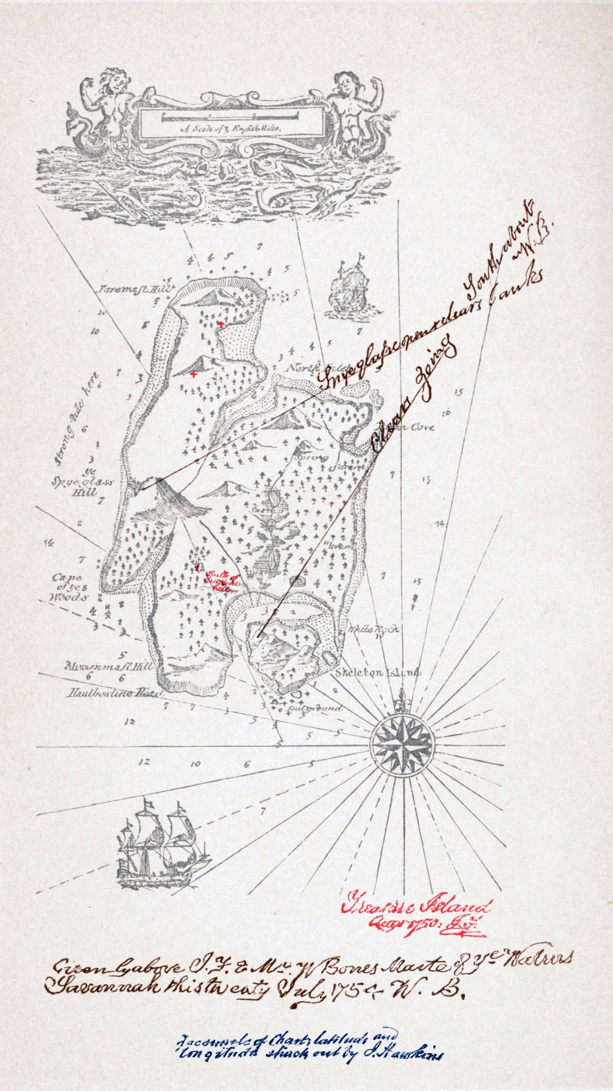
''Treasure Island'' (originally titled ''The Sea Cook: A Story for Boys''Hammond, J. R. 1984. "Treasure Island." In ''A Robert Louis Stevenson Companion'', Palgrave Macmillan Literary Companions. London: Palgrave Macmillan. .) is an adventure novel by Scotland, Scottish author Robert Louis Stevenson, telling a story of "piracy, buccaneers and Buried treasure, buried gold". It is considered a Bildungsroman, coming-of-age story and is noted for its atmosphere, characters, and action. The novel was originally serialised from 1881 to 1882 in the children's magazine ''Young Folks (magazine), Young Folks'', under the title ''Treasure Island or the Mutiny of the Hispaniola'', credited to the pseudonym "Captain George North". It was first published as a book on 14 November 1883 by Cassell & Co. It has since become one of the most often dramatized and adapted of all novels, in numerous media. Since its publication, ''Treasure Island'' has had significant influence on Pirates in the arts ... [...More Info...] [...Related Items...] OR: [Wikipedia] [Google] [Baidu] |
North Berwick
North Berwick (; gd, Bearaig a Tuath) is a seaside town A seaside resort is a town, village, or hotel that serves as a vacation resort and is located on a coast. Sometimes the concept includes an aspect of official accreditation based on the satisfaction of certain requirements, such as in the German ' ... and former royal burgh in East Lothian, Scotland. It is situated on the south shore of the Firth of Forth, approximately east-northeast of Edinburgh. North Berwick became a fashionable holiday resort in the nineteenth century because of its two sandy bays, the East (or Milsey) Bay and the West Bay, and continues to attract holidaymakers. Golf courses at the ends of each bay are open to visitors. Name The name Berwick means "barley farmstead" (''bere'' in Old English means "barley" and ''wic'' means "farmstead"). Alternatively, like other place names in Scotland ending in 'wick', this word means 'bay' (Old Norse: vík). The word North was applied to distinguish this Berw ... [...More Info...] [...Related Items...] OR: [Wikipedia] [Google] [Baidu] |
North Sea Trail
The North Sea Trail is a transnational long-distance hiking trail along the coast of the North Sea. The route passes through seven countries and 26 partner areas. The aim of the project is to promote sustainable tourism and to keep alive the common cultural heritage of the North Sea countries. The trail has a theoretical total length of about 4900 km, but so far only about 3700 km have been developed. The EU-funded North Sea Trail project involves Sweden, Norway, Scotland, England, the Netherlands, Denmark and Germany. Route The trail starts in the north of Great Britain in Scotland and stretches along the entire east coast. The trail continues along the Dutch and German coasts to Denmark. Denmark is rounded out'Literature , Title=The North Sea Trail , Collectible=Toppenafdanmark , Online=https://www.visithirtshals.dk/ln-int/north-sea-trail-gdk641071 , Retrieval=2018-08-19 and the path on the west coast of Sweden continued from Kattegat to the Skagerrak. The trail ... [...More Info...] [...Related Items...] OR: [Wikipedia] [Google] [Baidu] |
North Sea
The North Sea lies between Great Britain, Norway, Denmark, Germany, the Netherlands and Belgium. An epeiric sea on the European continental shelf, it connects to the Atlantic Ocean through the English Channel in the south and the Norwegian Sea in the north. It is more than long and wide, covering . It hosts key north European shipping lanes and is a major fishery. The coast is a popular destination for recreation and tourism in bordering countries, and a rich source of energy resources, including wind and wave power. The North Sea has featured prominently in geopolitical and military affairs, particularly in Northern Europe, from the Middle Ages to the modern era. It was also important globally through the power northern Europeans projected worldwide during much of the Middle Ages and into the modern era. The North Sea was the centre of the Vikings' rise. The Hanseatic League, the Dutch Republic, and the British each sought to gain command of the North Sea and access t ... [...More Info...] [...Related Items...] OR: [Wikipedia] [Google] [Baidu] |
Robert Louis Stevenson
Robert Louis Stevenson (born Robert Lewis Balfour Stevenson; 13 November 1850 – 3 December 1894) was a Scottish novelist, essayist, poet and travel writer. He is best known for works such as ''Treasure Island'', ''Strange Case of Dr Jekyll and Mr Hyde'', '' Kidnapped'' and ''A Child's Garden of Verses''. Born and educated in Edinburgh, Stevenson suffered from serious bronchial trouble for much of his life, but continued to write prolifically and travel widely in defiance of his poor health. As a young man, he mixed in London literary circles, receiving encouragement from Andrew Lang, Edmund Gosse, Leslie Stephen and W. E. Henley, the last of whom may have provided the model for Long John Silver in ''Treasure Island''. In 1890, he settled in Samoa where, alarmed at increasing European and American influence in the South Sea islands, his writing turned away from romance and adventure fiction toward a darker realism. He died of a stroke in his island home in 1894 at ... [...More Info...] [...Related Items...] OR: [Wikipedia] [Google] [Baidu] |


.jpg)


