|
Yaremche Municipality
Yaremche Municipality was an administrative subdivision of the Ivano-Frankivsk Oblast. Population: . The municipality was created on December 30, 1977 out of the Nadvirna Raion. In 2006 the official name of it changed from Yaremcha to Yaremche. On December 14, 2006 the spelling of Yaremche officially has changed from Yaremcha. Most of the municipality is located within the Nadvirna Raion consisting of three non-adjacent territories (split by high mountains), one of which is bordering also Zakarpattia Oblast. Administratively, until 2020, Yaremche was designated the city of oblast significance, and Yaremche Municipality was the territory subordinated to Yaremche City Council. On 18 July 2020, as part of the administrative reform of Ukraine, the number of raions of Ivano-Frankivsk Oblast was reduced to six, and Yaremche Municipality was abolished as an administrative subdivision and merged into Nadvirna Raion. The last estimate of the municipality population was . Administrativ ... [...More Info...] [...Related Items...] OR: [Wikipedia] [Google] [Baidu] |
Raions Of Ukraine
Raions of Ukraine (often translated as "districts"; Ukrainian: ра́йон, tr. ''raion''; plural: райо́ни, tr. ''raiony'') are the second level of administrative division in Ukraine, below the oblast. Raions were created in a 1922 administrative reform of the Soviet Union, to which Ukraine, as the Ukrainian Soviet Socialist Republic, belonged. On 17 July 2020, the Verkhovna Rada (Ukraine's parliament) approved an administrative reform to merge most of the 490 raions, along with the "cities of regional significance", which were previously outside the raions, into just 136 reformed raions. Most tasks of the raions (education, healthcare, sport facilities, culture, and social welfare) were taken over by new hromadas, the subdivisions of raions. [...More Info...] [...Related Items...] OR: [Wikipedia] [Google] [Baidu] |
Polianytsia Rural Hromada
Polianytsia rural territorial hromada ( uk, Поляницька сільська територіальна громада, translit=Polianytska silska terytorialna hromada) is one of Ukraine's hromadas, located in Nadvirna Raion, Ivano-Frankivsk Oblast Ivano-Frankivsk Oblast ( uk, Іва́но-Франкі́вська о́бласть, translit=Ivano-Frankivska oblast), also referred to as Ivano-Frankivshchyna ( uk, Іва́но-Франкі́вщина), is an administrative divisions of Ukrain .... Its administrative centre is the village of Polianytsia. The hromada has an area of , as well as a total population of 4,258 (). Composition The hromada includes seven villages: * * * Polianytsia * * * Yablunytsia * References {{Ivano-Frankivsk Oblast Hromadas of Nadvirna Raion Ukrainian hromadas established during the 2020 administrative reform ... [...More Info...] [...Related Items...] OR: [Wikipedia] [Google] [Baidu] |
Ternopil Oblast
Ternopil Oblast ( uk, Тернопі́льська о́бласть, translit=Ternopilska oblast; also referred to as Ternopilshchyna, uk, Терно́пільщина, label=none, or Ternopillia, uk, Тернопілля, label=none) is an oblast (province) of Ukraine. Its administrative center is Ternopil, through which flows the Seret, a tributary of the Dniester. Population: One of the natural wonders of the region are its cave complexes.Tell about Ukraine. Ternopil Oblast 24 Kanal (youtube). Although Ternopil Oblast is among the smallest regions in Ukraine, over 100 caves have been discovered there. Scientists believe these are only 20% of all possible caves in the region. The biggest cave is |
Prut
The Prut (also spelled in English as Pruth; , uk, Прут) is a long river in Eastern Europe. It is a left tributary of the Danube. In part of its course it forms Romania's border with Moldova and Ukraine. Characteristics The Prut originates on the eastern slope of Mount Hoverla, in the Carpathian Mountains in Ukraine (Ivano-Frankivsk Oblast). At first, the river flows to the north. Near Yaremche it turns to the northeast, and near Kolomyia to the south-east. Having reached the border between Moldova and Romania, it turns even more to the south-east, and then to the south. It eventually joins the Danube near Giurgiulești, east of Galați and west of Reni, Ukraine, Reni. Between 1918 and 1939, the river was partly in Poland and partly in Greater Romania (Romanian: ''România Mare''). Prior to World War I, it served as a border between Romania and the Russian Empire. After World War II, the river once again denoted a border, this time between Romania and the Soviet Union. Nowa ... [...More Info...] [...Related Items...] OR: [Wikipedia] [Google] [Baidu] |
Bukovel
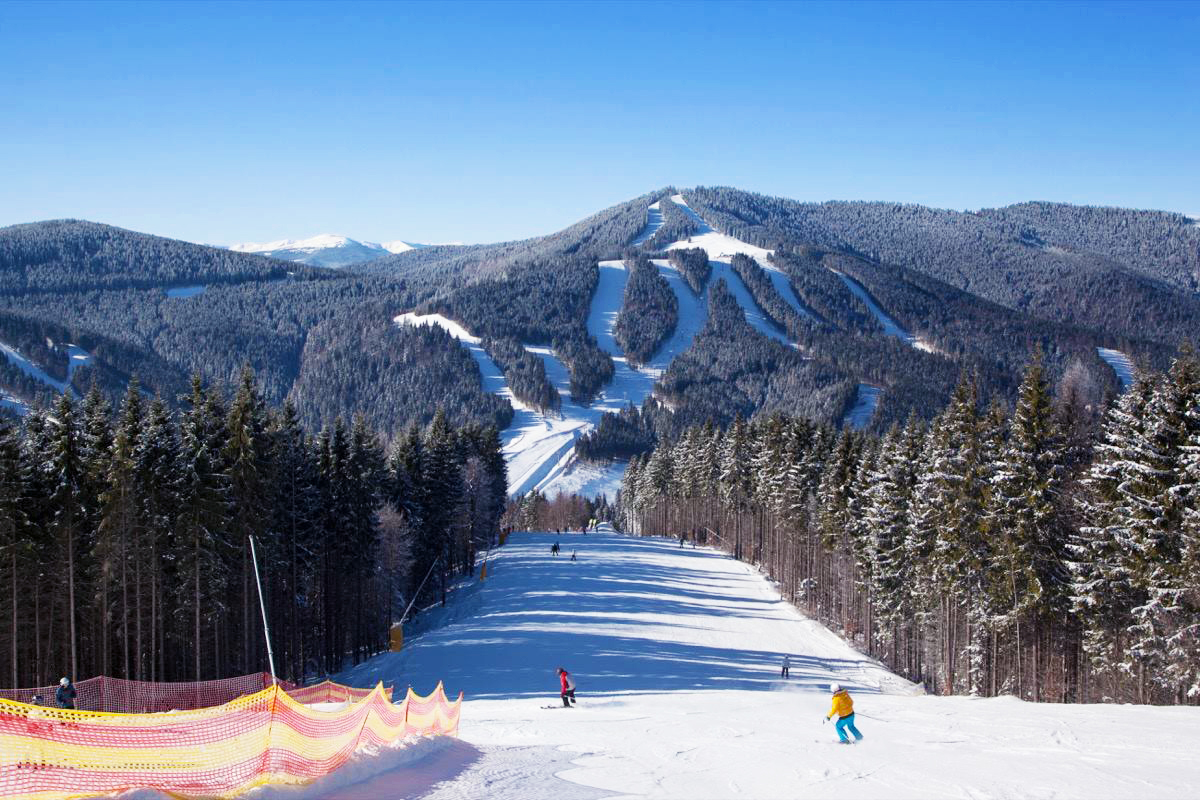
Bukovel is the largest ski resort in Eastern Europe situated in Ukraine, in Nadvirna Raion, Ivano-Frankivsk Oblast (province) of western Ukraine. A part of it is in state property. The resort is located almost on the ridge-lines of the Carpathian Mountains at elevation of above the sea level near the village of Polianytsia (about away). It is one of the most popular ski resorts in the Ukrainian Carpathian Mountains and is situated southwest of the city of Yaremche. In 2012, Bukovel was named the fastest-growing ski resort in the world. History The resort was pioneered in 2000 by a joint venture of Scorzonera Ltd. and Horizont AL as an all-year-round tourist and recreational complex. The research for potential ski fields and cableways of the first stage was conducted in cooperation with Plan-Alp, Austria, and Ecosign, Canada, who also finalized the master plan for the resort. By late 2001, a first 691-meter ski lift was launched at the Northern slope of Mountain Bukovel along wi ... [...More Info...] [...Related Items...] OR: [Wikipedia] [Google] [Baidu] |
Carpathian Mountains
The Carpathian Mountains or Carpathians () are a range of mountains forming an arc across Central Europe. Roughly long, it is the third-longest European mountain range after the Urals at and the Scandinavian Mountains at . The range stretches from the far eastern Czech Republic (3%) and Austria (1%) in the northwest through Slovakia (21%), Poland (10%), Ukraine (10%), Romania (50%) to Serbia (5%) in the south. "The Carpathians" European Travel Commission, in The Official Travel Portal of Europe, Retrieved 15 November 2016 The Carpathian ... [...More Info...] [...Related Items...] OR: [Wikipedia] [Google] [Baidu] |
Yaremche Urban Hromada
Yaremche ( uk, Яре́мче, translit=Jaremče, pl, Jaremcze or Jaremcza) is a city in Nadvirna Raion, Ivano-Frankivsk Oblast (province) of west Ukraine. The city is located at the altitude of around above mean sea level. Yaremche hosts the administration of Yaremche urban hromada, one of the hromadas of Ukraine. Population: . Yaremche hosts the headquarters of the nearby Carpathian National Nature Park. History A possible root of the word "Yaremche" comes from the Turkish. In Turkic languages "yarım" means "half" and "yarımca" means "little half". It was founded in 1787 and received city status on December 30, 1977. In the interwar period (1918–1939) it belonged to Poland and was the most popular tourist center in eastern part of the Carpathian Mountains (in the late 1920s more than 6 000 guests came there yearly). Yaremche was growing year by year in importance and number of tourists. According to some, it had the chance to achieve same importance as other key Polish ... [...More Info...] [...Related Items...] OR: [Wikipedia] [Google] [Baidu] |
Vorokhta
Vorokhta (, ) is an urban-type settlement located in the Carpathian Mountains on Prut RiverVorokhta in . Ukrainian Soviet Encyclopedia. and is part of , . Historically, it is a tourist spa town and later was also turned into a ski resort with several ski-jumping ramps ( Avanhard). Vorokhta hosts the admin ... [...More Info...] [...Related Items...] OR: [Wikipedia] [Google] [Baidu] |
Urban-type Settlement
Urban-type settlementrussian: посёлок городско́го ти́па, translit=posyolok gorodskogo tipa, abbreviated: russian: п.г.т., translit=p.g.t.; ua, селище міського типу, translit=selyshche mis'koho typu, abbreviated: uk, с.м.т., translit=s.m.t.; be, пасёлак гарадскога тыпу, translit=pasiolak haradskoha typu; pl, osiedle typu miejskiego; bg, селище от градски тип, translit=selishte ot gradski tip; ro, așezare de tip orășenesc. is an official designation for a semi-urban settlement (previously called a "town A town is a human settlement. Towns are generally larger than villages and smaller than cities, though the criteria to distinguish between them vary considerably in different parts of the world. Origin and use The word "town" shares an ori ..."), used in several Eastern European countries. The term was historically used in Bulgaria, Poland, and the Soviet Union, and remains in use ... [...More Info...] [...Related Items...] OR: [Wikipedia] [Google] [Baidu] |
Vorokhta Settlement Hromada
Vorokhta (, ) is an urban-type settlement located in the Carpathian Mountains on Prut RiverVorokhta in . Ukrainian Soviet Encyclopedia. and is part of , . Historically, it is a tourist spa town and later was also turned into a ski resort with several ski-jumping ramps ( Avanhard). Vorokhta hosts t ... [...More Info...] [...Related Items...] OR: [Wikipedia] [Google] [Baidu] |
Polianytsia, Nadvirna Raion, Ivano-Frankivsk Oblast
Polianytsia). ( uk, Поляниця; pl, Polanica) is a village in Nadvirna Raion, Ivano-Frankivsk Oblast, Ukraine. It is the administrative centre of the Polianytsia rural hromada. Its population is 615 . History The village of Polianytsia was first mentioned in 1820. During the early 20th century, the village was developed at the behest of Johann II, Prince of Liechtenstein, who owned several properties within the village. A church was built under his supervision in 1912. During World War II, the church, along with the village's school, was destroyed by German forces, and 40 of the town's 300 pre-war residents remained in the village by the war's end. The village is inhabited by ethnic Hutsuls. The village is home to the Bukovel Bukovel is the largest ski resort in Eastern Europe situated in Ukraine, in Nadvirna Raion, Ivano-Frankivsk Oblast (province) of western Ukraine. A part of it is in state property. The resort is located almost on the ridge-lines of the Carpathi ... [...More Info...] [...Related Items...] OR: [Wikipedia] [Google] [Baidu] |
Village
A village is a clustered human settlement or community, larger than a hamlet but smaller than a town (although the word is often used to describe both hamlets and smaller towns), with a population typically ranging from a few hundred to a few thousand. Though villages are often located in rural areas, the term urban village is also applied to certain urban neighborhoods. Villages are normally permanent, with fixed dwellings; however, transient villages can occur. Further, the dwellings of a village are fairly close to one another, not scattered broadly over the landscape, as a dispersed settlement. In the past, villages were a usual form of community for societies that practice subsistence agriculture, and also for some non-agricultural societies. In Great Britain, a hamlet earned the right to be called a village when it built a church. [...More Info...] [...Related Items...] OR: [Wikipedia] [Google] [Baidu] |


.jpg)
