|
Yamatogawa Route
The , signed as Route 6, is one of the routes of the Hanshin Expressway system serving the Keihanshin area in Kansai, Japan. It travels in a west to east direction in Osaka Prefecture, from the Bayshore Route, in Sakai is a city located in Osaka Prefecture, Japan. It has been one of the largest and most important seaports of Japan since the medieval era. Sakai is known for its keyhole-shaped burial mounds, or kofun, which date from the fifth century and inclu ... to the Matsubara Route in Matsubara, with a total length of . See also * * References External links * {{Hanshin Expressway Roads in Osaka Prefecture 6 2013 establishments in Japan ... [...More Info...] [...Related Items...] OR: [Wikipedia] [Google] [Baidu] |
Hanshin Urban Expwy Sign 0006
, derived from the second kanji from and the first kanji from (but in ''on''-reading instead of ''kun''-reading), refers generally to Osaka, Kobe, and the surrounding area in the Kansai region of Japan. In the context of a region of Hyōgo Prefecture, the term is used to refer to the 8 small municipalities (Amagasaki, Ashiya, Inagawa, Itami, Kawanishi, Nishinomiya, Sanda and Takarazuka) located close to the northern coast of Osaka Bay between the two large cities of Kobe and Osaka. In some contexts, the eastern Higashinada and Nada wards of Kobe and Nishiyodagawa Ward of Osaka are also included. The name ''Hanshin'' may also refer to: * Hanshin Department Store, a chain of department stores based in Osaka * Hanshin Electric Railway, a railway that links Osaka and Kobe ** Hanshin Main Line, a line operated by the railway * Hanshin Expressway, a network of tolled highways surrounding Osaka, Kobe, and Kyoto * Hanshin Industrial Region, the industrial region encompassing ... [...More Info...] [...Related Items...] OR: [Wikipedia] [Google] [Baidu] |
Hanshin Expressway
The is a network of expressways surrounding Osaka, Kobe and Kyoto, Japan. Operated by , it opened in 1962. Portions of the Hanshin Expressway about east of Fukae Station collapsed during the Kobe earthquake on 17 January 1995. These sections were rebuilt by 1996. Portions of the Osaka highway are featured in Tokyo Xtreme Racer 3, and the Wangan Midnight Maximum Tune video games from 3 onwards. Routes *1 - Loop Route (Central Osaka) *2 - Yodogawa-Sagan Route (Hokko-kita - Universal Studios Japan) *3 - Kobe Route (Nishi-Nagahori - Amagasaki - Nishinomiya - Kobe) *4 - Bayshore Route ( Osakako - Rinku Town, Kansai Airport) *5 - Bayshore Route (Osakako - Rokko Island) *6 - Yamatogawa Route (Sakai - Matsubara) *7 - Kita-Kobe Route (Igawadani - Shirakawa - Minotani - Arima - Nishinomiya-Yamaguchi) *11 - Ikeda Route (Umeda - Toyonaka - Osaka Airport - Kawanishi - Ikeda) *12 - Moriguchi Route (Kitahama - Moriguchi) *13 - Higashi-Osaka Route (Central Osaka - Higashi-Osaka) *1 ... [...More Info...] [...Related Items...] OR: [Wikipedia] [Google] [Baidu] |
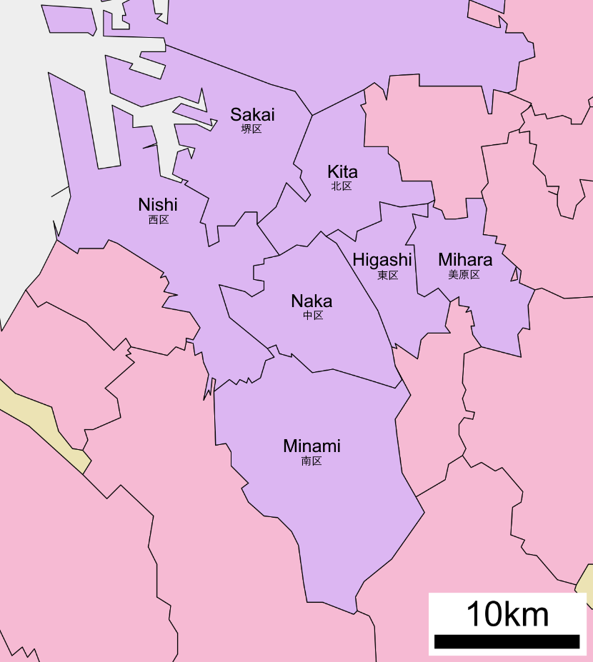
Sakai
is a city located in Osaka Prefecture, Japan. It has been one of the largest and most important seaports of Japan since the medieval era. Sakai is known for its keyhole-shaped burial mounds, or kofun, which date from the fifth century and include Daisen Kofun, the largest grave in the world by area. Once known for swords, Sakai is now famous for the quality of its cutlery. , the city had an estimated population of 819,965, making it the fourteenth most populous city in Japan (excluding Tokyo). Geography Sakai is located in southern Osaka Prefecture, on the edge of Osaka Bay and directly south of the city of Osaka. Neighboring municipalities Osaka Prefecture *Osaka * Matsubara *Habikino *Ōsakasayama *Kawachinagano * Izumi * Takaishi Climate Sakai has a Humid subtropical climate (Köppen ''Cfa'') characterized by warm summers and cool winters with light to no snowfall. The average annual temperature in Sakai is . The average annual rainfall is with June as the wettest mont ... [...More Info...] [...Related Items...] OR: [Wikipedia] [Google] [Baidu] |
Hanshin Urban Expwy Sign 0004
, derived from the second kanji from and the first kanji from (but in ''on''-reading instead of ''kun''-reading), refers generally to Osaka, Kobe, and the surrounding area in the Kansai region of Japan. In the context of a region of Hyōgo Prefecture, the term is used to refer to the 8 small municipalities (Amagasaki, Ashiya, Inagawa, Itami, Kawanishi, Nishinomiya, Sanda and Takarazuka) located close to the northern coast of Osaka Bay between the two large cities of Kobe and Osaka. In some contexts, the eastern Higashinada and Nada wards of Kobe and Nishiyodagawa Ward of Osaka are also included. The name ''Hanshin'' may also refer to: * Hanshin Department Store, a chain of department stores based in Osaka * Hanshin Electric Railway, a railway that links Osaka and Kobe ** Hanshin Main Line, a line operated by the railway * Hanshin Expressway, a network of tolled highways surrounding Osaka, Kobe, and Kyoto * Hanshin Industrial Region, the industrial region encompassing ... [...More Info...] [...Related Items...] OR: [Wikipedia] [Google] [Baidu] |
Bayshore Route (Port Of Osaka-Kansai International Airport)
The signed as Route B, is one of the routes of the tolled Shuto Expressway system in the Greater Tokyo Area. The Bayshore Route is a stretch of toll highway that runs from the Kanazawa ward of Yokohama in the west, northeast to the city of Ichikawa in Chiba Prefecture in the east. Opened in phases beginning in 1976 and ending in 2001, it is an important route that runs between the artificial islands lining the western shore of Tokyo Bay by way of bridges and sub-sea tunnels that bypass central Tokyo. Route description The Bayshore Route is a tolled expressway in the Shuto Expressway network of the Greater Tokyo Area and the only route of the network that serves Chiba Prefecture. It is called Route B after its name in English, Bayshore. The road was constructed by the Metropolitan Expressway Company as a motorway to add capacity to the existing National Route 357. It now runs parallel to the older road, which is used by more local traffic. For administrative purposes, the ... [...More Info...] [...Related Items...] OR: [Wikipedia] [Google] [Baidu] |
Matsubara, Osaka
is a city located in Osaka Prefecture, Japan. , the city had an estimated population of 117,811 in 57351 households and a population density of 7100 persons per km². The total area of the city is . Geography Matsubara is located in the center of Osaka Prefecture. The city measures approximately 5.8 kilometers east-west by 5.1 kilometers north-south, and is mostly flatland. Neighboring municipalities Osaka Prefecture *Osaka ( Sumiyoshi-ku, Higashi Sumiyoshi-ku, Hirano-ku) *Sakai ( Kita-ku, Mihara-ku) * Yao *Fujiidera *Habikino Climate Matsubara has a Humid subtropical climate (Köppen ''Cfa'') characterized by warm summers and cool winters with light to no snowfall. The average annual temperature in Matsubara is 14.9 °C. The average annual rainfall is 1475 mm with September as the wettest month. The temperatures are highest on average in August, at around 27.0 °C, and lowest in January, at around 3.5 °C. Demographics Per Japanese census data, the p ... [...More Info...] [...Related Items...] OR: [Wikipedia] [Google] [Baidu] |
Hanshin Urban Expwy Sign 0014
, derived from the second kanji from and the first kanji from (but in ''on''-reading instead of ''kun''-reading), refers generally to Osaka, Kobe, and the surrounding area in the Kansai region of Japan. In the context of a region of Hyōgo Prefecture, the term is used to refer to the 8 small municipalities (Amagasaki, Ashiya, Inagawa, Itami, Kawanishi, Nishinomiya, Sanda and Takarazuka) located close to the northern coast of Osaka Bay between the two large cities of Kobe and Osaka. In some contexts, the eastern Higashinada and Nada wards of Kobe and Nishiyodagawa Ward of Osaka are also included. The name ''Hanshin'' may also refer to: * Hanshin Department Store, a chain of department stores based in Osaka * Hanshin Electric Railway, a railway that links Osaka and Kobe ** Hanshin Main Line, a line operated by the railway * Hanshin Expressway, a network of tolled highways surrounding Osaka, Kobe, and Kyoto * Hanshin Industrial Region, the industrial region encompassing ... [...More Info...] [...Related Items...] OR: [Wikipedia] [Google] [Baidu] |
Matsubara Route
The , signed as Route 14, is one of the tolled routes of the Hanshin Expressway system serving the Keihanshin area in Kansai, Japan. It travels in a northwest to southeast direction from the Chūō ward of Osaka, beginning at a junction with the Loop Route, to a junction with the Hanwa Expressway, Kinki Expressway, and Nishi-Meihan Expressway in the city of Matsubara. The expressway has a total length of . Route description The Matsubara Route travels in a northwest to southeast direction from the Chūō ward of Osaka, beginning at a junction with the Loop Route, to a junction with the Hanwa Expressway, Kinki Expressway, and Nishi-Meihan Expressway in the city of Matsubara. Serving as the primary expressway route from central Osaka to Matsubara and points beyond in eastern Osaka Prefecture and Nara Prefecture, the highway winds its way through the wards of Osaka. Much of this section of the expressway lies above the Tanimachi Line of the Osaka Metro between Abeno Station and ... [...More Info...] [...Related Items...] OR: [Wikipedia] [Google] [Baidu] |
Keihanshin
is a metropolitan region in the Kansai region of Japan encompassing the metropolitan areas of the cities of Kyoto in Kyoto Prefecture, Osaka in Osaka Prefecture and Kobe in Hyōgo Prefecture. The entire region has a population () of 19,302,746 over an area of .Japan Statistics Bureau - "2015 Census", retrieved June 27, 2021 It is the second-most-populated urban region in Japan (after the ), containing approximately 15% of Japan's population. The |
Osaka Prefecture
is a Prefectures of Japan, prefecture of Japan located in the Kansai region of Honshu. Osaka Prefecture has a population of 8,778,035 () and has a geographic area of . Osaka Prefecture borders Hyōgo Prefecture to the northwest, Kyoto Prefecture to the north, Nara Prefecture to the southeast, and Wakayama Prefecture to the south. Osaka is the capital and largest city of Osaka Prefecture, and the List of cities in Japan, third-largest city in Japan, with other major cities including Sakai, Higashiōsaka, and Hirakata. Osaka Prefecture is the third-most-populous prefecture, but by geographic area the second-smallest; at it is the second-most densely populated, below only Tokyo. Osaka Prefecture is one of Japan's two "Fu (country subdivision), urban prefectures" using the designation ''fu'' (府) rather than the standard ''Prefectures of Japan#Types of prefecture, ken'' for prefectures, along with Kyoto Prefecture. Osaka Prefecture forms the center of the Keihanshin metropolitan ar ... [...More Info...] [...Related Items...] OR: [Wikipedia] [Google] [Baidu] |
Roads In Osaka Prefecture
A road is a linear way for the conveyance of traffic that mostly has an improved surface for use by vehicles (motorized and non-motorized) and pedestrians. Unlike streets, the main function of roads is transportation. There are many types of roads, including parkways, avenues, controlled-access highways (freeways, motorways, and expressways), tollways, interstates, highways, thoroughfares, and local roads. The primary features of roads include lanes, sidewalks (pavement), roadways (carriageways), medians, shoulders, verges, bike paths (cycle paths), and shared-use paths. Definitions Historically many roads were simply recognizable routes without any formal construction or some maintenance. The Organization for Economic Co-operation and Development (OECD) defines a road as "a line of communication (travelled way) using a stabilized base other than rails or air strips open to public traffic, primarily for the use of road motor vehicles running on their own wheels", which i ... [...More Info...] [...Related Items...] OR: [Wikipedia] [Google] [Baidu] |


