|
Yamakuni River
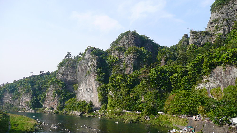
The is a river that flows through the Ōita Prefecture in Japan. In its lower reaches it provides the boundary to the Fukuoka Prefecture to the west. The Yamakuni River arises on the slopes of the sacred Mount Hiko on the border of Oita and Fukuoka prefectures, flowing towards the sea through the Yabakei and Nakatsu plains, and empties into the Seto Inland Sea. Tributaries include the Yamaoi River, Atoda River and Yamautsuri River. It is known as the largest rapid river in Kyushu, and when torrential rain occurs in the upper reaches, a large amount of rain flows down in a short time, which has the characteristic of causing flooding. Structures The Yabakei Dam on a tributary, the Yamautsuri River, and Heisei Ozeki Barrage, help control the river system. The Yabakei Bridge over it, is the longest stone bridge in Japan. Tourism It runs through the Yabakei Gorge (Shinyabakei Gorge) and is adjacent to Aonodōmon (Blue Tunnel) in the Yaba-Hita-Hikosan Quasi-National Park. Its up ... [...More Info...] [...Related Items...] OR: [Wikipedia] [Google] [Baidu] |
Ōita Prefecture
is a prefecture of Japan located on the island of Kyūshū. Ōita Prefecture has a population of 1,136,245 (1 June 2019) and has a geographic area of 6,340 km2 (2,448 sq mi). Ōita Prefecture borders Fukuoka Prefecture to the northwest, Kumamoto Prefecture to the southwest, and Miyazaki Prefecture to the south. Ōita is capital and largest city of Ōita Prefecture, with other major cities including Beppu, Nakatsu, and Saiki. Ōita Prefecture is located in the northeast of Kyūshū on the Bungo Channel, connecting the Pacific Ocean and Seto Inland Sea, across from Ehime Prefecture on the island of Shikoku. Ōita Prefecture is famous for its hot springs and is a popular tourist destination in Japan for its '' onsens'' and '' ryokans'', particularly in and around the city of Beppu. History Around the 6th century Kyushu consisted of four regions: Tsukushi Province, Hi Province, Kumaso Province and Toyo Province. Toyo Province was later divided into two regions, upper and ... [...More Info...] [...Related Items...] OR: [Wikipedia] [Google] [Baidu] |
Structurae
Structurae is an online database containing pictures and information about structural engineering, structural and civil engineering works, and their associated engineers, architects, and builders. Its entries are user-generated content, contributed by volunteers and saved in a MySQL database. Overview Structurae was founded in 1998 by Nicolas Janberg, who had studied civil engineering at Princeton University. In March 2012, Structurae was acquired by , a subsidiary of John Wiley & Sons, Inc., with Janberg joining the company as Structurae's editor-in-chief. At that time, the web site received more than one million pageviews per month, and was available in English, French and German. In 2015, Janberg bought the site back to operate it as a freelancer again. Buildings in the Structurae database References External links * Architecture websites German websites Architecture databases Online databases Databases in Germany {{Database-stub ... [...More Info...] [...Related Items...] OR: [Wikipedia] [Google] [Baidu] |
Rivers Of Fukuoka Prefecture
A river is a natural flowing watercourse, usually freshwater, flowing towards an ocean, sea, lake or another river. In some cases, a river flows into the ground and becomes dry at the end of its course without reaching another body of water. Small rivers can be referred to using names such as creek, brook, rivulet, and rill. There are no official definitions for the generic term river as applied to geographic features, although in some countries or communities a stream is defined by its size. Many names for small rivers are specific to geographic location; examples are "run" in some parts of the United States, "burn" in Scotland and northeast England, and "beck" in northern England. Sometimes a river is defined as being larger than a creek, but not always: the language is vague. Rivers are part of the water cycle. Water generally collects in a river from precipitation through a drainage basin from surface runoff and other sources such as groundwater recharge, springs, a ... [...More Info...] [...Related Items...] OR: [Wikipedia] [Google] [Baidu] |
Typhoon
A typhoon is a mature tropical cyclone that develops between 180° and 100°E in the Northern Hemisphere. This region is referred to as the Northwestern Pacific Basin, and is the most active tropical cyclone basin on Earth, accounting for almost one-third of the world's annual tropical cyclones. For organizational purposes, the northern Pacific Ocean is divided into three regions: the eastern (North America to 140°W), central (140°W to 180°), and western (180° to 100°E). The Regional Specialized Meteorological Center (RSMC) for tropical cyclone forecasts is in Japan, with other tropical cyclone warning centers for the northwest Pacific in Hawaii (the Joint Typhoon Warning Center), the Philippines, and Hong Kong. Although the RSMC names each system, the main name list itself is coordinated among 18 countries that have territories threatened by typhoons each year. Within most of the northwestern Pacific, there are no official typhoon seasons as tropical cyclones form thr ... [...More Info...] [...Related Items...] OR: [Wikipedia] [Google] [Baidu] |
Yaba-Hita-Hikosan Quasi-National Park
is a Quasi-National Park in Fukuoka Prefecture, Kumamoto Prefecture, and Ōita Prefecture, Japan. It was founded on 29 July 1950 and has an area of . See also * Aonodōmon * List of national parks of Japan and in Japan are places of scenic beauty designated for protection and sustainable usage by the Minister of the Environment under the of 1957. National Parks are designated and in principle managed by the Ministry of the Environment. Quasi-Nat ... References National parks of Japan Parks and gardens in Fukuoka Prefecture Parks and gardens in Kumamoto Prefecture Parks and gardens in Ōita Prefecture Protected areas established in 1950 1950 establishments in Japan {{Japan-protected-area-stub ... [...More Info...] [...Related Items...] OR: [Wikipedia] [Google] [Baidu] |
Aonodōmon
is a tourist attraction located in the gorge of Yabakei, now part of Nakatsu City, in Ōita Prefecture, Japan. Legend has it that before the tunnel was built, people had to climb over the cliffs through which the tunnel is built to reach an important local shrine. The path was very dangerous and people regularly fell to their deaths. During the Edo period, a Buddhist monk named Zenkai, who had committed a murder in his earlier life, decided to build a safe passage for worshipers in order to atone for his crime. Beginning at the age of 49, he dedicated 30 years of his life to digging the 185 metre tunnel by hand, using only a hammer and chisel. The tunnel was opened for use in 1763. Aonodōmon was made famous by a popular book written by author Kikuchi Kan , also known as Kan Kikuchi (which uses the same kanji as his real name), was a Japanese author. He established the publishing company Bungeishunjū, the monthly magazine of the same name, the Japan Writer's Association ... [...More Info...] [...Related Items...] OR: [Wikipedia] [Google] [Baidu] |
Yabakei
The gorge of is a nationally designated Place of Scenic Beauty spanning the municipalities of Kusu and Nakatsu in Ōita Prefecture, Japan. Located within Yaba-Hita-Hikosan Quasi-National Park, it was selected as one of the 100 Landscapes of Japan during the Shōwa era. Yabakei was formerly the name of a town, but was merged into Nakatsu Municipality in 2005. According to Fire and Disaster Management Agency of Japan, official confirmed report, in despite the absence of rain, suddenly landslides occurred on the mountain slope, three houses were buried in the place and six people lost their lives on 11 April 2018. Gallery File:Hitome Hakkei01.jpg, Hitome Hakkei viewpoint in Shin Yabakei Gorge File:Tatehata no Kei02.jpg, Tatehata no Kei in Ura Yamakei Gorge See also * Aonodōmon * New Three Views of Japan New is an adjective referring to something recently made, discovered, or created. New or NEW may refer to: Music * New, singer of K-pop group The Boyz Albums and EP ... [...More Info...] [...Related Items...] OR: [Wikipedia] [Google] [Baidu] |
Agency For Cultural Affairs
The is a special body of the Japanese Ministry of Education, Culture, Sports, Science and Technology (MEXT). It was set up in 1968 to promote Japanese arts and culture. The agency's budget for FY 2018 rose to ¥107.7 billion. Overview The agency's Cultural Affairs Division disseminates information about the arts within Japan and internationally, and the Cultural Properties Protection Division protects the nation's cultural heritage. The Cultural Affairs Division is concerned with such areas as art and culture promotion, art copyrights, and improvements in the national language. It also supports both national and local arts and cultural festivals, and it funds traveling cultural events in music, theater, dance, art exhibitions, and film-making. Special prizes are offered to encourage young artists and established practitioners, and some grants are given each year to enable them to train abroad. The agency funds national museums of modern art in Kyoto and Tokyo and The National ... [...More Info...] [...Related Items...] OR: [Wikipedia] [Google] [Baidu] |
Yabakei Bridge
is a Taishō-era stone bridge over the Yamakuni River in Yabakei, Nakatsu, Ōita Prefecture, Japan. Construction work on the eight-arched bridge, built as part of a tourist road for the viewing of the nearby Aonodōmon, began in 1920 and was completed in 1923; repair and restoration work took place in 1999. At in length, it is the longest stone bridge in the country, and has been designated Designation (from Latin ''designatio'') is the process of determining an incumbent's successor. A candidate that won an election for example, is the ''designated'' holder of the office the candidate has been elected to, up until the candidate's i ... an Important Cultural Property. References See also {{Commons category, Yabakei Bridge * List of Places of Scenic Beauty of Japan (Ōita) Bridges in Japan Nakatsu, Ōita Buildings and structures in Ōita Prefecture Important Cultural Properties of Japan Bridges completed in 1923 ... [...More Info...] [...Related Items...] OR: [Wikipedia] [Google] [Baidu] |
Heisei Ozeki Dam
also translated without the redundancy as Heisei-ōzeki (Heisei Great Weir or Barrage) is a mobile barrage dam on the Yamakuni River between Kōge, Fukuoka Prefecture and Nakatsu, Ōita Prefecture in Japan Japan ( ja, 日本, or , and formally , ''Nihonkoku'') is an island country in East Asia. It is situated in the northwest Pacific Ocean, and is bordered on the west by the Sea of Japan, while extending from the Sea of Okhotsk in the north .... It was constructed in phases for flood control and water supply purposes and fully completed in 1991. References Dams in Fukuoka Prefecture Dams completed in 1991 category:Dams in Ōita Prefecture {{Japan-dam-stub ... [...More Info...] [...Related Items...] OR: [Wikipedia] [Google] [Baidu] |
Yabakei Dam
Yabakei Dam ( ja, 耶馬溪ダム) is a dam in the Ōita Prefecture, Japan. Overview The Yabakei Dam is a 62.0 meter high gravity-type concrete dam under the direct control of the Ministry of Land, Infrastructure, Transport and Tourism managed by the Kyushu Regional Development Bureau of the Ministry of Land, Infrastructure, Transport and Tourism. It is the main dam in the Yamakuni River system, and is a specific multipurpose dam for the purpose of hydraulic control, water utilization and hydroelectric power generation from the Yamakuni River's tributary the Yamautsuri River. Together with the Heisei Ozeki Barrage, which is located downstream, it occupies an important position not only in Nakatsu City but also in Kitakyushu City, Fukuoka Prefecture and the Kyogetsu area. * Flood control capacity - 11.2 million m3 * Water utilization capacity - 9.8 million m3 ** Unspecified irrigation water - 5.5 million m3 ** Urban water and power generation (subordinate) - 4.3 million m3 At ... [...More Info...] [...Related Items...] OR: [Wikipedia] [Google] [Baidu] |


