|
Yugoslav Frigate Split
''Split'' (pennant number VPBR-31) was a ''Koni''-class frigate in service with the Yugoslav Navy (JRM). Laid down and completed during the late 1970s as ''Sokol'' of the Soviet Navy, it was the fourth ship of a class that was being built by the Zelenodolsk Shipyard primarily for export to various friendly navies. The ship was acquired by the JRM in 1980 and commissioned as ''Split'', becoming the second ship in JRM service to be named after the city of Split. It was soon followed by a second ''Koni''-class hull, ''Koper'' (VPBR-32), commissioned in the JRM in 1982. Designated as a Large Patrol Boat ( sh, Veliki patrolni brod – VPBR) by the JRM, ''Split's'' original armament consisting of naval guns, anti-submarine rocket launchers and anti-aircraft missiles was further improved by the addition of four P-20 anti-ship missiles, making it the most versatile ship in the JRM inventory at the time. Following the outbreak of the Croatian War of Independence in 1991, ''Split'' wa ... [...More Info...] [...Related Items...] OR: [Wikipedia] [Google] [Baidu] |
Bay Of Kotor
The Bay of Kotor ( Montenegrin and Serbian: , Italian: ), also known as the Boka, is a winding bay of the Adriatic Sea in southwestern Montenegro and the region of Montenegro concentrated around the bay. It is also the southernmost part of the historical region of Dalmatia. The bay has been inhabited since antiquity. Its well-preserved medieval towns of Kotor, Risan, Tivat, Perast, Prčanj and Herceg Novi, along with their natural surroundings, are major tourist attractions. The Natural and Culturo-Historical Region of Kotor was designated a UNESCO World Heritage Site in 1979. Its numerous Orthodox and Catholic churches and monasteries attract numerous religious pilgrims and other visitors. Geography The bay is about long with a shoreline extending . It is surrounded by two massifs of the Dinaric Alps: the Orjen mountains to the west, and the Lovćen mountains to the east. The narrowest section of the bay, the long Verige Strait, is only wide at its narrowes ... [...More Info...] [...Related Items...] OR: [Wikipedia] [Google] [Baidu] |
1991 Yugoslav Campaign In Croatia
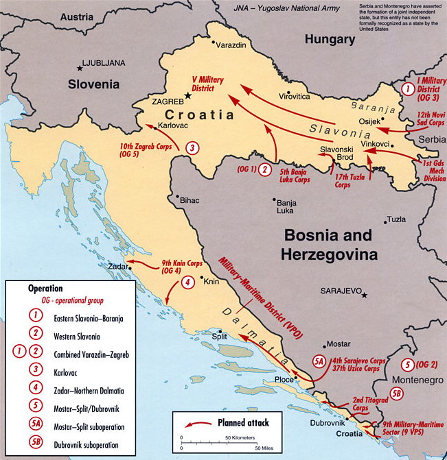
The 1991 Yugoslav campaign in Croatia was a series of engagements between the Yugoslav People's Army (JNA), the Yugoslav Navy and the Yugoslav Air Force, and the Croatian National Guard (ZNG) then the Croatian Army (HV) during the Croatian War of Independence. The JNA was originally deployed in order to preserve Yugoslavia, and the initial plan of the campaign entailed the military occupation of Croatia and the removal of the Croatian leadership elected in 1990. The JNA intervention was the culmination of its involvement in the confiscation of weapons from Croatia's Territorial Defence, and in the Croatian Serb revolt that had begun in August 1990. From that time, the JNA had been frequently deployed to form a buffer zone between the insurgents and the ZNG or the Croatian police. In effect, these JNA buffer zones often secured the territorial gains of the insurgents and led to an increasingly hostile relationship between the JNA and Croatia. The JNA campaign plan was amended shor ... [...More Info...] [...Related Items...] OR: [Wikipedia] [Google] [Baidu] |
Vis (island)
Vis (; ; la, Issa, it, Lissa) is a small Croatian island in the Adriatic Sea. It is the farthest inhabited island off the Croatian mainland. Before the end of World War I, the island was held by the Liburnians, the Republic of Venice, the Napoleonic Kingdom of Italy, and the Austrian Empire. During the 19th century, the sea to the north of Vis was the site of two naval battles. In 1920, the island was ceded to the Kingdom of Yugoslavia as part of the Treaty of Rapallo. During World War II, the island was the headquarters of the Yugoslav Partisan movement. After the war, Vis was used as a naval base for the Yugoslav People's Army until 1989. The island's main industries are viticulture, fishing, fish processing, and tourism. Geography The farthest inhabited island off the Croatian mainland, Vis had a population of 3,617 in 2011. Vis has an area of . Its highest point is Hum, which is above sea level. The island's two largest settlements are the town of Vis on the island' ... [...More Info...] [...Related Items...] OR: [Wikipedia] [Google] [Baidu] |
Coastal Artillery
Coastal artillery is the branch of the armed forces concerned with operating anti-ship artillery or fixed gun batteries in coastal fortifications. From the Middle Ages until World War II, coastal artillery and naval artillery in the form of cannons were highly important to military affairs and generally represented the areas of highest technology and capital cost among materiel. The advent of 20th-century technologies, especially military aviation, naval aviation, jet aircraft, and guided missiles, reduced the primacy of cannons, battleships, and coastal artillery. In countries where coastal artillery has not been disbanded, these forces have acquired amphibious capabilities. In littoral warfare, mobile coastal artillery armed with surface-to-surface missiles can still be used to deny the use of sea lanes. It was long held as a rule of thumb that one shore-based gun equaled three naval guns of the same caliber, due to the steadiness of the coastal gun which allow ... [...More Info...] [...Related Items...] OR: [Wikipedia] [Google] [Baidu] |
Croatian Navy
, image = Seal of Croatian Navy.png , caption = Emblem of the Croatian Navy , start_date = 1991 , country = , allegiance = , branch = , type = Navy , role = , size = 1,36330 vessels , command_structure = Armed Forces of Croatia , garrison = Lora, Split, Croatia , garrison_label = H/Q , nickname = , patron = Saint Nicholas , motto = , colors = , colors_label = , march = ( en, We are Croatian sailors!) , mascot = , battles = Croatian War of IndependenceOperation Atalanta Operation Triton , anniversaries = September 18 , website = https://www.morh.hr/en/ , battle_honors = , identification_symbol = , identification_symbol_label = Ensign , identification_symbol_2 = , identification_symbol_2_label = Jack , commander1 = Commodore Ivo Raffanelli , commander1_label = Commander , commander2 = Ship-of-the-line cpt. Milan Blažević , commander2_label = Deputy Commander,Chief of Naval Staff , ceremonial_chief = , ceremonial_chief_label = , ... [...More Info...] [...Related Items...] OR: [Wikipedia] [Google] [Baidu] |
Brač
Brač is an island in the Adriatic Sea within Croatia, with an area of , making it the largest island in Dalmatia, and the third largest in the Adriatic. It is separated from the mainland by the Brač Channel, which is wide. The island's tallest peak, Vidova gora, or Mount St. Vid, stands at , making it the highest island point of the Adriatic islands. The island has a population of 13,931, living in twenty-two settlements, ranging from the main town Supetar, with more than 3,400 inhabitants, to Murvica, where less than two dozen people live. Brač Airport on Brač is the largest airport of all islands surrounding Split. Brač is known as a tourist destination, for the Zlatni Rat beach in Bol, the marina in Milna, the white limestone which was used for the palace of Diocletian, the stone mason school in Pučišća, the oldest preserved text written in the Croatian language, the author Vladimir Nazor, its olive oil with protected designation of origin, the Kopačina cave ... [...More Info...] [...Related Items...] OR: [Wikipedia] [Google] [Baidu] |
Šolta
Šolta (; it, Solta; la, Solentium) is an island in Croatia. It is situated in the Adriatic Sea in the central Dalmatian archipelago, west of the island of Brač, south of Split (separated by Split Channel) and east of the Drvenik islands, Drvenik Mali and Drvenik Veli (separated by the Šolta Channel). The main settlement is Grohote. Its area is 58.98 km2. and it has a population of 1,700 (). Island morphology The highest peak of Šolta is the summit Vela Straža which is 236 metres high. On the north-eastern coast of the island there are the large bays of Rogač and Nečujam. In the western part of the interior of Šolta there is a field approximately long and wide. Economy The economy of the island is based on vineyards, olives, fruit, fishing and tourism. While the main settlements (Grohote, Gornje Selo, Srednje Selo, Donje Selo) are inland, the main fishing centres are Maslinica, which is exposed to only north-westerly winds, making it a good shelter f ... [...More Info...] [...Related Items...] OR: [Wikipedia] [Google] [Baidu] |
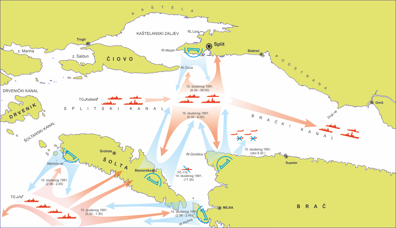
Battle Of The Dalmatian Channels
A battle is an occurrence of combat in warfare between opposing military units of any number or size. A war usually consists of multiple battles. In general, a battle is a military engagement that is well defined in duration, area, and force commitment. An engagement with only limited commitment between the forces and without decisive results is sometimes called a skirmish. The word "battle" can also be used infrequently to refer to an entire operational campaign, although this usage greatly diverges from its conventional or customary meaning. Generally, the word "battle" is used for such campaigns if referring to a protracted combat encounter in which either one or both of the combatants had the same methods, resources, and strategic objectives throughout the encounter. Some prominent examples of this would be the Battle of the Atlantic, Battle of Britain, and Battle of Stalingrad, all in World War II. Wars and military campaigns are guided by military strategy, whereas bat ... [...More Info...] [...Related Items...] OR: [Wikipedia] [Google] [Baidu] |
Croatian War Of Independence
The Croatian War of Independence was fought from 1991 to 1995 between Croat forces loyal to the Government of Croatia—which had declared independence from the Socialist Federal Republic of Yugoslavia (SFRY)—and the Serb-controlled Yugoslav People's Army (JNA) and local Serb forces, with the JNA ending its combat operations in Croatia by 1992. In Croatia, the war is primarily referred to as the "Homeland War" ( hr, Domovinski rat) and also as the " Greater-Serbian Aggression" ( hr, Velikosrpska agresija). In Serbian sources, "War in Croatia" ( sr-cyr, Рат у Хрватској, Rat u Hrvatskoj) and (rarely) "War in Krajina" ( sr-cyr, Рат у Крајини, Rat u Krajini) are used. A majority of Croats wanted Croatia to leave Yugoslavia and become a sovereign country, while many ethnic Serbs living in Croatia, supported by Serbia, opposed the secession and wanted Serb-claimed lands to be in a common state with Serbia. Most Serbs sought a new Serb state within a Y ... [...More Info...] [...Related Items...] OR: [Wikipedia] [Google] [Baidu] |
Anti-ship Missile
An anti-ship missile (AShM) is a guided missile that is designed for use against ships and large boats. Most anti-ship missiles are of the sea skimming variety, and many use a combination of inertial guidance and active radar homing. A good number of other anti-ship missiles use infrared homing to follow the heat that is emitted by a ship; it is also possible for anti-ship missiles to be guided by radio command all the way. The first anti-ship missiles, which were developed and built by Nazi Germany, used radio command guidance.https://airandspace.si.edu/collection-objects/bomb-guided-fritz-x-x-1/nasm_A19840794000#:~:text=The%20Fritz%20X%2C%20also%20known,the%20Henschel%20Hs%20293%20missile. These saw some success in the Mediterranean Theatre during 1943–44, sinking or heavily damaging at least 31 ships with the Henschel Hs 293 and more than seven with the '' Fritz X'', including the Italian battleship ''Roma'' and the light cruiser . A variant of the HS 293 had a TV ... [...More Info...] [...Related Items...] OR: [Wikipedia] [Google] [Baidu] |


.jpg)