|
Xaaga
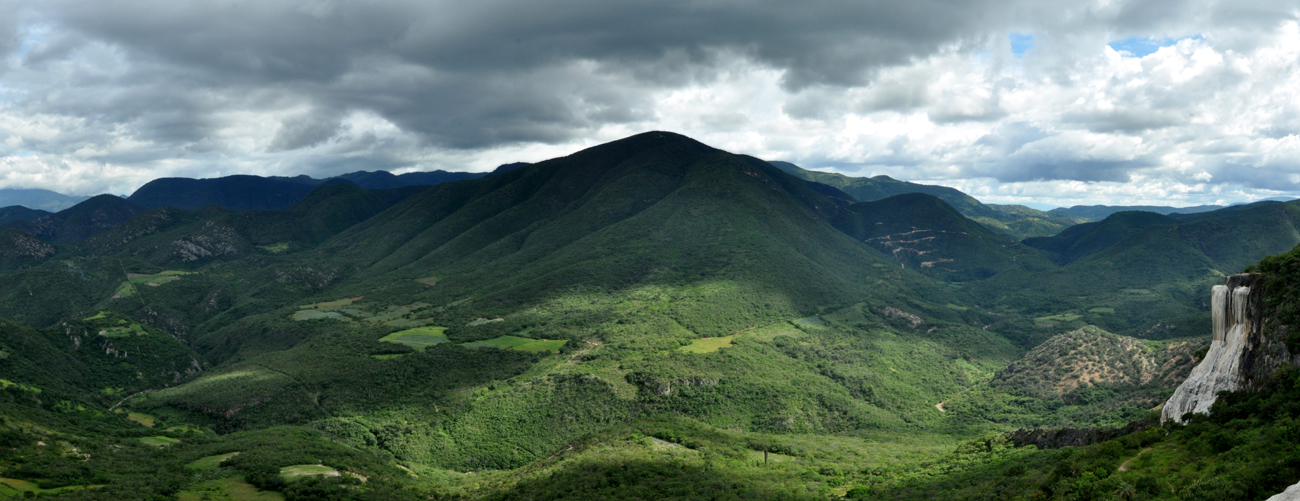
Xaaga (pronounced Saaga) is a small town South-West from the town of San Pablo Villa de Mitla in the Valles Centrales of the State of Oaxaca, Mexico Mexico (Spanish: México), officially the United Mexican States, is a country in the southern portion of North America. It is bordered to the north by the United States; to the south and west by the Pacific Ocean; to the southeast by Guatema .... It is about 10 km (as the crow flies) far away from Hierve el Agua. Populated places in Oaxaca {{Oaxaca-geo-stub ... [...More Info...] [...Related Items...] OR: [Wikipedia] [Google] [Baidu] |
San Pablo Villa De Mitla
San Pablo de Mitla is a town and municipalities of Mexico, municipality in Mexico which is most famous for being the site of the Mitla archeological ruins. It is part of the Tlacolula District, Oaxaca, Tlacolula District in the east of the Valles Centrales de Oaxaca, Valles Centrales Region. The town is also known for its handcrafted textiles, especially embroidered pieces and mezcal. The town also contains a museum which was closed without explanation in 1995, since when its entire collection of Zapotec peoples, Zapotec and Mixtec cultural items has disappeared. The name “San Pablo” is in honor of Saint Paul, and “Mitla” is a hispanization of the Nahuatl name “Mictlán.” This is the name the Aztecs gave the old pre-Hispanic city before Spanish conquest of the Aztec Empire, the Spanish arrived and means “land of the dead.” It is located in the Central Valleys regions of Oaxaca, 46 km from the Oaxaca, Oaxaca, city of Oaxaca, in the District of Tlacolula. Town Th ... [...More Info...] [...Related Items...] OR: [Wikipedia] [Google] [Baidu] |
Valles Centrales De Oaxaca
The Central Valleys ( es, Valles Centrales) of Oaxaca, also simply known as the Oaxaca Valley, is a geographic region located within the modern-day state of Oaxaca in southern Mexico. In an administrative context, it has been defined as comprising the districts of Etla, Centro, Zaachila, Zimatlán, Ocotlán, Tlacolula and Ejutla. The valley, which is located within the Sierra Madre Mountains, is shaped like a distorted and almost upside-down “Y,” with each of its arms bearing specific names: the northwestern Etla arm, the central southern Valle Grande, and the Tlacolula arm to the east. The Oaxaca Valley was home to the Zapotec civilization, one of the earliest complex societies in Mesoamerica, and the later Mixtec culture. A number of important and well-known archaeological sites are found in the Oaxaca Valley, including Monte Albán, Mitla, San José Mogote and Yagul. Today, the capital of the state, Oaxaca City, is located in the central portion of the valley. Histo ... [...More Info...] [...Related Items...] OR: [Wikipedia] [Google] [Baidu] |
Oaxaca
Oaxaca ( , also , , from nci, Huāxyacac ), officially the Free and Sovereign State of Oaxaca ( es, Estado Libre y Soberano de Oaxaca), is one of the 32 states that compose the political divisions of Mexico, Federative Entities of Mexico. It is divided into municipalities of Oaxaca, 570 municipalities, of which 418 (almost three quarters) are governed by the system of (customs and traditions) with recognized local forms of self-governance. Its capital city is Oaxaca de Juárez. Oaxaca is in southwestern Mexico. It is bordered by the states of Guerrero to the west, Puebla to the northwest, Veracruz to the north, and Chiapas to the east. To the south, Oaxaca has a significant coastline on the Pacific Ocean. The state is best known for #Indigenous peoples, its indigenous peoples and cultures. The most numerous and best known are the Zapotec peoples, Zapotecs and the Mixtecs, but there are sixteen that are officially recognized. These cultures have survived better than most others ... [...More Info...] [...Related Items...] OR: [Wikipedia] [Google] [Baidu] |
Mexico
Mexico (Spanish: México), officially the United Mexican States, is a country in the southern portion of North America. It is bordered to the north by the United States; to the south and west by the Pacific Ocean; to the southeast by Guatemala, Belize, and the Caribbean Sea; and to the east by the Gulf of Mexico. Mexico covers ,Mexico ''''. . making it the world's 13th-largest country by are ... [...More Info...] [...Related Items...] OR: [Wikipedia] [Google] [Baidu] |
Hierve El Agua
Hierve el Agua (Spanish for "the water boils") is a set of natural travertine rock formations in San Lorenzo Albarradas, Oaxaca, Mexico that resemble cascades of water. The site is located about 70 km east of Oaxaca City, and consists of two rock shelves or cliffs which rise between fifty and ninety metres from the valley below, from which extend nearly white rock formations which look like waterfalls. These formations are created by fresh water springs, whose water is over-saturated with calcium carbonate and other minerals. As the water trickles over the cliffs, the excess minerals are deposited, much in the same manner that stalactites are formed in caves. One of the cliffs, called the "cascada chica" (small waterfall) or the Amphitheatre, contains two large artificial pools for swimming as well as a number of small natural pools. One of the artificial pools is very near the edge of the cliff. Location The site is located in a very isolated region with rough terrain, do ... [...More Info...] [...Related Items...] OR: [Wikipedia] [Google] [Baidu] |

