|
Wood Lake, Louisiana
Wood Lake ( es, Monte Lacre ; French: ''Bois du Lac'') is an Isleño fishing community in St. Bernard Parish, Louisiana, United States. The community is situated along Bayou Terre-aux-Boeufs to the northeast of Delacroix, Louisiana and west of Lake Lery. Following the American Civil War The American Civil War (April 12, 1861 – May 26, 1865; also known by other names) was a civil war in the United States. It was fought between the Union ("the North") and the Confederacy ("the South"), the latter formed by states th ..., the community was founded by Isleño hunters, trappers, and fisherman. References Unincorporated communities in St. Bernard Parish, Louisiana {{Louisiana-geo-stub ... [...More Info...] [...Related Items...] OR: [Wikipedia] [Google] [Baidu] |
Central Standard Time
The North American Central Time Zone (CT) is a time zone in parts of Canada, the United States, Mexico, Central America, some Caribbean Islands, and part of the Eastern Pacific Ocean. Central Standard Time (CST) is six hours behind Coordinated Universal Time (UTC). During summer, most of the zone uses daylight saving time (DST), and changes to Central Daylight Time (CDT) which is five hours behind UTC. The largest city in the Central Time Zone is Mexico City; the Mexico City metropolitan area is the largest metropolitan area in the zone and in North America. Regions using (North American) Central Time Canada The province of Manitoba is the only province or territory in Canada that observes Central Time in all areas. The following Canadian provinces and territories observe Central Time in the areas noted, while their other areas observe Eastern Time: * Nunavut (territory): western areas (most of Kivalliq Region and part of Qikiqtaaluk Region) * Ontario (province): a port ... [...More Info...] [...Related Items...] OR: [Wikipedia] [Google] [Baidu] |
Spanish Language
Spanish ( or , Castilian) is a Romance languages, Romance language of the Indo-European language family that evolved from colloquial Latin spoken on the Iberian peninsula. Today, it is a world language, global language with more than 500 million native speakers, mainly in the Americas and Spain. Spanish is the official language of List of countries where Spanish is an official language, 20 countries. It is the world's list of languages by number of native speakers, second-most spoken native language after Mandarin Chinese; the world's list of languages by total number of speakers, fourth-most spoken language overall after English language, English, Mandarin Chinese, and Hindustani language, Hindustani (Hindi-Urdu); and the world's most widely spoken Romance languages, Romance language. The largest population of native speakers is in Mexico. Spanish is part of the Iberian Romance languages, Ibero-Romance group of languages, which evolved from several dialects of Vulgar Latin in I ... [...More Info...] [...Related Items...] OR: [Wikipedia] [Google] [Baidu] |
Delacroix, Louisiana
Delacroix ( /ˈdə.lə.krɔɪ/, /ˈdə.lə.krɒ/; Spanish: ''La Isla'' a ˈih.la French: ''L'île de la Croix'') is an Isleño fishing community and census-designated place (CDP) located in St. Bernard Parish, Louisiana. It was first listed as a CDP in the 2020 census with a population of 48. The community is also popularly known as Delacroix Island. The community was established in 1783 with the settlement of Canary Islanders along Bayou Terre-aux-Boeufs. Etymology and usage The community was originally established by Canary Islander colonists during the late 18th century. The area was named La Isla (The Island) and continues to be known as such by many Isleños, particularly those who know Spanish as a first language. On July 3, 1894, the community was renamed to L'île de la Croix after its landowner the Countess Pauline Stéphanie de Livaudais du Suan de la Croix. This name was adjusted later into the English name for the community Delacroix or Delacroix Island. In St ... [...More Info...] [...Related Items...] OR: [Wikipedia] [Google] [Baidu] |
Fishing Village
A fishing village is a village, usually located near a fishing ground, with an economy based on catching fish and harvesting seafood. The continents and islands around the world have coastlines totalling around 356,000 kilometres (221,000 mi). From Neolithic times, these coastlines, as well as the shorelines of inland lakes and the banks of rivers, have been punctuated with fishing villages. Most surviving fishing villages are traditional. Characteristics Coastal fishing villages are often somewhat isolated, and sited around a small natural harbour which provides safe haven for a village fleet of fishing boats. The village needs to provide a safe way of landing fish and securing boats when they are not in use. Fishing villages may operate from a beach, particularly around lakes. For example, around parts of Lake Malawi, each fishing village has its own beach. If a fisherman from outside the village lands fish on the beach, he gives some of the fish to the village headman. ... [...More Info...] [...Related Items...] OR: [Wikipedia] [Google] [Baidu] |
Isleños (Louisiana)
Isleños (french: Islingues) are a Spanish ethnic group living in the state of Louisiana in the United States, consisting of people primarily from the Canary Islands. Isleños are descendants of colonists who settled in Spanish Louisiana between 1778 and 1783 and intermarried with other communities such as Frenchmen, Acadians, Creoles, Hispanic Americans, Filipinos, and other groups, mainly through the nineteenth and early twentieth centuries. In Louisiana, the Isleños originally settled in four communities which included Galveztown, Valenzuela, Barataria, and San Bernardo. Of those settlements, Valenzuela and San Bernardo were the most successful as the other two were plagued with both disease and flooding. The large migration of Acadian refugees to Bayou Lafourche led to the rapid gallicization of the Valenzuela community while San Bernardo was able to preserve much of its unique culture and language into the twenty-first century. However, the transmission of Spanish and other ... [...More Info...] [...Related Items...] OR: [Wikipedia] [Google] [Baidu] |
French Language
French ( or ) is a Romance language of the Indo-European family. It descended from the Vulgar Latin of the Roman Empire, as did all Romance languages. French evolved from Gallo-Romance, the Latin spoken in Gaul, and more specifically in Northern Gaul. Its closest relatives are the other langues d'oïl—languages historically spoken in northern France and in southern Belgium, which French ( Francien) largely supplanted. French was also influenced by native Celtic languages of Northern Roman Gaul like Gallia Belgica and by the ( Germanic) Frankish language of the post-Roman Frankish invaders. Today, owing to France's past overseas expansion, there are numerous French-based creole languages, most notably Haitian Creole. A French-speaking person or nation may be referred to as Francophone in both English and French. French is an official language in 29 countries across multiple continents, most of which are members of the ''Organisation internationale de la Francophonie'' ... [...More Info...] [...Related Items...] OR: [Wikipedia] [Google] [Baidu] |
Geographic Names Information System
The Geographic Names Information System (GNIS) is a database of name and locative information about more than two million physical and cultural features throughout the United States and its territories, Antarctica, and the associated states of the Marshall Islands, Federated States of Micronesia, and Palau. It is a type of gazetteer. It was developed by the United States Geological Survey (USGS) in cooperation with the United States Board on Geographic Names (BGN) to promote the standardization of feature names. Data were collected in two phases. Although a third phase was considered, which would have handled name changes where local usages differed from maps, it was never begun. The database is part of a system that includes topographic map names and bibliographic references. The names of books and historic maps that confirm the feature or place name are cited. Variant names, alternatives to official federal names for a feature, are also recorded. Each feature receives a per ... [...More Info...] [...Related Items...] OR: [Wikipedia] [Google] [Baidu] |
Area Code 504
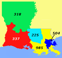
Area code 504 is a telephone area code that covers greater New Orleans, Louisiana. Besides New Orleans itself (Orleans Parish), it includes all of St. Bernard and Plaquemines parishes and most of Jefferson Parish. 504 was one of the original area codes created in 1947, and originally covered all of Louisiana. In 1957, most of the state west of the Mississippi River was split off as area code 318. In 1998, the western portion of the old 504 territory, including Baton Rouge, became area code 225. In 2001, much of southeastern Louisiana was split off as area code 985, to both the west and the north of 504. Several of New Orleans' downriver suburbs switched to 985 in 2001 as well. However, much of this area switched back to 504 in 2007. These communities are now being served with dialtone from telephone switching facilities in New Orleans following near-total destruction of local switching facilities due to flooding from Hurricane Katrina. Permissive dialing of 504 alongside 985 ... [...More Info...] [...Related Items...] OR: [Wikipedia] [Google] [Baidu] |
Unincorporated Area
An unincorporated area is a region that is not governed by a local municipal corporation. Widespread unincorporated communities and areas are a distinguishing feature of the United States and Canada. Most other countries of the world either have no unincorporated areas at all or these are very rare: typically remote, outlying, sparsely populated or List of uninhabited regions, uninhabited areas. By country Argentina In Argentina, the provinces of Chubut Province, Chubut, Córdoba Province (Argentina), Córdoba, Entre Ríos Province, Entre Ríos, Formosa Province, Formosa, Neuquén Province, Neuquén, Río Negro Province, Río Negro, San Luis Province, San Luis, Santa Cruz Province, Argentina, Santa Cruz, Santiago del Estero Province, Santiago del Estero, Tierra del Fuego Province, Argentina, Tierra del Fuego, and Tucumán Province, Tucumán have areas that are outside any municipality or commune. Australia Unlike many other countries, Australia has only local government in Aus ... [...More Info...] [...Related Items...] OR: [Wikipedia] [Google] [Baidu] |
Stilt House
Stilt houses (also called pile dwellings or lake dwellings) are houses raised on stilts (or piles) over the surface of the soil or a body of water. Stilt houses are built primarily as a protection against flooding; they also keep out vermin. The shady space under the house can be used for work or storage. Arctic Houses where permafrost is present, in the Arctic, are built on stilts to keep permafrost under them from melting. Permafrost can be up to 70% water. While frozen, it provides a stable foundation. However, if heat radiating from the bottom of a home melts the permafrost, the home goes out of level and starts sinking into the ground. Other means of keeping the permafrost from melting are available, but raising the home off the ground on stilts is one of the most effective ways. Indo-Pacific Raised rectangular houses are one of the cultural hallmarks of the Austronesian peoples and are found throughout the regions in Island Southeast Asia, Island Melanesia, Micrones ... [...More Info...] [...Related Items...] OR: [Wikipedia] [Google] [Baidu] |
Louisiana (New France)
Louisiana (french: La Louisiane; ''La Louisiane Française'') or French Louisiana was an administrative district of New France. Under French control from 1682 to 1769 and 1801 (nominally) to 1803, the area was named in honor of King Louis XIV, by French explorer René-Robert Cavelier, Sieur de la Salle. It originally covered an expansive territory that included most of the drainage basin of the Mississippi River and stretched from the Great Lakes to the Gulf of Mexico and from the Appalachian Mountains to the Rocky Mountains. Louisiana included two regions, now known as Upper Louisiana (), which began north of the Arkansas River, and ''Lower Louisiana'' (). The U.S. state of Louisiana is named for the historical region, although it is only a small part of the vast lands claimed by France.La Louisiane française 1682-1803 ... [...More Info...] [...Related Items...] OR: [Wikipedia] [Google] [Baidu] |

.jpg)


