|
Wisconsin's 7th Congressional District
Wisconsin's 7th congressional district is a congressional district of the United States House of Representatives in northwestern and central Wisconsin; it is the largest congressional district in the state geographically, covering 20 counties (in whole or part), for a total of 18,787 sq mi. The district contains the following counties: Ashland, Barron, Bayfield, Burnett, St. Croix, Chippewa (partial), Clark, Douglas, Florence, Forest, Iron, Jackson (partial), Juneau (partial), Langlade, Lincoln, Marathon, Monroe (partial), Oneida, Polk, Price, Rusk, Sawyer, Taylor, Vilas, Washburn, and Wood (partial). The district is currently represented by Republican Tom Tiffany. While in 2008, the district gave 56% of the vote to Barack Obama, it has swung to the Republicans in recent presidential elections with Mitt Romney winning with 51% of the vote in 2012 and Donald Trump winning with 58% of the vote in 2016. Additionally, left-leaning Portage County (which contai ... [...More Info...] [...Related Items...] OR: [Wikipedia] [Google] [Baidu] |
Tom Tiffany
Thomas P. Tiffany (born December 30, 1957) is an American businessman and politician serving as the U.S. representative for Wisconsin's 7th congressional district since 2020. A member of the Republican Party, he was elected to the Wisconsin State Assembly in 2011 and the Wisconsin Senate in 2013. Tiffany succeeded Sean Duffy in Congress, winning a special election against Democrat Tricia Zunker. Early life and education Tiffany was born in Wabasha, Minnesota, and grew up on a dairy farm near Elmwood, Pierce County, Wisconsin, with five brothers and two sisters. He graduated from Elmwood High School in 1976 and earned his B.S. in agricultural economics from the University of Wisconsin–River Falls in 1980. Private career Tiffany managed the petroleum division of a farm cooperative in Plainview, Minnesota, before moving to Minocqua, Wisconsin, to manage Zenker Oil Company's petroleum distribution in 1988. He and his wife, Chris, have operated an excursion business on ... [...More Info...] [...Related Items...] OR: [Wikipedia] [Google] [Baidu] |
Lincoln County, Wisconsin
Lincoln County is a county located in the U.S. state of Wisconsin. As of the 2020 census, the population was 28,415. Its county seat is Merrill. The county was created in 1875 and named after President Abraham Lincoln. Lincoln County comprises the Merrill, WI Micropolitan Statistical Area, which is also included in the Wausau- Stevens Point- Wisconsin Rapids, WI Combined Statistical Area. Geography According to the U.S. Census Bureau, the county has a total area of , of which is land and (3.1%) is water. Adjacent counties * Oneida County - north * Langlade County - east * Marathon County - south * Taylor County - west * Price County - northwest Major highways * U.S. Highway 8 * U.S. Highway 51 * Highway 17 (Wisconsin) * Highway 64 (Wisconsin) * Highway 86 (Wisconsin) * Highway 107 (Wisconsin) Railroads * Tomahawk Railway * Watco Buses * List of intercity bus stops in Wisconsin Airports * KRRL - Merrill Municipal Airport * KTKV - Tomahawk Regional Airp ... [...More Info...] [...Related Items...] OR: [Wikipedia] [Google] [Baidu] |
Barack Obama
Barack Hussein Obama II ( ; born August 4, 1961) is an American politician who served as the 44th president of the United States from 2009 to 2017. A member of the Democratic Party (United States), Democratic Party, Obama was the first African-American president of the United States. He previously served as a U.S. senator from Illinois from 2005 to 2008 and as an Illinois state senator from 1997 to 2004, and previously worked as a civil rights lawyer before entering politics. Obama was born in Honolulu, Hawaii. After graduating from Columbia University in 1983, he worked as a Community organizing, community organizer in Chicago. In 1988, he enrolled in Harvard Law School, where he was the first black president of the ''Harvard Law Review''. After graduating, he became a civil rights attorney and an academic, teaching constitutional law at the University of Chicago Law School from 1992 to 2004. Turning to elective politics, he Illinois Senate career of Barack Obama, repre ... [...More Info...] [...Related Items...] OR: [Wikipedia] [Google] [Baidu] |
2008 United States Presidential Election
The 2008 United States presidential election was the 56th quadrennial presidential election, held on Tuesday, November 4, 2008. The Democratic ticket of Barack Obama, the junior senator from Illinois, and Joe Biden, the senior senator from Delaware, defeated the Republican ticket of John McCain, the senior senator from Arizona, and Sarah Palin, the governor of Alaska. Obama became the first African American to be elected to the presidency, as well as being only the third sitting United States senator elected president, joining Warren G. Harding and John F. Kennedy. Meanwhile, Biden became the first senator running mate of a senator elected president since Lyndon B. Johnson (who was Kennedy's running mate) in the 1960 election. Incumbent Republican President George W. Bush was ineligible to pursue a third term due to the term limits established by the 22nd Amendment. McCain secured the Republican nomination by March 2008, defeating former governors Mitt Romney, Mi ... [...More Info...] [...Related Items...] OR: [Wikipedia] [Google] [Baidu] |
Wood County, Wisconsin
Wood County is a county located in the U.S. state of Wisconsin. As of the 2020 census, the population was 74,207. Its county seat is Wisconsin Rapids. The county is named after Joseph Wood, a member of the Wisconsin State Assembly. Wood County comprises the Wisconsin Rapids- Marshfield, WI Micropolitan Statistical Area and is included in the Wausau- Stevens Point-Wisconsin Rapids, WI Combined Statistical Area. Geography According to the U.S. Census Bureau, the county has a total area of , of which is land and (2.0%) is water. The geographic center of Wisconsin is in Wood County, nine miles southeast of Marshfield. Wood County spans two of Wisconsin's five geographical regions. The northern part of the county is in the Northern Highlands, with mostly rich cropland with heavy clay soil, used for corn, soybeans, hay and dairy. In the northwest corner the Marshfield moraine runs from Marathon County through Marshfield, Bakerville and Nasonville into Clark County. The sou ... [...More Info...] [...Related Items...] OR: [Wikipedia] [Google] [Baidu] |
Washburn County, Wisconsin
Washburn County is a county in the U.S. state of Wisconsin. It is named after Governor Cadwallader C. Washburn. As of the 2020 census, the population was 16,623. Its county seat is Shell Lake. The county was created in 1883. Geography According to the U.S. Census Bureau, the county has a total area of , of which is land and (6.6%) is water. Major highways * U.S. Highway 53 * U.S. Highway 63 * Highway 48 (Wisconsin) * Highway 70 (Wisconsin) * Highway 77 (Wisconsin) * Highway 253 (Wisconsin) Railroads *Canadian National *Wisconsin Great Northern Railroad Buses * List of intercity bus stops in Wisconsin Airport Shell Lake Municipal Airport (KSSQ) serves the county and surrounding communities. Adjacent counties * Douglas County - north * Bayfield County - northeast * Sawyer County - east * Rusk County - southeast * Barron County - south * Burnett County - west National protected area * Saint Croix National Scenic Riverway (part) Demographics 2020 ... [...More Info...] [...Related Items...] OR: [Wikipedia] [Google] [Baidu] |
Vilas County, Wisconsin
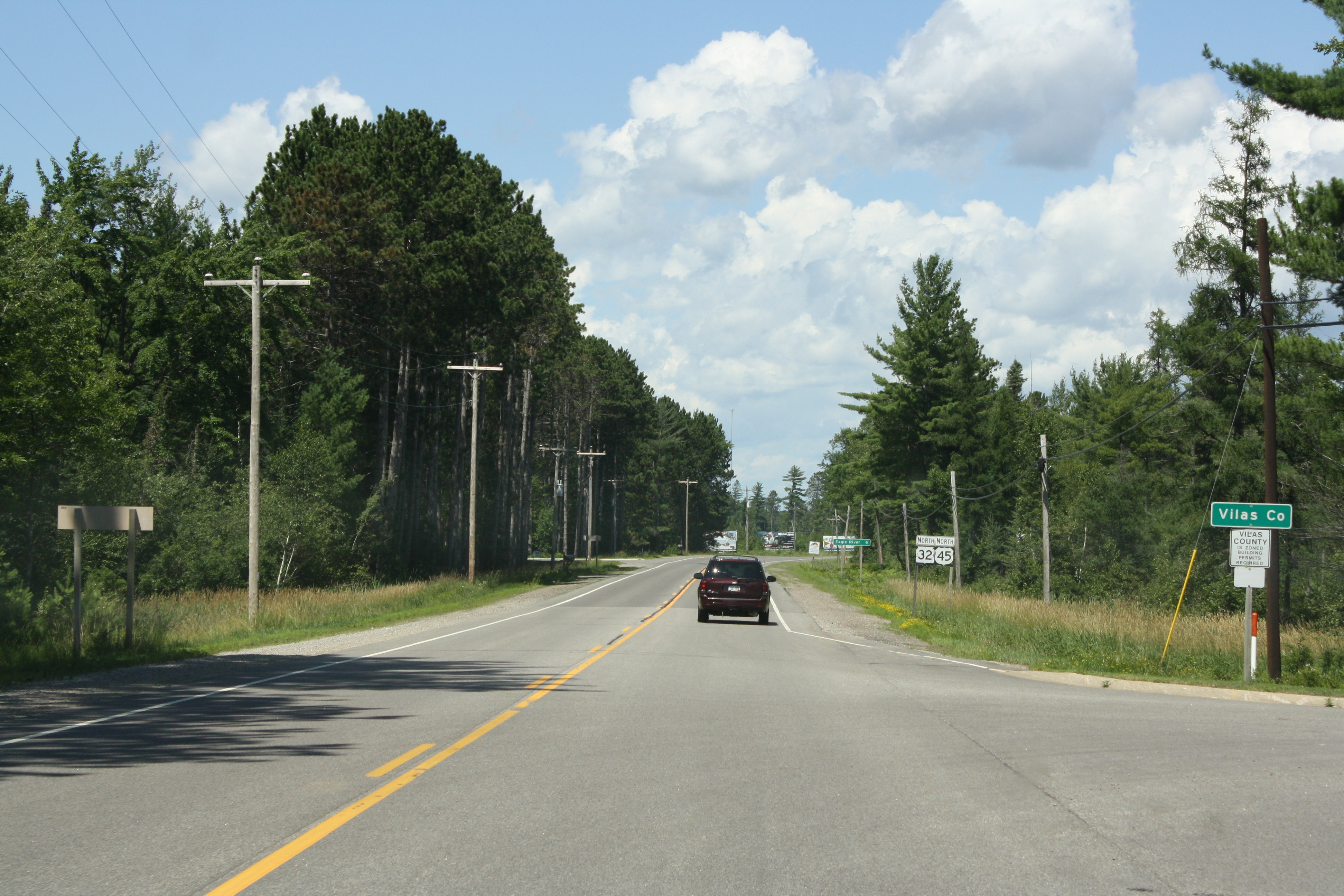
Vilas County is a county in the state of Wisconsin, United States. As of the 2020 census, the population was 23,047. Its county seat is Eagle River. The county partly overlaps the reservation of the Lac du Flambeau Band of Lake Superior Chippewa. History Native Americans Native Americans have lived in what is now Vilas County for thousands of years. The county contains archaeological sites dating to the prehistoric Woodland period. In the eighteenth century, the area was disputed by the Dakota and Ojibwe people. According to oral histories, the conflict culminated in Ojibwe victory in a battle on Strawberry Island in Flambeau Lake around 1745. Ojibwe people have continued to live in the area ever since, securing the Lac du Flambeau Indian Reservation in the 1854 Treaty of La Pointe. Settlement The first recorded white settler was a man named Ashman who established a trading post in Lac du Flambeau in 1818. [...More Info...] [...Related Items...] OR: [Wikipedia] [Google] [Baidu] |
Taylor County, Wisconsin
Taylor County is a county in the U.S. state of Wisconsin. As of the 2020 census, the population was 19,913. Its county seat is Medford. History The earliest recorded event in Taylor county probably occurred in 1661, when Wisconsin was claimed by New France. A band of Huron Indians from eastern Ontario had fled the Iroquois and taken refuge near the headwaters of the Black River, probably around Lake Chelsea in the northeast part of the county. Father René Menard, a French Jesuit priest who had travelled up the Great Lakes as far as Keweenaw Bay in upper Michigan, heard that these Hurons were starving. He decided to try to reach them to baptize them, despite his own weak health and scant supplies. In mid-summer he and a French fur trader set out, following rivers and streams in birchbark canoes down into Wisconsin. Finally, a day's journey from the Huron camp, Father Menard separated from his travelling companion at a rapids to carry some supplies. He was never see ... [...More Info...] [...Related Items...] OR: [Wikipedia] [Google] [Baidu] |
Sawyer County, Wisconsin
Sawyer County is a county in the U.S. state of Wisconsin. As of the 2020 census, the population was 18,074. Its county seat is Hayward. The county partly overlaps with the reservation of the Lac Courte Oreilles Band of Lake Superior Chippewa Indians. History The area that is now Sawyer County was contested between the Dakota and Ojibwe people in the eighteenth century. Oral histories tell that the Ojibwes defeated the Dakotas locally in the Battle of the Horse Fly on the Upper Chippewa River in the 1790s. By this time Lac Courte Oreilles had become the site of an Ojibwe village. Ojibwes allowed trader Michel Cadotte to build a fur trade outpost in the area in 1800. The United States acquired the region from the Ojibwe nation in the 1837 Treaty of St. Peters, but the Ojibwes retained the right to hunt and fish on treaty territory. Ojibwe people successfully negotiated to establish the permanent Lac Courte Oreilles Indian Reservation in the 1854 Treaty of La Pointe. The coun ... [...More Info...] [...Related Items...] OR: [Wikipedia] [Google] [Baidu] |
Rusk County, Wisconsin
Rusk County is a county in the U.S. state of Wisconsin. As of the 2020 census, the population was 14,188. Its county seat is Ladysmith. History Founded in 1901, Rusk County was originally named Gates County after Milwaukee land speculator James L. Gates. It was renamed Rusk County in 1905 after Jeremiah M. Rusk, governor of Wisconsin and the first U.S. Secretary of Agriculture. It was formed out of the northern portion of Chippewa County. Geography According to the U.S. Census Bureau, the county has an area of , of which is land and (1.9%) is water. Adjacent counties * Washburn County - northwest * Sawyer County - north * Price County - east * Taylor County - southeast * Chippewa County - south * Barron County - west Major highways * U.S. Highway 8 * Highway 27 (Wisconsin) * Highway 40 (Wisconsin) * Highway 73 (Wisconsin) Railroads *Canadian National * Watco Buses * List of intercity bus stops in Wisconsin Airport * KRCX - Rusk County Airport serves th ... [...More Info...] [...Related Items...] OR: [Wikipedia] [Google] [Baidu] |
Price County, Wisconsin
Price County is a county in the U.S. state of Wisconsin. As of the 2020 census, the population was 14,054. Its county seat is Phillips. History Price County was created on March 3, 1879, when Wisconsin Governor William E. Smith signed legislation creating the county. The county was later organized in 1882. William T. Price (1824–1886), for whom Price County was named, was President of the Wisconsin Senate and an early logger in Price County; he later was elected to the U.S. Congress. The county was formed from portions of Chippewa and Lincoln counties. The first white settler in what is now Price County was Major Isaac Stone, who located on the Spirit River in 1860 to engage in lumbering. Price County continues today to be a large producer of raw timber. Geography According to the U.S. Census Bureau, the county has a total area of , of which is land and (1.9%) is water. The highest natural point in Wisconsin, Timms Hill at 1,951 feet (595 m), is located in Price Coun ... [...More Info...] [...Related Items...] OR: [Wikipedia] [Google] [Baidu] |
Polk County, Wisconsin
Polk County is a county in the U.S. state of Wisconsin. As of the 2020 census, the population was 44,977. Its county seat is Balsam Lake. The county was created in 1853. Geography According to the U.S. Census Bureau, the county has an area of , of which is land and (4.4%) is water. Adjacent counties * Burnett County - north * Barron County - east * Dunn County - southeast * St. Croix County - south * Washington County, Minnesota - southwest * Chisago County, Minnesota - west Major highways Railroads *Canadian National * Minnesota Transportation Museum Buses * List of intercity bus stops in Wisconsin Airports * Amery Municipal Airport (KAHH) serves the county and surrounding communities. * L.O. Simenstad Municipal Airport (KOEO). National protected area * Saint Croix National Scenic Riverway (part) Demographics 2020 census As of the census of 2020, the population was 44,977. The population density was . There were 24,129 housing units at an average dens ... [...More Info...] [...Related Items...] OR: [Wikipedia] [Google] [Baidu] |


