|
Williamstown, Kansas
Williamstown is an unincorporated community in southeastern Jefferson County, Kansas, United States. As of the 2020 census, the population of the community and nearby areas was 96. It is located south of the junction of US-24 and US-59 highways. History Kaw Agency and Chief White Plume In 1825, the U.S. Government built a stone house for Chief White Plume, the Kaw chief from the band known as the Half-breeds. Kaw Half-Breed Tract #23 became the site of the Kaw Agency in 1827. The house was located approximately 50 yards north of the Kansas Pacific depot. By time the town was plotted in 1865, the stone house was in disrepair. However, the creek named after the old stone house was still a good place to settle, and so Williamstown was founded on its banks in 1865. Founding Williamstown was founded in 1865 in the Kansas River valley near the Union Pacific Railroad and on the banks of Stone House Creek by local property owners Mapes, Williams & Moore. It was originally in ... [...More Info...] [...Related Items...] OR: [Wikipedia] [Google] [Baidu] |
Unincorporated Area
An unincorporated area is a region that is not governed by a local municipal corporation. Widespread unincorporated communities and areas are a distinguishing feature of the United States and Canada. Most other countries of the world either have no unincorporated areas at all or these are very rare: typically remote, outlying, sparsely populated or List of uninhabited regions, uninhabited areas. By country Argentina In Argentina, the provinces of Chubut Province, Chubut, Córdoba Province (Argentina), Córdoba, Entre Ríos Province, Entre Ríos, Formosa Province, Formosa, Neuquén Province, Neuquén, Río Negro Province, Río Negro, San Luis Province, San Luis, Santa Cruz Province, Argentina, Santa Cruz, Santiago del Estero Province, Santiago del Estero, Tierra del Fuego Province, Argentina, Tierra del Fuego, and Tucumán Province, Tucumán have areas that are outside any municipality or commune. Australia Unlike many other countries, Australia has only local government in Aus ... [...More Info...] [...Related Items...] OR: [Wikipedia] [Google] [Baidu] |
Geographic Names Information System
The Geographic Names Information System (GNIS) is a database of name and locative information about more than two million physical and cultural features throughout the United States and its territories, Antarctica, and the associated states of the Marshall Islands, Federated States of Micronesia, and Palau. It is a type of gazetteer. It was developed by the United States Geological Survey (USGS) in cooperation with the United States Board on Geographic Names (BGN) to promote the standardization of feature names. Data were collected in two phases. Although a third phase was considered, which would have handled name changes where local usages differed from maps, it was never begun. The database is part of a system that includes topographic map names and bibliographic references. The names of books and historic maps that confirm the feature or place name are cited. Variant names, alternatives to official federal names for a feature, are also recorded. Each feature receives a per ... [...More Info...] [...Related Items...] OR: [Wikipedia] [Google] [Baidu] |
Census-designated Place
A census-designated place (CDP) is a concentration of population defined by the United States Census Bureau for statistical purposes only. CDPs have been used in each decennial census since 1980 as the counterparts of incorporated places, such as self-governing cities, towns, and villages, for the purposes of gathering and correlating statistical data. CDPs are populated areas that generally include one officially designated but currently unincorporated community, for which the CDP is named, plus surrounding inhabited countryside of varying dimensions and, occasionally, other, smaller unincorporated communities as well. CDPs include small rural communities, edge cities, colonias located along the Mexico–United States border, and unincorporated resort and retirement communities and their environs. The boundaries of any CDP may change from decade to decade, and the Census Bureau may de-establish a CDP after a period of study, then re-establish it some decades later. Most unin ... [...More Info...] [...Related Items...] OR: [Wikipedia] [Google] [Baidu] |
United States Census Bureau
The United States Census Bureau (USCB), officially the Bureau of the Census, is a principal agency of the U.S. Federal Statistical System, responsible for producing data about the American people and economy. The Census Bureau is part of the U.S. Department of Commerce and its director is appointed by the President of the United States. The Census Bureau's primary mission is conducting the U.S. census every ten years, which allocates the seats of the U.S. House of Representatives to the states based on their population. The bureau's various censuses and surveys help allocate over $675 billion in federal funds every year and it assists states, local communities, and businesses make informed decisions. The information provided by the census informs decisions on where to build and maintain schools, hospitals, transportation infrastructure, and police and fire departments. In addition to the decennial census, the Census Bureau continually conducts over 130 surveys and programs ... [...More Info...] [...Related Items...] OR: [Wikipedia] [Google] [Baidu] |
Great Flood Of 1951
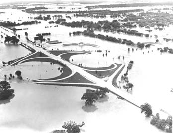
In mid-July 1951, heavy rains led to a great rise of water in the Kansas River, Missouri River, and other surrounding areas of the Central United States. Flooding occurred in the Kansas, Neosho, Marais Des Cygnes, and Verdigris river basins. The damage in June and July 1951 across eastern Kansas and Missouri exceeded (equivalent to $ in ). The flooding killed 17 people and displaced 518,000 more. Flood The 1951 flood in Kansas began in May with the flood of the Big Creek, (a tributary of the Smoky Hill River) in Hays after eleven inches of rain in two hours. The creek overflowed, flooding Hays (the location of Fort Hays State University) to a depth of four feet in most locations inhabited by the coeds on campus, necessitating a midnight flight from the barracks (by families of the G.I. Bill) and dorms to the Stadium's third floor, which was still dry. Dr. Charles F. Wiest, Emeritus Professor of Philosophy and Religion, and his seven-year-old daughter perished when their h ... [...More Info...] [...Related Items...] OR: [Wikipedia] [Google] [Baidu] |
Perry, Kansas
Perry is a city in Jefferson County, Kansas, United States. As of the 2020 census, the population of the city was 852. History Perry had its start in the year 1865 by the building of the railroad through that territory. It was named for John D. Perry, the President of the Kansas Pacific Railroad. The first post office in Perry was established in October 1866. Geography Perry is located at (39.075458, -95.391902). According to the United States Census Bureau, the city has a total area of , all of it land. Climate The climate in this area is characterized by hot, humid summers and generally mild to cool winters. According to the Köppen Climate Classification system, Perry has a humid subtropical climate, abbreviated "Cfa" on climate maps. Demographics Perry is part of the Topeka, Kansas Metropolitan Statistical Area. 2010 census As of the census of 2010, there were 929 people, 375 households, and 254 families living in the city. The population density was . There were 3 ... [...More Info...] [...Related Items...] OR: [Wikipedia] [Google] [Baidu] |
Rural Township, Jefferson County, Kansas
Rural Township is a township in Jefferson County, Kansas, USA. It was formed in 1871, from the territory of Kentucky Township and Sarcoxie Township. As of the 2000 census, its population was 804. Geography Rural Township covers an area of 32.19 square miles (83.37 square kilometers); of this, 0.37 square miles (0.95 square kilometers) or 1.14 percent is water. The streams of Buck Creek, East Stone House Creek, Stone Horse Creek and West Stone House Creek run through this township. Unincorporated towns * Buck Creek * Williamstown (This list is based on USGS data and may include former settlements.) Adjacent townships * Oskaloosa Township (north) * Sarcoxie Township (east) * Grant Township, Douglas County (southeast) * Wakarusa Township, Douglas County (south) * Lecompton Township, Douglas County (southwest) * Kentucky Township (west) Cemeteries The township contains three cemeteries: Buster, Holliday and Underwood. Major highways * U.S. Route 24 U.S. Route 24 (U ... [...More Info...] [...Related Items...] OR: [Wikipedia] [Google] [Baidu] |
Sarcoxie Township, Jefferson County, Kansas
Sarcoxie Township is a township in Jefferson County, Kansas, USA. As of the 2000 census, its population was 958. Geography Sarcoxie Township covers an area of 31.03 square miles (80.36 square kilometers); of this, 0.14 square miles (0.36 square kilometers) or 0.45 percent is water. The stream of Plum Creek runs through this township. Adjacent townships * Union Township (north) * Tonganoxie Township, Leavenworth County (northeast) * Reno Township, Leavenworth County (southeast) * Grant Township, Douglas County (south) * Rural Township (west) * Oskaloosa Township (northwest) Cemeteries The township contains one cemetery, Hardy Oak. Major highways * U.S. Route 24 U.S. Route 24 (US 24) is one of the original United States highways of 1926. It originally ran from Pontiac, Michigan, in the east to Kansas City, Missouri, in the west. Today, the highway's eastern terminus is in Independence Township, Mic .../ U.S. Route 59 References U.S. Board on Geographic Names ( ... [...More Info...] [...Related Items...] OR: [Wikipedia] [Google] [Baidu] |
Union Pacific Railroad
The Union Pacific Railroad , legally Union Pacific Railroad Company and often called simply Union Pacific, is a freight-hauling railroad that operates 8,300 locomotives over routes in 23 U.S. states west of Chicago and New Orleans. Union Pacific is the second largest railroad in the United States after BNSF, with which it shares a duopoly on transcontinental freight rail lines in the Western, Midwestern and Southern United States. Founded in 1862, the original Union Pacific Rail Road was part of the first transcontinental railroad project, later known as the Overland Route. Over the next century, UP absorbed the Missouri Pacific Railroad, the Chicago and North Western Transportation Company, the Western Pacific Railroad, the Missouri–Kansas–Texas Railroad and the Chicago, Rock Island and Pacific Railroad. In 1996, the Union Pacific merged with Southern Pacific Transportation Company, itself a giant system that was absorbed by the Denver and Rio Grande Western Railroad ... [...More Info...] [...Related Items...] OR: [Wikipedia] [Google] [Baidu] |
Kansas River
The Kansas River, also known as the Kaw, is a river in northeastern Kansas in the United States. It is the southwesternmost part of the Missouri River drainage, which is in turn the northwesternmost portion of the extensive Mississippi River drainage. Its two names both come from the Kanza (Kaw) people who once inhabited the area; ''Kansas'' was one of the anglicizations of the French transcription ''Cansez'' () of the original '' kką:ze''. The city of Kansas City, Missouri, was named for the river, as was later the state of Kansas. The river valley averages in width, with the widest points being between Wamego and Rossville, where it is up to wide, then narrowing to or less in places below Eudora and De Soto. Much of the river's watershed is dammed for flood control, but the Kansas River is generally free-flowing and has only minor obstructions, including diversion weirs and one low-impact hydroelectric dam. Course Beginning at the confluence of the Republican and ... [...More Info...] [...Related Items...] OR: [Wikipedia] [Google] [Baidu] |
Half-Breed Tract
A Half-Breed Tract was a segment of land designated in the western states by the United States government in the 19th century specifically for Métis of American Indian and European or European-American ancestry, at the time commonly known as half-breeds. The government set aside such tracts in several parts of the Midwestern prairie region, including in Iowa Territory, Nebraska Territory, Kansas Territory, Minnesota Territory, and Wisconsin Territory. Overview Historically, the mixed-blood population in the ''Pays d'en Haut'' region surrounding the Great Lakes were typically the descendants of Native American women and White men, often men of French-Canadian or Scots (including Orcadian) origin, who dominated early fur trapping and trade. These men lived far from other Europeans. Others had fathers who were American trappers and traders. The children typically grew up in their mother's tribes, where the fathers and families were offered protection if not full membership. As r ... [...More Info...] [...Related Items...] OR: [Wikipedia] [Google] [Baidu] |
Kaw People
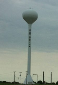
The Kaw Nation (or Kanza or Kansa) is a federally recognized Native American tribe in Oklahoma and parts of Kansas. It comes from the central Midwestern United States. It has also been called the "People of the South wind","Constitution of the Kaw Nation." ''Kaw Nation.'' 2011. Retrieved 30 April 2012. "People of water", ''Kansa'', ''Kaza'', ''Konza'', ''Conza'', ''Quans'', ''Kosa'', and ''Kasa''. Their tribal language is Kansa, classified as a .Unrau, William [...More Info...] [...Related Items...] OR: [Wikipedia] [Google] [Baidu] |


