|
Whitianga Aerodrome
Whitianga Aerodrome serves the town of Whitianga, New Zealand. The aerodrome is located 1.5 NM west of Whitianga on the eastern side of the Coromandel Peninsula in the North Island of New Zealand. The aerodrome is operated by the Mercury Bay Aero Club. The aerodrome is popular with model aircraft enthusiasts and glider pilots. Airlines and destinations Air Auckland bases an aircraft at Whitianga used for both scheduled services and sightseeing charters. See also * List of airports in New Zealand * List of airlines of New Zealand * Transport in New Zealand Transport in New Zealand, with its mountainous topography and a relatively small population mostly located near its long coastline, has always faced many challenges. Before Europeans arrived, Māori either walked or used watercraft on rivers o ... References Airports in New Zealand Thames-Coromandel District Transport buildings and structures in Waikato {{NewZealand-airport-stub ... [...More Info...] [...Related Items...] OR: [Wikipedia] [Google] [Baidu] |
Whitianga
Whitianga is a town on the Coromandel Peninsula, in the Waikato region of New Zealand's North Island. The town is located on Mercury Bay, on the northeastern coast of the peninsula. The town has a permanent population of as of making it the second-largest town on the Coromandel Peninsula behind Thames, New Zealand, Thames. Demographics Whitianga covers and had an estimated population of as of with a population density of people per km2. Whitianga North had a population of 5,493 at the 2018 New Zealand census, an increase of 1,086 people (24.6%) since the 2013 New Zealand census, 2013 census, and an increase of 1,689 people (44.4%) since the 2006 New Zealand census, 2006 census. There were 2,271 households, comprising 2,691 males and 2,805 females, giving a sex ratio of 0.96 males per female, with 882 people (16.1%) aged under 15 years, 729 (13.3%) aged 15 to 29, 2,310 (42.1%) aged 30 to 64, and 1,575 (28.7%) aged 65 or older. Ethnicities were 90.3% European/Pākehā, 1 ... [...More Info...] [...Related Items...] OR: [Wikipedia] [Google] [Baidu] |
Coromandel Peninsula
The Coromandel Peninsula ( mi, Te Tara-O-Te-Ika-A-Māui) on the North Island of New Zealand extends north from the western end of the Bay of Plenty, forming a natural barrier protecting the Hauraki Gulf and the Firth of Thames in the west from the Pacific Ocean to the east. It is wide at its broadest point. Almost its entire population lives on the narrow coastal strips fronting the Hauraki Gulf and the Bay of Plenty. In clear weather the peninsula is clearly visible from Auckland, the country's biggest city, which lies on the far shore of the Hauraki Gulf, to the west. The peninsula is part of the Thames-Coromandel District of the Waikato region. Origin of the name The Māori name for the Coromandel comes from the Māori legend of Māui and the Fish, in which the demigod uses his hook to catch a great fish from the depths of te Moana-Nui-a-Kiwa (The Pacific Ocean). ''Te Tara-O-Te-Ika-A-Māui'' means 'The spine of Māui's fish'. The spine can be understood to be the C ... [...More Info...] [...Related Items...] OR: [Wikipedia] [Google] [Baidu] |
North Island
The North Island, also officially named Te Ika-a-Māui, is one of the two main islands of New Zealand, separated from the larger but much less populous South Island by the Cook Strait. The island's area is , making it the world's 14th-largest island. The world's 28th-most-populous island, Te Ika-a-Māui has a population of accounting for approximately % of the total residents of New Zealand. Twelve main urban areas (half of them officially cities) are in the North Island. From north to south, they are Whangārei, Auckland, Hamilton, Tauranga, Rotorua, Gisborne, New Plymouth, Napier, Hastings, Whanganui, Palmerston North, and New Zealand's capital city Wellington, which is located at the south-west tip of the island. Naming and usage Although the island has been known as the North Island for many years, in 2009 the New Zealand Geographic Board found that, along with the South Island, the North Island had no official name. After a public consultation, the board officially ... [...More Info...] [...Related Items...] OR: [Wikipedia] [Google] [Baidu] |
New Zealand
New Zealand ( mi, Aotearoa ) is an island country in the southwestern Pacific Ocean. It consists of two main landmasses—the North Island () and the South Island ()—and over 700 smaller islands. It is the sixth-largest island country by area, covering . New Zealand is about east of Australia across the Tasman Sea and south of the islands of New Caledonia, Fiji, and Tonga. The country's varied topography and sharp mountain peaks, including the Southern Alps, owe much to tectonic uplift and volcanic eruptions. New Zealand's capital city is Wellington, and its most populous city is Auckland. The islands of New Zealand were the last large habitable land to be settled by humans. Between about 1280 and 1350, Polynesians began to settle in the islands and then developed a distinctive Māori culture. In 1642, the Dutch explorer Abel Tasman became the first European to sight and record New Zealand. In 1840, representatives of the United Kingdom and Māori chiefs ... [...More Info...] [...Related Items...] OR: [Wikipedia] [Google] [Baidu] |
Air Auckland
Air Auckland (formerly Flight Hauraki) is a small airline based at Ardmore Airport in New Zealand. The company is a fixed-wing and CAA part 135 air operator that offers flight services including regular flights to Whitianga and Great Barrier Island. History Flight Hauraki Limited was founded on 17 March 2008 as an associate company of MDR Aviation Ltd, a company specialising in aircraft leases and imports. In 2010 Flight Hauraki began operations with a charter and sightseeing service based out of the Salt Air terminal at North Shore Aerodrome. These services were operated by a fleet two Cessna 172s and Cessna 207, owned by MDR Aviation Ltd. The airline took over management of Air Discovery's Waiheke Island based services to Auckland Airport in March 2012, as well as their sightseeing operation and flights from Great Barrier Island to Auckland. Later in 2012, Flight Hauraki took over Salt Air's Kerikeri and Whangarei to North Shore 'Xpress' service, unique in its usage of th ... [...More Info...] [...Related Items...] OR: [Wikipedia] [Google] [Baidu] |
Ardmore Aerodrome
Ardmore Airport is an airport 3 nautical miles (5.5 km) southeast of Manurewa in Auckland, New Zealand. History Ardmore was constructed during World War II by USAAF forces stationed in Auckland and was intended to be used as a base for B-17 Flying Fortress bombers. Due to developments in the Pacific War it was never used for this purpose but was instead was used by the RNZAF, who operated Corsair fighters. RNZAF Auckland operations were consolidated at Whenuapai after World War II. From the post-war years until the mid-1970s the grounds were home to a teacher training unit and the Auckland University School of Engineering. New Zealand Grand Prix From 1954 until 1962 the aerodrome was home to the New Zealand Grand Prix with the circuit being approximately in length and utilising the two sealed runways operational at the time. In 1954 and 1955, about 70,000 spectators attended the event. Local authorities made the decision to open the facility to general aviation and t ... [...More Info...] [...Related Items...] OR: [Wikipedia] [Google] [Baidu] |
Great Barrier Aerodrome
Great Barrier Aerodrome is the major airfield on Great Barrier Island. It is a small, uncontrolled aerodrome at Claris on Great Barrier Island in the Hauraki Gulf off the North Island of New Zealand. Fuel is not available. The town of Claris is adjacent and there are rental car and bicycle hire services available at the airport. Landing fees were previously payable at Council offices, but are now billed direct to aircraft operators. Feral pigs are on the aerodrome sometimes. The aerodrome has two runways a grass strip and a marked asphalt runway which is 930m by 9m wide. Landing fees are charged by Auckland Transport and are invoiced to the registered owner of the aircraft as per the CAA register of aircraft. Landing fees are (inclusive of GST). $20 for private and $12 for scheduled commercial flights. Airlines and destinations See also * List of airports in New Zealand * List of airlines of New Zealand * Transport in New Zealand Transport in New Zealand, with ... [...More Info...] [...Related Items...] OR: [Wikipedia] [Google] [Baidu] |
Barrier Air
Barrier Air is a New Zealand airline that was established in 1983 by Jim Bergman as Great Barrier Airlines. The head office is located at the Domestic Terminal at Auckland Airport in Mangere, with additional offices in the terminal buildings at Great Barrier Aerodrome, Kaitaia Airport and North Shore Aerodrome. History The airline's initial fleet was one Cessna 172, one Cessna 206 and one vintage three-engine de Havilland Australia DHA-3 Drover. Bergman flew the first scheduled service to Great Barrier Island on 2 December 1983, departing from Ardmore Airport, three nautical miles southeast of Manurewa in Auckland. The company initially operated three flights a day from Ardmore to Auckland International and on to Great Barrier Aerodrome at Claris. In July 1984 the airline started flights to Okiwi Airfield on Great Barrier Island as well. The first Britten Norman Islander was introduced in December 1984. The first flights to Whangarei from its Auckland base began in August 1 ... [...More Info...] [...Related Items...] OR: [Wikipedia] [Google] [Baidu] |
Auckland Airport
Auckland Airport is the largest and busiest airport in New Zealand, with over 21 million passengers in the year ended March 2019. The airport is located near Māngere, a residential suburb, and Airport Oaks, a service hub suburb south of the Auckland city centre. It is both a domestic and international hub for Air New Zealand, and the New Zealand hub of Jetstar. The airport is one of New Zealand's most important infrastructure assets, providing thousands of jobs for the region. It handled 71 per cent of New Zealand's international air passenger arrivals and departures in 2000. It is one of only two commercial airports in New Zealand (the other being Christchurch) capable of handling Boeing 747 and Airbus A380 aircraft. The airport has a single runway, 05R/23L, which is Cat IIIb capable (at a reduced rate of movements) in the 23L direction. It has a capacity of about 45 flight movements per hour, and is currently the busiest single-runway airport in Oceania. In November 200 ... [...More Info...] [...Related Items...] OR: [Wikipedia] [Google] [Baidu] |
Sunair
Sunair is an airline based in New Zealand. It operates scheduled services in the North Island. Headquartered in Tauranga, the airline flies to Hamilton, Ardmore, Whangarei, Whitianga, Motiti Island and Great Barrier Island. (PDF) It also has charter and pilot training operations. Sunair has fifteen aircraft. History Sunair initially started as a commuter operator to Motiti Island in the Bay of Plenty with one aircraft. The airline has flown for over 30 years and has a safe accident free record. It operates approximately 4000 flights per year with a staff of 28. The wit ...[...More Info...] [...Related Items...] OR: [Wikipedia] [Google] [Baidu] |
Tauranga Airport
Tauranga Airport is an airport serving the city of Tauranga, New Zealand. It is located adjacent to Tauranga Harbour in the suburb of Mount Maunganui, approximately 3 km northeast of Tauranga CBD. The terminal is located to the north of the runway, on Jean Batten Drive, and consists of a two-storey building with four tarmac gates. Air New Zealand serves the airport through its subsidiaries Mount Cook Airline and Air Nelson, with flights to Auckland, Wellington and Christchurch. A further two regional airlines also operate to the airport, as well as scenic and charter flights, skydiving operations and general aviation. History In 1935, the Tauranga Aero Club leased land adjacent to Tauranga Harbour in Mount Maunganui to establish an aerodrome. Up until then, the only airfield serving the town was a runway on the eastern side of the Waikareao Estuary which was only usable during low tide, and it was deemed that a permanent facility was going to be necessary in order to ca ... [...More Info...] [...Related Items...] OR: [Wikipedia] [Google] [Baidu] |
List Of Airports In New Zealand ...
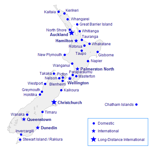
This is a list of airports in New Zealand, sorted by location. List Airport names shown in bold indicate the airport has scheduled passenger service on commercial airlines. The cities shown in bold are international. See also * Transport in New Zealand * List of busiest airports in New Zealand * List of airports by ICAO code: N#NZ - New Zealand * List of former Royal New Zealand Air Force stations References Great Circle Mapper- ICAO and IATA codes * * External links AIP New Zealand- airport and heliport charts {{Oceania in topic, List of airports in New Zealand Airports in New Zealand Airports New Zealand New Zealand ( mi, Aotearoa ) is an island country in the southwestern Pacific Ocean. It consists of two main landmasses—the North Island () and the South Island ()—and over 700 smaller islands. It is the sixth-largest island count ... [...More Info...] [...Related Items...] OR: [Wikipedia] [Google] [Baidu] |


