|
Whitchurch Lock
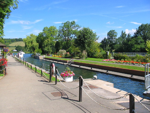
Whitchurch Lock is a lock and weir on the River Thames in England. It is a pound lock, built by the Thames Navigation Commissioners in 1787. It is on an island near the Oxfordshire village of Whitchurch-on-Thames and is accessible only by boat. The weir crosses the river to the Berkshire village of Pangbourne . History There was a flash lock recorded at Whitchurch in the 16th century. The sketch map shows the main dam, which was solid and rose to a height above normal high water level. Near the southern bank, there was a sluice (marked "E" on the sketch), which was wide, and was fitted with flood gates and overfall boards, to accommodate a drop of in the river level. The flash lock was in the centre, with a winch on the north bank to haul the barges through against the current. It was wide, which was the standard size for all flash locks below Abingdon. Near to the island was a "tumbling bay", an overfall weir with its crest just below normal low water level. It was a ... [...More Info...] [...Related Items...] OR: [Wikipedia] [Google] [Baidu] |
River Thames
The River Thames ( ), known alternatively in parts as the The Isis, River Isis, is a river that flows through southern England including London. At , it is the longest river entirely in England and the Longest rivers of the United Kingdom, second-longest in the United Kingdom, after the River Severn. The river rises at Thames Head in Gloucestershire, and flows into the North Sea near Tilbury, Essex and Gravesend, Kent, via the Thames Estuary. From the west it flows through Oxford (where it is sometimes called the Isis), Reading, Berkshire, Reading, Henley-on-Thames and Windsor, Berkshire, Windsor. The Thames also drains the whole of Greater London. In August 2022, the source of the river moved five miles to beyond Somerford Keynes due to the heatwave in July 2022. The lower reaches of the river are called the Tideway, derived from its long tidal reach up to Teddington Lock. Its tidal section includes most of its London stretch and has a rise and fall of . From Oxford to th ... [...More Info...] [...Related Items...] OR: [Wikipedia] [Google] [Baidu] |
Goring Lock
Goring Lock is a lock and weir situated on the River Thames in England at the Goring Gap in the Chiltern Hills. The lock is located on the Oxfordshire bank at Goring-On-Thames, with Streatley, Berkshire on the opposite side of the river. It is just upstream of Goring and Streatley Bridge. The lock was first built in 1787 by the Thames Navigation Commissioners The weir runs back to an island under the bridge and then another weir goes from there to the Streatley bank. History There was originally a weir and ferry here belonging to Goring Priory, which became the property of millers who kept a flash lock. A report in a newspaper of 1674 tells how 60 people drowned in the lock when the ferryman rowed too close to it. The pound lock was built in August 1787 from oak. Over several decades operation of the lock appears to have been shared with that of Cleeve Lock until 1869. Following this there were plans to build a lock-house, but this was not started until 1879.Fred. S. Thack ... [...More Info...] [...Related Items...] OR: [Wikipedia] [Google] [Baidu] |
Rowing On The River Thames
The Thames is one of the main rowing rivers in Europe. Dorney Lake between Slough and Windsor, Berkshire is an international Cup, standard-distance rowing lake besides the Thames, and hosts the three main annual entry regattas for Henley: still named Marlow (International), Wallingford and Metropolitan. Other rowing lakes near the Thames are the Redgrave Pinsent Rowing Lake between Reading and Henley used by the Great Britain squad and Royal Albert Dock near North Woolwich, London. History Rowing races on the River Thames have been documented as early as 1725, and the Thames was the venue for the 1908 London Olympics rowing races. Contemporary events, groups and modern history The sport and recreational/touring rowing takes place on the Tideway and on the 45 separate lock reaches on the non-tidal section. The river hosts a televised succession of races on which bets are placed – traditionally named The Boat Race and for some decades a men-only event – it is now ... [...More Info...] [...Related Items...] OR: [Wikipedia] [Google] [Baidu] |
Locks On The River Thames
The English River Thames is navigable from Cricklade (for very small, shallow boats) or Lechlade (for larger boats) to the sea, and this part of the river falls 71 meters (234 feet). There are 45 locks on the river, each with one or more adjacent weirs. These lock and weir combinations are used for controlling the flow of water down the river, most notably when there is a risk of flooding, and provide for navigation above the tideway. History From ancient times there were many obstructions across the Thames, for fish-pounds and millers' weirs. They are referred to by Asserius Menevensis in the ninth century and Magna Carta (1215) states that "weirs, for the time to come, shall be demolished in the Thames and Medway, except on the sea coast." It appears this never happened. In the Middle Ages, the fall on the river in its middle and upper sections was used to drive watermills for the production of flour and paper and various other purposes such as metal-beating. This involv ... [...More Info...] [...Related Items...] OR: [Wikipedia] [Google] [Baidu] |
Thames Path
The Thames Path is a National Trail following the River Thames from its source near Kemble, Gloucestershire, Kemble in Gloucestershire to the Woolwich foot tunnel, south east London. It is about long. A path was first proposed in 1948 but it only opened in 1996. The Thames Path's entire length can be walked, and a few parts can be cycled. Some parts of the Thames Path, particularly west of Oxford, are subject to flooding during the winter. The river is also Tide, tidal downstream from Teddington Lock and the lower parts of these paths may be underwater if there is a particularly high tide, although the Thames Barrier protects London from catastrophic flooding. The Thames Path uses the river towpath between Inglesham and Putney and available paths elsewhere. Historically, towpath traffic crossed the river using many ferry, ferries, but few of these crossings exist now and some diversion from the towpath is necessary. Description and access to the river The general aim of the pa ... [...More Info...] [...Related Items...] OR: [Wikipedia] [Google] [Baidu] |
Pangbourne College
Pangbourne College is a co-educational independent day and boarding school located in the civil parish of Pangbourne, in the English county of Berkshire. It is set in 230 acres, on a hill south-west of the village, in an Area of Outstanding Natural Beauty. The college was founded by Sir Thomas Lane Devitt Bt. in 1917 as The Nautical College, Pangbourne with the purpose of training boys to become Merchant Navy officers. It became "Pangbourne College" in 1969 and while conforming to the general lines of a British independent boarding school, retains a distinctly nautical flavour; the pupils wear naval uniform. History The college was founded by Sir Thomas Lane Devitt, 1st Baronet, in 1917 as "The Nautical College, Pangbourne", on the site originally occupied by Clayesmore School, now located in Dorset. The Nautical College's purpose was to prepare boys to become officers in the Merchant Navy through his shipping company Devitt and Moore, although both he, and later his son, Si ... [...More Info...] [...Related Items...] OR: [Wikipedia] [Google] [Baidu] |
Goring And Streatley Bridge
Goring and Streatley Bridge is a road bridge across the River Thames in England. The bridge links the twin villages of Goring-on-Thames, Oxfordshire, and Streatley, Berkshire, and is adjacent to Goring Lock. The present bridge was built in 1923, and is in two parts: The western bridge is from Streatley to an island in the river (overlooking ''The Swan'' hotel, once owned by Danny La Rue); The eastern bridge is from the island to Goring and overlooks Goring Lock. The bridge consists of timber struts supporting a metal roadway. Both the Thames Path and The Ridgeway cross the Thames on this bridge. A bridge was first built here in 1837 being a flat timber bridge of beams on posts. Prior to this there was a ferry although occasionally people would ride across, even driving in a one-horse chaise. In 1674 the ferry turned over in the weir pool with the loss of sixty lives.Fred. S. Thacker ''The Thames Highway: Volume II Locks and Weirs'' 1920 - republished 1968 David & Charles In the ... [...More Info...] [...Related Items...] OR: [Wikipedia] [Google] [Baidu] |
Streatley, Berkshire
Streatley is a village and civil parish on the River Thames in Berkshire, England. The village faces Goring-on-Thames. The two places share in their shops, services, leisure, sports and much of their transport. Across the river is railway station and the village cluster adjoins a lock and weir. The west of the village is a mixture of agriculture and woodland plus a golf course. The village has a riverside hotel. Much of Streatley is at steeply varying elevations, ranging from 51m AOD to 185m at Streatley Warren, a hilltop point on its western border forming the eastern end of the Berkshire Downs. This Area of Outstanding Natural Beauty is topped by the 87-mile The Ridgeway path, which crosses the Thames at Goring and Streatley Bridge. Location Streatley is centred north-west of Reading and south of Oxford. Its developed area occupies half of the narrow Goring Gap on the River Thames and is directly across the river from the Oxfordshire village of Goring-on-Thames. The two ... [...More Info...] [...Related Items...] OR: [Wikipedia] [Google] [Baidu] |
Basildon Park
Basildon Park is a country house situated 2 miles (3 kilometres) south of Goring-on-Thames and Streatley in Berkshire, between the villages of Upper Basildon and Lower Basildon. It is owned by the National Trust and is a Grade I listed building. The house was built between 1776 and 1783 for Sir Francis Sykes and designed by John Carr in the Palladian style at a time when Palladianism was giving way to the newly fashionable neoclassicism. Thus, the interiors are in a neoclassical "Adamesque" style. Never fully completed, the house passed through a succession of owners. In 1910 it was standing empty and in 1914, it was requisitioned by the British Government as an army convalescent hospital. It was again sold in 1928 and quickly sold again. In 1929, following a failed attempt to dismantle and rebuild the house in the US, it was stripped of many of its fixtures and fittings and all but abandoned. During World War II, the house was again requisitioned and served as a barracks, ... [...More Info...] [...Related Items...] OR: [Wikipedia] [Google] [Baidu] |
Beale Park
Beale Wildlife Park is situated by the River Thames, between the villages of Pangbourne and Lower Basildon in Berkshire, England. It has three main areas of attraction: collections of small exotic animals, farm animals and birds; landscaped gardens and woodlands; and children's play areas. In 1956, Beale Park was formed by Gilbert Beale who decided to give the Thames-side park land to ‘the people’ by converting it from private farmland into a non-profit making, charitable trust. In those days it was little more than a track and a couple of ponds. Attractions Over recent years, the park has expanded to accommodate a wide variety of visitors, especially the youngest ones. The park has recently built a Roplay area, a pets area, sand pits, paddling pools, Little Tikes Play Area, and the Beale Railway, a section of narrow gauge railway on which is run a diesel locomotive, "Sir Humphrey Davy"; and previously a steam locomotive, "John Remmy", each capable of pulling 5 carriages ... [...More Info...] [...Related Items...] OR: [Wikipedia] [Google] [Baidu] |
Goring-on-Thames
Goring-on-Thames (or Goring) is a village and civil parish on the River Thames in South Oxfordshire, England, about south of Wallingford and northwest of Reading. It had a population of 3,187 in the 2011 census, put at 3,335 in 2019. Goring & Streatley railway station is on the main Oxford–London line. Most land is farmland, with woodland on the Goring Gap outcrop of the Chiltern Hills. Its riverside plain encloses the residential area, including a high street with shops, pubs and restaurants. Nearby are the village churches – one dedicated to St Thomas Becket has a nave built within 50 years of the saint's death, in the early 13th century, along with a later bell tower. Goring faces the smaller Streatley across the Thames. The two are linked by Goring and Streatley Bridge. Geography Goring is on the left bank of the River Thames in the Goring Gap between the Berkshire Downs and Chiltern Hills, about north-west of Reading and south of Oxford. Across the river is the B ... [...More Info...] [...Related Items...] OR: [Wikipedia] [Google] [Baidu] |


