|
West Siberian Petroleum Basin
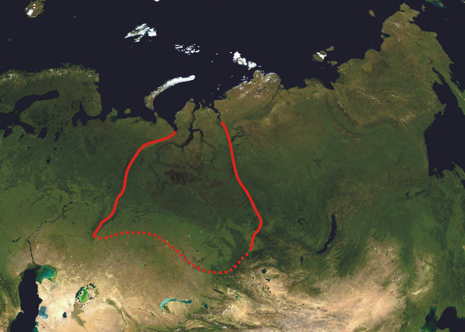
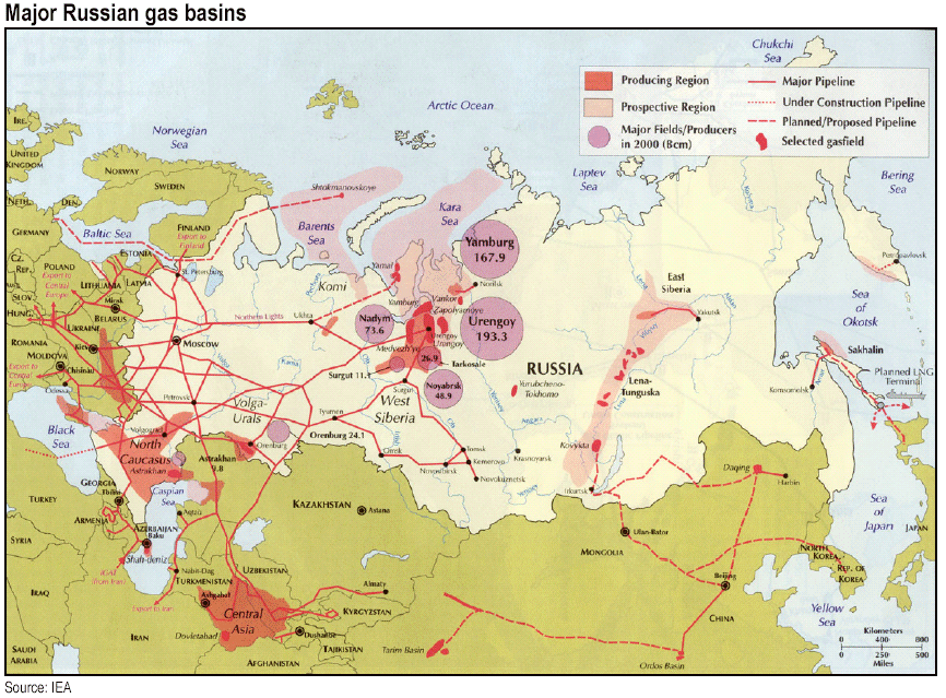
The West Siberian petroleum basin (also known as the West Siberian hydrocarbon province or Western Siberian oil basin) is the largest hydrocarbon (petroleum and natural gas) basin in the world covering an area of about 2.2 million km², and is also the largest oil and gas producing region in Russia. Geographically it corresponds to the West Siberian plain. From continental West Siberia, it extends into the Kara Sea as the East-Prinovozemelsky field. Beneath lie remnants of the Siberian traps, thought to be responsible for the Great Dying 250 million years ago. History Gas was discovered in 1953 in Upper Jurassic sandstones and limestones, within the Berezov Field. Then in 1960, oil was discovered in the Upper Jurassic 400 km south, in the Trekhozer Field. A Neocomian oil discovery followed in 1961, in the Middle Ob Region, followed by several giant and large fields, including the Samotlor Field. Gas was discovered in Cenomanian sandstones in 1962 within the Taz Fi ... [...More Info...] [...Related Items...] OR: [Wikipedia] [Google] [Baidu] |
Neocomian
In geology, Neocomian was a name given to the lowest stage of the Cretaceous system. It is generally considered to encompass the interval now covered by the Berriasian, Valanginian and Hauterivian, from approximately 145 to 130 Ma. It was introduced by Jules Thurmann in 1835 on account of the development of these rocks at Neuchâtel (Neocomum), Switzerland. It has been employed in more than one sense. In the type area the rocks have been divided into two sub-stages, a lower, Valanginian (from Valengin, Pierre Jean Édouard Desor, 1854) and an upper, Hauterivian (from Hauterive, Eugène Renevier, 1874); there is also another local sub-stage, the infra-Valanginian or Berriasian (from Berrias, Henri Coquand, 1876). These three sub-stages constitute the Neocomian in its restricted sense. Adolf von Koenen and other German geologists extend the use of the term to include the whole of the Lower Cretaceous up to the top of the Gault or Albian. Eugène Renevier Eugène Renevier (26 March ... [...More Info...] [...Related Items...] OR: [Wikipedia] [Google] [Baidu] |
Yamal Peninsula
The Yamal Peninsula (russian: полуостров Ямал, poluostrov Yamal) is located in the Yamalo-Nenets Autonomous Okrug of northwest Siberia, Russia. It extends roughly 700 km (435 mi) and is bordered principally by the Kara Sea, Baydaratskaya Bay on the west, and by the Gulf of Ob on the east. At the northern end of this peninsula lie the Malygina Strait and, beyond it, Bely Island. Across the river lies the Gyda Peninsula. In the language of its indigenous inhabitants, the Nenets, "Yamal" means "End of the Land". The Yamal peninsula is inhabited by a multitude of migratory bird species. The well-preserved remains of Lyuba, a 37,000-year-old mammoth calf, were found by a reindeer herder on the peninsula in the summer of 2007. The animal was female and was determined to be one month old at the time of death. Geography The peninsula consists mostly of permafrost ground and there are numerous lakes of thermokarst origin, the biggest of which are Neito and ... [...More Info...] [...Related Items...] OR: [Wikipedia] [Google] [Baidu] |
Yamal Project
Yamal project, also referred to as Yamal megaproject, is a long-term plan to exploit and bring to the markets the vast natural gas reserves in the Yamal Peninsula, Russia. Administratively, the project is located in the Yamalo-Nenets Autonomous Okrug. The project is developed by Gazprom. History Preparations for the Yamal's development started in the 1990s. According to the original plans, drilling work on the Bovanenkovo field was to have started in 1997. In January 2002, Gazprom identified the Yamal Peninsula as a region of Gazprom's strategic interest. Preparatory works started in 2007 with the construction of auxiliary infrastructures, such as staff buildings and transport facilities. In July 2008 Gazprom launched the construction of the Bovanenkovo–Ukhta gas trunkline at the submerged crossing via the Baydaratskaya Bay. The project was officially inaugurated on 3 December 2008. As of 2020, Yamal produces over 20% of Russia's natural gas, which is expected to increase to 4 ... [...More Info...] [...Related Items...] OR: [Wikipedia] [Google] [Baidu] |
Gazprom
PJSC Gazprom ( rus, Газпром, , ɡɐzˈprom) is a Russian majority state-owned multinational energy corporation headquartered in the Lakhta Center in Saint Petersburg. As of 2019, with sales over $120 billion, it was ranked as the largest publicly listed natural gas company in the world and the largest company in Russia by revenue. In the 2020 ''Forbes'' Global 2000, Gazprom was ranked as the 32nd largest public company in the world. The Gazprom name is a contraction of the Russian words ''gazovaya promyshlennost'' (, gas industry). In January 2022, Gazprom displaced Sberbank from the first place in the list of the largest companies in Russia by market capitalization. Gazprom is vertically integrated and is active in every area of the gas industry, including exploration and production, refining, transport, distribution and marketing, and power generation. In 2018, Gazprom produced twelve percent of the global output of natural gas, producing 497.6 billion cubic meters ... [...More Info...] [...Related Items...] OR: [Wikipedia] [Google] [Baidu] |
Rusanovskoye Gas Field
The Rusanovskoye gas field is a natural gas field located in the Yamalo-Nenets Autonomous Okrug. It was discovered around 1980 and is not yet in production. See also *West Siberian petroleum basin The West Siberian petroleum basin (also known as the West Siberian hydrocarbon province or Western Siberian oil basin) is the largest hydrocarbon (petroleum and natural gas) basin in the world covering an area of about 2.2 million km², and is al ... References Natural gas fields in Russia Natural gas fields in the Soviet Union {{Russia-geo-stub ... [...More Info...] [...Related Items...] OR: [Wikipedia] [Google] [Baidu] |
Formation (geology)
A geological formation, or simply formation, is a body of rock having a consistent set of physical characteristics ( lithology) that distinguishes it from adjacent bodies of rock, and which occupies a particular position in the layers of rock exposed in a geographical region (the stratigraphic column). It is the fundamental unit of lithostratigraphy, the study of strata or rock layers. A formation must be large enough that it can be mapped at the surface or traced in the subsurface. Formations are otherwise not defined by the thickness of their rock strata, which can vary widely. They are usually, but not universally, tabular in form. They may consist of a single lithology (rock type), or of alternating beds of two or more lithologies, or even a heterogeneous mixture of lithologies, so long as this distinguishes them from adjacent bodies of rock. The concept of a geologic formation goes back to the beginnings of modern scientific geology. The term was used by Abraham Gottlob Wer ... [...More Info...] [...Related Items...] OR: [Wikipedia] [Google] [Baidu] |
Middle Jurassic
The Middle Jurassic is the second epoch of the Jurassic Period. It lasted from about 174.1 to 163.5 million years ago. Fossils of land-dwelling animals, such as dinosaurs, from the Middle Jurassic are relatively rare, but geological formations containing land animal fossils include the Forest Marble Formation in England, the Kilmaluag Formation in Scotland,British Geological Survey. 2011Stratigraphic framework for the Middle Jurassic strata of Great Britain and the adjoining continental shelf: research report RR/11/06 British Geological Survey, Keyworth, Nottingham. the Daohugou Beds in China, the Itat Formation in Russia, and the Isalo III Formation of western Madagascar. Paleogeography During the Middle Jurassic Epoch, Pangaea began to separate into Laurasia and Gondwana, and the Atlantic Ocean formed. Eastern Laurasia was tectonically active as the Cimmerian plate continued to collide with Laurasia's southern coast, completely closing the Paleo-Tethys Ocean. A subduction zone ... [...More Info...] [...Related Items...] OR: [Wikipedia] [Google] [Baidu] |
Urengoy Field
The Urengoy gas field in the northern West Siberia Basin is the world's second largest natural gas field after South Pars / North Dome Gas-Condensate field. The gas field has over ten trillion cubic meters (1013 m³) in total deposits. It lies in Yamalo-Nenets Autonomous Okrug in Tyumen Oblast of Russia, just south of the Arctic circle and named after the settlement of Urengoy. The gas field is serviced by the town of Novy Urengoy, founded in 1973. History Urengoy gas field was discovered in June 1966. The first drilling hole hit gas on 6 July 1966 and the field started production in 1978. On 25 February 1981, Urengoy extracted its first one hundred billion cubic meters (1011 m³) of natural gas Natural gas (also called fossil gas or simply gas) is a naturally occurring mixture of gaseous hydrocarbons consisting primarily of methane in addition to various smaller amounts of other higher alkanes. Low levels of trace gases like carbo .... From January 1984, ... [...More Info...] [...Related Items...] OR: [Wikipedia] [Google] [Baidu] |
Medvezhye Gas Field
The Medvezhye gas field is a natural gas field located in the Yamalo-Nenets Autonomous Okrug. It was discovered in 1967 and developed by Gazprom. It began production in 1972 and produces natural gas and condensates. The total proven reserves Proven reserves (also called measured reserves, 1P, and reserves) is a measure of fossil fuel energy reserves, such as oil reserves, natural gas reserves, and coal reserves. It is defined as the " antity of energy sources estimated with reasona ... of the Medvezhye gas field are around 83 trillion cubic feet (2370 km³), and production is slated to be around 4.89 Billion cubic feet/day (140×105m³) in 2013. References Natural gas fields in Russia Natural gas fields in the Soviet Union {{Russia-geo-stub ... [...More Info...] [...Related Items...] OR: [Wikipedia] [Google] [Baidu] |
Aptian
The Aptian is an age in the geologic timescale or a stage in the stratigraphic column. It is a subdivision of the Early or Lower Cretaceous Epoch or Series and encompasses the time from 121.4 ± 1.0 Ma to 113.0 ± 1.0 Ma (million years ago), approximately. The Aptian succeeds the Barremian and precedes the Albian, all part of the Lower/Early Cretaceous. The Aptian partly overlaps the upper part of the Western European Urgonian Stage. The Selli Event, also known as OAE1a, was one of two oceanic anoxic events in the Cretaceous Period, which occurred around 120 Ma and lasted approximately 1 to 1.3 million years. The Aptian extinction was a minor extinction event hypothesized to have occurred around 116 to 117 Ma.Archangelsky, Sergio.The Ticó Flora (Patagonia) and the Aptian Extinction Event" ''Acta Paleobotanica'' 41(2), 2001, pp. 115-22. Stratigraphic definitions The Aptian was named after the small city of Apt in the Provence region of France, which is also known for its cry ... [...More Info...] [...Related Items...] OR: [Wikipedia] [Google] [Baidu] |
Cenomanian
The Cenomanian is, in the ICS' geological timescale, the oldest or earliest age of the Late Cretaceous Epoch or the lowest stage of the Upper Cretaceous Series. An age is a unit of geochronology; it is a unit of time; the stage is a unit in the stratigraphic column deposited during the corresponding age. Both age and stage bear the same name. As a unit of geologic time measure, the Cenomanian Age spans the time between 100.5 and 93.9 million years ago (Mya). In the geologic timescale, it is preceded by the Albian and is followed by the Turonian. The Upper Cenomanian starts around at 95 Mya. The Cenomanian is coeval with the Woodbinian of the regional timescale of the Gulf of Mexico and the early part of the Eaglefordian of the regional timescale of the East Coast of the United States. At the end of the Cenomanian, an anoxic event took place, called the Cenomanian-Turonian boundary event or the "Bonarelli event", that is associated with a minor extinction event for marine spec ... [...More Info...] [...Related Items...] OR: [Wikipedia] [Google] [Baidu] |


