|
Waterville, Carleton County, New Brunswick
Waterville is a Canadian rural community in Carleton County, New Brunswick on Route 590. History In 1866, Waterville was a town mostly devoted to farming and lumber, with a population of around 60 families. By 1871 the town had a population of 500, though this had shrunk down to 150 by 1898. Geography Waterville is a community located in Wakefield Parish in Carleton County, New Brunswick, Canada. It is located on Route 590. There are three separate settlements: Central Waterville, Upper Waterville, and Lower Waterville. At one time there were also two additional settlements named Rockwell and Walton. Notable people See also *List of communities in New Brunswick This is a list of communities in New Brunswick, a province in Canada. For the purposes of this list, a community is defined as either an incorporated municipality, an Indian reserve, or an unincorporated community inside or outside a municipalit ... References Communities in Carleton County, New Brunswick [...More Info...] [...Related Items...] OR: [Wikipedia] [Google] [Baidu] |
Carleton County, New Brunswick
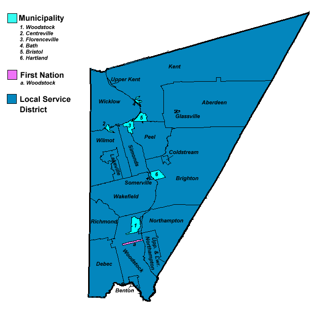
Carleton County (2016 population 26,220) is located in west-central New Brunswick, Canada. The western border is Aroostook County, Maine, Aroostook County, Maine, the northern border is Victoria County, New Brunswick, Victoria County, and the southeastern border is York County, New Brunswick, York County from which it was formed in 1831. The Saint John River (New Brunswick), Saint John River bisects the western section of the county. The Southwest Miramichi River flows through the eastern section of the county. Potato farming is a major industry. The scenic town of Hartland, New Brunswick, Hartland is home to the longest covered bridge in the world. Transportation Major Highways * * * * * * * * * * * * * * * * * * * * Census subdivisions List of communities in New Brunswick, Communities There are five incorporated municipalities within Carleton County (listed by 2016 population): First Nations There is one First Nations reserve in Carleton County, the Woodstock_First_Na ... [...More Info...] [...Related Items...] OR: [Wikipedia] [Google] [Baidu] |
New Brunswick
New Brunswick (french: Nouveau-Brunswick, , locally ) is one of the thirteen provinces and territories of Canada. It is one of the three Maritime provinces and one of the four Atlantic provinces. It is the only province with both English and French as its official languages. New Brunswick is bordered by Quebec to the north, Nova Scotia to the east, the Gulf of Saint Lawrence to the northeast, the Bay of Fundy to the southeast, and the U.S. state of Maine to the west. New Brunswick is about 83% forested and its northern half is occupied by the Appalachians. The province's climate is continental with snowy winters and temperate summers. New Brunswick has a surface area of and 775,610 inhabitants (2021 census). Atypically for Canada, only about half of the population lives in urban areas. New Brunswick's largest cities are Moncton and Saint John, while its capital is Fredericton. In 1969, New Brunswick passed the Official Languages Act which began recognizing French as an ... [...More Info...] [...Related Items...] OR: [Wikipedia] [Google] [Baidu] |
New Brunswick Route 590
{{NewBrunswick-road-stub ...
Route 590 is an long north–south secondary highway in the eastern portion of New Brunswick, Canada. The route starts at Route 130 north of Waterville east of Exit 172 of the Trans Canada Highway. The road travels south through Waterville and Lower Waterville, along a former Trans-Canada alignment, before continuing southeast through a mostly agricultural area to end at Route 560 in Jacksonville. History See also * * References 590 590 __NOTOC__ Year 590 ( DXC) was a common year starting on Sunday (link will display the full calendar) of the Julian calendar. The denomination 590 for this year has been used since the early medieval period, when the Anno Domini calendar era bec ... [...More Info...] [...Related Items...] OR: [Wikipedia] [Google] [Baidu] |
List Of Communities In New Brunswick
This is a list of communities in New Brunswick, a province in Canada. For the purposes of this list, a community is defined as either an incorporated municipality, an Indian reserve, or an unincorporated community inside or outside a municipality. Cities New Brunswick has eight cities. Indian reserves First Nations Parishes New Brunswick has 152 parishes, of which 150 are recognized as census subdivisions by Statistics Canada. Local service districts Rural communities New Brunswick has seven rural communities. Towns and villages New Brunswick has 27 towns and 66 villages. Neighbourhoods Local service districts Other communities and settlements This is a list of communities and settlements in New Brunswick. A–B ; A * Aboujagne * Acadie * Acadie Siding * Acadieville * Adams Gulch * Adamsville * Albert Mines * Albrights Corner * Alderwood * Aldouane * Allainville * Allardville * Allison * Ammon * Anagance * A ... [...More Info...] [...Related Items...] OR: [Wikipedia] [Google] [Baidu] |

