|
Wallog
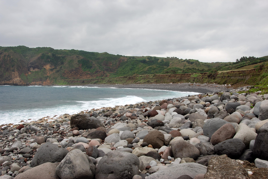
Wallog is a beach on the coast of Cardigan Bay north of Aberystwyth between Clarach Bay and Borth in the county of Ceredigion, Mid-Wales. A shingle spit named Sarn Gynfelyn originates from here. An old disused lime kiln is located at the end of this moraine. The lime was shipped into this spot, treated and then spread over the lands of the Wallog estate. Wallog lies on the route of the Ceredigion Coast Path The Ceredigion Coast Path ( cy, Llwybr Arfordir Ceredigion) is a waymarked long distance footpath in the United Kingdom, on the coast of Ceredigion, Wales. It is in length, running along the coast of Cardigan Bay from Cardigan to .... Although there is no direct road to Wallog beach, it can be reached by a public footpath, which follows a green lane to the beach, where seals and other wildlife are abundant. References {{Ceredigion Beaches of Ceredigion Coast of Ceredigion Lime kilns in the United Kingdom ... [...More Info...] [...Related Items...] OR: [Wikipedia] [Google] [Baidu] |
Sarn Gynfelyn
Sarn Gynfelyn is a shingle spit on the coast of Cardigan Bay, in the county of Ceredigion, Mid-Wales, in the United Kingdom. It is located at Wallog, a few kilometres north of Llangorwen, close to Clarach Bay, south of Borth and north of the town of Aberystwyth. Similar landform examples are found at several points along the Cardigan Bay coast, known as ''sarnau''. These long subtidal banks are thought to have originated as glacial moraines. In legend These protruding banks resemble man-made causeways and have long been part of the centuries-old legend of Cantre'r Gwaelod, a fabled sunken kingdom which was lost beneath the waters of Cardigan Bay. According to legend, Sarn Gynfelyn was one of the causeways leading to the lost land. The legend of Cantre'r Gwaelod is comparable to the deluge myth found in nearly every ancient culture, and it has been likened to the story of Atlantis. In a 2006 episode of the BBC television documentary ''Coast'', presenter Neil Oliver visited ... [...More Info...] [...Related Items...] OR: [Wikipedia] [Google] [Baidu] |
Shingle Beach
A shingle beach (also referred to as rocky beach or pebble beach) is a beach which is armoured with pebbles or small- to medium-sized cobbles (as opposed to fine sand). Typically, the stone composition may grade from characteristic sizes ranging from diameter. While this beach landform is most commonly found in Europe, examples are found in Bahrain, North America, and a number of other world regions, such as the west coast of New Zealand's South Island, where they are associated with the shingle fans of braided rivers. Though created at shorelines, post-glacial rebound can raise shingle beaches as high as above sea level, as on the High Coast in Sweden. The ecosystems formed by this unique association of rock and sand allow colonization by a variety of rare and endangered species. Formation Shingle beaches are typically steep, because the waves easily flow through the coarse, porous surface of the beach, decreasing the effect of backwash erosion and increasing the formati ... [...More Info...] [...Related Items...] OR: [Wikipedia] [Google] [Baidu] |
Beaches Of Ceredigion
A beach is a landform alongside a body of water which consists of loose particles. The particles composing a beach are typically made from Rock (geology), rock, such as sand, gravel, shingle beach, shingle, pebbles, etc., or biological sources, such as mollusc shells or coralline algae. Sediments settle in different densities and structures, depending on the local wave action and weather, creating different textures, colors and gradients or layers of material. Though some beaches form on inland freshwater locations such as lakes and rivers, most beaches are in coastal areas where wind wave, wave or Ocean current, current action deposition (geology), deposits and reworks sediments. Coastal erosion, Erosion and changing of beach geologies happens through natural processes, like wave action and Extreme weather, extreme weather events. Where wind conditions are correct, beaches can be backed by coastal dunes which offer protection and regeneration for the beach. However, the ... [...More Info...] [...Related Items...] OR: [Wikipedia] [Google] [Baidu] |
Ceredigion Coast Path
The Ceredigion Coast Path ( cy, Llwybr Arfordir Ceredigion) is a waymarked long distance footpath in the United Kingdom, on the coast of Ceredigion, Wales. It is in length, running along the coast of Cardigan Bay from Cardigan to Ynyslas The path forms one section of the Wales Coast Path, an long-distance walking route around the whole coast of Wales from Chepstow to Queensferry, opened in 2012.All-Wales Coast Path Nears Completion . ''BBC News Wales''. BBC. 17 October 2011. Retrieved 2 January 2012. Background The Ceredigion Coast Path project was funded under the EU's |
Moraine
A moraine is any accumulation of unconsolidated debris (regolith and rock), sometimes referred to as glacial till, that occurs in both currently and formerly glaciated regions, and that has been previously carried along by a glacier or ice sheet. It may consist of partly rounded particles ranging in size from boulders (in which case it is often referred to as boulder clay) down to gravel and sand, in a groundmass of finely-divided clayey material sometimes called glacial flour. Lateral moraines are those formed at the side of the ice flow, and terminal moraines were formed at the foot, marking the maximum advance of the glacier. Other types of moraine include ground moraines (till-covered areas forming sheets on flat or irregular topography) and medial moraines (moraines formed where two glaciers meet). Etymology The word ''moraine'' is borrowed from French , which in turn is derived from the Savoyard Italian ("mound of earth"). ''Morena'' in this case was derived from ProvenĂ ... [...More Info...] [...Related Items...] OR: [Wikipedia] [Google] [Baidu] |
Lime Kiln
A lime kiln is a kiln used for the calcination of limestone (calcium carbonate) to produce the form of lime (material), lime called quicklime (calcium oxide). The chemical equation for this chemical reaction, reaction is :Calcium carbonate, CaCO3 + heat → Calcium oxide, CaO + Carbon dioxide, CO2 This reaction can take place at anywhere above 840 °C (1544 °F), but is generally considered to occur at 900 °C(1655 °F) (at which temperature the partial pressure of CO2 is 1 atmosphere (unit), atmosphere), but a temperature around 1000 °C (1832 °F) (at which temperature the partial pressure of CO2 is 3.8 atmospheres) is usually used to make the reaction proceed quickly.Parkes, G.D. and Mellor, J.W. (1939). ''Mellor's Modern Inorganic Chemistry'' London: Longmans, Green and Co. Excessive temperature is avoided because it produces unreactive, "dead-burned" lime. Slaked lime (calcium hydroxide) can be formed by mixing quicklime with water. Early li ... [...More Info...] [...Related Items...] OR: [Wikipedia] [Google] [Baidu] |
Spit (landform)
A spit or sandspit is a deposition bar or beach landform off coasts or lake shores. It develops in places where re-entrance occurs, such as at a cove's headlands, by the process of longshore drift by longshore currents. The drift occurs due to waves meeting the beach at an oblique angle, moving sediment down the beach in a zigzag pattern. This is complemented by longshore currents, which further transport sediment through the water alongside the beach. These currents are caused by the same waves that cause the drift. Hydrology and geology Where the direction of the shore inland ''re-enters'', or changes direction, for example at a headland, the longshore current spreads out or dissipates. No longer able to carry the full load, much of the sediment is dropped. This is called deposition. This submerged bar of sediment allows longshore drift or littoral drift to continue to transport sediment in the direction the waves are breaking, forming an above-water spit. Without the co ... [...More Info...] [...Related Items...] OR: [Wikipedia] [Google] [Baidu] |
Wales
Wales ( cy, Cymru ) is a Countries of the United Kingdom, country that is part of the United Kingdom. It is bordered by England to the Wales–England border, east, the Irish Sea to the north and west, the Celtic Sea to the south west and the Bristol Channel to the south. It had a population in 2021 of 3,107,500 and has a total area of . Wales has over of coastline and is largely mountainous with its higher peaks in the north and central areas, including Snowdon (), its highest summit. The country lies within the Temperateness, north temperate zone and has a changeable, maritime climate. The capital and largest city is Cardiff. Welsh national identity emerged among the Celtic Britons after the Roman withdrawal from Britain in the 5th century, and Wales was formed as a Kingdom of Wales, kingdom under Gruffydd ap Llywelyn in 1055. Wales is regarded as one of the Celtic nations. The Conquest of Wales by Edward I, conquest of Wales by Edward I of England was completed by 1283, th ... [...More Info...] [...Related Items...] OR: [Wikipedia] [Google] [Baidu] |
East Of England
The East of England is one of the nine official regions of England. This region was created in 1994 and was adopted for statistics purposes from 1999. It includes the ceremonial counties of Bedfordshire, Cambridgeshire, Essex, Hertfordshire, Norfolk and Suffolk. Essex has the highest population in the region. The population of the East of England region in 2018 was 6.24 million. Bedford, Luton, Basildon, Peterborough, Southend-on-Sea, Norwich, Ipswich, Colchester, Chelmsford and Cambridge are the region's most populous settlements. The southern part of the region lies in the London commuter belt. Geography The East of England region has the lowest elevation range in the UK. Twenty percent of the region is below mean sea level, most of this in North Cambridgeshire, Norfolk and on the Essex Coast. Most of the remaining area is of low elevation, with extensive glacial deposits. The Fens, a large area of reclaimed marshland, are mostly in North Cambridgeshire. The Fens includ ... [...More Info...] [...Related Items...] OR: [Wikipedia] [Google] [Baidu] |
County
A county is a geographic region of a country used for administrative or other purposesChambers Dictionary, L. Brookes (ed.), 2005, Chambers Harrap Publishers Ltd, Edinburgh in certain modern nations. The term is derived from the Old French denoting a jurisdiction under the sovereignty of a count (earl) or a viscount.The Oxford Dictionary of English Etymology, C. W. Onions (Ed.), 1966, Oxford University Press Literal equivalents in other languages, derived from the equivalent of "count", are now seldom used officially, including , , , , , , , and ''zhupa'' in Slavic languages; terms equivalent to commune/community are now often instead used. When the Normans conquered England, they brought the term with them. The Saxons had already established the districts that became the historic counties of England, calling them shires;Vision of Britai– Type details for ancient county. Retrieved 31 March 2012 many county names derive from the name of the county town (county seat) with t ... [...More Info...] [...Related Items...] OR: [Wikipedia] [Google] [Baidu] |
Borth
Borth ( cy, Y Borth) is a village and seaside resort in Ceredigion, Mid Wales, 7 miles (11 km) north of Aberystwyth on the Ceredigion Coast Path. The community includes the settlement of Ynyslas. The population was 1,399 in 2011. From being largely Welsh-speaking, the village has become anglicised: over 54 per cent of its residents were born in England. According to both the 1991 and 2001 censuses, 43 per cent of the residents of Borth were primarily Welsh-speakers. Features and history Borth's sandy beach has helped to promote it as a seaside resort. There is a youth hostel in the village, and caravan and camping sites nearby. There is an ancient submerged forest visible at low tide along the beach, where stumps of oak, pine, birch, willow and hazel (preserved by the acid anaerobic conditions in the peat) can be seen. Radiocarbon dating suggests the trees date from about 1500 BCE. This submerged forest also ties in with the legend of Cantre'r Gwaelod. The stumps were e ... [...More Info...] [...Related Items...] OR: [Wikipedia] [Google] [Baidu] |


