|
Waikino
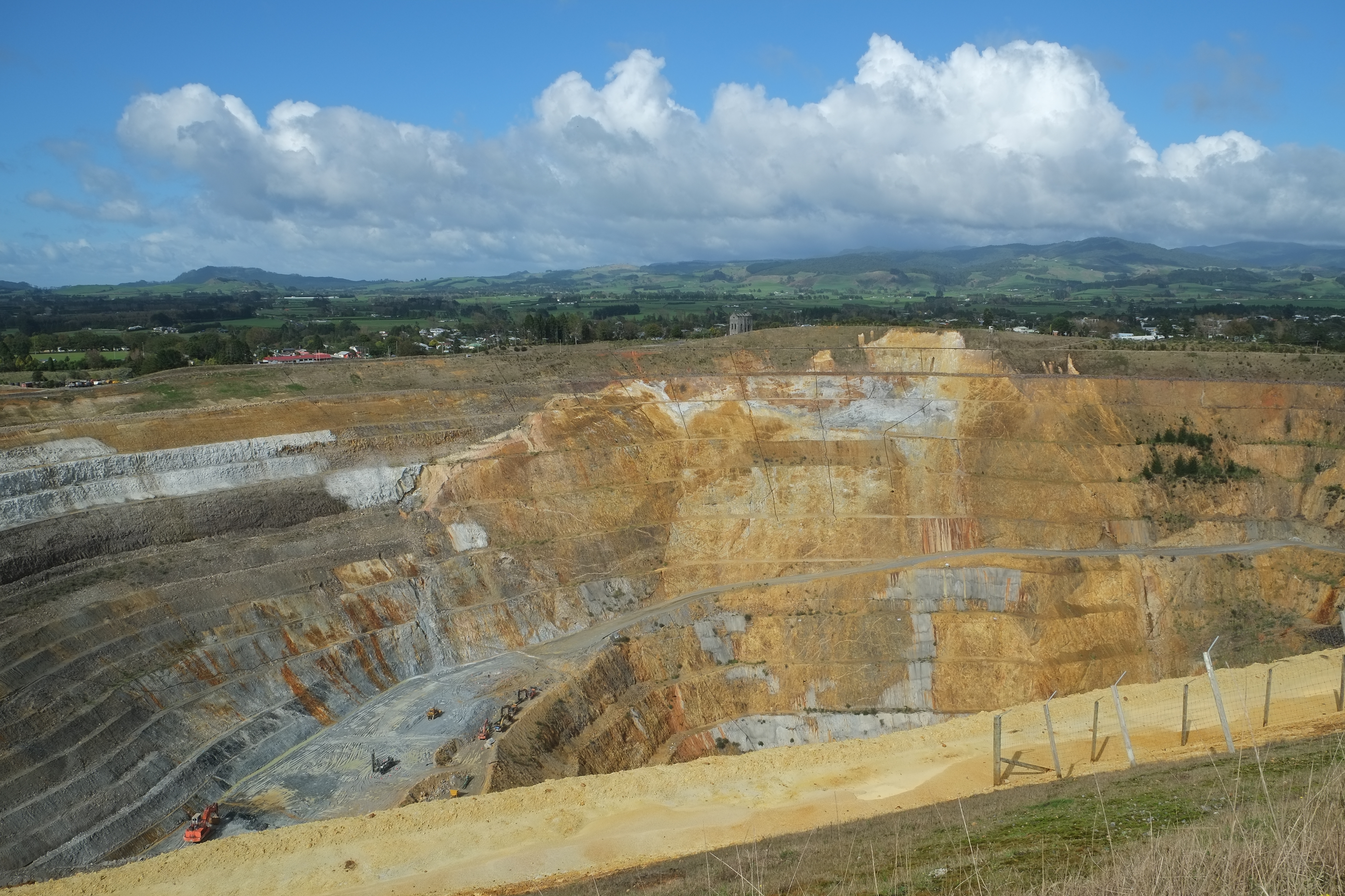
Waikino is a small settlement at the eastern end of a gorge in the North Island of New Zealand alongside the Ohinemuri River, between Waihi and the Karangahake Gorge. The Waikino district lies at the base of the ecologically sensitive Coromandel Peninsula with its subtropical rainforests, steep ravines and fast moving rivers and streams. The cascades of the Owharoa Falls lie just to the south west of the settlement. The New Zealand Ministry for Culture and Heritage gives a translation of "harmful waters" for . The population of Waikino was 213 people in 90 households in the 2013 New Zealand census. History Gold mining around Waikino has a history dating back to early colonisation of New Zealand. Waikino was the focal point of gold mining in the Waikato-Bay of Plenty district with the 1897 construction of the Victoria Battery on the edge of what was a busy town supporting the extensive local mining industry. Waikino's Victoria Battery processed ore from the large Martha Mine ... [...More Info...] [...Related Items...] OR: [Wikipedia] [Google] [Baidu] |
Waikino Village 1870's
Waikino is a small settlement at the eastern end of a gorge in the North Island of New Zealand alongside the Ohinemuri River, between Waihi and the Karangahake Gorge. The Waikino district lies at the base of the ecologically sensitive Coromandel Peninsula with its subtropical rainforests, steep ravines and fast moving rivers and streams. The cascades of the Owharoa Falls lie just to the south west of the settlement. The New Zealand Ministry for Culture and Heritage gives a translation of "harmful waters" for . The population of Waikino was 213 people in 90 households in the 2013 New Zealand census. History Gold mining around Waikino has a history dating back to early colonisation of New Zealand. Waikino was the focal point of gold mining in the Waikato-Bay of Plenty district with the 1897 construction of the Victoria Battery on the edge of what was a busy town supporting the extensive local mining industry. Waikino's Victoria Battery processed ore from the large Martha Mine ... [...More Info...] [...Related Items...] OR: [Wikipedia] [Google] [Baidu] |
Waihi
Waihi is a town in Hauraki District in the North Island of New Zealand, especially notable for its history as a gold mine town. The town is at the foot of the Coromandel Peninsula, close to the western end of the Bay of Plenty. The nearby resort town of Waihi Beach, ten kilometres to the east, is often regarded as the westernmost point of the Bay of Plenty region. To the west are the hills of the Kaimai Ranges. Road access from this direction is through the winding Karangahake Gorge road. Waihi has a warm and temperate climate but unusually high rainfall for New Zealand's east coast with an average annual rainfall of 2147 mm. Demographics Waihi covers and had an estimated population of as of with a population density of people per km2. Waihi had a population of 5,403 at the 2018 New Zealand census, an increase of 741 people (15.9%) since the 2013 census, and an increase of 783 people (16.9%) since the 2006 census. There were 2,223 households, comprising 2,604 males ... [...More Info...] [...Related Items...] OR: [Wikipedia] [Google] [Baidu] |
Ohinemuri River
The Ohinemuri River is located in the northern half of New Zealand's North Island, at the base of the Coromandel Peninsula. The river's source is north-east of the town of Waihi, close to the shore of the Bay of Plenty, but flows west rather than into the bay. It runs through the steep-sided Karangahake Gorge, forming a break between the Coromandel Range and the Kaimai Ranges. After , it joins the Waihou River near the town of Paeroa, south of the Firth of Thames, into which the Waihou River empties. Tributaries * Mataora Stream, running through the Golden Valley from a source only 1.5 km from the Bay of Plenty coastline. * Mangatoetoe Stream, which bisects the town of Waihi. * Waitete Stream, originating in the Coromandel Range near Waihi. This stream forms a natural boundary on the north-western side of Waihi and joins the Ohinemuri River immediately after Black Pool Dam. * Waimata Stream, starting in the Kaimai Ranges near the Athenree Gorge. * Waitekauri River, wit ... [...More Info...] [...Related Items...] OR: [Wikipedia] [Google] [Baidu] |
Karangahake Gorge
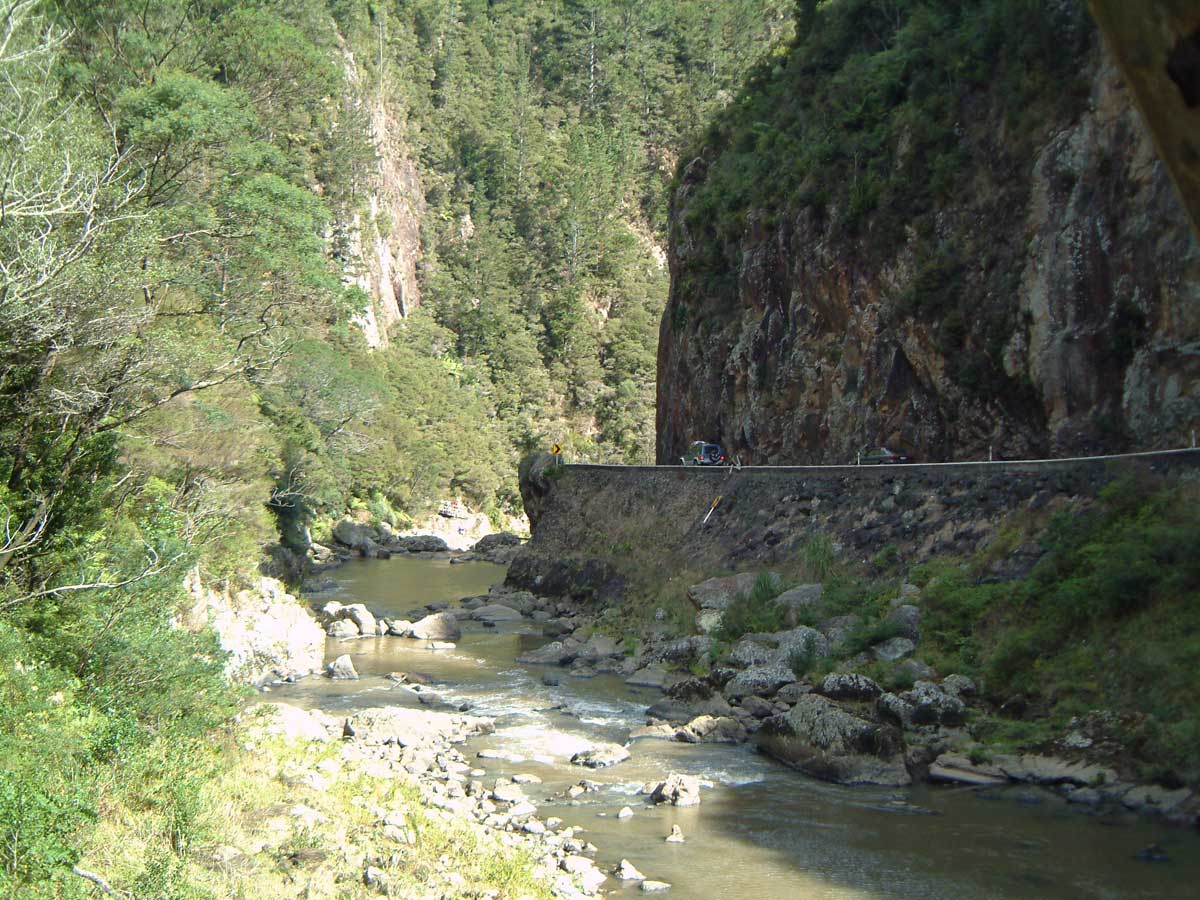
The Karangahake Gorge lies between the Coromandel and Kaimai ranges, at the southern end of the Coromandel Peninsula in New Zealand's North Island. A sharply winding canyon, it was formed by the Ohinemuri River. State Highway 2 passes through this gorge between the towns of Paeroa, Waikino and Waihi. This road is the main link between the Waikato region and the Bay of Plenty. The East Coast Main Trunk Railway used to run through the gorge until it was bypassed by the Kaimai Deviation - and the Karangahake Gorge section is now a combined walkway and cycleway, part of the Hauraki Rail Trail. There are also several walks and tracks starting at the Karangahake Reserve car park and picnic area; ranging from 30 minutes to over 2 hours. Mining The area has a strong connection to mining, and even in the 2010s, a number of companies have been prospecting and mining the area, though with much less visible and invasive methods than were used historically. The Talisman, Crown and W ... [...More Info...] [...Related Items...] OR: [Wikipedia] [Google] [Baidu] |
Hippies
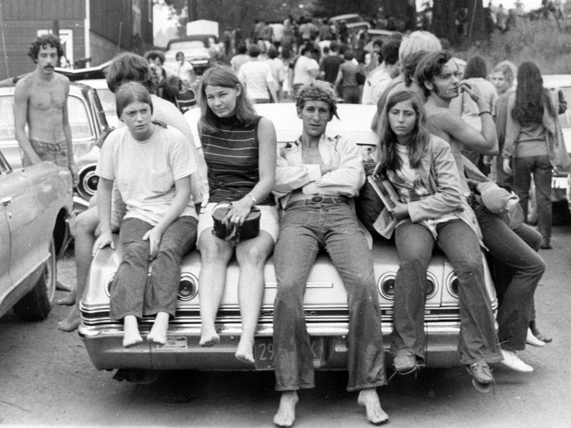
A hippie, also spelled hippy, especially in British English, is someone associated with the counterculture of the 1960s, originally a youth movement that began in the United States during the mid-1960s and spread to different countries around the world. The word ''hippie'' came from '' hipster'' and was used to describe beatniks who moved into New York City's Greenwich Village, in San Francisco's Haight-Ashbury district, and Chicago's Old Town community. The term ''hippie'' was used in print by San Francisco writer Michael Fallon, helping popularize use of the term in the media, although the tag was seen elsewhere earlier. The origins of the terms '' hip'' and ''hep'' are uncertain. By the 1940s, both had become part of African American jive slang and meant "sophisticated; currently fashionable; fully up-to-date". The Beats adopted the term ''hip'', and early hippies inherited the language and countercultural values of the Beat Generation. Hippies created their own communiti ... [...More Info...] [...Related Items...] OR: [Wikipedia] [Google] [Baidu] |
Hippie
A hippie, also spelled hippy, especially in British English, is someone associated with the counterculture of the 1960s, originally a youth movement that began in the United States during the mid-1960s and spread to different countries around the world. The word '' hippie'' came from '' hipster'' and was used to describe beatniks who moved into New York City's Greenwich Village, in San Francisco's Haight-Ashbury district, and Chicago's Old Town community. The term ''hippie'' was used in print by San Francisco writer Michael Fallon, helping popularize use of the term in the media, although the tag was seen elsewhere earlier. The origins of the terms ''hip'' and ''hep'' are uncertain. By the 1940s, both had become part of African American jive slang and meant "sophisticated; currently fashionable; fully up-to-date". The Beats adopted the term ''hip'', and early hippies inherited the language and countercultural values of the Beat Generation. Hippies created their own communit ... [...More Info...] [...Related Items...] OR: [Wikipedia] [Google] [Baidu] |
Hauraki District
Hauraki District is a territorial authority within the Hauraki region of New Zealand. The seat of the council is at Paeroa. The area covered by the district extends from the southwest coast of the Firth of Thames southeast towards Te Aroha, although that town lies beyond its boundaries. It extends eastwards to the Bay of Plenty coast, taking in the southernmost part of the Coromandel Peninsula. The rest of the peninsula is part of Thames-Coromandel District. Features of the district include the Karangahake Gorge, Whiritoa, the Hauraki Plains, Ngatea and the gold mining town of Waihi. Demographics Hauraki District covers and had an estimated population of as of with a population density of people per km2. live in Paeroa and in Waihi. Hauraki District had a population of 20,022 at the 2018 New Zealand census, an increase of 2,214 people (12.4%) since the 2013 census, and an increase of 2,166 people (12.1%) since the 2006 census. There were 7,869 households, comprising 9,8 ... [...More Info...] [...Related Items...] OR: [Wikipedia] [Google] [Baidu] |
Owharoa Falls
Owharoa Falls is a staircase waterfall in Waikato, New Zealand, located off Waitawheta Road in Karangahake Gorge, near State Highway 2, between Paeroa and Waihi, and close to the small settlement of Waikino Waikino is a small settlement at the eastern end of a gorge in the North Island of New Zealand alongside the Ohinemuri River, between Waihi and the Karangahake Gorge. The Waikino district lies at the base of the ecologically sensitive Coromandel .... References External links Owharoa Falls – "New Zealand Waterfalls" Waterfalls of Waikato Hauraki District {{Waterfall-stub ... [...More Info...] [...Related Items...] OR: [Wikipedia] [Google] [Baidu] |
New Zealand State Highway 2
State Highway 2 (SH 2) runs north–south through eastern parts of the North Island of New Zealand from the outskirts of Auckland to Wellington. It runs through Tauranga, Gisborne, Napier, Hastings and Masterton. It is the second-longest highway in the North Island, after State Highway 1, which runs the length of both of the country's main islands. For most of its length it consists of a two-lane single carriageway, with frequent passing lanes. There are sections of four-lane dual-carriageway expressway at Maramarua, Tauranga and Wellington. Route SH 2 leaves just north of Pōkeno, south of central Auckland. It heads east, crossing the Hauraki Plains before running the length of the Karangahake Gorge, a break in the hills between the Coromandel Peninsula and Kaimai Ranges. From the mining town of Waihi it runs southeast, skirting the edge of Tauranga Harbour, which it crosses on the Tauranga Harbour Bridge before connecting to the Tauranga Eastern Link, a four lan ... [...More Info...] [...Related Items...] OR: [Wikipedia] [Google] [Baidu] |
Crafts
A craft or trade is a pastime or an occupation that requires particular skills and knowledge of skilled work. In a historical sense, particularly the Middle Ages and earlier, the term is usually applied to people occupied in small scale production of Good (economics), goods, or their Maintenance, repair, and operations, maintenance, for example by tinkers. The traditional term ''craftsman'' is nowadays often replaced by ''artisan'' and by ''craftsperson'' (craftspeople). Historically, the more specialized crafts with high-value products tended to concentrate in urban centers and formed guilds. The skill required by their professions and the need to be permanently involved in the Trade, exchange of goods often demanded a generally higher level of education, and craftsmen were usually in a more privileged position than the peasantry in Complex society, societal hierarchy. The households of craftsmen were not as self-sufficient as those of people engaged in agricultural work, an ... [...More Info...] [...Related Items...] OR: [Wikipedia] [Google] [Baidu] |
Counterculture Of The 1960s
The counterculture of the 1960s was an anti-establishment cultural phenomenon that developed throughout much of the Western world in the 1960s and has been ongoing to the present day. The aggregate movement gained momentum as the civil rights movement in the United States continued to grow, and with the intensification of the Vietnam War, it would later become revolutionary to some. As the 1960s progressed, widespread social tensions also developed concerning other issues, and tended to flow along generational lines regarding human sexuality, women's rights, traditional modes of authority, rights of non-white people, end of racial segregation, experimentation with psychoactive drugs, and differing interpretations of the American Dream. Many key movements related to these issues were born or advanced within the counterculture of the 1960s. As the era unfolded, what emerged were new cultural forms and a dynamic subculture that celebrated experimentation, modern incarnations of B ... [...More Info...] [...Related Items...] OR: [Wikipedia] [Google] [Baidu] |
Waikato
Waikato () is a Regions of New Zealand, local government region of the upper North Island of New Zealand. It covers the Waikato District, Waipa District, Matamata-Piako District, South Waikato District and Hamilton, New Zealand, Hamilton City, as well as Hauraki Plains, Hauraki, Coromandel Peninsula, the northern King Country, much of the Taupō District, and parts of Rotorua, Rotorua District. It is governed by the Waikato Regional Council. The region stretches from Coromandel Peninsula in the north, to the north-eastern slopes of Mount Ruapehu in the south, and spans the North Island from the west coast, through the Waikato and Hauraki to Coromandel Peninsula on the east coast. Broadly, the extent of the region is the Waikato River catchment. Other major catchments are those of the Waihou River, Waihou, Piako River, Piako, Awakino River (Waikato), Awakino and Mokau River, Mokau rivers. The region is bounded by Auckland Region, Auckland on the north, Bay of Plenty on the east ... [...More Info...] [...Related Items...] OR: [Wikipedia] [Google] [Baidu] |


