|
WSR-1
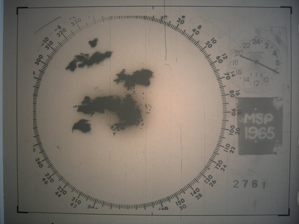
The WSR-1 or Weather Surveillance Radar-1 was one of the first weather radars and the first used by a civilian organization in the US. The WSR-1 series was a modified version of the AN/APS-2F radar, which the Weather Bureau (now the National Weather Service) acquired from the Navy. The WSR-1A, WSR-3, and WSR-4 were also variants of this radar. The first WSR-1 in the USA was at Washington National Airport in Washington, D.C. in 1947, and the last WSR-3 was retired by 1978. History In 1946, the US Weather Bureau (ancestor of the National Weather Service) retrieved 25 AN/APS-2F aeronautical radars from the US Navy. The radars have been modified and adapted to meteorology and then delivered at the rate of five per year. The modifications were conducted by the weather service and the modified radars took the successive names of WSR-1, WSR-1A, WSR-3 and WSR-4, depending on the gradual improvement of hardware. The first WSR-1 was put into service at the Washington, DC, national air ... [...More Info...] [...Related Items...] OR: [Wikipedia] [Google] [Baidu] |
WSR-57
WSR-57 radars were the USA's main weather surveillance radar for over 35 years. The National Weather Service operated a network of this model radar across the country, watching for severe weather. History The WSR-57 (Weather Surveillance Radar - 1957) was the first 'modern' weather radar. Initially commissioned at the Miami Hurricane Forecast Center, the WSR-57 was installed in other parts of the CONUS (continental United States). The WSR-57 was the first generation of radars designed expressly for a national warning network. The WSR-57 was designed in 1957 by Dewey Soltow using World War II technology. It gave only coarse reflectivity data and no velocity data, which made it extremely difficult to predict tornadoes. Weather systems were traced across the radar screen using grease pencils. Forecasters had to manually turn a crank to adjust the radar's scan elevation, and needed considerable skill to judge the intensity of storms based on green blotches on the radar scope. T ... [...More Info...] [...Related Items...] OR: [Wikipedia] [Google] [Baidu] |
WSR-57 Weather Radar Console
WSR-57 radars were the USA's main weather surveillance radar for over 35 years. The National Weather Service operated a network of this model radar across the country, watching for severe weather. History The WSR-57 (Weather Surveillance Radar - 1957) was the first 'modern' weather radar. Initially commissioned at the Miami Hurricane Forecast Center, the WSR-57 was installed in other parts of the CONUS (continental United States). The WSR-57 was the first generation of radars designed expressly for a national warning network. The WSR-57 was designed in 1957 by Dewey Soltow using World War II technology. It gave only coarse reflectivity data and no velocity data, which made it extremely difficult to predict tornadoes. Weather systems were traced across the radar screen using grease pencils. Forecasters had to manually turn a crank to adjust the radar's scan elevation, and needed considerable skill to judge the intensity of storms based on green blotches on the radar scope. T ... [...More Info...] [...Related Items...] OR: [Wikipedia] [Google] [Baidu] |
AN/APS-2F
The AN/APS-2, originally known as ASG (air-surface, model G), was a surface search radar developed by Philco originally for use in US Coast Guard blimps to detect German submarines. It proved better than several similar models then being built, and was ordered by the RAF Coastal Command where it was known as ASV Mark V. It was used primarily on British Liberator GR bombers, where they were instrumental in closing the Mid-Atlantic Gap and the subsequent destruction of the German U-boat fleet in May/June 1943. In the post-war era, many APS-2s were passed off for other services. Some of the USA's first weather radars were modified APS-2F radars.Roger C. Whiton, et al. "History of Operational Use of Weather Radar by U.S. Weather Services. Part I: The Pre-NEXRAD Era." Weather and Forecasting: Vol. 13, No. 2, pp. 219–243. 19 February 1998. American Meteorological Society. 5 April 200 Radar history The US Weather Bureau (precursor to the National Weather Service) obtained 25 AN/APS ... [...More Info...] [...Related Items...] OR: [Wikipedia] [Google] [Baidu] |
WSR-74
WSR-74 radars were Weather Surveillance Radars designed in 1974 for the National Weather Service. They were added to the existing network of the WSR-57 model to improve forecasts and severe weather warnings. Some have been sold to other countries like Australia, Greece, and Pakistan. Radar properties There are two types in the WSR-74 series, which are almost identical except for operating frequency. The WSR-74C (used for local warnings) operates in the C band, and the WSR-74S (used in the national network) operates in the S band (like the WSR-57 and the current WSR-88D). S band frequencies are better suited because they are not attenuated significantly in heavy rain while the C Band is strongly attenuated, and has a generally shorter maximum effective range. The WSR-74C uses a wavelength of 5.4 cm.Paul Sirvatka. "WSR - Weather Surveillance Radar." Radar. College of DuPage. 4 Apr. 200 It also has a dish diameter of 8 feet, and a maximum range of 579 km (313 n ... [...More Info...] [...Related Items...] OR: [Wikipedia] [Google] [Baidu] |
North Omaha Airport
North Omaha Airport is a privately owned, public-use airport eight miles northwest of Omaha, in Douglas County, Nebraska. Facilities North Omaha Airport covers 100 acres (40 ha) at an elevation of 1,324 feet (404 m). Its one runway, 17/35, is 3,173 by 40 feet (967 x 12 m) concrete. In the year ending August 29, 2018 the airport had 14,250 general aviation aircraft operations, average 39 per day. 57 aircraft were then based at the airport: 87% single-engine and 13% helicopter. The Omaha Police Department's air support unit was based at the airport from 1997–2019. References External links Aerial image as of 4 April 1999from USGS ''The National Map ''The National Map'' is a collaborative effort of the United States Geological Survey (USGS) and other federal, state, and local agencies to improve and deliver topographic information for the United States. The purpose of the effort is to pro ...'' Transportation in Omaha, Nebraska Airports in Nebraska Bu ... [...More Info...] [...Related Items...] OR: [Wikipedia] [Google] [Baidu] |
Traveling-wave Tube
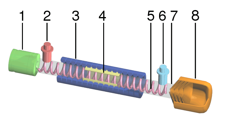
A traveling-wave tube (TWT, pronounced "twit") or traveling-wave tube amplifier (TWTA, pronounced "tweeta") is a specialized vacuum tube that is used in electronics to amplify radio frequency (RF) signals in the microwave range. The TWT belongs to a category of "linear beam" tubes, such as the klystron, in which the radio wave is amplified by absorbing power from a beam of electrons as it passes down the tube. Although there are various types of TWT, two major categories are: *''Helix TWT'' - in which the radio waves interact with the electron beam while traveling down a wire helix which surrounds the beam. These have wide bandwidth, but output power is limited to a few hundred watts. *''Coupled cavity TWT'' - in which the radio wave interacts with the beam in a series of cavity resonators through which the beam passes. These function as narrowband power amplifiers. A major advantage of the TWT over some other microwave tubes is its ability to amplify a wide range of frequencies ... [...More Info...] [...Related Items...] OR: [Wikipedia] [Google] [Baidu] |
Plan Position Indicator
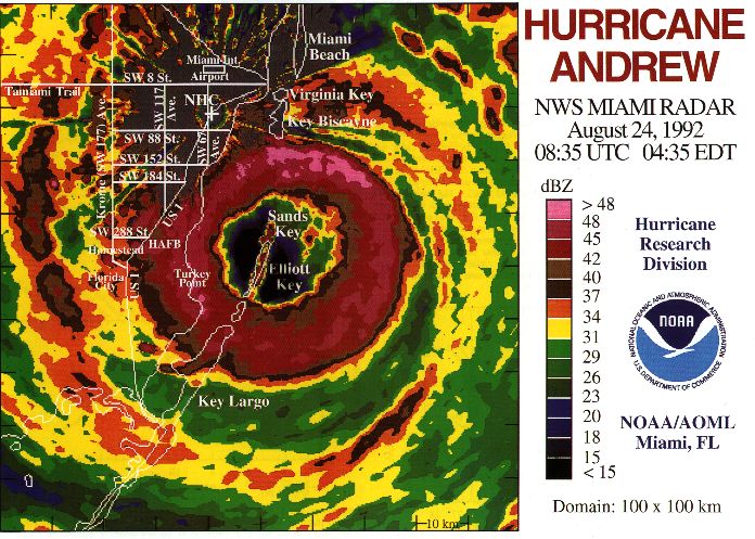
A plan position indicator (PPI) is a type of radar display that represents the radar antenna in the center of the display, with the distance from it and height above ground drawn as concentric circles. As the radar antenna rotates, a radial trace on the PPI sweeps in unison with it about the center point. It is the most common type of radar display. Description The radar antenna sends pulses while rotating 360 degrees around the radar site at a fixed elevation angle. It can then change angle or repeat at the same angle according to the need. Return echoes from targets are received by the antenna and processed by the receiver and the most direct display of those data is the PPI. The height of the echoes increases with the distance to the radar, as represented in the adjacent image. This change is not a straight line but a curve as the surface of the Earth is curved and ''sinks'' below the radar horizon. For fixed-site installations, north is usually represented at the top of ... [...More Info...] [...Related Items...] OR: [Wikipedia] [Google] [Baidu] |
Radar Display
A radar display is an electronic device to present radar data to the operator. The radar system transmits pulses or continuous waves of electromagnetic radiation, a small portion of which backscatter off targets (intended or otherwise) and return to the radar system. The receiver converts all received electromagnetic radiation into a continuous electronic analog signal of varying (or oscillating) voltage that can be converted then to a screen display. Modern systems typically use some sort of raster scan display to produce a map-like image. Early in radar development, however, numerous circumstances made such displays difficult to produce. People ultimately developed several different display types. Oscilloscopes Early radar displays used adapted oscilloscopes with various inputs. An oscilloscope generally receives three ''channels'' of varying (or oscillating) voltage as input and displays this information on a cathode ray tube. The oscilloscope amplifies the input voltages a ... [...More Info...] [...Related Items...] OR: [Wikipedia] [Google] [Baidu] |
Abilene, Texas
Abilene ( ) is a city in Taylor and Jones Counties in Texas, United States. Its population was 125,182 at the 2020 census, making it the 27th-most populous city in the state of Texas. It is the principal city of the Abilene metropolitan statistical area, which had an estimated population of 169,893, as of 2016. It is the county seat of Taylor County. Dyess Air Force Base is located on the west side of the city. Abilene is located off Interstate 20, between exits 279 on its western edge and 292 on the east. It is west of Fort Worth. The city is looped by I-20 to the north, US 83/84 on the west, and Loop 322 to the east. A railroad divides the city down the center into north and south. The historic downtown area is on the north side of the railroad. History Established by cattlemen as a stock shipping point on the Texas and Pacific Railway in 1881, the city was named after Abilene, Kansas, the original endpoint for the Chisholm Trail. The T&P had bypassed the town of Buffal ... [...More Info...] [...Related Items...] OR: [Wikipedia] [Google] [Baidu] |
NWS Office And WSR-3 Radar Hunstville International Airport
NWS may refer to: *National Weather Service, a U.S. government agency charged with issuing weather forecasts, advisories, watches, and warnings on a daily basis *National Woolsorters' Society, a former British trade union *News Corporation's NASDAQ ticker symbol for Class B stock *NWS (TV station), a television station in Adelaide, South Australia *Nuclear Weapons State, a term relating to the U.S., Russia, China, United Kingdom and France in the Nuclear Non-Proliferation Treaty * Not work safe, a web acronym interchangeable with the more widespread NSFW ("not safe for work") *Netherlands Worldwide Students, a worldwide network of Dutch students enrolled in foreign universities *North Warning System, a series of radar stations across Arctic North America *Nintendo World Store, Nintendo's showcase store in New York City *NWS Holdings, a listed company in Hong Kong *North Wilkesboro Speedway, a track that was the site of NASCAR Sprint Cup Series racing until closing in 1996, the track r ... [...More Info...] [...Related Items...] OR: [Wikipedia] [Google] [Baidu] |
NEXRAD
NEXRAD or Nexrad (Next-Generation Radar) is a network of 160 high-resolution S-band Doppler weather radars operated by the National Weather Service (NWS), an agency of the National Oceanic and Atmospheric Administration (NOAA) within the United States Department of Commerce, the Federal Aviation Administration (FAA) within the Department of Transportation, and the U.S. Air Force within the Department of Defense. Its technical name is WSR-88D (''Weather Surveillance Radar, 1988, Doppler''). NEXRAD detects precipitation and atmospheric movement or wind. It returns data which when processed can be displayed in a mosaic map which shows patterns of precipitation and its movement. The radar system operates in two basic modes, selectable by the operator – a slow-scanning ''clear-air mode'' for analyzing air movements when there is little or no activity in the area, and a ''precipitation mode'', with a faster scan for tracking active weather. NEXRAD has an increased emphasis on autom ... [...More Info...] [...Related Items...] OR: [Wikipedia] [Google] [Baidu] |
Albany, New York
Albany ( ) is the capital of the U.S. state of New York, also the seat and largest city of Albany County. Albany is on the west bank of the Hudson River, about south of its confluence with the Mohawk River, and about north of New York City. The city is known for its architecture, commerce, culture, institutions of higher education, and rich history. It is the economic and cultural core of the Capital District of the State of New York, which comprises the Albany–Schenectady–Troy Metropolitan Statistical Area, including the nearby cities and suburbs of Troy, Schenectady, and Saratoga Springs. With an estimated population of 1.1 million in 2013, the Capital District is the third most populous metropolitan region in the state. As of 2020, Albany's population was 99,224. The Hudson River area was originally inhabited by Algonquian-speaking Mohican (Mahican), who called it ''Pempotowwuthut-Muhhcanneuw''. The area was settled by Dutch colonists who, in 1614, built Fort ... [...More Info...] [...Related Items...] OR: [Wikipedia] [Google] [Baidu] |


