|
Věstonice Reservoir
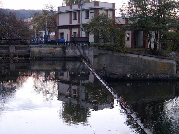
Věstonice Reservoir ( cz, Vodní nádrž Nové Mlýny II, Věstonická nádrž) is a reservoir on the Thaya River in the South Moravia. It is 1668 ha in area. The reservoir was built on the place of Mušov village. This is a Natural Reserve since 1994 together with the mouth of rivers Jihlava Jihlava (; german: Iglau) is a city in the Czech Republic. It has about 50,000 inhabitants. Jihlava is the capital of the Vysočina Region, situated on the Jihlava River on the historical border between Moravia and Bohemia. Historically, Jihlava i ... and Svratka. The Děvín Mountain peak is in prominence over the lake level . References Czech Republic Environmental Law Service - The Nove Mlyny reservoirs [...More Info...] [...Related Items...] OR: [Wikipedia] [Google] [Baidu] |
South Moravian Region
The South Moravian Region ( cs, Jihomoravský kraj; , ; sk, Juhomoravský kraj) is an administrative unit () of the Czech Republic, located in the south-western part of its historical region of Moravia (an exception is Jobova Lhota which traditionally belongs to Bohemia). The region's capital is Brno, the nation's 2nd largest city. South Moravia is bordered by the South Bohemian Region (west), Vysočina Region (north-west), Pardubice Region (north), Olomouc Region (north east), Zlín Region (east), Trenčín and Trnava Regions, Slovakia (south east) and Lower Austria, Austria (south). Administrative divisions The South Moravian Region is divided into 7 districts (Czech: ''okres''): There are in total 673 municipalities in the region, of which 49 have the status of towns. There are 21 municipalities with extended powers and 34 municipalities with a delegated municipal office. The region is famous for its wine production. The area around the towns of Mikulov, Znojmo, Velké ... [...More Info...] [...Related Items...] OR: [Wikipedia] [Google] [Baidu] |
Thaya River
The Thaya ( cs, Dyje ) is a river in Central Europe, the longest tributary to the river Morava. Its drainage basin is . It is ( with its longest source river German Thaya) long and meanders from west to east in the border area between Lower Austria (Austria) and South Moravia (Czech Republic), though the frontier does not exactly follow the river's course in most parts. Its source is in two smaller rivers, namely the German Thaya (''Deutsche Thaya'') and the Moravian Thaya ( cs, Moravská Dyje, german: Mährische Thaya), flowing together at Raabs an der Thaya. The confluence of Thaya and Morava is the southernmost and the lowest point of Moravia. Its name means "the inert". There is also a small village which bears the name Dyje, located near Znojmo. Geography In its upper reaches, the Thaya flows through deep gorges ( Podyjí), along which it passes many castles and chateaus. In Moravia, it has been dammed in several locations. Thaya gathers waters from the western half ... [...More Info...] [...Related Items...] OR: [Wikipedia] [Google] [Baidu] |
Jihlava (river)
The Jihlava (german: Igel) is a river in the Moravia (Czech Republic), a right tributary of the Svratka River. It originates in the Bohemian-Moravian Highlands ''(Českomoravská vrchovina)'' upland at the elevation of 665 m and flows to the Nové Mlýny reservoirs, where it enters the Svratka River. It is 180.8 km long, and its basin area is 2,997 km2. It flows through numerous towns and villages, including Jihlávka, Horní Ves, Horní Cerekev, Batelov, Dolní Cerekev, Kostelec, Dvorce, Rantířov, Jihlava, Malý Beranov, Luka nad Jihlavou, Bítovčice, Bransouze, Číchov, Přibyslavice, Třebíč, Vladislav, Kramolín, Mohelno, Biskoupky, Ivančice, Moravské Bránice, Nové Bránice, Dolní Kounice, Pravlov, Kupařovice, Medlov, Pohořelice, Přibice, Ivaň. The Dalešice Hydro Power Plant, including the Dalešice and Mohelno Dams, are constructed on the river. The longest tributaries of the river are the Oslava, Brtnice Brtnice (; german: Pir ... [...More Info...] [...Related Items...] OR: [Wikipedia] [Google] [Baidu] |
Svratka (river)
The Svratka (), formerly ''Švarcava'' (german: Schwarzach) is a river in the South Moravian Region of the Czech Republic. It is long, and its basin area is . It rises in the Bohemian-Moravian Highlands, converges with the Svitava in Brno, and flows into the Dyje (''Thaya'') a near Mikulov. The river is known in the local Moravian dialect as the ''Švarcava'' (from the German German(s) may refer to: * Germany (of or related to) ** Germania (historical use) * Germans, citizens of Germany, people of German ancestry, or native speakers of the German language ** For citizens of Germany, see also German nationality law **Ge ... name of the river ''Schwarzach''). References Rivers of the Vysočina Region Rivers of the South Moravian Region Břeclav District Žďár nad Sázavou District {{CzechRepublic-river-stub ... [...More Info...] [...Related Items...] OR: [Wikipedia] [Google] [Baidu] |
Czech Republic
The Czech Republic, or simply Czechia, is a landlocked country in Central Europe. Historically known as Bohemia, it is bordered by Austria to the south, Germany to the west, Poland to the northeast, and Slovakia to the southeast. The Czech Republic has a hilly landscape that covers an area of with a mostly temperate continental and oceanic climate. The capital and largest city is Prague; other major cities and urban areas include Brno, Ostrava, Plzeň and Liberec. The Duchy of Bohemia was founded in the late 9th century under Great Moravia. It was formally recognized as an Imperial State of the Holy Roman Empire in 1002 and became a kingdom in 1198. Following the Battle of Mohács in 1526, the whole Crown of Bohemia was gradually integrated into the Habsburg monarchy. The Protestant Bohemian Revolt led to the Thirty Years' War. After the Battle of White Mountain, the Habsburgs consolidated their rule. With the dissolution of the Holy Empire in 1806, the Cro ... [...More Info...] [...Related Items...] OR: [Wikipedia] [Google] [Baidu] |
Reservoir
A reservoir (; from French ''réservoir'' ) is an enlarged lake behind a dam. Such a dam may be either artificial, built to store fresh water or it may be a natural formation. Reservoirs can be created in a number of ways, including controlling a watercourse that drains an existing body of water, interrupting a watercourse to form an embayment within it, through excavation, or building any number of retaining walls or levees. In other contexts, "reservoirs" may refer to storage spaces for various fluids; they may hold liquids or gasses, including hydrocarbons. ''Tank reservoirs'' store these in ground-level, elevated, or buried tanks. Tank reservoirs for water are also called cisterns. Most underground reservoirs are used to store liquids, principally either water or petroleum. Types Dammed valleys Dammed reservoirs are artificial lakes created and controlled by a dam A dam is a barrier that stops or restricts the flow of surface water or underground streams ... [...More Info...] [...Related Items...] OR: [Wikipedia] [Google] [Baidu] |
Thaya
The Thaya ( cs, Dyje ) is a river in Central Europe, the longest tributary to the river Morava. Its drainage basin is . It is ( with its longest source river German Thaya) long and meanders from west to east in the border area between Lower Austria (Austria) and South Moravia (Czech Republic), though the frontier does not exactly follow the river's course in most parts. Its source is in two smaller rivers, namely the German Thaya (''Deutsche Thaya'') and the Moravian Thaya ( cs, Moravská Dyje, german: Mährische Thaya), flowing together at Raabs an der Thaya. The confluence of Thaya and Morava is the southernmost and the lowest point of Moravia. Its name means "the inert". There is also a small village which bears the name Dyje, located near Znojmo. Geography In its upper reaches, the Thaya flows through deep gorges ( Podyjí), along which it passes many castles and chateaus. In Moravia, it has been dammed in several locations. Thaya gathers waters from the western half ... [...More Info...] [...Related Items...] OR: [Wikipedia] [Google] [Baidu] |
Mušov
Mušov (german: Muschau) is a cadastral area and a defunct village in the municipality of Pasohlávky, South Moravian Region, Czech Republic. It covers an area of . Geography and history Mušov was the lowest-lying village in the Břeclav District. The village was destroyed despite the opposition of its inhabitants in the late 1970s, due to the decision of the then socialist authorities to build the Nové Mlýny reservoirs by flooding a unique ecosystem of the riparian forest in the area around the river Thaya. In 1976, the village was merged with the neighbouring municipality of Pasohlávky. The residents of Mušov could choose whether they wanted an apartment or to build a house in a newly built street in Pasohlávky. The village was flooded between 1981 and 1987. The post office in Mušov was last opened on 30 June 1978. Thanks to the efforts of conservationists, it was decided to preserve the medieval St Leonard's church, now standing on a small island in the middle of the ... [...More Info...] [...Related Items...] OR: [Wikipedia] [Google] [Baidu] |
Natural Reserve
A nature reserve (also known as a wildlife refuge, wildlife sanctuary, biosphere reserve or bioreserve, natural or nature preserve, or nature conservation area) is a protected area of importance for flora, fauna, or features of geological or other special interest, which is reserved and managed for purposes of conservation and to provide special opportunities for study or research. They may be designated by government institutions in some countries, or by private landowners, such as charities and research institutions. Nature reserves fall into different IUCN categories depending on the level of protection afforded by local laws. Normally it is more strictly protected than a nature park. Various jurisdictions may use other terminology, such as ecological protection area or private protected area in legislation and in official titles of the reserves. History Cultural practices that roughly equate to the establishment and maintenance of reserved areas for animals date back to ... [...More Info...] [...Related Items...] OR: [Wikipedia] [Google] [Baidu] |
Děvín In Moravia (Pavlov Hills)
Děvín (german: Mayden Berg) is a double peak mountain in the Pavlov municipality in the South Moravian Region of the Czech Republic. With an elevation of , it is the highest mountain of the Pavlov Hills within the Mikulov Highlands, and of the Pálava Protected Landscape Area. It is located right on trace where runs line of drainage divide of Upper Thaya drainage and Thaya/Morava mesodrainage. History The summit of Děvín has the remains of a huge Iron Age hill fort, while the ancient Amber Route runs neighbors of the mountains base, and all archaic roads in landscape, originally created by animals and later overtaken by humans. The area around base of the mountain is permanently settled longer than last 30,000 years. Since Cromagnos hunters, ower Celtic tribes settlement, Roman fortress, Great Moravia hillforts ( Strachotín and Děvín). Geology The entire Děvín massif consists mainly by Jurassic limestone, i.e. series of rocks generated during sedimentation. The b ... [...More Info...] [...Related Items...] OR: [Wikipedia] [Google] [Baidu] |
Nové Mlýny Reservoirs
The Nové Mlýny reservoirs ( cs, Vodní dílo Nové Mlýny) are three reservoirs behind the Nové Mlýny Dam on the Thaya River in the Czech Republic. The lower reservoir, 1,668 ha in area, is the Novomlýnská (or Nové Mlýny) Reservoir, the middle reservoir, 1,031 ha, is the Věstonice Reservoir Věstonice Reservoir ( cz, Vodní nádrž Nové Mlýny II, Věstonická nádrž) is a reservoir on the Thaya River in the South Moravia. It is 1668 ha in area. The reservoir was built on the place of Mušov village. This is a Natural Reserve sin ... and the upper reservoir, 528 ha, is the Mušovská (or Mušov) Reservoir. ReferencesCzech Republic Environmental Law Service - The Nove Mlyny reservoirs [...More Info...] [...Related Items...] OR: [Wikipedia] [Google] [Baidu] |


