|
Vrishabhavati River
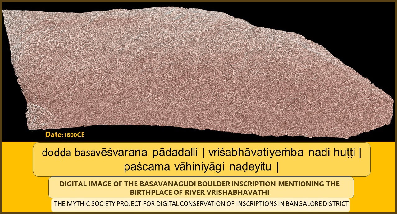
The Vrishabhavathi River is a minor river, a tributary of the Arkavathy, that flows through the south of the Indian city of Bangalore. The river was once so pristine that the water from it was used for drinking and used by the famous Gali Anjaneya temple but is now highly polluted due to pollutants from industrial, agricultural and domestic sources. Etymology Vrishabhavathi is derived from the Sanskrit word ''Vrishabha'' which refers to a bull. The river is believed to originate at the feet of the monolithic Nandi statue at the Big Bull Temple in Basavanagudi, hence giving it the name ''Vrishabhavathi''. Course The origin of the river is near the Dakshinamukha Nandi Tirtha or the Kadu Malleshwara Temple in Malleswaram, and it flows through major areas like Nayandahalli, Rajarajeshwari Nagar and Kengeri. The river can be seen near the Mantri Mall Malleswaram, Magadi Road and Mysore Road metro stations. The river culminates in a reservoir named after itself Vrishabhavathi Res ... [...More Info...] [...Related Items...] OR: [Wikipedia] [Google] [Baidu] |
Karnataka
Karnataka (; ISO: , , also known as Karunāḍu) is a state in the southwestern region of India. It was formed on 1 November 1956, with the passage of the States Reorganisation Act. Originally known as Mysore State , it was renamed ''Karnataka'' in 1973. The state corresponds to the Carnatic region. Its capital and largest city is Bengaluru. Karnataka is bordered by the Lakshadweep Sea to the west, Goa to the northwest, Maharashtra to the north, Telangana to the northeast, Andhra Pradesh to the east, Tamil Nadu to the southeast, and Kerala to the southwest. It is the only southern state to have land borders with all of the other four southern Indian sister states. The state covers an area of , or 5.83 percent of the total geographical area of India. It is the sixth-largest Indian state by area. With 61,130,704 inhabitants at the 2011 census, Karnataka is the eighth-largest state by population, comprising 31 districts. Kannada, one of the classical languages of India, ... [...More Info...] [...Related Items...] OR: [Wikipedia] [Google] [Baidu] |
Rajarajeshwari Nagar, Bangalore
Rajarajeshwari Nagar, officially Rajarajeshwari Nagara is a residential neighborhood in Bangalore, Karnataka, India. It is located in the southwestern part of Bangalore along the Mysore Road, with Nagarbhavi and the Bangalore University to the north and north west and Kengeri to the south west. There is a prominent arch shaped structure on Mysore Road which serves as the most popular entrance to this locality. The area was named after Jnanakshi Rajarajeshwari Temple which is located in the Rajarajeshwari Nagar. The locality has plenty of greenery and has contributed to many rallies and protests regarding the nature. Ideal Homes, BEML Layout, BHEL Layout, Krishna Garden, Halagevaderahalli, Kenchenahalli, Pattanagere, Gattigere, Channasandra and Ganakal are some of the sublocalities within Rajarajeshwari Nagar. Culture The Karnataka Chitrakala Parishath is set to open a 14-acre campus in Rajarajeshwari Nagar by 2020. The neighbourhood is known for its vigilance against garbage d ... [...More Info...] [...Related Items...] OR: [Wikipedia] [Google] [Baidu] |
Chief Minister Of Karnataka
The chief minister of Karnataka, formerly known as the chief minister of Mysore, is the chief executive officer of the government of the Indian state of Karnataka. As per the Constitution of India, the governor of Karnataka is the state's ''de jure'' head, but ''de facto'' executive authority rests with the chief minister, a template applicable to all other Indian states. Following elections to the Karnataka Legislative Assembly, the governor usually invites the political party (or a coalition of political parties) with a majority of assembly seats to form the government in the state. The governor appoints the chief minister, whose council of ministers is collectively responsible to the assembly. Given that he has the confidence of the assembly, the chief minister's term is for five years, renewable, and is subject to no term limits.Durga Das Basu. ''Introduction to the Constitution of India''. 1960. 20th Edition, 2011 Reprint. pp. 241, 245. LexisNexis Butterworths Wadhwa Nagpur. ... [...More Info...] [...Related Items...] OR: [Wikipedia] [Google] [Baidu] |
Vijayanagara Empire
The Vijayanagara Empire, also called the Karnata Kingdom, was a Hinduism, Hindu empire based in the region of South India, which consisted the modern states of Karnataka, Andhra Pradesh, Tamil Nadu, Kerala, Goa and some parts of Telangana and Maharashtra. It was established in 1336 by the brothers Harihara I and Bukka Raya I of the Sangama dynasty, members of a pastoralist Herder, cowherd community that claimed Yadava lineage. The empire rose to prominence as a culmination of attempts by the southern powers to ward off Islamic invasions of India, Perso-Turkic Islamic invasions by the end of the 13th century. At its peak, it subjugated almost all of South India's ruling families and pushed the sultans of the Deccan beyond the Tungabhadra River, Tungabhadra-Krishna River, Krishna river doab region, in addition to annexing modern day Odisha (ancient Kalinga (historical region), Kalinga) from the Gajapati Empire, Gajapati Kingdom thus becoming a notable power. It lasted until 1646 ... [...More Info...] [...Related Items...] OR: [Wikipedia] [Google] [Baidu] |
Vyasaraya
Vyāsatīrtha (. 1460 – 1539), also called ''Vyasaraja'' or ''Chandrikacharya'', was a Hindu philosopher, scholar, polemicist, commentator and poet belonging to the Madhwacharya's Dvaita order of Vedanta. As the patron saint of the Vijayanagara Empire, Vyasatirtha was at the forefront of a golden age in Dvaita which saw new developments in dialectical thought, growth of the Haridasa literature under bards like Purandara Dasa and Kanaka Dasa and an amplified spread of Dvaita across the subcontinent. Three of his polemically themed doxographical works ''Nyayamruta'', ''Tatparya Chandrika'' and ''Tarka Tandava'' (collectively called ''Vyasa Traya'') documented and critiqued an encyclopaedic range of sub-philosophies in Advaita, Visistadvaita, Mahayana Buddhism, Mimamsa and Nyaya, revealing internal contradictions and fallacies. His ''Nyayamruta'' caused a significant stir in the Advaita community across the country requiring a rebuttal by Madhusudhana Saraswati through ... [...More Info...] [...Related Items...] OR: [Wikipedia] [Google] [Baidu] |
Bugle Rock
Bugle Rock () is a massive rock in the Basavanagudi area of South Bangalore, in the state of Karnataka. It is an abrupt rise above the ground of peninsular gneiss as the main rock formation and with an assessed age of about 3,000 million years. Bugle Rock has generated wide interest among the scientific community. Kempe Gowda II (who came to power in 1585), the feudal ruler of Bangalore, is credited with building four watchtowers setting limits for Bangalore's expansion, which included a tower on the Bugle Rock (on the southern boundary) as it commands a panoramic view of Bangalore city. It is said that at sunset a sentry would blow the bugle and hold a torch (Kannada:panju) which was visible from the other three watch towers (one on the southern bank of the Kempambudi tank on the west, the second near Ulsoor Lake in the east and the third tower adjoining Ramana Maharshi Ashram on Bellary Road, namely Mekhri Circle in the north). This was done to inform people that everything wa ... [...More Info...] [...Related Items...] OR: [Wikipedia] [Google] [Baidu] |
List Of Wards In Bangalore
For administrative purposes, the city of Bangalore is divided into nine zones, which are further subdivided into a total of 198 wards administered by the Bruhat Bengaluru Mahanagara Palike The Bruhat Bengaluru Mahanagara Palike (BBMP) is the administrative body responsible for civic amenities and some infrastructural assets of the Greater Bengaluru metropolitan area. It is the fourth largest Municipal Corporation in India an ... (BBMP). After delimination in 2020, BBMP has decided to increase the number of wards to 243. 45 new wards were added to the existing 198 wards. Headed by BBMP Commissioner Manjunath Prasad, the Delimitation Commission, will decide on further how to divide the city to 243 wards. See also * 2010 Greater Bengaluru Municipal Corporation election * 2015 Greater Bengaluru Municipal Corporation election * Yelahanka Ward * List of wards in Bangalore (2010-2020) * List of wards in Bangalore (1995-2006) * List of wards in Bangalore (1989-1995) R ... [...More Info...] [...Related Items...] OR: [Wikipedia] [Google] [Baidu] |
Kanakapura
Kanakapura is a town in the Ramanagara district of Karnataka on the banks of the Arkavathi river and the administrative center of the taluk of the same name. Previously belonged to Bangalore Rural District. It was formerly the largest constituency in the country. The taluk is very widespread (). It is located among the lush green forests of the state of Karnataka. The town is a tourism hotspot and an often visited tourist favorite in the entire state of Karnataka, as it has something for everyone ranging from avid trekkers to history buffs and wildlife enthusiasts.The forest area in this taluk is very wide and about half of the Bannerghatta National Park is located in our Kanakapura area.Kodihalli wildlife range and harohalli wildlife range its division.The Kaveri Wildlife Sanctuary consists of two main zones namely the Sangam Wildlife range, the Mugur Wildlife range Geography Kanakapura is located at . It has an average elevation of . Kanakapura is south of Bangalore (c ... [...More Info...] [...Related Items...] OR: [Wikipedia] [Google] [Baidu] |
Arkavathy River
The Arkavati is an important mountain river in Karnataka, India, originating at Nandi Hills of Chikkaballapura district. It is a tributary of the Kaveri, which it joins at 34 km south of Kanakapura, Ramanagara District called Sangama in Kannada, after flowing through Ramanagara and Kanakapura. The river drains into the Chikkarayappanahalli Lake near Kanivenarayanapura. Kumudavathi and Vrishabhavathi rivers are tributaries to this river. It forms ''Chunchi falls'' near Haroshivanahalli. It joins Cauvery river as a tributary near Mekedatu. Course The river originates in the Nandi Hills in the Chikkaballapura district and flows through Ramanagara and Kanakapura before it eventually drains into the Chikkarayappanahalli Lake near Kanivenarayanapura. The Arkavati joins the Kaveri river around 34 km south of Kanakapura in the Ramanagara District. The river has three tributaries; Kumudavathi River, Suvarnamukhi River, and Vrishabhavathi River. History The river has histori ... [...More Info...] [...Related Items...] OR: [Wikipedia] [Google] [Baidu] |
Bidadi
Bidadi is a town situated on the Bengaluru – Mysuru expressway and is part of the Ramnagar in the state of Karnataka. The town is located 32 km from Bangalore towards Mysuru and is connected by both rail and bus to Bengaluru City. It is famous for a food dish called the ''"Thatte Idli"'' which is a larger flatter variant of the traditional south Indian ''idli''. Education Bidadi is home to the following schools – Jnana Vikas National Public School, Vagdevi Public School, St. Thomas Residential School, Suvishesha Gnana Peetha School, Thyagaraja Central School, JVS, Basaveshwara High School, Government School, and Simran School. Two nursing schools are also in Bidadi – Subhash Nursing School and Ikon College of Nursing. Industries The automobile manufacturer Toyota has its subsidiarity unit Toyota Kirloskar Toyota Kirloskar Motor Private Limited (TKM) is an Indian joint venture between Toyota Motor Corporation (89%) and Kirloskar Group (11%), for the manufactu ... [...More Info...] [...Related Items...] OR: [Wikipedia] [Google] [Baidu] |
Mysore Road Metro Station
Mysore Road is a metro station on the Purple Line of the Namma Metro serving Muthachari Industrial Estate and Deepanjali Nagar, Bangalore. It was opened to the public on 16 November 2015. Station layout Entry/Exits There are 4 Entry/Exit points – A, B, C and D. Commuters can use either of the points for their travel. * Entry/Exit point A: Towards Nayandahalli Junction side with wheelchair accessibility * Entry/Exit point B: Towards Deepanjali Nagar side * Entry/Exit point C: Towards Outer Ring Road side * Entry/Exit point D: Towards Nayandahalli Junction side with wheelchair accessibility See also *Bangalore *List of Namma Metro stations *Transport in Karnataka Karnataka, a state in South India has a well-developed transport system. Its capital city, Bengaluru is well-connected by air to domestic and international destinations and the Kempegowda International Airport (KIA) in the city is one of the busi ... * List of metro systems * List of rapid transit systems in ... [...More Info...] [...Related Items...] OR: [Wikipedia] [Google] [Baidu] |


.jpg)


