|
Vrbas Banovina
The Vrbas Banovina or Vrbas Banate ( sh-Latn-Cyrl, separator=" / ", Vrbaska banovina, Врбаска бановина), was a province ( banovina) of the Kingdom of Yugoslavia between 1929 and 1941. It was named after the Vrbas River and consisted mostly of territory in western Bosnia (part of historical and present-day Bosnia and Herzegovina) with its capital at Banja Luka. Dvor district of present-day Croatia was also part of the Vrbas Banovina. Borders According to the 1931 Constitution of the Kingdom of Yugoslavia, :''The Vrbas Banovina is bounded, from the north-eastern boundary of the district of Dvor (south-west of Kostajnica) by the river Una to the point where it flows into the Sava; it then follows the course of the Sava, which it leaves to follow the eastern boundaries of the districts of Derventa and Gračanica, as far as the river Bosna at the village of Dolac. It then continues along the south-western boundary of the district of Maglaj as far as the intersection ... [...More Info...] [...Related Items...] OR: [Wikipedia] [Google] [Baidu] |
Subdivisions Of The Kingdom Of Yugoslavia
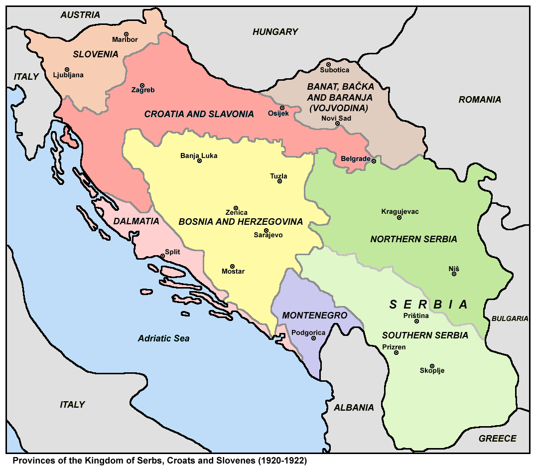
The subdivisions of the Kingdom of Yugoslavia (initially known as the Kingdom of Serbs, Croats, and Slovenes) existed successively in three different forms. From 1918 to 1922, the kingdom maintained the pre-World War I subdivisions of Yugoslavia's predecessor states. In 1922, the state was divided into 33 ''oblasts'' or provinces and, in 1929, a new system of nine banates (in Serbo-Croatian, the word for "banate" is ''banovina'') was implemented. Pre-Yugoslav subdivisions (1918–1922) From 1918 to 1922, Kingdom of Serbs, Croats, and Slovenes continued to be subdivided into the pre-World War I divisions of Austria-Hungary and the formerly independent kingdoms of Serbia and Montenegro. Provinces (''pokrajine'') were: # Slovenia # Croatia and Slavonia # Dalmatia # Bosnia and Herzegovina # Banat, Bačka and Baranja # Serbia ## Northern Serbia ## Southern Serbia # Montenegro These were subdivided into districts and counties: # District of Andrijevica (former Montenegro) # Distric ... [...More Info...] [...Related Items...] OR: [Wikipedia] [Google] [Baidu] |
Bosna (river)
The Bosna () is the third longest river in Bosnia and Herzegovina, and is considered one of the country's three major internal rivers, along with the Neretva and the Vrbas. The other three major rivers of Bosnia and Herzegovina are the Una, to the northwest; the Sava, to the north, and the Drina, to the east. This river is the namesake of Bosnia. The river Bosna flows for . The river is possibly mentioned for the first time during the 1st century AD by Roman historian Marcus Velleius Paterculus under the name ''Bathinus flumen''. Another basic source that is associated with the hydronym ''Bathinus'' is the Salonitan inscription of the governor of Dalmatia, Publius Cornelius Dolabella, where it is said that the ''Bathinum'' river divides the Breuci from the Osseriates. And also by the name of Basante. There was also the name Bason on the map ''From Istanbul to Vienna'' along the Danube and the Black Sea — a river-centric map by the Venetian cartographer Stefano Scolari, ... [...More Info...] [...Related Items...] OR: [Wikipedia] [Google] [Baidu] |
Bosanski Petrovac
Bosanski Petrovac ( sr-cyrl, Босански Петровац) is a town and municipality located in the Una-Sana Canton of the Federation of Bosnia and Herzegovina, an entity of Bosnia and Herzegovina. As of 2013 census, the municipality has a population of 7,328 inhabitants, while the town has a population of 3,427 inhabitants. History The settlement has existed since Roman times. It was conquered by the Ottoman Empire somewhere between 1520 and 1530. From 1929 to 1941, Bosanski Petrovac was part of the Vrbas Banovina of the Kingdom of Yugoslavia. During the Second World War, it was a Partisan stronghold which was conveniently located close to Marshal Josip Broz Tito's headquarters in Drvar. On 6 December 1942 the Women's Antifascist Front of Yugoslavia was established in the town. During the 1992–95 Bosnian War, the town's Serb majority remained in the city while the Bosniaks and Croats were forced to leave their homes. Then in 1995, as the war was nearing its end, the ... [...More Info...] [...Related Items...] OR: [Wikipedia] [Google] [Baidu] |
Livno
Livno ( sr-cyrl, –õ–∏–≤–Ω–æ, ) is a city and the administrative center of Canton 10 of the Federation of Bosnia and Herzegovina, an entity of Bosnia and Herzegovina. It is situated on the river Bistrica in the southeastern edge of the Livno Field at the foot of Kruzi plateau which are located beneath the Cincar mountain and rocky hill Crvenice. Livno is the centre of the Canton 10 which mainly covers an area of the historical and geographical region of Tropolje. As of 2013, it has a population of 37,487 inhabitants. The town, with its historic ruins and old town from the 9th century, was first mentioned in 892, developing at the crossroads between the Adriatic coast and inland, i.e., regions of Bosnia, Dalmatia, Herzegovina, and Krajina. History The plains of Livno have been populated since approximately 2000 BC. In the late Bronze Age, the Neolithic population was replaced by more Indo-European tribes known as the Illyrians. The region was inhabited by Illyrian tribe of Dalmat ... [...More Info...] [...Related Items...] OR: [Wikipedia] [Google] [Baidu] |
Troglav (Bosnia And Herzegovina)
Troglav ( sr-Cyrl, Троглав) is the highest peak of the Dinara Mountain Range in the Dinaric Alps (also known as ''Dinarides''). Dinara is the longest massif within karstic mountain chain of the western Balkan peninsula. Troglav is located in the territory of Bosnia and Herzegovina. It is named after Triglav, Slavic god. The name literally means "three headed". The Troglav group is around 30 km long and around 15 km wide, making it the largest in the range. On the northwestern side, it is separated from the Dinara group by the Privija pass (1230 m) and on the southeast from the Kamešnica group by Vaganj (1173 m) road pass, which connects Sinj in Croatia with Livno in Bosnia. On the northeastern, Bosnian side, lies the huge karstic field of Livanjsko Polje (700 m), which is 65 km long. On the southwestern, Croatian side, there is the Cetina river valley with 15 km long Peruća Lake (''Perućko Jezero''), continuing on to the Sinjsko Polje. ... [...More Info...] [...Related Items...] OR: [Wikipedia] [Google] [Baidu] |
Glamoč
Glamoč ( sr-cyrl, Гламоч) is a town and municipality located in Canton 10 of the Federation of Bosnia and Herzegovina, an entity of Bosnia and Herzegovina. It is situated in southwestern Bosnia and Herzegovina, at the foothills of Staretina and Velika Golija mountains, and on the edge of the central part of the Glamoč Field. The municipality encompasses the town of Glamoč as a seat of the municipality and more than 50 villages and hamlets situated along the Field. It mainly covers an area of the historical and geographical region of Tropolje. Name During the Ottoman Empire, Ottoman era the town was recorded as Biograd (White town), Belgradčik and Biogradaz. Geography Climate The climate of Glamoč is classified as an oceanic climate (''Cfb'' in Köppen climate classification#GROUP C: Temperate/mesothermal climates, Köppen climate classification system), near the boundary of the humid continental climate. Glamoč has four separate seasons. Summers are warm, and winte ... [...More Info...] [...Related Items...] OR: [Wikipedia] [Google] [Baidu] |
Gmići
Gmići is a village in the municipality of Prozor-Rama, Bosnia and Herzegovina Bosnia and Herzegovina ( sh, / , ), abbreviated BiH () or B&H, sometimes called Bosnia–Herzegovina and often known informally as Bosnia, is a country at the crossroads of south and southeast Europe, located in the Balkans. Bosnia and H .... Demographics According to the 2013 census, its population was 910. References Populated places in Prozor-Rama {{HerzegovinaNeretvaCanton-geo-stub ... [...More Info...] [...Related Items...] OR: [Wikipedia] [Google] [Baidu] |
Podripci
Podripci ( sr, Подрипци) is a village in the municipality of Bugojno, Bosnia and Herzegovina Bosnia and Herzegovina ( sh, / , ), abbreviated BiH () or B&H, sometimes called Bosnia–Herzegovina and often known informally as Bosnia, is a country at the crossroads of south and southeast Europe, located in the Balkans. Bosnia and H .... Demographics According to the 2013 census, its population was 153. References Populated places in Bugojno {{CentralBosniaCanton-geo-stub ... [...More Info...] [...Related Items...] OR: [Wikipedia] [Google] [Baidu] |
Travnik
Travnik is a town and a municipality in Bosnia and Herzegovina. It is the administrative center of Central Bosnia Canton of the Federation of Bosnia and Herzegovina. It is situated in central Bosnia and Herzegovina, west of Sarajevo. As of 2013, the town had a population of 15,344 inhabitants, while the municipality had 53,482 inhabitants. Historically, it was the capital city of the governors of Bosnia from 1699 to 1850, and has a cultural heritage dating from that period. Geography Travnik is located near the geographic center of Bosnia and Herzegovina at . The river Lašva passes through the town, flowing from west to east before joining the Bosna. Travnik itself is built in the large Lašva valley, which connects the Bosna river valley in the east with the Vrbas river valley in the west. Travnik is found above sea level. Its most distinguishing geographic feature are its mountains, Vilenica and Vlašić. Vlašić, named after the Vlachs, is one of the tallest mounta ... [...More Info...] [...Related Items...] OR: [Wikipedia] [Google] [Baidu] |
Zenica
Zenica ( ; ; ) is a city in Bosnia and Herzegovina and an administrative and economic center of the Federation of Bosnia and Herzegovina's Zenica-Doboj Canton. It is located in the Bosna (river), Bosna river valley, about north of Sarajevo. The city is known for its Ironworks Zenica factory but also as a significant University of Zenica, university center. According to the 2013 population census in Bosnia and Herzegovina, 2013 census, the settlement of Zenica itself counts 70,553 citizens and the administrative area 110,663. The urban part of today's city was formed in several phases, including Neolithic, Illyrian, the Roman Municipium of ''Bistua Nuova'' (2nd–4th century; old name of the city), with an early Christian dual basilica. Traces of an ancient settlement have been found here as well; villa rustica, thermae, a temple, and other buildings were also present. Earliest findings in the place date from the period 3000–2000 BC; they were found in the localities of DrivuŠ... [...More Info...] [...Related Items...] OR: [Wikipedia] [Google] [Baidu] |


.jpg)