|
Vradeto
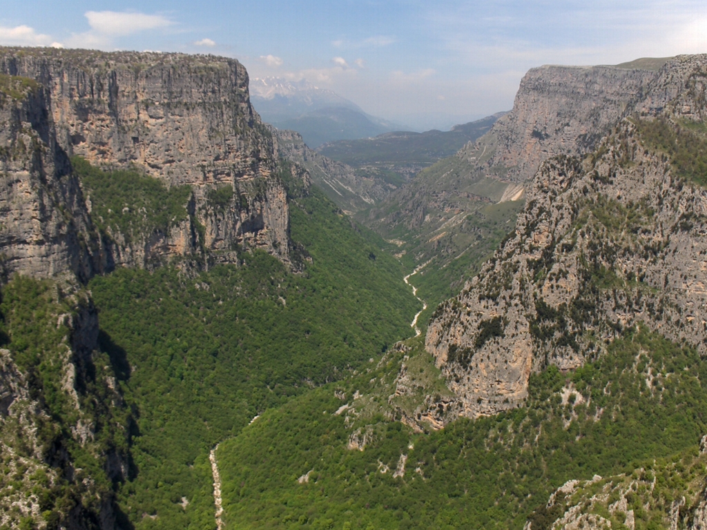
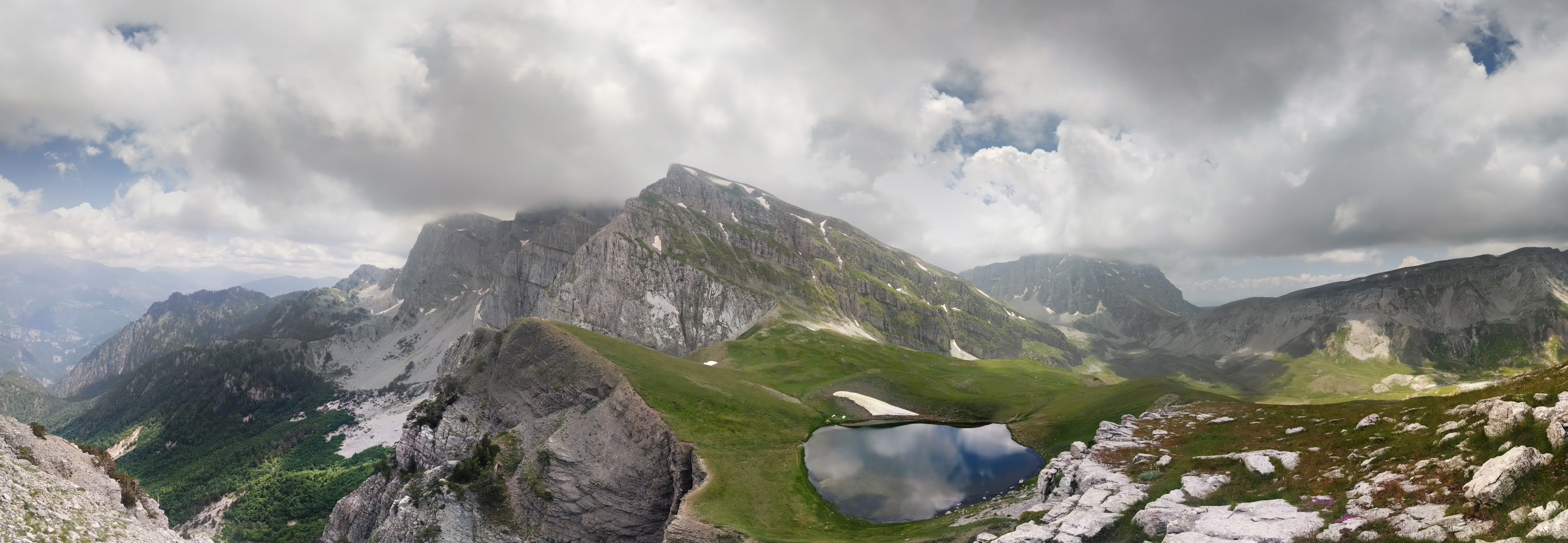
Vradeto ( el, Βραδέτο) is a village in the Greek Zagori region ( Epirus region). It lies at a height of 1340m on Mt Tymphe in the Pindus mountain range. It is the highest of the 44 villages of Zagori. It is the middle of the Vikos–Aoös National Park and is about 50 km away from Ioannina. It is located only a few kilometers from the Vikos Gorge and near one of the best vantage points, Beloe (Beloi) (perhaps a Slavic word meaning "good view" or "balcony"). It is located also close to an alpine lake called Drakolimni (''Dragon’s Lake''), one of several such lakes. The lakes are named after the amphibian newts ('' Ichthyosaura alpestris'') that live in them, around which there are myths of dragons. The myths are echoes of ancient myths about the hero Pindus, son of Macedon, who either befriended or according to another myth killed a dragon. Nearest places *Tsepelovo, east (distance: 10 km) * Kapesovo, south (distance: 5 km) Population History Until t ... [...More Info...] [...Related Items...] OR: [Wikipedia] [Google] [Baidu] |
Zagori
Zagori ( el, Ζαγόρι; rup, Zagori), is a region and a municipality in the Pindus mountains in Epirus, in northwestern Greece. The seat of the municipality is the village Asprangeloi. It has an area of some and contains 46 villages known as Zagori villages (or Zagorochoria or Zagorohoria), and is in the shape of an upturned equilateral triangle. Ioannina, the provincial capital, is at the southern point of the triangle, while the south-western side is formed by Mount Mitsikeli (1,810m). The Aoos river running north of Mt Tymphe forms the northern boundary, while the south-eastern side runs along the Varda river to Mount Mavrovouni (2,100m) near Metsovo. The municipality has an area of 989.796 km2. The population of the area is about 3,700, which gives a population density of 4 inhabitants per square kilometer, very sparse when compared to an average of 73.8 for Greece as a whole. Geography Zagori is an area of great natural beauty, with striking geology and two Natio ... [...More Info...] [...Related Items...] OR: [Wikipedia] [Google] [Baidu] |
Kalderimi
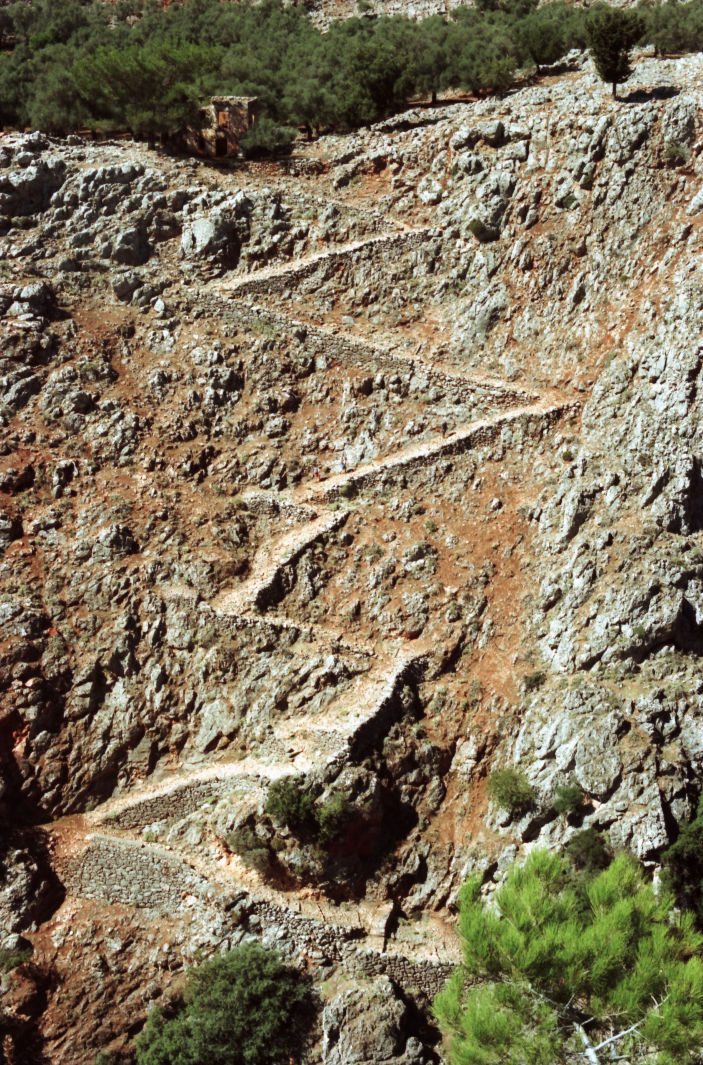
In the former Ottoman countries, a kaldırım (Turkish) or kalderimi (Greek: καλντερίμι or καλντιρίμι; plural ''kalderimia'') is a cobblestone-paved road built for hoofed traffic. ''Kalderimia'' are sometimes described as cobbled or paved mule tracks or trails. ''Kalderimia'' are typically 2 m wide, though there are reports of widths from 1 to 4.5 m, "so that two fully laden mules could pass each other without much difficulty". In Greece, the ''kalderimi'' network formerly linked almost every village, hamlet, chapel, and even sheepfold. There were thousands of kilometers of these roads in Crete alone. These roads are paved with flat stones. As they are designed for foot and hoofed traffic, they have steps where necessary, made of stones laid vertically. On flat stretches, they may be unpaved. On slopes, they have retaining walls. ''Kalderimia'' use switchbacks on steep ascents, and often have parapets next to steep slopes. When they cross streams ... [...More Info...] [...Related Items...] OR: [Wikipedia] [Google] [Baidu] |
Vikos Gorge
The Vikos Gorge or Vikos Canyon ( gr, Φαράγγι του Βίκου) is a gorge in the Pindus Mountains of north-western Greece. It lies on the southern slopes of Mount Tymphe with a length of about 32 km, depth ranging from 120 to 1350 m, and a width ranging from 2500 m to only a few meters at its narrowest part. Vikos is listed as the world's "deepest relative to its width" gorge by the Guinness Book of Records among others. Etymology There are a number of views regarding the etymology of the name: *According to Ioannis Lambridis it derives from Slavic and means 'chasm' or 'gorge'. *According to Evangelos Bogas it derives from the Greek βίκος 'stamnos with ears', which denotes the shape of the gorge and the echoes caused by sounds within it. The word was recorded in the lexicon of Hesychius of Alexandria. *According to Konstantinos Amantos it derives from the Greek phytonym βικίον. *According to Konstantinos Oikonomou it derives from an Albanian word for ... [...More Info...] [...Related Items...] OR: [Wikipedia] [Google] [Baidu] |
Tsepelovo
Tsepelovo ( el, Τσεπέλοβο) is a village in the Zagori region (Epirus region). It stands at a height of 1,200 meters in a panoramic location on the mountain range of Tymfi. It is the biggest of the 45 villages of Zagori and it was the seat of Tymfi municipality. Its name is of Slavic origin. It lies in the middle of the Vikos–Aoös National Park, 48 km from Ioannina. Nearest places * Skamneli, east (distance: 4 km) * Vradeto, west (distance: 7 km) Population History Founded in the 16th century, Tsepelovo became from the 18th century onwards the administrative center of Zagori. It remained relatively prosperous until the end of the Ottoman occupation (1912). The village was a local trade center, and remains so especially because of the trade of timber. In 1820, before the outbreak of the Greek Revolution and the defeat of Ali Pasha, the poet Ioannis Vilaras and the famous Epirote scholar Athanasios Psalidas came from Ioannina to prepare the people ... [...More Info...] [...Related Items...] OR: [Wikipedia] [Google] [Baidu] |
Tymfi, Greece
Tymfi ( el, Τύμφη) is a former municipality in the Ioannina regional unit, Epirus, Greece. Since the 2011 local government reform it is part of the municipality Zagori, of which it is a municipal unit. The municipal unit has an area of 428.296 km2. Population 862 (2011). The seat of the municipality was in Tsepelovo. It took its name from the Tymfi mountain. Subdivisions The municipal unit Tymfi is subdivided into the following communities: *Tsepelovo *Vradeto * Vrysochori * Iliochori *Kapesovo * Kipoi * Koukouli * Laista *Leptokarya * Negades *Skamneli Skamneli ( el, Σκαμνέλι) is a village in the Zagori region ( Epirus region), 54 km north of Ioannina. It is built in the fringes of mountain Tymfi (Mt Tymphe), at a height of 1160 m. Name The name "Skamneli" is of uncertain origi ... * Fragkades References Zagori Populated places in Ioannina (regional unit) {{Epirus-geo-stub de:Tymfi ... [...More Info...] [...Related Items...] OR: [Wikipedia] [Google] [Baidu] |
Tymfi
Tymphe (in Latin and English usage) or Tymfi (in the Greek government's preferred transliteration), Timfi, also Tymphi (, ) is a mountain in the northern Pindus mountain range, northwestern Greece. It is part of the regional unit of Ioannina and lies in the region of Zagori, just a few metres south of the 40° parallel. Tymphe forms a massif with its highest peak, Gamila, at . The massif of Tymphe includes in its southern part the Vikos Gorge, while they both form part of the Vikos–Aoös National Park which accepts over 100,000 visitors per year. The former municipality of the same name owed its name to the mountain. Etymology The exact meaning of the name is not known but has been in use since ancient times. The name "Tymphe" or "Stymphe" is mentioned by ancient geographer Strabo, Book 7, Ch. 7, and is associated with the ancient land of Tymphaea and the Tymphaeans, one of the tribes of Ancient Epirus. Despite its ancient use, the name does not appear in any descriptions of ... [...More Info...] [...Related Items...] OR: [Wikipedia] [Google] [Baidu] |
Skamneli
Skamneli ( el, Σκαμνέλι) is a village in the Zagori region ( Epirus region), 54 km north of Ioannina. It is built in the fringes of mountain Tymfi (Mt Tymphe), at a height of 1160 m. Name The name "Skamneli" is of uncertain origin. It may derive from the word "sycaminea" ( el, συκαμινέα, the sycamore of the Bible - the fig-mulberry tree). There are several villages and toponyms in Greece with the name Sycaminea or Sykamia. It is more likely, however, that the name is derived from the Greek "skamnos" (σκαμνός), "skamnon" (σκάμνον) or "skamni" (σκαμνί) ( la, scamnum, scannellum that means "seat" or "footstool") perhaps because the village itself seems like a seat and has an amphitheatric view. Skamneli is flanked by the steep cliff of Rhadio ( el, Ραδιό < ῥάδιον) meaning easy or accessible, (if so, either a euphemism or a reference to the road p ... [...More Info...] [...Related Items...] OR: [Wikipedia] [Google] [Baidu] |
Kapesovo
Kapesovo ( el, Καπέσοβο) is a village in the Zagori region (Epirus region), it is 43 km north of Ioannina. The name Kapesovo is Slavic and means garden. The village used to be more south near Baya (Kipi), where many vegetables were grown and it was called "Kapouska". It was later moved to its current position for health reasons. There is a big cliff next to the village called "Kapesios" (a Slavic word that means cliff) and the name of the village might be related to it. The village is near the Vikos canyon, the view of which is spectacular at certain spots. History In the 18th and 19th centuries Kapesovo was renowned in Epirus for its painters, called mpogades ( el, Μπογάδες), that worked in dozens of churches from Moscopole to Arta. Kapesovo experienced a great flourishing until 1860 and this is evident in the great manors with folk wall paintings and churches with paintings (hagiographies) in their interior. The church of Aghios Nikolaos, built in 1793, ... [...More Info...] [...Related Items...] OR: [Wikipedia] [Google] [Baidu] |
Sarakatsani
The Sarakatsani ( el, Σαρακατσάνοι, also written Karakachani, bg, каракачани) are an ethnic Greek population subgroup who were traditionally transhumant shepherds, native to Greece, with a smaller presence in neighbouring Bulgaria, southern Albania, and North Macedonia. Historically centred on the Pindus mountains and other mountain ranges in continental Greece, most Sarakatsani have abandoned the transhumant way of life and have been urbanised. Name The most widely accepted theory for the origin of the name "Sarakatsani" is that it comes from the Turkish word ''karakaçan'' (from ''kara'' = 'black' and ''kaçan'' = 'fugitive'), used by the Ottomans, in reference to those people who dressed in black and fled to the mountains during the Ottoman rule. According to another theory, the name derives from the village of Sakaretsi, the supposed homeland of the Sarakatsani. History and origin Despite the silence of the classical and medieval writers, scholars a ... [...More Info...] [...Related Items...] OR: [Wikipedia] [Google] [Baidu] |
Albanians
The Albanians (; sq, Shqiptarët ) are an ethnic group and nation native to the Balkan Peninsula who share a common Albanian ancestry, culture, history and language. They primarily live in Albania, Kosovo, North Macedonia, Montenegro, Serbia as well as in Croatia, Greece, Italy and Turkey. They also constitute a large diaspora with several communities established across Europe, the Americas and Oceania. Albanians have Paleo-Balkanic origins. Exclusively attributing these origins to the Illyrians, Thracians or other Paleo-Balkan people is still a matter of debate among historians and ethnologists. The first certain reference to Albanians as an ethnic group comes from 11th century chronicler Michael Attaleiates who describes them as living in the theme of Dyrrhachium. The Shkumbin River roughly demarcates the Albanian language between Gheg and Tosk dialects. Christianity in Albania was under the jurisdiction of the Bishop of Rome until the 8th century AD. Then, dioceses ... [...More Info...] [...Related Items...] OR: [Wikipedia] [Google] [Baidu] |
Eastern Orthodox Church
The Eastern Orthodox Church, also called the Orthodox Church, is the second-largest Christian church, with approximately 220 million baptized members. It operates as a communion of autocephalous churches, each governed by its bishops via local synods. The church has no central doctrinal or governmental authority analogous to the head of the Roman Catholic Church—the Pope—but the Ecumenical Patriarch of Constantinople is recognized by them as '' primus inter pares'' ("first among equals"), which may be explained as a representative of the church. As one of the oldest surviving religious institutions in the world, the Eastern Orthodox Church has played a prominent role in the history and culture of Eastern and Southeastern Europe. The Eastern Orthodox Church officially calls itself the Orthodox Catholic Church. Eastern Orthodox theology is based on holy tradition, which incorporates the dogmatic decrees of the seven ecumenical councils, the Scriptures, and the teachin ... [...More Info...] [...Related Items...] OR: [Wikipedia] [Google] [Baidu] |
Epirus (region)
Epirus (; el, Ήπειρος, translit=Ípiros, ) is a traditional geographic and modern administrative region in northwestern Greece.Π.Δ. 51/87 “Καθορισμός των Περιφερειών της Χώρας για το σχεδιασμό κ.λ.π. της Περιφερειακής Ανάπτυξης” (''Determination of the Regions of the Country for the planning etc. of the development of the regions, Efimeris tis Kyverniseos ΦΕΚ A 26/06.03.1987'' It borders the regions of Western Macedonia and Thessaly to the east, West Greece to the south, the Ionian Sea and Ionian Islands to the west and Albania to the north. The region has an area of about . It is part of the wider historical region of Epirus, which overlaps modern Albania and Greece but lies mostly within Greek territory. Geography and ecology Greek Epirus, like the region as a whole, is rugged and mountainous. It comprises the land of the ancient Molossians and Thesprotians and a small part of the la ... [...More Info...] [...Related Items...] OR: [Wikipedia] [Google] [Baidu] |


