|
Voyageurs National Park
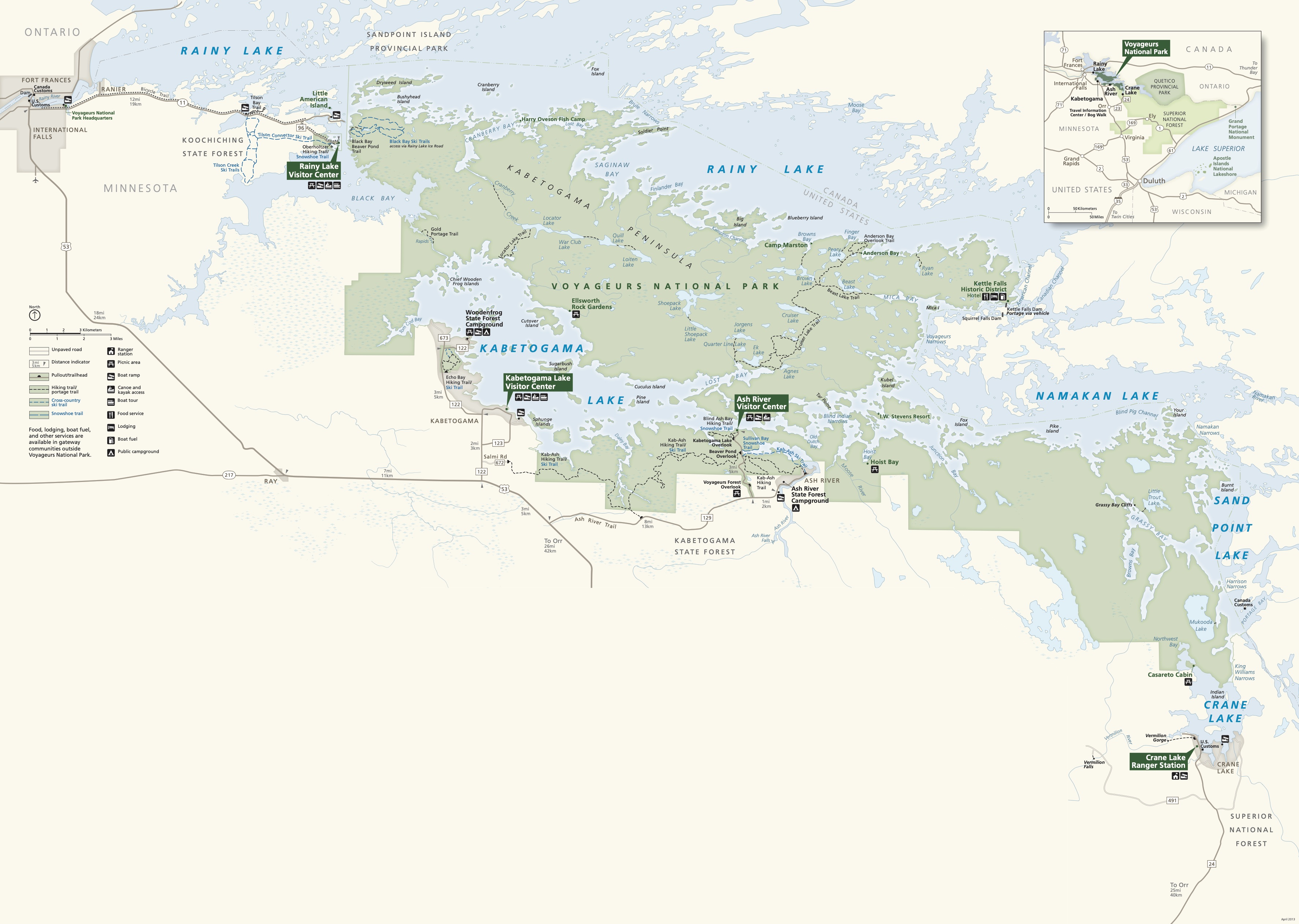
Voyageurs National Park is an American national park in northern Minnesota near the city of International Falls established in 1975. The park's name commemorates the ''voyageurs''—French-Canadian fur traders who were the first European settlers to frequently travel through the area. Notable for its outstanding water resources, the park is popular with canoeists, kayakers, other boaters, and fishermen. The Kabetogama Peninsula, which lies entirely within the park and makes up most of its land area, is accessible only by boat. To the east of the park lies the Boundary Waters Canoe Area Wilderness. The park has several boat ramps and visitor centers on its periphery, though the main body of the park is only accessible by boat or, in the winter, by snowmobile, ski, or snowshoe. In 2018, the park hosted 239,656 visitors. Geology Voyageurs National Park is located on the Canadian Shield, with the rocks averaging between 1 and 3 billion years old. These are some of the oldest r ... [...More Info...] [...Related Items...] OR: [Wikipedia] [Google] [Baidu] |
Koochiching County, Minnesota
Koochiching County ( ) is a county in the U.S. state of Minnesota. As of the 2020 census, the population was 12,062. Its county seat is International Falls. A portion of the Bois Forte Indian Reservation is in the county. A small part of Voyageurs National Park extends into its boundary, with Lake of the Woods County to its northwest. History About 10,000 years ago almost 90% of Koochiching County was covered by Lake Agassiz. When it receded it left low areas of decayed vegetation (muskeg); as a result, three-quarters of northern Koochiching are underlain with 2 to 50 feet of peat. The name "Koochiching" comes from either the Ojibwe word ''Gojijiing'' or Cree ''Kocicīhk'' (recorded in some documents as "Ouchichiq"), both meaning "at the place of inlets," referring to the neighboring Rainy Lake and River. Reverend J.A. Gilfillan recorded their meaning, "according to some, Neighbor lake, according to others a lake somewhere," possibly referring to the neighbouring Rainy Lake an ... [...More Info...] [...Related Items...] OR: [Wikipedia] [Google] [Baidu] |
NPS Voyageurs National Park Schematic Geologic Map
NPS may refer to: Organizations * National Park Service, U.S. * National Pension System, India * National Pension Service, Korea * National Phobics Society, UK charity * National Piers Society, UK charity * National Poetry Slam, competition * National Probation Service, a statutory criminal justice service for England and Wales * Nederlandse Programma Stichting, a Dutch broadcasting foundation now part of ''Omroep NTR'' * Nigerian Prisons Services * NPS MedicineWise, known prior to 2009 as the National Prescribing Service, a medical information provider in Australia * Nunavik Police Service in Quebec, Canada Science, medicine and pharmaceutics * Nail–patella syndrome, an autosomal dominant genetic disorder * Neuropeptide S, a neuropeptide found in human and mammalian brain * New psychoactive substance * Nonpoint source pollution * NPS Pharmaceuticals, acquired by Shire in 2015 Technology * Network Policy Server, component of Microsoft Server 2008 Pipes and pipe threads ... [...More Info...] [...Related Items...] OR: [Wikipedia] [Google] [Baidu] |
Strike-slip Fault
In geology, a fault is a planar fracture or discontinuity in a volume of rock across which there has been significant displacement as a result of rock-mass movements. Large faults within Earth's crust result from the action of plate tectonic forces, with the largest forming the boundaries between the plates, such as the megathrust faults of subduction zones or transform faults. Energy release associated with rapid movement on active faults is the cause of most earthquakes. Faults may also displace slowly, by aseismic creep. A ''fault plane'' is the plane that represents the fracture surface of a fault. A ''fault trace'' or ''fault line'' is a place where the fault can be seen or mapped on the surface. A fault trace is also the line commonly plotted on geologic maps to represent a fault. A ''fault zone'' is a cluster of parallel faults. However, the term is also used for the zone of crushed rock along a single fault. Prolonged motion along closely spaced faults can blur the ... [...More Info...] [...Related Items...] OR: [Wikipedia] [Google] [Baidu] |
Greenstone Belt
Greenstone belts are zones of variably metamorphosed mafic to ultramafic volcanic sequences with associated sedimentary rocks that occur within Archaean and Proterozoic cratons between granite and gneiss bodies. The name comes from the green hue imparted by the colour of the metamorphic minerals within the mafic rocks: the typical green minerals are chlorite, actinolite, and other green amphiboles. Greenstone belts also often contain ore deposits of gold, silver, copper, zinc and lead. A greenstone belt is typically several dozens to several thousand kilometres long. Typically, a greenstone belt within the greater volume of otherwise homogeneous granite-gneiss within a craton contains a significantly larger degree of heterogeneity and complications and forms a tectonic marker far more distinct than the much more voluminous and homogeneous granites. Additionally, a greenstone belt contains far more information on tectonic and metamorphic events, deformations, and paleogeologic ... [...More Info...] [...Related Items...] OR: [Wikipedia] [Google] [Baidu] |
Metamorphosed Rock
Metamorphic rocks arise from the transformation of existing rock to new types of rock in a process called metamorphism. The original rock (protolith) is subjected to temperatures greater than and, often, elevated pressure of or more, causing profound physical or chemical changes. During this process, the rock remains mostly in the solid state, but gradually recrystallizes to a new texture or mineral composition. The protolith may be an igneous, sedimentary, or existing metamorphic rock. Metamorphic rocks make up a large part of the Earth's crust and form 12% of the Earth's land surface. They are classified by their protolith, their chemical and mineral makeup, and their texture. They may be formed simply by being deeply buried beneath the Earth's surface, where they are subject to high temperatures and the great pressure of the rock layers above. They can also form from tectonic processes such as continental collisions, which cause horizontal pressure, friction, and distorti ... [...More Info...] [...Related Items...] OR: [Wikipedia] [Google] [Baidu] |
Precambrian
The Precambrian (or Pre-Cambrian, sometimes abbreviated pꞒ, or Cryptozoic) is the earliest part of Earth's history, set before the current Phanerozoic Eon. The Precambrian is so named because it preceded the Cambrian, the first period of the Phanerozoic Eon, which is named after Cambria, the Latinised name for Wales, where rocks from this age were first studied. The Precambrian accounts for 88% of the Earth's geologic time. The Precambrian is an informal unit of geologic time, subdivided into three eons ( Hadean, Archean, Proterozoic) of the geologic time scale. It spans from the formation of Earth about 4.6 billion years ago ( Ga) to the beginning of the Cambrian Period, about million years ago ( Ma), when hard-shelled creatures first appeared in abundance. Overview Relatively little is known about the Precambrian, despite it making up roughly seven-eighths of the Earth's history, and what is known has largely been discovered from the 1960s onwards. The Precambrian fossil ... [...More Info...] [...Related Items...] OR: [Wikipedia] [Google] [Baidu] |
Dike Swarm
A dike swarm (American spelling) or dyke swarm (British spelling) is a large geological structure consisting of a major group of parallel, linear, or radially oriented magmatic dikes intruded within continental crust or central volcanoes in rift zones. Examples exist in Iceland and near other large volcanoes, (stratovolcanoes, calderas, shield volcanoes and other fissure systems) around the world. They consist of several to hundreds of dikes emplaced more or less contemporaneously during a single intrusive event, are magmatic and stratigraphic, and may form a large igneous province. The occurrence of mafic dike swarms in Archean and Paleoproterozoic terrains is often cited as evidence for mantle plume activity associated with abnormally high mantle potential temperatures. Dike swarms may extend over in width and length. The largest dike swarm known on Earth is the Mackenzie dike swarm in the western half of the Canadian Shield in Canada, which is more than wide and ... [...More Info...] [...Related Items...] OR: [Wikipedia] [Google] [Baidu] |
Granitic
A granitoid is a generic term for a diverse category of coarse-grained igneous rocks that consist predominantly of quartz, plagioclase, and alkali feldspar. Granitoids range from plagioclase-rich tonalites to alkali-rich syenites and from quartz-poor monzonites to quartz-rich quartzolites. As only two of the three defining mineral groups (quartz, plagioclase, and alkali feldspar) need to be present for the rock to be called a granitoid, foid-bearing rocks, which predominantly contain feldspars but no quartz, are also granitoids. The terms ''granite'' and ''granitic rock'' are often used interchangeably for granitoids; however, granite is just one particular type of granitoid. Granitoids are diverse; no classification system for granitoids can give a complete and unique characterization of the origin, compositional evolution, and geodynamic environment for the genesis of a granitoid. Accordingly, multiple granitoid classification systems have been developed such as those based ... [...More Info...] [...Related Items...] OR: [Wikipedia] [Google] [Baidu] |
Gneiss
Gneiss ( ) is a common and widely distributed type of metamorphic rock. It is formed by high-temperature and high-pressure metamorphic processes acting on formations composed of igneous or sedimentary rocks. Gneiss forms at higher temperatures and pressures than schist. Gneiss nearly always shows a banded texture characterized by alternating darker and lighter colored bands and without a distinct cleavage. Gneisses are common in the ancient crust of continental shields. Some of the oldest rocks on Earth are gneisses, such as the Acasta Gneiss. Description Orthogneiss from the Czech Republic In traditional English and North American usage, a gneiss is a coarse-grained metamorphic rock showing compositional banding (gneissic banding) but poorly developed schistosity and indistinct cleavage. In other words, it is a metamorphic rock composed of mineral grains easily seen with the unaided eye, which form obvious compositional layers, but which has only a weak tendency to fracture ... [...More Info...] [...Related Items...] OR: [Wikipedia] [Google] [Baidu] |
Schist
Schist ( ) is a medium-grained metamorphic rock showing pronounced schistosity. This means that the rock is composed of mineral grains easily seen with a low-power hand lens, oriented in such a way that the rock is easily split into thin flakes or plates. This texture (geology), texture reflects a high content of platy minerals, such as micas, talc, chlorite group, chlorite, or graphite. These are often interleaved with more granular minerals, such as feldspar or quartz. Schist typically forms during regional metamorphism accompanying the process of mountain building (orogeny) and usually reflects a medium Metamorphism#Metamorphic grades, grade of metamorphism. Schist can form from many different kinds of rocks, including sedimentary rocks such as mudstones and igneous rocks such as tuffs. Schist metamorphosed from mudstone is particularly common and is often very rich in mica (a ''mica schist''). Where the type of the original rock (the protolith) is discernible, the schist is us ... [...More Info...] [...Related Items...] OR: [Wikipedia] [Google] [Baidu] |
Kenoran Orogeny
The Algoman orogeny, known as the Kenoran orogeny in Canada, was an episode of mountain-building (orogeny) during the Late Archean Eon that involved repeated episodes of continental collisions, compressions and subductions. The Superior province and the Minnesota River Valley terrane collided about 2,700 to 2,500 million years ago. The collision folded the Earth's crust and produced enough heat and pressure to metamorphose the rock. Blocks were added to the Superior province along a boundary that stretches from present-day eastern South Dakota into the Lake Huron area. The Algoman orogeny brought the Archean Eon to a close, about ; it lasted less than 100 million years and marks a major change in the development of the Earth's crust. The Canadian shield contains belts of metavolcanic and metasedimentary rocks formed by the action of metamorphism on volcanic and sedimentary rock. The areas between individual belts consist of granites or granitic gneisses that form fault zones. Th ... [...More Info...] [...Related Items...] OR: [Wikipedia] [Google] [Baidu] |
Physiographic Province
physiographic province is a geographic region with a characteristic geomorphology, and often specific subsurface rock type or structural elements. The continents are subdivided into various physiographic provinces, each having a specific character, relief, and environment which contributes to its distinctiveness. The physiographic provinces are then subdivided into smaller physiographic sections. Examples In eastern North America, the Atlantic Coastal Plain, Piedmont, Blue Ridge Mountains, Ridge-and-Valley Appalachians, and Appalachian Plateau are specific physiographic provinces. In the Western United States of western North America: the Basin and Range Province, Cascade Range, Colorado Plateau, Rio Grande rift, Great Basin, Central Valley (California), Peninsular Ranges, Los Angeles Basin, and Transverse Ranges are examples of physiographic provinces. See also * Physiographic provinces — index * Physiographic sections — index * Physiographic regions of the world — ''cha ... [...More Info...] [...Related Items...] OR: [Wikipedia] [Google] [Baidu] |


